Overview
|
A fairly localized cluster of thunderstorms developed over northeast Iowa and southwest Wisconsin Monday evening, July 11th 2017. The storms developed rapidly, becoming strong to severe. Large hail and damaging winds accompanied a few of the storms early, but the main threat quickly moved to heavy rainfall and flash flooding. Some of the higher rainfall totals:
|
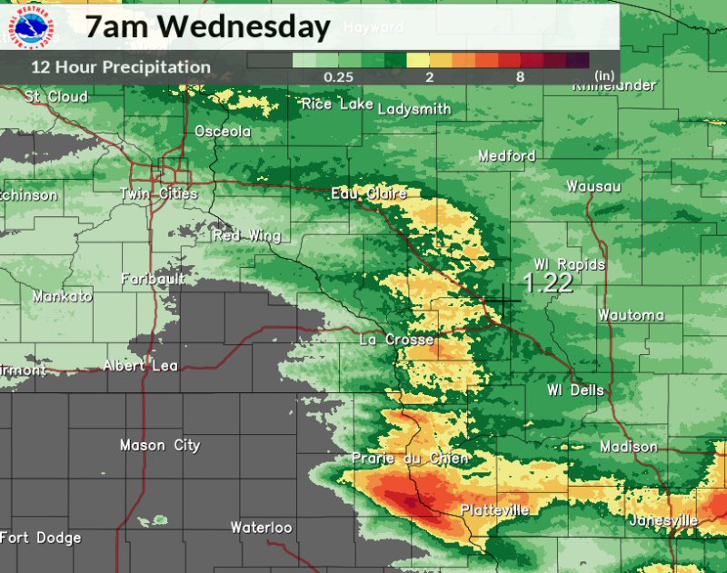 12 hour rainfall radar estimates, ending 7 am July 12, 2017 |
Flooding
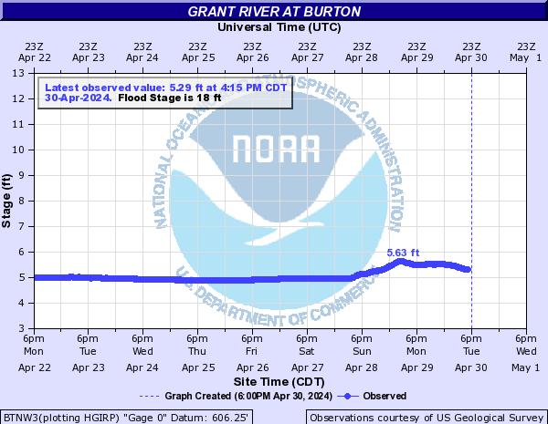
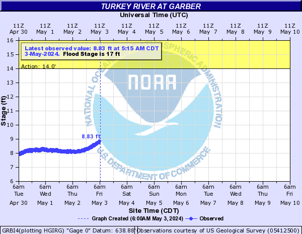
Hydrographs
 |
 |
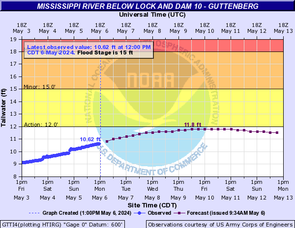 |
| Grant River at Burton, WI | Turkey River at Garber, IA | Mississippi River at Guttenberg, IA |
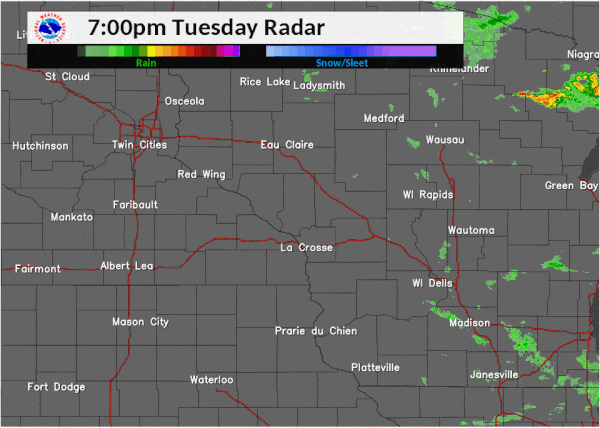
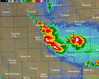
Radar:
 |
 |
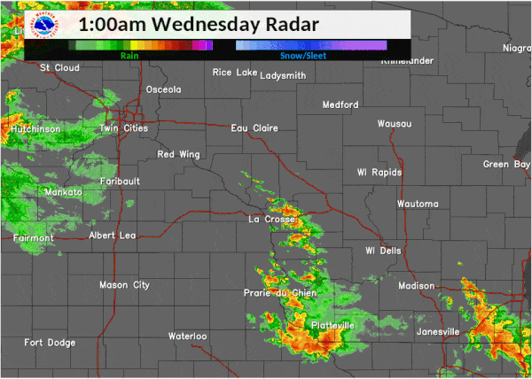 |
| Evening radar loop (July 11) | Zoomed view of southwest WI and northeast IA from 8 pm July 11 to 1 am July 12. | Overnight radar loop (July 12) |
Storm Reports
PRELIMINARY LOCAL STORM REPORT...SUMMARY
NATIONAL WEATHER SERVICE LA CROSSE WI
726 AM CDT WED JUL 12 2017

..TIME...   ...EVENT...      ...CITY LOCATION...     ...LAT.LON...
..DATE...   ....MAG....      ..COUNTY LOCATION..ST.. ...SOURCE....
            ..REMARKS..

0654 AM     HEAVY RAIN       1 NNW FERRYVILLE        43.36N 91.09W
07/12/2017  E4.00 INCH       CRAWFORD           WI   PUBLIC

            RELAYED VIA WKBT. THE DURATION OF THE HEAVY
            RAIN EVENT WAS 24 HOURS.

0654 AM     HEAVY RAIN       1 NNW FERRYVILLE        43.36N 91.09W
07/12/2017  E4.00 INCH       CRAWFORD           WI   PUBLIC

            RELAYED VIA WKBT.

0643 AM     HEAVY RAIN       1 N LANSING             43.37N 91.22W
07/12/2017  E5.25 INCH       ALLAMAKEE          IA   PUBLIC

            RELAYED VIA KCRG.

0643 AM     HEAVY RAIN       LANSING                 43.37N 91.22W
07/12/2017  E5.25 INCH       ALLAMAKEE          IA   PUBLIC

            RELAYED VIA KCRG. THE DURATION OF THE HEAVY
            RAIN EVENT WAS 24 HOURS.

0505 AM     HEAVY RAIN       1 N GUTTENBERG          42.81N 91.10W
07/12/2017  E5.65 INCH       CLAYTON            IA   PUBLIC

            RELAYED VIA KWWL. LOCATION ESTIMATED. THE
            DURATION OF THE HEAVY RAIN EVENT WAS 24
            HOURS.

0505 AM     HEAVY RAIN       2 N GUTTENBERG          42.81N 91.10W
07/12/2017  E5.65 INCH       CLAYTON            IA   PUBLIC

            RELAYED VIA KWWL. LOCATION ESTIMATED.

0425 AM     HEAVY RAIN       3 W SAINT JOSEPH        43.78N 91.10W
07/12/2017  M2.27 INCH       LA CROSSE          WI   MESONET

            MESONET STATION C4143, 3 W SAINT JOSEPH.

0400 AM     HEAVY RAIN       4 WSW SAINT OLAF        42.91N 91.47W
07/12/2017  M2.20 INCH       CLAYTON            IA   MESONET

            MESONET STATION BSHI4, ELKADER 5NW.

0345 AM     HEAVY RAIN       LITTLEPORT              42.75N 91.37W
07/12/2017  M2.22 INCH       CLAYTON            IA   MESONET

            MESONET STATION VLPI4, LITTLEPORT.

0315 AM     HEAVY RAIN       GARBER                  42.74N 91.26W
07/12/2017  M5.39 INCH       CLAYTON            IA   MESONET

            MESONET STATION GRBI4, GARBER.

0250 AM     FLASH FLOOD      CASSVILLE               42.72N 90.99W
07/12/2017                   GRANT              WI   LAW ENFORCEMENT

            ROCK SLIDE ALONG COUNTY ROAD VV AND ROAD
            WASHOUT NEAR CASSVILLE.

0239 AM     FLASH FLOOD      GARBER                  42.74N 91.26W
07/12/2017                   CLAYTON            IA   LAW ENFORCEMENT

            MANY ROADS WASHED OUT IN SOUTHEAST PART OF
            COUNTY.

0235 AM     HEAVY RAIN       4 W NORTH BUENA VISTA   42.69N 91.04W
07/12/2017  M8.25 INCH       CLAYTON            IA   PUBLIC

            RELAYED VIA LAW ENFORCEMENT.

0106 AM     HEAVY RAIN       1 N OSTERDOCK           42.74N 91.16W
07/12/2017  E8.20 INCH       CLAYTON            IA   PUBLIC

            REPORT RELAYED VIA BROADCAST MEDIA.

0103 AM     HEAVY RAIN       GUTTENBERG              42.79N 91.10W
07/12/2017  M5.48 INCH       CLAYTON            IA   PUBLIC

            RAINFALL THROUGH 1 AM. REPORT RELAYED VIA
            BROADCAST MEDIA.

1246 AM     HEAVY RAIN       1 N ELKADER             42.87N 91.40W
07/12/2017  M3.36 INCH       CLAYTON            IA   BROADCAST MEDIA

            3.36 INCHES REPORTED AT THE ELKADER CENTRAL
            COMMUNITY SCHOOLS.

1200 AM     HAIL             NORTH BUENA VISTA       42.68N 90.96W
07/12/2017  E1.00 INCH       CLAYTON            IA   LAW ENFORCEMENT


1126 PM     FLASH FLOOD      4 SSE OSTERDOCK         42.68N 91.12W
07/11/2017                   CLAYTON            IA   LAW ENFORCEMENT

            LAW ENFORCEMENT ARE EVACUATING RESIDENTS
            ALONG THE LITTLE TURKEY RIVER AND MILL CREEK
            SOUTHEAST OF OSTERDOCK, IA.

0953 PM     HAIL             1 N GARBER              42.76N 91.26W
07/11/2017  E1.75 INCH       CLAYTON            IA   LAW ENFORCEMENT


0950 PM     TSTM WND DMG     ELKADER                 42.86N 91.40W
07/11/2017                   CLAYTON            IA   LAW ENFORCEMENT

            POWER LINES DOWN IN ELKADER.

0950 PM     HAIL             GARNAVILLO              42.87N 91.24W
07/11/2017  E0.88 INCH       CLAYTON            IA   LAW ENFORCEMENT


0917 PM     HAIL             ELKADER                 42.86N 91.40W
07/11/2017  E0.88 INCH       CLAYTON            IA   LAW ENFORCEMENT

            NICKEL HAIL IN ELKADER.


&&

$$
Rain Reports
...24 hour Rainfall Reports as of 7 am July 12...

Location                     Amount    Time/Date       Lat/Lon

...Iowa...

...Allamakee County...
4 ENE Watson                 1.53 in   0645 AM 07/12   43.11N/91.26W
3 S Dorchester               0.56 in   0700 AM 07/12   43.42N/91.51W
Postville                    0.05 in   0700 AM 07/12   43.09N/91.56W

...Clayton County...
4 W North Buena Vista        8.25 in   0235 AM 07/12   42.69N/91.04W
Osterdock                    8.20 in   0106 AM 07/12   42.74N/91.16W
Guttenberg Dam 10            5.57 in   0600 AM 07/12   42.78N/91.10W
Garber                       5.39 in   0615 AM 07/12   42.74N/91.26W
Littleport                   2.22 in   0645 AM 07/12   42.75N/91.37W
Elkader 5NW                  2.20 in   0700 AM 07/12   42.91N/91.47W
Volga 1NE                    0.85 in   0600 AM 07/12   42.81N/91.52W
Elkader Turkey River         0.81 in   0645 AM 07/12   42.84N/91.40W
Marquette-Bloody Run Creek   0.78 in   0700 AM 07/12   43.04N/91.21W
Monona WWTP                  0.37 in   0700 AM 07/12   43.04N/91.40W

...Fayette County...
Fayette                      0.03 in   0700 AM 07/12   42.85N/91.82W
Eldorado                     0.01 in   0645 AM 07/12   43.05N/91.81W
Fayette-CWOP                 0.01 in   0707 AM 07/12   42.84N/91.80W

...Floyd County...
Charles City                 0.01 in   0700 AM 07/12   43.06N/92.67W

...Minnesota...

...Fillmore County...
Pilot Mound-Root River       0.13 in   0700 AM 07/12   43.78N/92.03W
1 SSE Pilot Mound            0.12 in   0700 AM 07/12   43.79N/92.03W
Lanesboro 2NE                0.05 in   0700 AM 07/12   43.73N/91.94W
Mabel                        0.03 in   0630 AM 07/12   43.52N/91.76W
Lanesboro-Root River         0.01 in   0630 AM 07/12   43.72N/91.98W
Preston Airport              0.01 in   0659 AM 07/12   43.68N/92.18W

...Houston County...
Mound Prairie                0.17 in   0645 AM 07/12   43.78N/91.45W
Caledonia                    0.11 in   0700 AM 07/12   43.63N/91.50W

...Wabasha County...
Kellogg-Zumbro River         1.15 in   0700 AM 07/12   44.32N/92.00W
Wabasha                      0.66 in   0700 AM 07/12   44.38N/92.05W
Bear Valley Alert Rain Gage  0.47 in   0446 AM 07/12   44.36N/92.51W
Lake City                    0.37 in   0442 AM 07/12   44.45N/92.27W
Lake City                    0.37 in   0650 AM 07/12   44.44N/92.28W
2 NNW Zumbro Falls           0.33 in   0717 AM 07/12   44.32N/92.44W
1 SSE Kellogg                0.01 in   0715 AM 07/12   44.28N/91.99W
Plainview                    0.01 in   0724 AM 07/12   44.17N/92.17W

...Winona County...
La Crescent Dam 7            0.64 in   0600 AM 07/12   43.87N/91.31W
Minnesota City Dam 5         0.60 in   0700 AM 07/12   44.16N/91.81W
Winona Dam 5A                0.47 in   0600 AM 07/12   44.09N/91.67W
Dakota                       0.42 in   0615 AM 07/12   43.91N/91.36W
1 ESE Minnesota City         0.22 in   0700 AM 07/12   44.08N/91.73W
Winona Municipal Airport     0.22 in   0652 AM 07/12   44.08N/91.71W
Beaver-White Water River     0.17 in   0645 AM 07/12   44.15N/92.00W
Elba                         0.01 in   0645 AM 07/12   44.09N/92.03W

...Wisconsin...

...Clark County...
Neillsville 1W               1.52 in   0700 AM 07/12   44.56N/90.61W

...Crawford County...
Ferryville                   3.64 in   0700 AM 07/12   43.33N/91.07W
Lynxville Dam 9              2.53 in   0600 AM 07/12   43.21N/91.10W
Prairie Du Chien             2.31 in   0700 AM 07/12   43.05N/91.13W
Steuben                      1.68 in   0645 AM 07/12   43.18N/90.86W
Prairie Du Chien  Airport    1.59 in   0655 AM 07/12   43.02N/91.12W
Steuben 4SE                  1.49 in   0537 AM 07/12   43.13N/90.84W
De Soto                      1.20 in   0721 AM 07/12   43.42N/91.19W

...Grant County...
Platteville Municipal Airpor 1.13 in   0655 AM 07/12   42.69N/90.44W
Boscobel Airport             0.87 in   0653 AM 07/12   43.16N/90.67W
1 ENE Boscobel               0.75 in   0703 AM 07/12   43.15N/90.68W
Muscoda                      0.55 in   0645 AM 07/12   43.20N/90.44W

...Jackson County...
Black River Falls 1.7 NNE    2.09 in   0700 AM 07/12   44.32N/90.83W
Black River Falls Area Airpo 1.94 in   0655 AM 07/12   44.25N/90.86W
Hatfield Dam                 1.75 in   0700 AM 07/12   44.41N/90.73W
1 E Black River Falls        1.20 in   0715 AM 07/12   44.30N/90.83W
Mather 3nw                   0.96 in   0700 AM 07/12   44.17N/90.35W

...Juneau County...
Necedah                      1.12 in   0648 AM 07/12   44.03N/90.08W
Mauston                      1.06 in   0722 AM 07/12   43.80N/90.07W
New Lisbon 4ene              0.92 in   0700 AM 07/12   43.91N/90.07W
Mauston Airport              0.91 in   0655 AM 07/12   43.84N/90.14W
2 N Cloverdale               0.80 in   0710 AM 07/12   44.06N/90.17W
2 WNW Wisconsin Dells        0.77 in   0730 AM 07/12   43.65N/89.82W
Volk Field                   0.55 in   0658 AM 07/12   43.94N/90.25W

...La Crosse County...
3 W Saint Joseph             2.75 in   0715 AM 07/12   43.78N/91.10W
La Crosse Weather Office     1.74 in   0600 AM 07/12   43.82N/91.19W
La Crosse Regional Airport   0.82 in   0653 AM 07/12   43.88N/91.26W

...Monroe County...
Four Corners                 2.84 in   0700 AM 07/12   44.09N/90.91W
Cashton 3NNW                 2.60 in   0709 AM 07/12   43.79N/90.80W
Tomah 5NNW                   2.25 in   0700 AM 07/12
2 E Cataract                 2.18 in   0728 AM 07/12   44.09N/90.79W
Warrens 4WSW                 1.13 in   0700 AM 07/12   44.10N/90.59W

...Taylor County...
Jump River 1 NW              1.37 in   0610 AM 07/12   45.36N/90.80W
Chelsea                      0.87 in   0719 AM 07/12   45.30N/90.30W
Medford Airport              0.48 in   0655 AM 07/12   45.10N/90.30W
3 NE Lublin                  0.44 in   0714 AM 07/12   45.11N/90.69W

...Trempealeau County...
1 NW Trempealeau             0.86 in   0700 AM 07/12   44.03N/91.46W
1 NE Galesville              0.78 in   0600 AM 07/12   44.10N/91.34W
Trempealeau Dam 6            0.67 in   0600 AM 07/12   44.00N/91.44W

...Vernon County...
Coon Valley                  1.73 in   0600 AM 07/12   43.70N/91.01W
Ontario                      1.50 in   0700 AM 07/12   43.72N/90.59W
Viroqua                      1.42 in   0700 AM 07/12   43.56N/90.88W
Viroqua Municipal Airport    1.23 in   0655 AM 07/12   43.58N/90.90W
Hillsboro 2sw                1.07 in   0700 AM 07/12   43.63N/90.38W
Hillsboro WSW                1.05 in   0700 AM 07/12   43.65N/90.35W
Readstown                    1.01 in   0700 AM 07/12   43.45N/90.76W
Stoddard                     0.90 in   0700 AM 07/12   43.66N/91.22W
Genoa Dam 8                  0.62 in   0600 AM 07/12   43.57N/91.23W

Observations are collected from a variety of sources with varying
equipment and exposures. We thank all volunteer weather observers
for their dedication. Not all data listed are considered official.

$$
Photos & Video:
 |
 |
 |
 |
| This "pond" flooded my yard and garage after the creek went over the banks in Blair, WI (Bobby Bishop) | County G at LaCrosse and Vernon county line (Heather L Euler) |
Flooding along County P in Vernon County (Heather L. Euler) | Flooding in Hegg, WI in Trempealeau County (Daryl Tjerstad) |
 |
 |
 |
 |
| Flooding in Hegg, WI in Trempealeau County (Daryl Tjerstad) | Below Middle Ridge (Heather L Euler) | This is normally a small stream in Monroe County (Jeannie Jones) | Flooding in Norwalk, WI (Carsen Culpitt) |
 |
 |
 |
 |
| Flooding in Norwalk, WI (Carsen Culpitt) | Wind damage in Ontario, WI (Candie Dunwald) | A tree came off the rock and covered the road in Pier County Park at Rockbridge WI. (Amanda Ruskamp) | South side of Tomah, WI at approximately 5:45 a.m. on July 12th (Kathy J Mitchell) |
.png) |
|||
| Wind damage in Tomah WI (Tonya Noggle) |
 |
Media use of NWS Web News Stories is encouraged! Please acknowledge the NWS as the source of any news information accessed from this site. |
|


 Weather Story
 Weather Map
 Local Radar