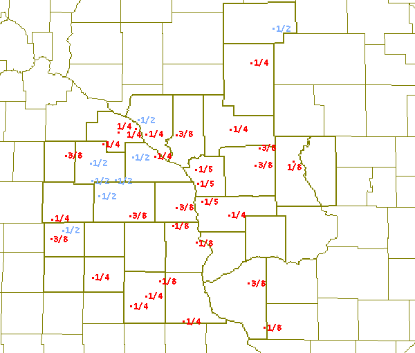
A cold front moved through the region Friday, December 31 and eventually become stationary south of the area on January 1st. Cold air settled in behind the front with temperatures falling from the 40s and 50s into the 20s and 30s. An upper level disturbance moved across the upper Midwest on January 1st and 2nd. As this disturbance moved through, air temperatures above the surface warmed above freezing, while surface temperatures remain below freezing. Freezing rain developed across southern Minnesota, northern Iowa into central and southern Wisconsin during the morning and afternoon of the 1st and continued into the early morning hours of the 2nd before shifting east of the area. Ice accumulations from the freezing rain ranged from little or none up to a half inch across portions of southeast Minnesota and western and north central Wisconsin.

Ice totals for January 2.
PUBLIC INFORMATION STATEMENT NATIONAL WEATHER SERVICE LA CROSSE WI 130 PM CST SUN JAN 2 2005 ...24 HOUR ICE ACCUMULATIONS AROUND THE AREA... LOCATION COUNTY ICE ACCUMULATION(INCHES) ======== ====== ========================= ...IOWA... STACEYVILLE MITCHELL 1/2" ST. ANSGAR 7NW MITCHELL 3/8" FAYETTE FAYETTE 1/4" IONIA 2W CHICKASAW 1/4" WESTGATE 3N FAYETTE 1/4" EDGEWOOD CLAYTON 1/8-1/4" CLERMONT FAYETTE 1/8" DORCHESTER ALLAMAKEE 1/8" LANSING 4SE ALLAMAKEE 1/8" ...MINNESOTA... ALTURA 5W WINONA 1/2" CHATFIELD OLMSTED 1/2" SPRING VALLEY FILLMORE 1/2" STEWARTVILLE OLMSTED 1/2" CALEDONIA 6S HOUSTON 3/8" HARMONY FILLMORE 3/8" MANTORVILLE 3E DODGE 3/8" ROCHESTER OLMSTEAD 1/4-1/2" BYRON OLMSTED 1/4" ELGIN 2SSW OLMSTEAD 1/4" GOODVIEW WINONA 1/4" LYLE 2NE MOWER 1/4" KELLOG 4S WABASHA 1/4" THEILMAN 1SSW WABASHA 1/4" ...WISCONSIN... ALMA DAM 4 BUFFALO 1/2" MEDFORD TAYLOR 1/2" FENNIMORE GRANT 3/8" TUNNEL CITY MONROE 3/8" WARRENS MONROE 3/8" ARCADIA TREMPEALEAU 1/4" BLACK RIVER FALLS JACKSON 1/4" COCHRANE BUFFALO 1/4" LONGWOOD CLARK 1/4" MATHER 3NW JACKSON 1/4" VIROQUA VERNON 1/4" HOLMEN LA CROSSE 1/5" LA CROSSE WFO LA CROSSE 1/5" STODDARD 3NE LA CROSSE 1/5" CUBA CITY 2W GRANT 1/8" NECEDAH JUNEAU 1/8" $$ |