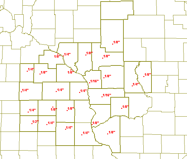
February 24, 2001 Ice Totals
A strong area of low pressure developed over eastern Colorado on Friday, February 23rd. As the low moved northeast into Kansas Friday, warm air streamed northward into the upper Midwest ahead of the low. A mixed bag of precipitation broke out across the region Friday night. Over southwest Wisconsin and northeast Iowa, surface temperatures remained below freezing while just a few thousand feet above the surface, temperatures were in the 50s. This allowed the precipitation to fall as freezing rain. Across sections of southeast Minnesota and western Wisconsin, temperatures were initially cold enough for the precipitation to fall as snow, but the snow quickly changed over to freezing rain as the warmer air aloft spread over the entire region. The freezing rain created anywhere from 1/16th to a 1/2 inch of ice on exposed surface. As the low continued to move northeast Saturday and Saturday night, surface temperatures eventually warmed to above freezing changing all the freezing rain over to rain and helped to melt the ice that had accumulated. The low passed over southeast Minnesota Saturday night and as it did, a warm front moved across the region and pushed temperatures over southwest Wisconsin into the middle 40s. A few thunderstorms also moved across the region Saturday night with the warm front. The low continued to move northeast across Wisconsin Sunday spreading very windy conditions across the region. Wind gusts ranged from 38 mph at Winona Minnesota to 50 mph at Rochester Minnesota.

Ice totals for February 24th.
ZCZC MKEPNSLSE
ABUS34 KLSE 242020
PUBLIC INFORMATION STATEMENT
NATIONAL WEATHER SERVICE LA CROSSE WI
215 PM CST SAT FEB 24 2001

                                              ICE
LOCATION            COUNTY       STATE    ACCUMULATION
--------            ------       -----    ------------
CRESCO              HOWARD        IA          1/8"
DECORAH             WINNESHIEK    IA          1/8"
AUSTIN              MOWER         MN          1/4"
LANCASTER           GRANT         WI          1/8"
ELKADER             CLAYTON       IA          1/4"
NEW HAMPTON         CHICKASAW     IA          1/4"
OSAGE               MITCHELL      IA          1/4"
WEST UNION          FAYETTE       IA          1/4"
CHARLES CITY        FLOYD         IA          1/2"
PRAIRIE DU CHIEN    CRAWFORD      WI          1/8"
RICHLAND CENTER     RICHLAND      WI          1/8"
DODGE CENTER        DODGE         MN          1/4"
ROCHESTER           OLMSTED       MN          1/8"
PRESTON             FILLMORE      MN          1/4"
SPARTA              MONROE        WI          1/8"
FRIENDSHIP          ADAMS         WI          1/8"
NEILSVILLE          CLARK         WI          1/8"
ALMA                BUFFALO       WI          1/4"
WHITEHALL           TREMPEALEAU   WI          1/8"
BLACK RIVER FALLS   JACKSON       WI          1/8"
MAUSTON             JUNEAU        WI          1/4"
CALEDONIA           HOUSTON       WI          1/4"
WINONA              WINONA        WI          1/8"
WABASHA             WABASHA       WI          1/8"
VIROQUA             VERNON        WI         1/16"
NWS LA CROSSE       LA CROSSE     WI         1/16"


A SPECIAL THANKS GOES OUT TO THE LAW ENFORCEMENT AGENCIES
AND THE SPOTTERS WHICH CONTRIBUTED TO THIS REPORT THIS
MORNING.
$$

DTJ
NNNN
ZCZC MKEPNSLSE
ABUS34 KLSE 252147
PUBLIC INFORMATION STATEMENT
NATIONAL WEATHER SERVICE LA CROSSE WI
345 PM CST SUN FEB 25 2001

...HERE ARE THE PEAK WIND GUSTS AS OF 330 PM THIS AFTERNOON...

LOCATION          COUNTY    STATE    WIND GUST

ROCHESTER         OLMSTED    MN    50 MPH AT 719 AM
AUSTIN            MOWER      MN    41 MPH AT 835 AM
DODGE CENTER      DODGE      MN    40 MPH AT 157 PM
WINONA            WINONA     MN    38 MPH AT 917 AM
LA CROSSE ARPT    LA CROSSE  WI    44 MPH AT 717 AM
LA CROSSE NWS     LA CROSSE  WI    48 MPH AT 721 AM
BOSCOBEL          GRANT      WI    43 MPH AT 732 AM
PRAIRIE DU CHIEN  CRAWFORD   WI    43 MPH AT 138 PM
MEDFORD           TAYLOR     WI    40 MPH AT 141 PM

$$
Additional totals received through our web site:
| Location | County | Snowfall |
| Necedah 2S | Juneau | 0.5" |