Extremely critical fire weather concerns for portions of the southern High Plans as strong wind and very dry conditions could result in rapid spread of any fires. Meanwhile, severe thunderstorms are expected once again across areas of the Central and Southern Plains, then spreading in the Mississippi Valley regions on Monday. Damaging winds, very large hail and strong tornadoes are possible. Read More >
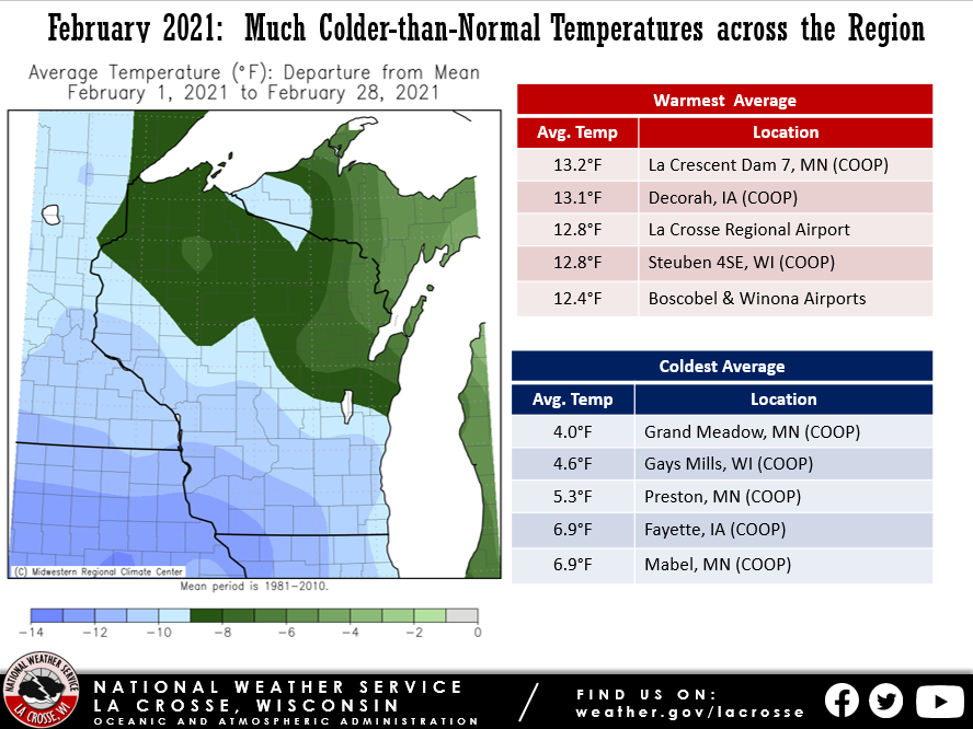
During February 2021, temperatures were 8 to 13F colder-than-normal across the Upper Mississippi River Valley. This was the first month to be colder-than-normal since October 2020. Monthly average temperatures ranged from 4F at Grand Meadow, MN to 13.2F at La Crescent Dam 7, MN.
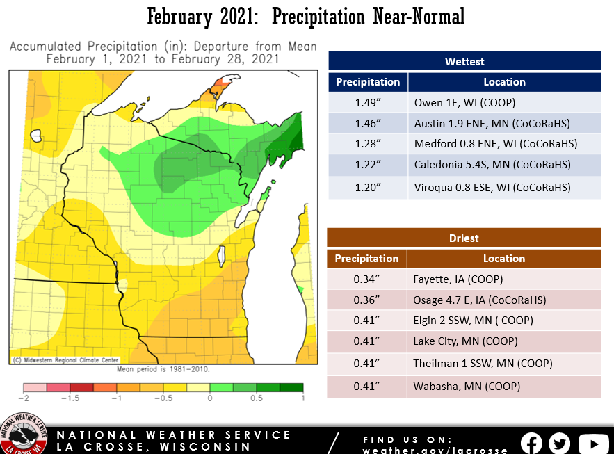
Precipitation totals ranged from 0.34” Fayette, IA to 1.49” at Owen 1E, WI. These precipitation values were close to normal.
Snowfall was near- to above-normal across the Upper Mississippi River Valley. The highest snow total was 16.2 inches near Wilton, WI.
 |
 |
 |
| Temperature Departures | Precipitation Departures | Snowfall Departures |
Additional details can found for La Crosse WI and Rochester MN.
...February 2021 was Colder and Drier, but Snowier, than Normal
in La Crosse, WI...

...Month Highlights...

The main story of February 2021 was the cold stretch of 17 days
below normal from the 5th through the 21st. Daily average
temperature departures were double digits below normal each day,
except the 21st, with the largest departure being 31 below normal
on the 14th and 15th. In fact, La Crosse remained below 0 the
whole day on the 14th, with a high of -2 being the coldest high
temperature for a Valentines Day in La Crosse`s period of record.
Despite the long stretch of cold, only 3 daily records were set or
tied (detailed in the Records section below).

Following the cold, we did see a warm up to end the month, with
the final 7 days being above normal, all of which reached at least
40 degrees for a high temperature.

Despite being overall drier than normal, February was snowier
than normal, with 12.1 inches being 3.9 inches above normal. A
vast majority of this snow fell on the 4th (5.8 inches) and the
21st (4.4 inches).

...Records...

The high temperature on February 13th was 0 degrees, tying the
daily record for coldest high temperature, first set in 1905.

The high temperature on February 14th was -2 degrees, breaking
the daily record for coldest high temperature of 1 degree, set in
1923.

The low temperature on February 15th was -21 degrees, breaking
the daily record low temperature of -16 degrees, last reached in
1905.
...February 2021 was Colder and Drier than Normal with Near
Normal Snowfall in Rochester, MN...

...Month Highlights...

The main story of February 2021 was the cold stretch of 16 days
below normal from the 5th through the 20th. Daily average
temperature departures were double digits below normal each day,
with the largest departure being 33 below normal on the 14th and
15th. In fact, Rochester remained below 0 from the 11th through
the 15th, with the highest temperature in that stretch being -2 on
the 11th. The coldest high in that stretch was -8 on the 14th,
making this the coldest high temperature for Valentine`s Day in
Rochester`s period of record. Despite the long stretch of cold,
only 4 daily records were set or tied (detailed in the Records
section below).

Following the cold, we did see a bit of warm up to end the month,
with 6 of the final 8 days being above normal. The warmest day
was the 27th, when the high was 41 degrees. This was the only day
above 40 degrees for the month. Rochester typically sees 3 such
days in February.

Precipitation-wise, February 2021 was not that atypical in
Rochester. While it was a bit drier than normal (by 0.18 inches),
the total snowfall of 8.7 inches for the month was 0.2 inches
above normal. Accumulating snow fell on 6 days, which was right at
the average.

...Records...

The high temperature on February 12th was -6 degrees, breaking
the daily record for coldest high temperature of -3 degrees, last
reached in 1917.

The high temperature on February 13th was -3 degrees, breaking
the daily record for coldest high temperature of 2 degrees, set in
2020.

The high temperature on February 14th was -8 degrees, breaking
the daily record for coldest high temperature of 1 degree, set in
1943.

The low temperature on February 15th was -23 degrees, breaking
the daily record low temperature of -19 degrees, last reached in
1939.