February 8-9, 2001 Snow and Ice Totals
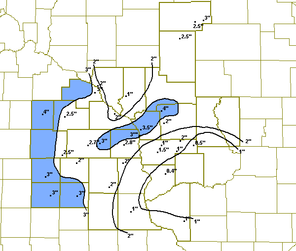
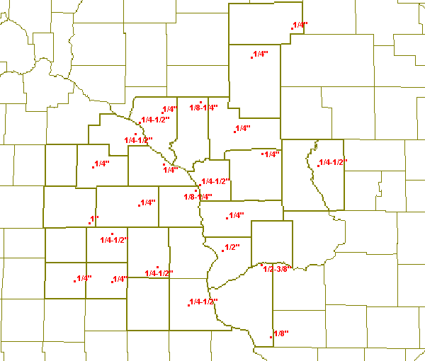
The cold front that helped to produce the snow and ice on the 7th and 8th of February, would be a major player in the snow and ice event from late on the 8th into the 9th. The front moved from eastern Wisconsin and central Illinois into western Wisconsin and eastern Iowa. This allowed surface temperatures to warm to freezing or above over much of western Wisconsin and portions of northeast Iowa. However, temperatures just a few thousand feet above the surface were well above freezing and this allowed the precipitation to fall as rain during the afternoon and evening of the 8th. Over southeast Minnesota and much of northeast Iowa, this rain froze when it hit the ground as air temperatures were still below freezing. Significant icing occurred in this region, with ice accumulations around a half inch common along with locally higher amounts up to one inch. As the main storm system moved out of the lower plains toward the upper Midwest during the early morning hours of the 9th, the front moved slowly east allowing colder air to filter into the region and change the freezing rain over to snow. In southwest Wisconsin along the Illinois border, temperatures started in the middle 30s and the precipitation was all rain, but as the colder air moved in, the rain changed to freezing rain and eventually over to snow during the morning of the 9th. Ice accumulations across the remainder of northeast Iowa into western Wisconsin were mainly in the quarter to half in range. Snowfall amounts across the entire region ranged from an inch or less for southwest Wisconsin up to four inches in parts of southeast Minnesota.

Snow totals for February 8th and 9th.

Ice accumulations for February 8th and 9th.
ZCZC MKEPNSLSE
ABUS34 KLSE 092000

PUBLIC INFORMATION STATEMENT
NATIONAL WEATHER SERVICE LA CROSSE WI
145 PM CST FRI FEB 09 2001

24 HOUR SNOW AND ICE ACCUMULATION ENDING 9AM

LOCATION           COUNTY     SNOWFALL/ICE ACCUMULATION

...IOWA...
CHARLES CITY      FLOYD       3.0 1/4 INCH ICE ACCUMULATION
LIME SPRINGS      HOWARD      2.0 1/4-1/2 INCH ICE ACCUMULATION
OSSIAN            WINNESHIEK  2.0 1/4-1/2 INCH ICE ACCUMULATION
OSAGE             MITCHELL    3.0 SOME ICE ACCUMULATION
DORCHESTER        ALLAMAKEE   2.0 1/4 INCH ICE ACCUMULATION
ELKADER           CLAYTON     1.0 1/4-1/2 INCH ICE ACCUMULATION
NEW HAMPTON       CHICKASAW   3.0 1/4 INCH ICE ACCUMULATION

...MINNESOTA...
CALEDONIA         HOUSTON     2.8
DODGE CENTER      DODGE       4.0
LE ROY            MOWER       2.5 1 INCH ICE ACCUMULATION
HIGHLAND          FILLMORE    3.0 1/4 INCH ICE ACCUMULATION
LA CRESCENT 1N    HOUSTON     3.0 1/8-1/4 INCH ICE ACCUMULATION
PRESTON           FILLMORE    2.7
ROCHESTER         OLMSTED     2.5 1/4 INCH ICE ACCUMULATION
KELLOG            WABASHA     3.0 1/4-1/2 INCH ICE ACCUMULATION
WINONA            WINONA      2.0 1/4 INCH ICE ACCUMULATION

...WISCONSIN...
ARCADIA           TREMPEALEAU 1.0
OSSEO             TREMPEALEAU     1/8-1/4 ICE ACCUMULATION
GILMANTON         BUFFALO         1/4 INCH ICE ACCUMULATION

ALMA              BUFFALO     2.0 1/4-1/2 INCH ICE ACCUMULATION
MT STERLING       CRAWFORD        1/2 INCH ICE ACCUMULATION

ELK MOUND         DUNN        1.5
FOUR CORNERS      MONROE      4.0
WARRENS           MONROE          1/4 INCH ICE ACCUMULATION
ARKDALE           ADAMS           1/4-1/2 INCH ICE ACCUMULATION
GOOKDDRICH        TAYLOR      3.0 1/4 INCH ICE ACCUMULATION
GAYS MILLS        CRAWFORD    0.4
HILLSBORO         VERNON      0.5
HOLCOMBE          CHIPPEWA    2.0
BLACK RIVER FALLS JACKSON         1/4 INCH ICE ACCUMULATION
LA CROSSE         LA CROSSE       1/4-1/2 INCH ICE ACCUMULATION
LA CROSSE 1N      LA CROSSE   3.0
LA CROSSE 4NNW    LA CROSSE   2.3
LA CROSSE NWS     LA CROSSE   3.5
LA FARGE          VERNON      1.0
MEDFORD COOP      TAYLOR      2.5
WITHEE            CLARK           1/4 INCH ICE ACCUMULATION
ONTARIO           VERNON      2.0
OWEN 3S           CLARK       2.5
CUBA CITY         GRANT           1/8 INCH ICE ACCUMULATION
PLATTEVILLE       GRANT       1.0
BLUE RIVER        GRANT           1/2-3/8 INCH ICE ACCUMULATION
SPARTA            MONROE      2.0
VIROQUA           VERNON      1.5 1/4 INCH ICE ACCUMULATION
WESTBY 1NE        VERNON      1.0
NNNN
Additional totals received through our web site:
| Location | County | Snowfall |
| Holmen 2S | La Crosse | 2" |
| Necedah 2S | Juneau | 1" |