Overview
|
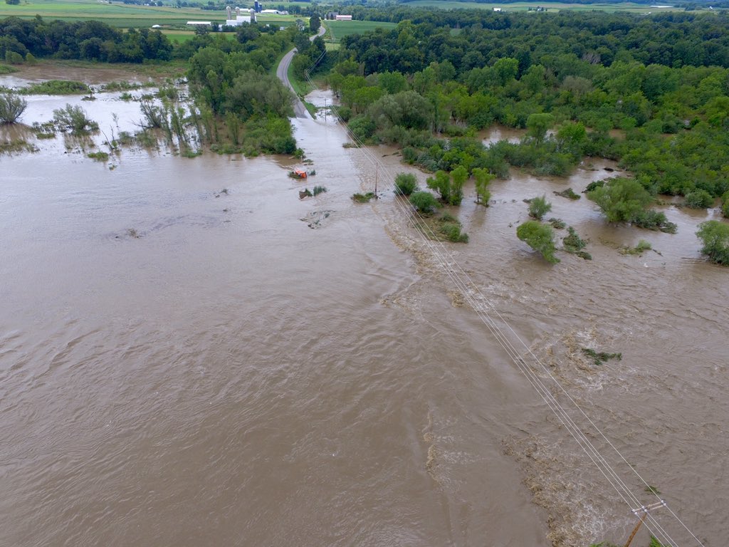
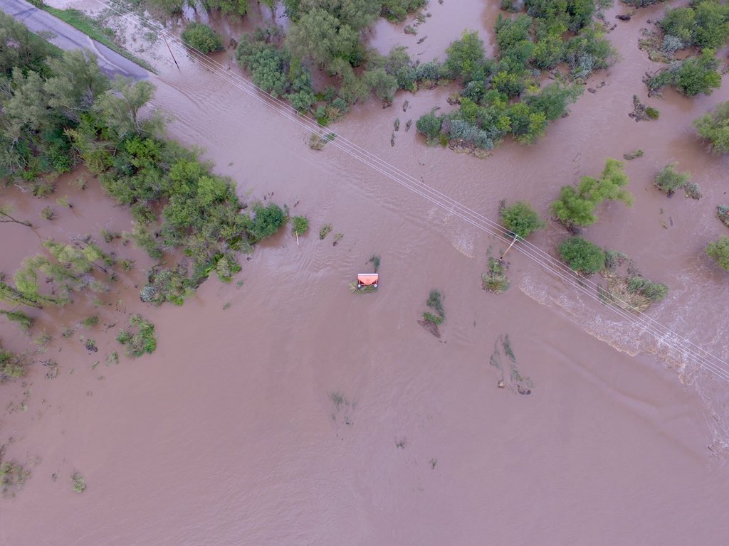
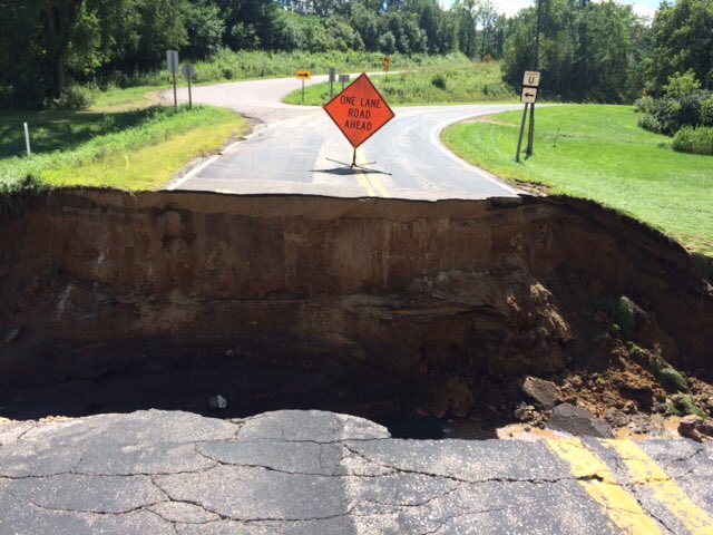
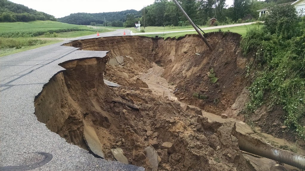
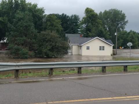
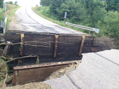
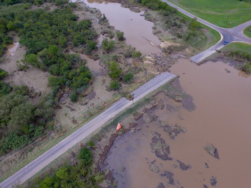
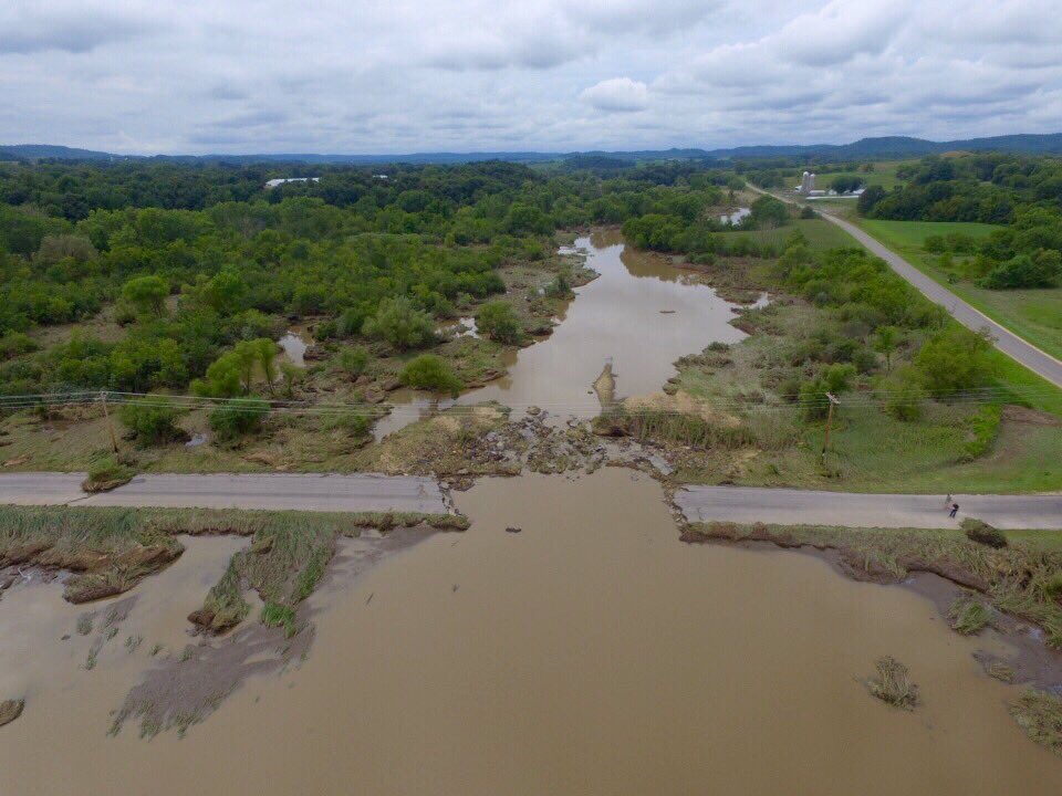
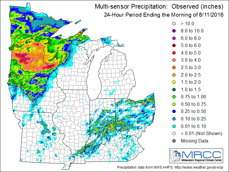
Rounds of thunderstorms brought heavy rain to parts of southeast Minnesota and west central Wisconsin during the early morning hours of August 11, 2016. Rainfall totals were 4 to 8 inches over a several county area that led to flash flooding and mudslides. All the rain and associated flooding caused extensive damage to many area highways and secondary roads, including damage to culverts and bridges. Gaps in roads formed from all the washouts and many roads were closed. There were even rescues and towns that became "islands" surrounded by rising waters. |
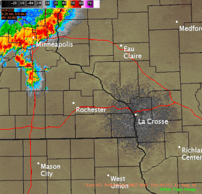
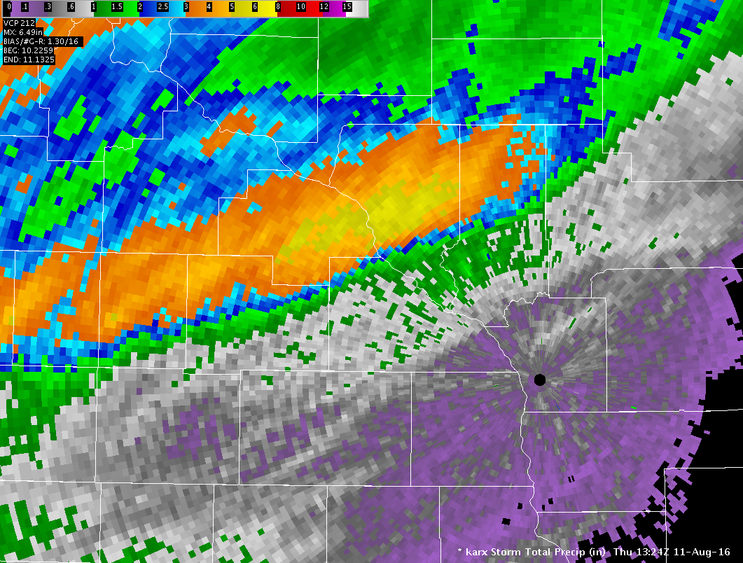 Axis of heavy rain (estimated by radar) from August 11, 2016 |
Flooding
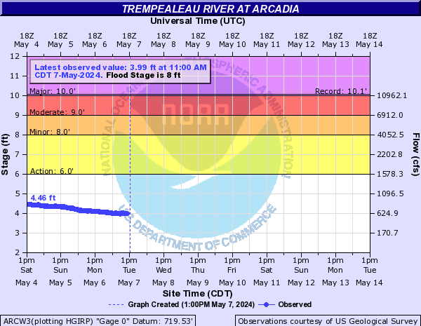
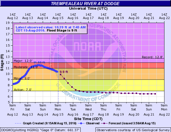
Graph shows river level and forecast.
Hydrographs
 |
 |
||
| Trempealeau River at Arcadia, WI | Trempealeau River at Dodge, WI |
Photos:
 |
 |
 |
 |
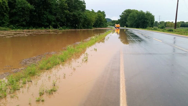
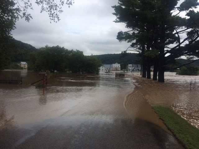
| Flooding between Cochrane and Alma, WI in Buffalo County. (Permission to use photo granted by Liz Schwab) |
Flooding between Cochrane and Alma, WI in Buffalo County. (Permission to use photo granted by Liz Schwab) |
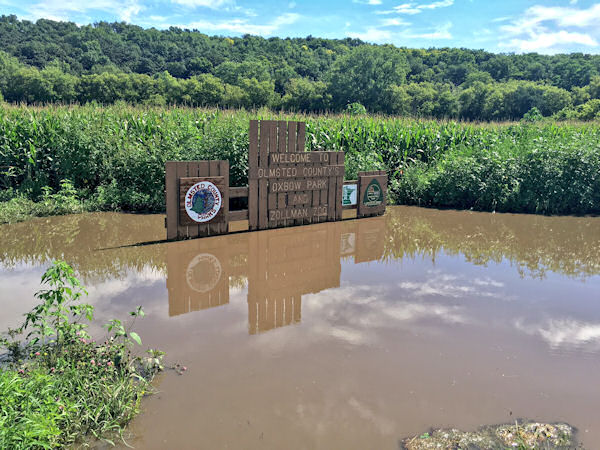
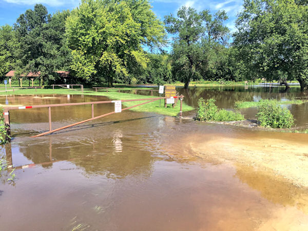
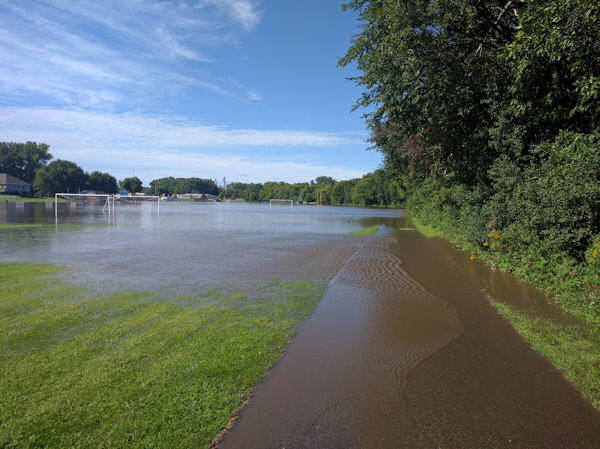
Flooding in Oxbow Park in Olmsted Co., MN. (Permission to use photo by KAAL-TV News) |
Flooding in Oxbow Park in Olmsted Co., MN. (Permission to use photo by KAAL-TV News) |
 |
 |
 |
 |
| Flooding in Cream, WI (Permission to use photo granted by WisDOT) |
Flooding south of Gilmanton, WI (Permission to use photo granted by WisDOT) |
Flooding west of Gilmanton, WI (Permission to use photo granted by Jon McCabe) |
Flooding west of Gilmanton, WI (Permission to use photo granted by Jon McCabe) |
 |
 |
 |
 |
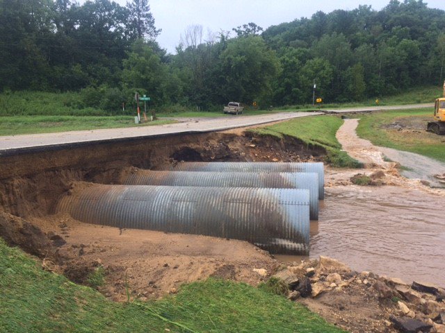
| Damage along Highway 88 north of County U in Buffalo Co., WI. (Permission to use photo granted by WisDOT) |
Flooding in Town of Alma on County Road N near Highway 37 in Buffalo Co., WI. (Permission to use photo granted by Wisconsin Emergency Management) |
Flooding in Gilmanton, WI. (Permission to use photo granted by Karla Lay) |
Flooding in Gilmanton, WI. (Permission to use photo granted by Karla Lay) |
 |
 |
 |
|
| Flood damage near County Road B and Sand Road west of Gilmanton, WI. (Permission to use photo granted by Jon McCabe) |
Flood damage near County Road B and Sand Road west of Gilmanton, WI. (Permission to use photo granted by Jon McCabe) |
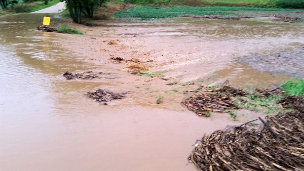
Flooded field near Pine Island, MN. (Permission to use photo granted by Eric Hall) |
Radar:
 |
 |
 |
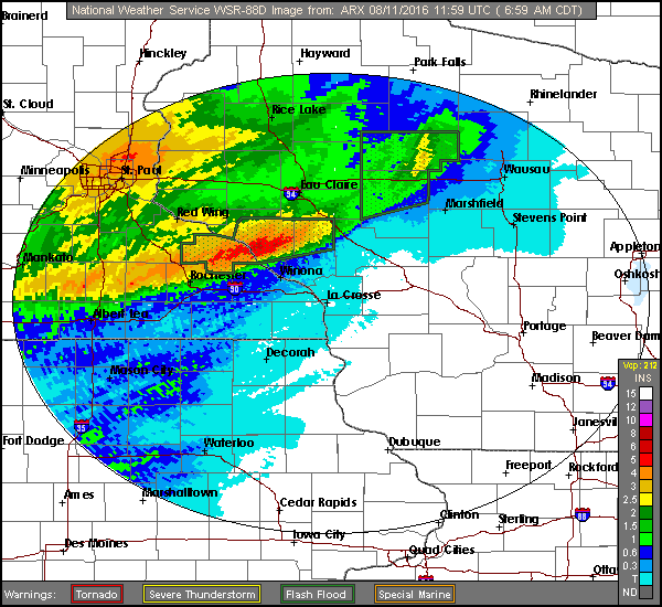
| Radar loop overnight Aug.10-11th (10pm to 9am) |
Rainfall estimates ending 7 a.m. Aug.11th | Regional rainfall |
Storm Reports
..TIME...   ...EVENT...      ...CITY LOCATION...     ...LAT.LON...
..DATE...   ....MAG....      ..COUNTY LOCATION..ST.. ...SOURCE....
            ..REMARKS..

0630 AM     FLASH FLOOD      ARCADIA                 44.25N 91.49W
08/11/2016                   TREMPEALEAU        WI   TRAINED SPOTTER
            STREET FLOODING FROM QUICK 2 INCHES OF RAIN.

0630 AM     FLASH FLOOD      1 NNW ALMA              44.33N 91.92W
08/11/2016                   BUFFALO            WI   EMERGENCY MNGR
            4 TO 6 INCHES OF RAIN FELL VERY QUICKLY.
            LOSS BRIDGES AND HIGHWAY 35 SOUTH OF ALMA
            HAD WATER OVER ROAD FOR 45 MIN. LOTS OF
            SECONDARY ROAD DAMAGE...VERY WIDESPREAD.

0645 AM     FLASH FLOOD      2 NNE BUFFALO           44.26N 91.85W
08/11/2016                   BUFFALO            WI   TRAINED SPOTTER
            5 INCHES OF RAIN LED TO FLOODING BETWEEN
            ALMA AND COCHRANE THIS MORNING.

0736 AM     FLASH FLOOD      ELEVA                   44.58N 91.47W
08/11/2016                   TREMPEALEAU        WI   LAW ENFORCEMENT
            WATER OVER PARTS OF HIGHWAYS 93 AND 121 IN
            NORTHWEST TREMPEALEAU COUNTY. SOME ROADS MAY
            BE CLOSED SOON. SOME BEING WASHED OUT OR
            DAMAGED.

0744 AM     FLASH FLOOD      4 SE LAKE CITY          44.41N 92.22W
08/11/2016                   WABASHA            MN   911 CALL CENTER
            SEVERAL WASHOUTS WITH MUDSLIDES REPORTED
            NEAR HIGHWAY 61 AND COUNTY ROADS 4 AND
            13...INCLUDING WASHOUTS AND TREE DAMAGED.

0745 AM     FLASH FLOOD      3 NNE DORCHESTER        45.04N 90.31W
08/11/2016                   TAYLOR             WI   PUBLIC
            CREEL/STREAM OUT OF BANKS.

0754 AM     FLASH FLOOD      3 NW INDEPENDENCE       44.39N 91.46W
08/11/2016                   TREMPEALEAU        WI   LAW ENFORCEMENT
            LOTS OF WATER OVER COUNTY ROAD Q.

0756 AM     FLASH FLOOD      URNE                    44.50N 91.90W
08/11/2016                   BUFFALO            WI   911 CALL CENTER
            LANDSLIDES HAVE UNDERMINDED SEVERAL ROADS.

0805 AM     FLASH FLOOD      ELEVA                   44.58N 91.47W
08/11/2016                   TREMPEALEAU        WI   LAW ENFORCEMENT
            WATER OVER HIGHWAY 93 ALONG WITH COUNTY
            ROADS D...O...E...AND OO.

0823 AM     FLASH FLOOD      3 SW STRUM              44.52N 91.43W
08/11/2016                   TREMPEALEAU        WI   LAW ENFORCEMENT
            SECTION OF ROAD WASHED OUT AT HIGHWAY 93 AND
            COUNTY ROAD H.

0835 AM     FLASH FLOOD      4 NNW CREAM             44.36N 91.81W
08/11/2016                   BUFFALO            WI   LAW ENFORCEMENT
            COUNTY ROAD N NEAR HIGHWAY 37 HAS A DEEP
            HOLE IN ROAD WAY FROM FLOODING.

0835 AM     FLASH FLOOD      2 S CREAM               44.28N 91.77W
08/11/2016                   BUFFALO            WI   LAW ENFORCEMENT
            15 FOOT WASHOUT NEAR HIGHWAY 88 AND COUNTY
            ROAD U.

0835 AM     FLASH FLOOD      6 ENE ALMA              44.36N 91.81W
08/11/2016                   BUFFALO            WI   LAW ENFORCEMENT
            COUNTY ROAD N NEAR HIGHWAY 37 HAS A DEEP HOLE IN ROAD WAY
            FROM FLOODING

0835 AM     FLASH FLOOD      ELEVA                   44.58N 91.47W
08/11/2016                   TREMPEALEAU        WI   LAW ENFORCEMENT
            PARTS OF HIGHWAY 93 IMPASSABLE AND MANY CULVERTS WASHED
            OUT

0835 AM     FLASH FLOOD      4 WSW WAUMANDEE         44.28N 91.77W
08/11/2016                   BUFFALO            WI   LAW ENFORCEMENT
            15 FOOT WASHOUT NEAR HIGHWAY 88 AND COUNTY ROAD U

0841 AM     FLASH FLOOD      PERROT STATE PARK       44.03N 91.48W
08/11/2016                   TREMPEALEAU        WI   LAW ENFORCEMENT
            BUFFALO RIVER TRAIL WASHED OUT

0841 AM     FLASH FLOOD      CHIMNEY ROCK            44.47N 91.41W
08/11/2016                   TREMPEALEAU        WI   PUBLIC
            HWY 93 CLOSED / IMPASSABLE. NEAR N42697 HWY
            93.

0845 AM     FLASH FLOOD      CHIMNEY ROCK            44.47N 91.42W
08/11/2016                   TREMPEALEAU        WI   LAW ENFORCEMENT
            HIGHWAY 93 IMPASSABLE.


0917 AM     FLASH FLOOD      CREAM                   44.32N 91.77W
08/11/2016                   BUFFALO            WI   LAW ENFORCEMENT
            PROPANE TANKS FLOATING DOWN CREEK IN THE
            CREAM AREA. COUNTY ROAD E CLOSED NEAR CREAM.

0925 AM     FLASH FLOOD      6 W CHIMNEY ROCK        44.46N 91.54W
08/11/2016                   BUFFALO            WI   EMERGENCY MNGR
            HIGHWAY 121 CLOSED IN BOTH DIRECTIONS
            ACCORDING TO STATE OF WISCONSIN.

0925 AM     FLASH FLOOD      CREAM                   44.32N 91.77W
08/11/2016                   BUFFALO            WI   LAW ENFORCEMENT
            HIGHWAY 88 NEAR CREAM IS IMPASSABLE NOW.

0925 AM     FLASH FLOOD      7 E GILMANTON           44.46N 91.54W
08/11/2016                   BUFFALO            WI   EMERGENCY MNGR

            HIGHWAY 121 CLOSED IN BOTH DIRECTIONS ACCORDING TO STATE
            OF WISCONSIN

0925 AM     FLASH FLOOD      GILMANTON               44.46N 91.68W
08/11/2016                   BUFFALO            WI   DEPT OF HIGHWAYS

            WISCONSIN HIGHWAY 88 CLOSED DUE TO WASHED OUT CULVERT.
            REPORT VIA WISDOT

0926 AM     FLASH FLOOD      1 N CREAM               44.33N 91.77W
08/11/2016                   BUFFALO            WI   PUBLIC
            COUNTY ROAD 88 IMPASSABLE NEAR CREAM.

0942 AM     FLASH FLOOD      GILMANTON               44.46N 91.68W
08/11/2016                   BUFFALO            WI   911 CALL CENTER
            RESCUES BEING PERFORMED WITH CREEK FLOODING NEARBY HOMES.

1003 AM     FLASH FLOOD      1 SSW GILMANTON         44.46N 91.68W
08/11/2016                   BUFFALO            WI   LAW ENFORCEMENT
            STATE HIGHWAY 88 CLOSED NEAR GILMANTON WITH
            RISING WATER.

1003 AM     FLASH FLOOD      GILMANTON               44.46N 91.68W
08/11/2016                   BUFFALO            WI   LAW ENFORCEMENT

            STATE HIGHWAY 88 CLOSED NEAR GILMANTON WITH RISING WATER

1049 AM     FLASH FLOOD      2 WSW STRUM             44.54N 91.42W
08/11/2016                   TREMPEALEAU        WI   911 CALL CENTER

            COUNTY ROAD Y STILL CLOSED DUE TO HIGH WATER. SOME
            IMPROVEMENT ON OTHER STATE HIGHWAYS NEAR THERE.

1111 AM     FLASH FLOOD      ELK CREEK               44.43N 91.40W
08/11/2016                   TREMPEALEAU        WI   911 CALL CENTER

            RISING WATER HAS STRANDED RESIDENCE

1137 AM     FLASH FLOOD      3 NNW ELK CREEK         44.47N 91.42W
08/11/2016                   TREMPEALEAU        WI   911 CALL CENTER

            WATER STILL OVER HIGHWAY 93

1219 PM     FLASH FLOOD      4 ENE BUFFALO           44.25N 91.79W
08/11/2016                   BUFFALO            WI   911 CALL CENTER

            WATER 1 TO 2 FEET DEEP OVER HIGHWAY 88 AT COUNTY ROAD 0.
            ALL OF HIGHWAY 88 IS CLOSED.

1232 PM     FLASH FLOOD      2 S CREAM               44.29N 91.77W
08/11/2016                   BUFFALO            WI   911 CALL CENTER

            FLOODING REPORTED NORTH OF COUNTY ROAD U ALONG HIGHWAY 88


0101 PM     FLASH FLOOD      INDEPENDENCE            44.36N 91.42W
08/11/2016                   TREMPEALEAU        WI   911 CALL CENTER

            WATER RISING QUICKLY AT HIGHWAY 93 AND ELM STREET NEAR
            BRIDGE

0130 PM     FLASH FLOOD      INDEPENDENCE            44.36N 91.42W
08/11/2016                   TREMPEALEAU        WI   911 CALL CENTER

            WATER LEVELS CONTINUE TO RISE IN TOWN. WATER OVER ELM
            STREET AND APPROACHING HOMES.

0130 PM     FLASH FLOOD      6 NE ALMA               44.39N 91.84W
08/11/2016                   BUFFALO            WI   911 CALL CENTER

            HIGHWAY 37 CLOSED FROM HIGHWAY 35 IN ALMA TO INTERSECTION
            OF HIGHWAY 88

0202 PM     FLASH FLOOD      INDEPENDENCE            44.36N 91.42W
08/11/2016                   TREMPEALEAU        WI   911 CALL CENTER

            EVACUATIONS IN PLACE AROUND LAKE IN TOWN AS WATER LEVELS
            RISE
Rain Reports
Public Information Statement
National Weather Service La Crosse WI
1219 PM CDT Thu Aug 11 2016

...Rainfall Reports...

Location                     Amount

...Iowa...

...Allamakee County...
3 SE Waterville              0.35 in
3 S Dorchester               0.30 in
4 ENE Watson                 0.09 in

...Chickasaw County...
Ionia 2W                     1.30 in
New Hampton                  1.30 in

...Clayton County...
Elkader Turkey River         0.37 in
Littleport                   0.23 in

...Fayette County...
Eldorado                     0.86 in

...Floyd County...
Colwell                      1.31 in
Nashua 2sw                   1.05 in
Charles City-Cedar River     1.05 in
Charles City Airport         1.00 in
Charles City                 0.92 in
Nora Springs 2.4 SSE         0.75 in

...Howard County...
Elma                         1.26 in
3 NE Riceville               1.04 in
Cresco 1NE                   0.67 in

...Mitchell County...
Osage                        1.24 in
Riceville                    0.85 in
St Ansgar                    0.44 in

...Winneshiek County...
Bluffton                     0.39 in
7 ENE Decorah                0.33 in

...Minnesota...

...Dodge County...
Kasson                       4.75 in
Mantorville                  4.49 in
2 E Claremont                3.82 in
2 NE Kasson                  3.67 in
Dodge Center Airport         2.65 in

...Fillmore County...
Chatfield                    0.89 in
Pilot Mound-Root River       0.81 in
Spring Valley 3E             0.76 in
Preston                      0.72 in
Lanesboro-Root River         0.64 in
3 NE Preston                 0.61 in
Fillmore                     0.54 in
1 SSE Pilot Mound            0.48 in
Whalan 3.3 SSE               0.47 in
Lanesboro 2NE                0.47 in
Preston 6s                   0.44 in

...Houston County...
Houston 7sw                  0.46 in
4 NW Eitzen                  0.39 in
Mound Prairie                0.36 in
Houston                      0.30 in

...Mower County...
Lansing-Cedar River          0.55 in
Austin 2NE-Dobbins Creek     0.54 in
Lansing-Cedar River          0.48 in
Austin 3S                    0.48 in
Austin Waste Water Treatment 0.39 in
Austin Municipal Airport     0.34 in
Austin 3 NW - Turtle Creek   0.34 in
Ostrander 5.1 WNW            0.30 in
Ostrander 5wnw               0.28 in

...Olmsted County...
Pine Island 1S               5.81 in
Oronoco                      5.72 in
Oronoco 1W                   5.16 in
Byron 4 North                4.86 in
Byron                        4.86 in
Oxbow Park Alert Gage        4.50 in
5 NNW Genoa                  4.38 in
Elgin 2ssw                   3.67 in
4 ESE Douglas                3.34 in
3 SW Hammond                 3.20 in
5 E Douglas                  3.16 in
4 NNW Rochester              2.87 in
3 ESE Douglas                2.86 in
2 SE Douglas                 2.66 in
3 N Rochester                2.21 in
3 NE Rochester               2.15 in
Elgin 5SE                    2.08 in
Rochester                    1.85 in
Rochester-Beltline           1.85 in
Rochester-Cascade Creek      1.82 in
2 NE Rochester               1.81 in
Elba 4.7 SW                  1.79 in

...Wabasha County...
Plainview                    7.84 in
Theilman 1SSW                7.75 in
Kellogg-Zumbro River         7.69 in
Wabasha                      6.60 in
5 NW Dumfries                6.30 in
Mazeppa 3ESE                 5.14 in
3 SW Zumbro Falls            5.08 in
1 N Kellogg                  5.04 in
5 NNE Zumbro Falls           5.00 in
Lake City                    4.47 in
2 NNW Zumbro Falls           4.21 in
3 ESE Mazeppa                3.19 in

...Winona County...
Beaver-White Water River     3.10 in
2 NNW Pickwick               1.74 in
Elba                         1.38 in
1 E Winona                   1.35 in
Elba                         1.27 in
Stockton                     1.24 in
Whitewater State Park Group  1.22 in
Whitewater State Park        1.15 in
4SW Winona                   1.15 in
Lewiston                     1.02 in
Minnesota City Dam 5         0.75 in

...Wisconsin...

...Buffalo County...
3 SW Nelson                  6.30 in
Mondovi                      5.97 in
Urne                         5.50 in
2 W Mondovi                  5.13 in
1 NW Alma                    5.06 in
Buffalo                      5.00 in

...Clark County...
Owen 2N                      2.07 in
3 NNE Riplinger              1.90 in
Neillsville 1W               1.46 in

...Crawford County...
De Soto                      0.24 in
Steuben                      0.13 in

...Grant County...
1 ENE Boscobel               0.34 in
Muscoda                      0.30 in

...Jackson County...
Hatfield Dam                 1.40 in
Black River Falls Sewage     1.30 in
1 E Black River Falls        1.27 in

...Juneau County...
Necedah                      0.65 in
2 N Cloverdale               0.58 in
Mauston                      0.45 in
2 WNW Dellwood               0.33 in

...La Crosse County...
NWS La Crosse                0.40 in
5 SE La Crosse               0.40 in
West Salem                   0.10 in

...Monroe County...
Cataract                     1.00 in
Tomah Ranger Station 2       0.68 in
2 E Cataract                 0.67 in

...Richland County...
3 NW Avoca                   0.62 in

...Taylor County...
Medford                      3.54 in
Chelsea                      3.40 in
Westboro 4E                  3.05 in
3 NE Lublin                  2.50 in
Jump River 1 NW              1.08 in

...Trempealeau County...
Ettrick 4WNW                 1.43 in

...Vernon County...
Ontario                      0.50 in
Brownsville                  0.44 in

Observations are collected from a variety of sources with varying
equipment and exposures. Not all data listed are considered official.
 |
Media use of NWS Web News Stories is encouraged! Please acknowledge the NWS as the source of any news information accessed from this site. |
|


 Weather Story
 Weather Map
 Local Radar