Overview
|
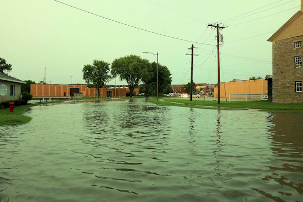
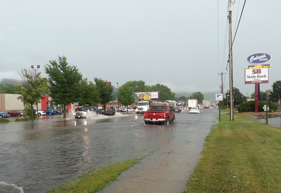
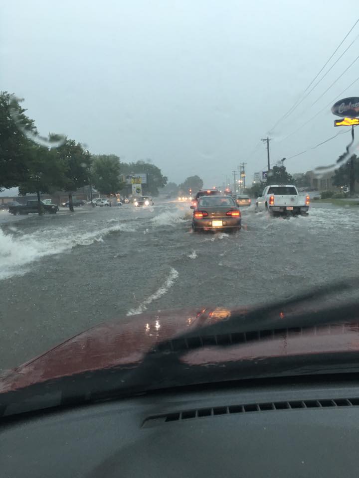
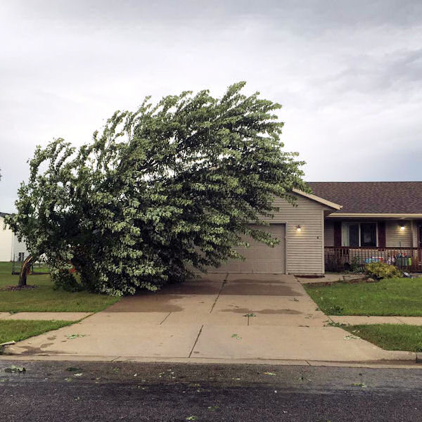
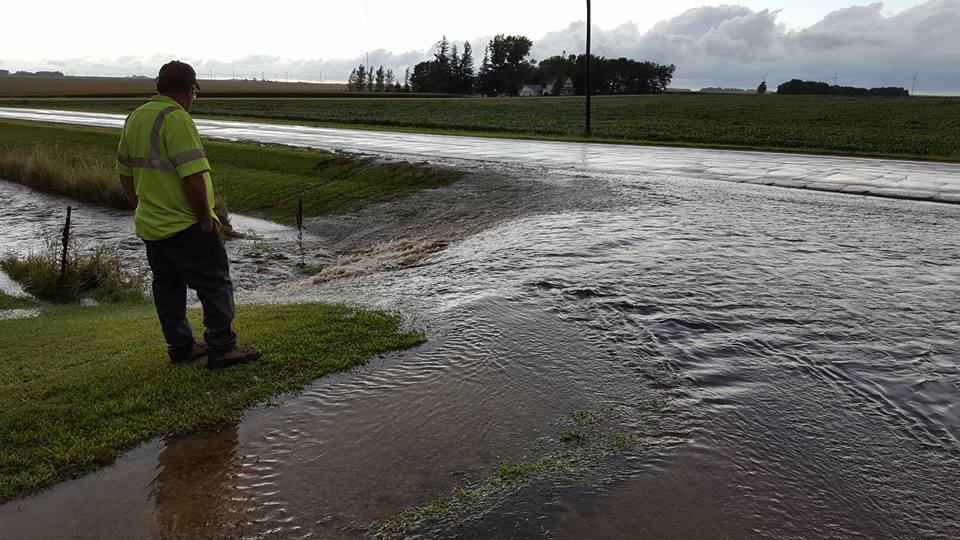
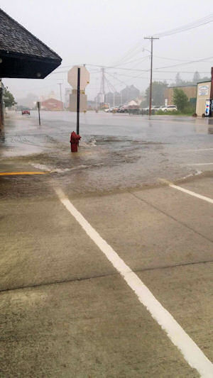
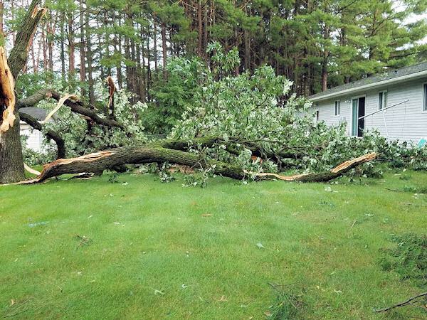
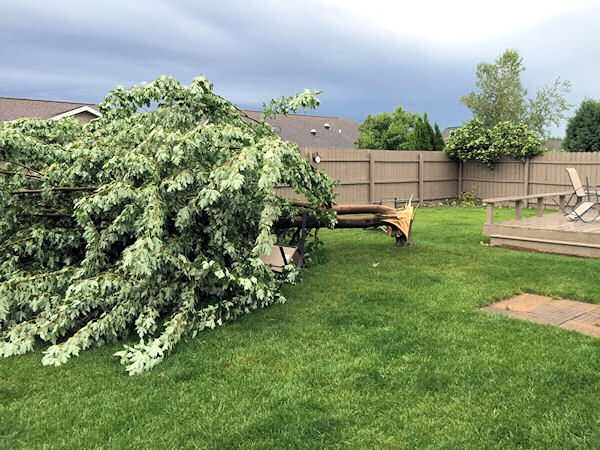
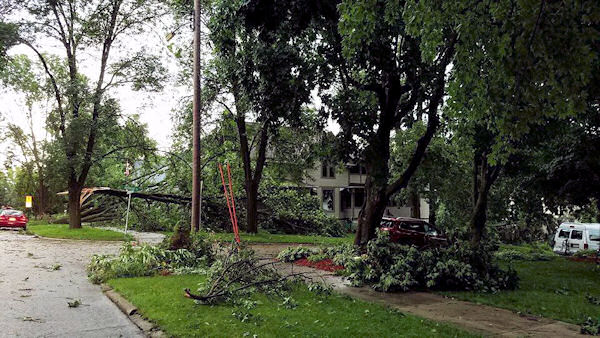
Several clusters of strong to severe thunderstorms impacted parts of the area on Thursday, August 4th. During the afternoon and into the early evening, severe storms produced wind gusts up to 70 mph and torrential rains. Most of the wind damage was across west central Wisconsin and northeast Iowa. 1-2" per hour rainfall rates were common with the storms, resulting in urban flooding. |
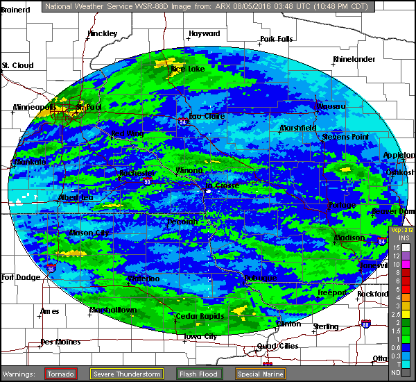
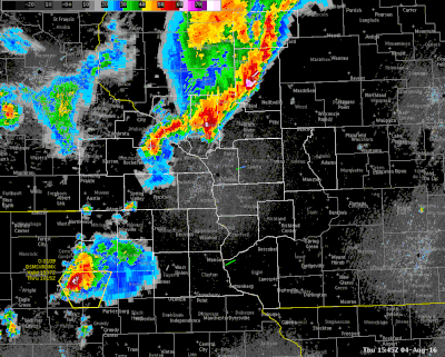 Radar loop from around 10 a.m. to 8 p.m., with warnings overlaid in yellow. |
Wind:
Here are some of the peak wind gusts as storms moved through on Thursday, Aug.4th.
Wind Reports
Public Information Statement
National Weather Service La Crosse WI
837 PM CDT Thu Aug 4 2016

...Wind Reports...

Location                     Speed     Time/Date       Lat/Lon

...Iowa...

...Chickasaw County...
2 N Ionia                    29 MPH    0540 PM 08/04   43.07N/92.46W

...Fayette County...
Fayette-CWOP                 42 MPH    0640 PM 08/04   42.84N/91.80W
Oelwein Municipal Airport    33 MPH    0635 PM 08/04   42.68N/91.97W

...Floyd County...
Charles City Airport         45 MPH    0535 PM 08/04   43.07N/92.61W

...Howard County...
3 NE Riceville               43 MPH    0523 PM 08/04   43.40N/92.50W

...Winneshiek County...
Decorah Municipal Airport    63 MPH    0615 PM 08/04   43.28N/91.74W
5 NW Frankville              56 MPH    0610 PM 08/04   43.25N/91.70W

...Minnesota...

...Dodge County...
2 E Kasson                   49 MPH    0135 PM 08/04   44.02N/92.71W
Dodge Center Airport         26 MPH    0134 PM 08/04   44.02N/92.83W

...Fillmore County...
2 ESE Canton                 34 MPH    0600 PM 08/04   43.51N/91.88W
Preston Airport              25 MPH    0533 PM 08/04   43.68N/92.18W

...Houston County...
4 SSE Mound Prairie          27 MPH    0330 PM 08/04   43.72N/91.44W

...Mower County...
1 ENE Dexter                 40 MPH    0505 PM 08/04   43.73N/92.68W
Austin Municipal Airport     32 MPH    0455 PM 08/04   43.66N/92.93W

...Olmsted County...
Mayo Helipad                 41 MPH    0154 PM 08/04   44.02N/92.48W
Rochester International Airp 36 MPH    0159 PM 08/04   43.91N/92.50W
2 SE Eyota                   32 MPH    0215 PM 08/04   43.96N/92.21W
2 SE Douglas                 27 MPH    0131 PM 08/04   44.08N/92.55W
Byron                        27 MPH    0137 PM 08/04   44.04N/92.64W

...Winona County...
1 E Ridgeway                 44 MPH    0305 PM 08/04   43.91N/91.54W

...Wisconsin...

...Grant County...
Platteville Municipal Airpor 45 MPH    0755 PM 08/04   42.69N/90.44W
1 ENE Boscobel               27 MPH    0603 PM 08/04   43.15N/90.68W
Boscobel Airport             25 MPH    0730 PM 08/04   43.16N/90.67W

...Jackson County...
Black River Falls Area Airpo 28 MPH    1135 AM 08/04   44.25N/90.86W

...Juneau County...
Necedah                      31 MPH    0148 PM 08/04   44.03N/90.08W
Volk Field                   31 MPH    1250 PM 08/04   43.94N/90.25W

...La Crosse County...
La Crosse Regional Airport   53 MPH    0318 PM 08/04   43.88N/91.26W
3 W Saint Joseph             39 MPH    0335 PM 08/04   43.78N/91.10W

...Taylor County...
Medford Airport              28 MPH    1115 AM 08/04   45.10N/90.30W

...Vernon County...
Viroqua Municipal Airport    35 MPH    0415 PM 08/04   43.58N/90.90W

Observations are collected from a variety of sources with varying
equipment and exposures. Not all data listed are considered official.

$$
.
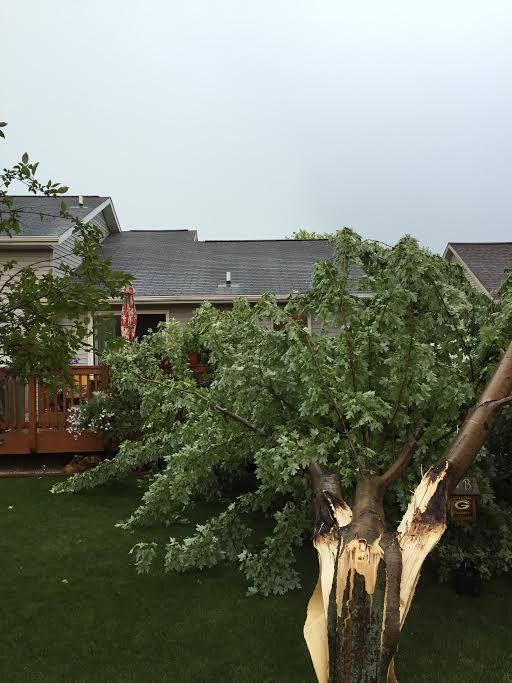
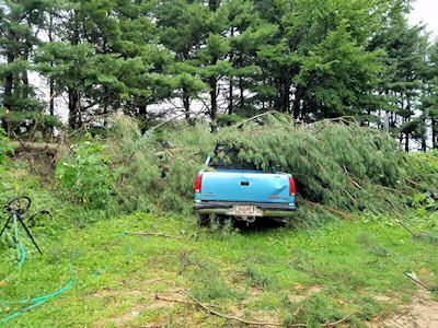
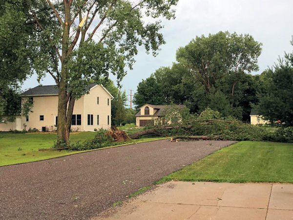
Photos:
Damage
 |
 |
 |
 |
| Holmen, WI (Dave Schmidt) |
Wonewoc, WI (Christopher Lange) |
Decorah, IA (KWWL-TV) |
Decorah, IA (KWWL-TV) |
 |
 |
 |
 |
| La Crosse, WI (Cindy W.) |
La Crosse, WI (Sue Lacoste) |
Holmen, WI (Kristen Schams) |
Holmen, WI (Belinda) |
 |
 |
 |
 |
| Ostrander, MN (Colleen Marks) |
Spring Valley, MN (Mike Niemeyer) |
Holmen, WI (Joni Wittwer) |
Holmen, WI (Katie Cox) |
 |
 |
||
| Decorah, IA (Melissa) |
Holmen, WI (Photo by Missy Hahm) |
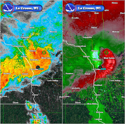
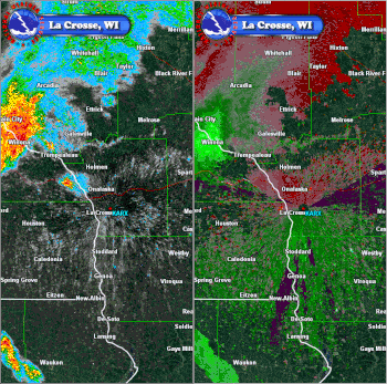
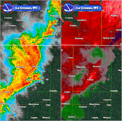
Radar:
 |
 |
| West Salem & La Crosse WI: Reflectivity and Velocity wind imagery from 3:28 p.m. |
West Salem & La Crosse, WI: Reflectivity and Velocity Loop from 2:45 p.m. to 4:00 p.m. |
 |
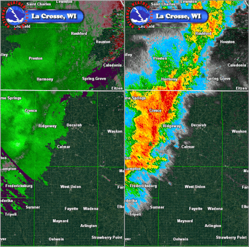 |
| Decorah, IA: Reflectivity and Velocity wind imagery from 6:02 p.m. |
Decorah, IA: Velocity and Reflectivity Loop from 5:46 pm to 6:30 pm. Note the expanding "blow echo" in the reflectivity. Also, the reduction in "intensity" of the reflectivity behind this bow is indicative of strong winds a loft pushing to the surface. |
Storm Reports
PRELIMINARY LOCAL STORM REPORT...SUMMARY
NATIONAL WEATHER SERVICE LA CROSSE WI
614 PM CDT FRI AUG 5 2016

..TIME...   ...EVENT...      ...CITY LOCATION...     ...LAT.LON...
..DATE...   ....MAG....      ..COUNTY LOCATION..ST.. ...SOURCE....
            ..REMARKS..

0159 PM     TSTM WND GST     4 N STEWARTVILLE        43.91N 92.50W
08/04/2016  M36 MPH          OLMSTED            MN   ASOS

            ASOS STATION ROCHESTER INTERNATIONAL AIRPORT
            /RST/.

0230 PM     HEAVY RAIN       2 ESE ROCHESTER         44.00N 92.45W
08/04/2016  U1.40 INCH       OLMSTED            MN   PUBLIC

            1.4 INCHES OF RAIN IN 45 MINUTES BY MAYO
            HIGH SCHOOL. REPORT RELAYED BY MEDIA.

0300 PM     TSTM WND GST     HOLMEN                  43.96N 91.26W
08/04/2016  M71 MPH          LA CROSSE          WI   AMATEUR RADIO

            REPORTED FROM K9WKW .

0308 PM     HAIL             4 SW DORCHESTER         43.43N 91.57W
08/04/2016  E0.50 INCH       ALLAMAKEE          IA   PUBLIC


0315 PM     TSTM WND GST     2 SSE HOLMEN            43.93N 91.24W
08/04/2016  E50 MPH          LA CROSSE          WI   NWS EMPLOYEE

            .

0320 PM     TSTM WND DMG     1 NW HOLMEN             43.97N 91.27W
08/04/2016                   LA CROSSE          WI   NWS EMPLOYEE

            2 TREES AND AT LEAST HALF A DOZEN LARGE
            BRANCHES DOWN. WINDS ESTIMATED AROUND 50
            MPH. TIME ESTIMATED FROM RADAR.

0323 PM     TSTM WND GST     2 ESE LA CROSSE         43.81N 91.19W
08/04/2016  M60 MPH          LA CROSSE          WI   NWS EMPLOYEE

            MEASURED AT THE NWS OFFICE. SEVERAL BRANCHES
            DOWN.

0325 PM     HEAVY RAIN       1 WSW WEST SALEM        43.90N 91.10W
08/04/2016  M2.12 INCH       LA CROSSE          WI   NWS EMPLOYEE

            STORM TOTAL.

0325 PM     TSTM WND DMG     2 S HOLMEN              43.94N 91.26W
08/04/2016                   LA CROSSE          WI   NWS EMPLOYEE

            40 FOOT AUTUMN BLAZE SNAPPED AND FELL IN
            YARD.

0325 PM     HEAVY RAIN       1 W WEST SALEM          43.90N 91.10W
08/04/2016  M2.12 INCH       LA CROSSE          WI   NWS EMPLOYEE

            STORM TOTAL.

0325 PM     TSTM WND GST     2 S HOLMEN              43.94N 91.26W
08/04/2016  E55 MPH          LA CROSSE          WI   NWS EMPLOYEE

            .

0325 PM     TSTM WND DMG     2 ESE BRICE PRAIRIE     43.93N 91.26W
08/04/2016                   LA CROSSE          WI   NWS EMPLOYEE

            40-FOOT TALL AUTUMN BLAZE TREE SNAPPED.
            ESTIMATED GUST AROUND 55 MPH.

0330 PM     TSTM WND GST     1 SW LA CROSSE          43.82N 91.25W
08/04/2016  E60 MPH          LA CROSSE          WI   LAW ENFORCEMENT

            .

0330 PM     TSTM WND DMG     WEST SALEM              43.90N 91.08W
08/04/2016                   LA CROSSE          WI   PUBLIC

            TREE SPLIT IN HALF BLOCKING SIDEWALK AND
            PART OF STREET ACROSS FROM THE LA CROSSE
            COUNTY FAIRGROUNDS.

0330 PM     TSTM WND GST     2 ESE BRICE PRAIRIE     43.93N 91.26W
08/04/2016  E60 MPH          LA CROSSE          WI   NWS EMPLOYEE

            LARGE TREE LIMBS/BRANCHES DOWN.

0330 PM     TSTM WND GST     2 SSW WEST SALEM        43.87N 91.10W
08/04/2016  E60 MPH          LA CROSSE          WI   NWS EMPLOYEE

            LARGE TREES DOWN ALONG COUNTRY ROAD M.

0330 PM     TSTM WND GST     LA CROSSE               43.83N 91.23W
08/04/2016  E60 MPH          LA CROSSE          WI   LAW ENFORCEMENT

            ESTIMATED 60 MPH GUSTS, SEVERAL SMALL TREES
            DOWN. MINOR STREET FLOODING.

0330 PM     TSTM WND DMG     HOLMEN                  43.96N 91.26W
08/04/2016                   LA CROSSE          WI   NWS EMPLOYEE

            LOTS OF TREE DAMAGE.

0330 PM     TSTM WND DMG     2 SSE HOLMEN            43.93N 91.24W
08/04/2016                   LA CROSSE          WI   NWS EMPLOYEE

            LARGE TREE LIMBS/BRANCHES DOWN (>=2") EST.
            WIND GUST OF 60 MPH TOOK DOWN SECTIONS OF
            TREES; PONDING OF WATER.

0339 PM     TSTM WND GST     2 ESE BRICE PRAIRIE     43.93N 91.26W
08/04/2016  E50 MPH          LA CROSSE          WI   NWS EMPLOYEE

            45 TO 50 MPH WIND GUSTS WITH SMALL BRANCHES
            DOWN.

0355 PM     TSTM WND DMG     CASHTON                 43.74N 90.78W
08/04/2016                   MONROE             WI   TRAINED SPOTTER

            DAMAGE TO CORN FIELDS IN THE CASHTON AREA.

0400 PM     TSTM WND GST     4 SSE LA CROSSE         43.77N 91.22W
08/04/2016  M39 MPH          LA CROSSE          WI   TRAINED SPOTTER

            .

0400 PM     HEAVY RAIN       4 SSE LA CROSSE         43.77N 91.22W
08/04/2016  U2.85 INCH       LA CROSSE          WI   TRAINED SPOTTER

            .

0400 PM     FLOOD            LA CROSSE               43.83N 91.23W
08/04/2016                   LA CROSSE          WI   AMATEUR RADIO

            1.5 TO 1.75 INCHES OF RAIN IN LESS THAN ONE
            HOUR CAUSING STREET FLOODING. MANY TREE
            LIMBS DOWN.

0400 PM     FLASH FLOOD      1 NNW LA CROSSE         43.84N 91.24W
08/04/2016                   LA CROSSE          WI   PUBLIC

             LIBERTY ST IMPASSABLE NEAR MADISON.

0400 PM     FLASH FLOOD      1 WNW LA CROSSE         43.83N 91.25W
08/04/2016                   LA CROSSE          WI   PUBLIC

            ROSE ST AND COPELAND UNDER WATER FROM
            MONITOR ST TO CAUSEWAY.

0407 PM     FLOOD            4 S LA CROSSE           43.77N 91.23W
08/04/2016                   LA CROSSE          WI   TRAINED SPOTTER

            ESTIMATED AT LEAST 6 INCHES OF WATER ON
            MORMON COULEE RD BY KWIK TRIP AND WALMART.

0410 PM     TSTM WND GST     VIROQUA                 43.56N 90.89W
08/04/2016  M47 MPH          VERNON             WI   TRAINED SPOTTER


0430 PM     HEAVY RAIN       5 WNW OSTRANDER         43.64N 92.52W
08/04/2016  M3.71 INCH       MOWER              MN   MESONET


0430 PM     TSTM WND GST     3 NE MOUND PRAIRIE      43.81N 91.42W
08/04/2016  E45 MPH          HOUSTON            MN   PUBLIC

            .

0430 PM     HEAVY RAIN       3 NE MOUND PRAIRIE      43.81N 91.42W
08/04/2016  M1.44 INCH       HOUSTON            MN   PUBLIC

            .

0435 PM     TSTM WND DMG     1 S UNION CENTER        43.67N 90.27W
08/04/2016                   JUNEAU             WI   PUBLIC

            MULTIPLE LARGE TREES AND POWER LINES DOWN.
            ONE TREE FELL ON AND DAMAGED A PICKUP TRUCK.

0500 PM     HEAVY RAIN       1 NW MOUNT ZION         43.27N 90.75W
08/04/2016  M1.45 INCH       CRAWFORD           WI   TRAINED SPOTTER

            .

0500 PM     HEAVY RAIN       3 W ELON                43.27N 91.38W
08/04/2016  M1.15 INCH       ALLAMAKEE          IA   PUBLIC

            .

0500 PM     HEAVY RAIN       6 S MUSCODA             43.10N 90.43W
08/04/2016  M1.20 INCH       GRANT              WI   PUBLIC

            .

0500 PM     HEAVY RAIN       4 S BLUE RIVER          43.13N 90.57W
08/04/2016  M1.10 INCH       GRANT              WI   PUBLIC

            .

0500 PM     HEAVY RAIN       BANGOR                  43.89N 90.99W
08/04/2016  M2.03 INCH       LA CROSSE          WI   PUBLIC

            .

0511 PM     HEAVY RAIN       KENDALL                 43.79N 90.37W
08/04/2016  M1.70 INCH       MONROE             WI   PUBLIC

            REPORT FROM SOCIAL MEDIA.

0515 PM     HEAVY RAIN       ELROY                   43.74N 90.27W
08/04/2016  M1.25 INCH       JUNEAU             WI   PUBLIC

            REPORT FROM SOCIAL MEDIA.

0523 PM     TSTM WND GST     4 NE RICEVILLE          43.40N 92.50W
08/04/2016  M43 MPH          HOWARD             IA   MESONET

            MESONET STATION 3 NE RICEVILLE /E4652/.

0523 PM     TSTM WND GST     4 NE RICEVILLE          43.40N 92.50W
08/04/2016  M43 MPH          HOWARD             IA   MESONET

            MESONET STATION 3 NE RICEVILLE /E4652/.

0530 PM     TSTM WND DMG     2 N KENDALLVILLE        43.47N 92.04W
08/04/2016                   WINNESHIEK         IA   PUBLIC

            SEVERAL LARGE TREES DOWN AND SOME DAMAGE TO
            STRUCTURES AND A BIN. TIME ESTIMATED FROM
            RADAR.

0535 PM     TSTM WND GST     3 E CHARLES CITY        43.07N 92.61W
08/04/2016  M45 MPH          FLOYD              IA   AWOS

            AWOS STATION CHARLES CITY AIRPORT /CCY/.

0535 PM     TSTM WND GST     3 E CHARLES CITY        43.07N 92.61W
08/04/2016  M45 MPH          FLOYD              IA   AWOS

            AWOS STATION CHARLES CITY AIRPORT /CCY/.

0600 PM     HEAVY RAIN       WABASHA                 44.37N 92.05W
08/04/2016  U1.60 INCH       WABASHA            MN   PUBLIC

            STORM TOTAL.

0608 PM     TSTM WND DMG     DECORAH                 43.31N 91.79W
08/04/2016                   WINNESHIEK         IA   LAW ENFORCEMENT

            NUMEROUS TREES DOWN IN DECHORAH.

0610 PM     TSTM WND GST     6 NW FRANKVILLE         43.25N 91.70W
08/04/2016  M56 MPH          WINNESHIEK         IA   MESONET

            MESONET STATION 5 NW FRANKVILLE /RDCI4/.

0610 PM     TSTM WND GST     6 NW FRANKVILLE         43.25N 91.70W
08/04/2016  M56 MPH          WINNESHIEK         IA   MESONET

            MESONET STATION 5 NW FRANKVILLE /RDCI4/.

0615 PM     TSTM WND GST     3 SE DECORAH            43.27N 91.75W
08/04/2016  M63 MPH          WINNESHIEK         IA   AWOS

            WIND GUST MEASURED BY AWOS AT DECORAH
            AIRPORT.

0640 PM     TSTM WND GST     FAYETTE                 42.84N 91.80W
08/04/2016  M42 MPH          FAYETTE            IA   MESONET

            MESONET STATION FAYETTE-CWOP /E2110/.

0640 PM     TSTM WND GST     FAYETTE                 42.84N 91.80W
08/04/2016  M42 MPH          FAYETTE            IA   MESONET

            MESONET STATION FAYETTE-CWOP /E2110/.

0643 PM     HEAVY RAIN       3 S WINONA              44.01N 91.66W
08/04/2016  M1.70 INCH       WINONA             MN   PUBLIC

            STORM TOTAL.

0645 PM     HEAVY RAIN       2 E GALESVILLE          44.09N 91.31W
08/04/2016  M1.77 INCH       TREMPEALEAU        WI   PUBLIC

            .

0645 PM     HEAVY RAIN       2 ENE GALESVILLE        44.10N 91.32W
08/04/2016  M1.77 INCH       TREMPEALEAU        WI   PUBLIC

            1.77 INCHES OF RAIN IN 4 HOURS.

0705 PM     TSTM WND GST     EDGEWOOD                42.65N 91.40W
08/04/2016  M43 MPH          CLAYTON            IA   TRAINED SPOTTER


0738 PM     HEAVY RAIN       3 NNW FRENCHVILLE       44.19N 91.35W
08/04/2016  M1.91 INCH       TREMPEALEAU        WI   CO-OP OBSERVER

            .

0738 PM     HEAVY RAIN       3 NNW FRENCHVILLE       44.19N 91.35W
08/04/2016  M1.91 INCH       TREMPEALEAU        WI   CO-OP OBSERVER

            .

0740 PM     TSTM WND GST     5 NNE BURTON            42.79N 90.78W
08/04/2016  E45 MPH          GRANT              WI   PUBLIC


0745 PM     TSTM WND GST     DICKEYVILLE             42.63N 90.59W
08/04/2016  E55 MPH          GRANT              WI   LAW ENFORCEMENT

            WIND GUSTS ESTIMATED AT 45-55 MPH.

0745 PM     TSTM WND DMG     POTOSI                  42.69N 90.71W
08/04/2016                   GRANT              WI   LAW ENFORCEMENT

            POWER LINES DOWN.

0755 PM     TSTM WND GST     3 SSE PLATTEVILLE       42.70N 90.45W
08/04/2016  M45 MPH          GRANT              WI   AWOS


0800 PM     HEAVY RAIN       1 WSW WEST SALEM        43.90N 91.10W
08/04/2016  M1.00 INCH       LA CROSSE          WI   NWS EMPLOYEE

            .

0805 PM     TSTM WND DMG     HAZEL GREEN             42.53N 90.44W
08/04/2016                   GRANT              WI   PUBLIC

            SMALL TREE LIMBS DOWN.

0805 PM     TSTM WND DMG     HAZEL GREEN             42.53N 90.44W
08/04/2016                   GRANT              WI   TRAINED SPOTTER

            SMALL TREE LIMBS UP TO 2" IN DIAMETER .

0900 PM     HEAVY RAIN       3 N WOODMAN             43.14N 90.80W
08/04/2016  M2.10 INCH       CRAWFORD           WI   CO-OP OBSERVER

            2.1 INCHES OF RAIN SINCE 4 PM.


&&

$$

NWS LA CROSSE WI
.
Rain Reports
Public Information Statement
National Weather Service La Crosse WI
826 AM CDT Fri Aug 5 2016

...Rainfall Reports...

Location                     Amount    Time/Date       Lat/Lon

...Iowa...

...Allamakee County...
3 S Dorchester               1.60 in   0800 AM 08/05   43.42N/91.51W
3 SE Waterville              1.07 in   0807 AM 08/05   43.17N/91.24W
4 ENE Watson                 1.02 in   0745 AM 08/05   43.11N/91.26W

...Chickasaw County...
Ionia 2W                     1.63 in   0745 AM 08/05   43.03N/92.50W
New Hampton                  1.37 in   0700 AM 08/05   43.06N/92.32W

...Clayton County...
Monona WWTP                  2.35 in   0700 AM 08/05   43.04N/91.40W
Volga 1NE                    1.42 in   0600 AM 08/05   42.81N/91.52W
Littleport                   0.89 in   0745 AM 08/05   42.75N/91.37W
Elkader Turkey River         0.80 in   0745 AM 08/05   42.84N/91.40W
Guttenberg Dam 10            0.76 in   0600 AM 08/05   42.78N/91.10W
Marquette-Bloody Run Creek   0.69 in   0800 AM 08/05   43.04N/91.21W
Mcgregor 2                   0.14 in   0745 AM 08/05   43.02N/91.17W

...Fayette County...
Waucoma                      1.56 in   0656 AM 08/05   43.06N/92.03W
1 ENE Alpha                  1.32 in   0700 AM 08/05   43.01N/92.03W
Waucoma 1WNW                 1.32 in   0700 AM 08/05   43.06N/92.05W
Oelwein Municipal Airport    1.28 in   0655 AM 08/05   42.68N/91.97W
Fayette                      1.26 in   0700 AM 08/05   42.85N/91.82W
Eldorado                     1.02 in   0745 AM 08/05   43.05N/91.81W

...Floyd County...
Nashua 2sw                   2.15 in   0700 AM 08/05   42.94N/92.57W
Charles City                 1.74 in   0700 AM 08/05   43.06N/92.67W
Charles City Airport         1.50 in   0655 AM 08/05   43.07N/92.61W
Charles City-Cedar River     1.30 in   0730 AM 08/05   43.06N/92.67W
Nora Springs 2.4 SSE         1.10 in   0700 AM 08/05   43.11N/92.99W

...Howard County...
Cresco 1NE                   1.61 in   0700 AM 08/05   43.39N/92.09W
3 NE Riceville               1.32 in   0810 AM 08/05   43.40N/92.50W
Elma                         0.75 in   0700 AM 08/05   43.24N/92.44W

...Mitchell County...
St Ansgar                    0.24 in   0630 AM 08/05   43.38N/92.92W
Saint Ansgar                 0.12 in   0810 AM 08/05   43.38N/92.92W

...Winneshiek County...
Decorah Municipal Airport    1.31 in   0655 AM 08/05   43.28N/91.74W
Bluffton                     0.94 in   0745 AM 08/05   43.41N/91.90W
7 ENE Decorah                0.85 in   0700 AM 08/05   43.34N/91.64W
5 ESE Decorah                0.79 in   0700 AM 08/05   43.26N/91.70W

...Minnesota...

...Dodge County...
Dodge Center Airport         1.18 in   0654 AM 08/05   44.02N/92.83W
2 NE Kasson                  0.94 in   0600 AM 08/05   44.05N/92.72W
Hayfield                     0.15 in   0807 AM 08/05   43.89N/92.85W

...Fillmore County...
Spring Valley 3sw            2.55 in   0700 AM 08/05   43.66N/92.41W
Spring Valley 3E             1.69 in   0700 AM 08/05   43.68N/92.33W
Chatfield                    1.63 in   0700 AM 08/05   43.84N/92.20W
Fillmore                     1.48 in   0730 AM 08/05   43.76N/92.27W
Whalan 3.3 SSE               1.43 in   0700 AM 08/05   43.69N/91.90W
Lanesboro-Root River         1.40 in   0730 AM 08/05   43.72N/91.98W
Pilot Mound-Root River       1.40 in   0800 AM 08/05   43.78N/92.03W
Preston 6s                   1.37 in   0630 AM 08/05   43.59N/92.11W
Lanesboro 2NE                1.37 in   0700 AM 08/05   43.73N/91.94W
3 NE Preston                 1.32 in   0700 AM 08/05   43.71N/92.05W
Mabel                        1.31 in   0630 AM 08/05   43.52N/91.76W
Preston                      1.05 in   0806 AM 08/05   43.67N/92.07W
Preston Airport              1.02 in   0653 AM 08/05   43.68N/92.18W

...Houston County...
Hokah WWTP                   1.50 in   0700 AM 08/05   43.76N/91.35W
1 NNW La Crescent            1.45 in   0700 AM 08/05   43.83N/91.31W
Houston 7sw                  1.40 in   0630 AM 08/05   43.70N/91.67W
Caledonia                    1.37 in   0700 AM 08/05   43.63N/91.50W
Mound Prairie                1.14 in   0745 AM 08/05   43.78N/91.45W
Houston                      1.00 in   0745 AM 08/05   43.77N/91.57W

...Mower County...
Ostrander 5wnw               3.71 in   0630 AM 08/05   43.63N/92.53W
Ostrander 5.1 WNW            3.04 in   0700 AM 08/05   43.65N/92.52W
Austin 3 NW - Turtle Creek   0.92 in   0730 AM 08/05   43.65N/92.98W
Austin 3S                    0.64 in   0800 AM 08/05   43.64N/92.97W
Austin 2NE-Dobbins Creek     0.52 in   0730 AM 08/05   43.67N/92.95W
Austin Municipal Airport     0.42 in   0655 AM 08/05   43.66N/92.93W
Lansing-Cedar River          0.38 in   0730 AM 08/05   43.75N/92.95W

...Olmsted County...
1 W Chester                  1.53 in   0630 AM 08/05   44.00N/92.38W
Rochester-Beltline           1.43 in   0730 AM 08/05   44.01N/92.47W
2 ENE Rochester              1.34 in   0730 AM 08/05   44.03N/92.43W
Elgin 5SE                    1.28 in   0730 AM 08/05   44.01N/92.11W
2 NE Rochester               1.25 in   0600 AM 08/05   44.04N/92.44W
Rochester-Beltline Bear Cree 1.19 in   0730 AM 08/05   44.01N/92.45W
Rochester-Cascade Creek      1.19 in   0730 AM 08/05   44.03N/92.47W
Rochester International Airp 1.09 in   0654 AM 08/05   43.91N/92.50W
Elgin 2ssw                   1.06 in   0700 AM 08/05   44.10N/92.27W
2 NE Rochester               1.02 in   0807 AM 08/05   44.04N/92.44W
Mayo Helipad                 0.96 in   0654 AM 08/05   44.02N/92.48W
3 N Rochester                0.93 in   0715 AM 08/05   44.06N/92.47W
Rochester 3W                 0.91 in   0730 AM 08/05   44.02N/92.53W
3 NE Rochester               0.90 in   0810 AM 08/05   44.05N/92.45W
4 ESE Douglas                0.89 in   0803 AM 08/05   44.09N/92.49W
Eyota 2NE                    0.88 in   0730 AM 08/05   44.01N/92.20W
3 ESE Douglas                0.87 in   0805 AM 08/05   44.09N/92.51W
4 NNW Rochester              0.82 in   0700 AM 08/05   44.07N/92.49W
Byron                        0.82 in   0808 AM 08/05   44.03N/92.66W
Byron                        0.79 in   0809 AM 08/05   44.04N/92.64W
2 W High Forest              0.74 in   0500 AM 08/05   43.85N/92.59W
Oronoco 1W                   0.74 in   0730 AM 08/05   44.17N/92.55W
2 SE Douglas                 0.72 in   0803 AM 08/05   44.08N/92.55W
Pine Island 1S               0.62 in   0800 AM 08/05   44.19N/92.65W
Elba 4.7 SW                  0.59 in   0300 PM 08/04   44.04N/92.09W
3 SW Hammond                 0.55 in   0802 AM 08/05   44.18N/92.41W
Byron 4 North                0.52 in   0700 AM 08/05   44.09N/92.64W
Oxbow Park Alert Gage        0.48 in   0800 AM 08/05   44.09N/92.64W
Oronoco                      0.45 in   0730 AM 08/05   44.16N/92.54W

...Wabasha County...
Plainview                    1.31 in   0806 AM 08/05   44.17N/92.17W
Mazeppa 3ESE                 1.02 in   0730 AM 08/05   44.26N/92.49W
Wabasha                      0.76 in   0700 AM 08/05   44.38N/92.05W
2 NNW Zumbro Falls           0.75 in   0748 AM 08/05   44.32N/92.44W
Lake City                    0.71 in   0809 AM 08/05   44.45N/92.27W
Kellogg-Zumbro River         0.53 in   0800 AM 08/05   44.32N/92.00W

...Winona County...
Winona Municipal Airport     2.07 in   0653 AM 08/05   44.08N/91.71W
1 E Winona                   1.88 in   0805 AM 08/05   44.05N/91.63W
Winona Dam 5A                1.75 in   0610 AM 08/05   44.09N/91.67W
Dakota                       1.73 in   0715 AM 08/05   43.91N/91.36W
Minnesota City Dam 5         1.63 in   0700 AM 08/05   44.16N/91.81W
Beaver-White Water River     1.49 in   1245 AM 08/05   44.15N/92.00W
La Crescent Dam 7            1.35 in   0600 AM 08/05   43.87N/91.31W
Elba                         0.84 in   0745 AM 08/05   44.09N/92.03W
Whitewater State Park Group  0.58 in   0730 AM 08/05   44.06N/92.05W
Whitewater State Park        0.57 in   0730 AM 08/05   44.05N/92.05W

...Wisconsin...

...Adams County...
Monroe Center 1E             1.30 in   0700 AM 08/05   44.11N/89.92W
Petenwell Lake               0.37 in   0800 AM 08/05   44.08N/90.00W

...Buffalo County...
Mondovi                      1.18 in   0700 PM 08/04   44.56N/91.67W
Alma Dam 4                   0.73 in   0600 AM 08/05   44.33N/91.92W

...Clark County...
Owen 2N                      0.93 in   0800 AM 08/05   44.98N/90.55W
Neillsville 1W               0.47 in   0700 AM 08/05   44.56N/90.61W

...Crawford County...
Steuben 4SE                  2.15 in   0700 AM 08/05   43.13N/90.84W
Steuben                      1.87 in   0745 AM 08/05   43.18N/90.86W
Lynxville Dam 9              1.50 in   0600 AM 08/05   43.21N/91.10W
Gays Mills                   1.44 in   0800 AM 08/05   43.32N/90.85W
De Soto                      1.10 in   0806 AM 08/05   43.42N/91.19W
De Soto 1SE                  1.10 in   0500 AM 08/05   43.42N/91.19W
Prairie Du Chien             0.62 in   0700 AM 08/05   43.05N/91.13W
Prairie Du Chien  Airport    0.46 in   0655 AM 08/05   43.02N/91.12W

...Grant County...
Boscobel Airport             1.31 in   0653 AM 08/05   43.16N/90.67W
1 ENE Boscobel               1.25 in   0703 AM 08/05   43.15N/90.68W
Muscoda                      0.59 in   0745 AM 08/05   43.20N/90.44W
Cuba City                    0.47 in   0800 AM 08/05   42.60N/90.43W
Platteville Municipal Airpor 0.30 in   0655 AM 08/05   42.69N/90.44W

...Jackson County...
Black River Falls Area Airpo 1.96 in   0655 AM 08/05   44.25N/90.86W
1 E Black River Falls        1.92 in   0715 AM 08/05   44.30N/90.83W
Mather 3nw                   1.43 in   0700 AM 08/05   44.17N/90.35W

...Juneau County...
Mauston                      1.36 in   0807 AM 08/05   43.80N/90.07W
Volk Field                   1.31 in   0658 AM 08/05   43.94N/90.25W
Mauston Airport              1.28 in   0655 AM 08/05   43.84N/90.14W
Necedah 5 WNW                1.12 in   0810 AM 08/05   44.06N/90.17W
2 N Cloverdale               1.11 in   0810 AM 08/05   44.06N/90.17W
Necedah                      0.99 in   0748 AM 08/05   44.03N/90.08W
New Lisbon 4ene              0.89 in   0630 AM 08/05   43.91N/90.07W
Union Center                 0.73 in   0615 AM 08/05   43.68N/90.26W
2 WNW Dellwood               0.63 in   0740 AM 08/05   44.00N/89.99W

...La Crosse County...
West Salem 2w                2.37 in   0700 AM 08/05   43.90N/91.12W
Holmen 2s                    2.10 in   0700 AM 08/05   43.93N/91.25W
Onalaska 2n                  1.76 in   0700 AM 08/05   43.91N/91.23W
La Crosse Regional Airport   1.34 in   0653 AM 08/05   43.88N/91.26W
La Crosse Weather Office     1.30 in   0600 AM 08/05   43.82N/91.19W
WFO La Crosse                1.25 in   0620 AM 08/05   43.82N/91.19W

...Monroe County...
Kendall                      1.73 in   0755 AM 08/05   43.79N/90.37W
Cashton 3NNW                 1.47 in   0739 AM 08/05   43.79N/90.80W
Warrens 4WSW                 1.35 in   0700 AM 08/05   44.10N/90.59W
Tomah Ranger Station 2       1.17 in   0800 AM 08/05   43.97N/90.47W
Sparta                       1.04 in   0800 AM 08/05   43.94N/90.82W
Sparta/Fort McCoy Airport    0.87 in   0655 AM 08/05   43.96N/90.74W
2 E Cataract                 0.82 in   0808 AM 08/05   44.09N/90.79W
4 W Valley Junction          0.82 in   0645 AM 08/05   44.06N/90.50W
Four Corners                 0.52 in   0700 AM 08/05   44.09N/90.91W

...Richland County...
Richland Center 4N           1.54 in   0700 AM 08/05   43.40N/90.39W
3 NW Avoca                   1.16 in   0807 AM 08/05   43.23N/90.37W

...Taylor County...
Gad                          0.96 in   0700 AM 08/05   45.14N/90.20W
Chelsea                      0.67 in   0806 AM 08/05   45.30N/90.30W
3 NE Lublin                  0.59 in   0714 AM 08/05   45.11N/90.69W
Medford Airport              0.57 in   0655 AM 08/05   45.10N/90.30W

...Trempealeau County...
Trempealeau Dam 6            2.25 in   0600 AM 08/05   44.00N/91.44W
Ettrick 4WNW                 1.91 in   0737 AM 08/05   44.19N/91.34W
1 NW Trempealeau             1.83 in   0500 AM 08/05   44.03N/91.46W
Dodge                        0.43 in   0745 AM 08/05   44.13N/91.55W

...Vernon County...
Readstown                    1.83 in   0800 AM 08/05   43.45N/90.76W
Readstown 4NE                1.39 in   0700 AM 08/05   43.48N/90.69W
Westby 3ENE                  1.36 in   0700 AM 08/05   43.67N/90.81W
Viroqua Municipal Airport    1.14 in   0655 AM 08/05   43.58N/90.90W
Viroqua 0.8 ESE              1.13 in   0700 AM 08/05   43.55N/90.87W
Stoddard                     1.08 in   0700 AM 08/05   43.66N/91.22W
Genoa Dam 8                  1.05 in   0600 AM 08/05   43.57N/91.23W
Ontario                      0.90 in   0700 AM 08/05   43.72N/90.59W
Hillsboro WSW                0.66 in   0700 AM 08/05   43.65N/90.35W
Brownsville                  0.65 in   0745 AM 08/05   43.70N/91.27W

Observations are collected from a variety of sources with varying
equipment and exposures. Not all data listed are considered official.

$$
.
 |
Media use of NWS Web News Stories is encouraged! Please acknowledge the NWS as the source of any news information accessed from this site. |
|


 Weather Story
 Weather Map
 Local Radar