| During astronomical summer 2022 (June 21-September 21), average temperatures ranged from near-normal to 3°F warmer-than-normal across the Upper Mississippi River Valley. Monthly average temperatures ranged from 65°F at Medford Taylor County Airport, WI (AWOS) to 73.2°F near Oelwein, IA (COOP). The hottest temperature was 101°F near Theilman, MN (COOP) on June 21 and the coldest temperature was 39°F at Black River Falls, WI (RAWS) on September 13. |
 |
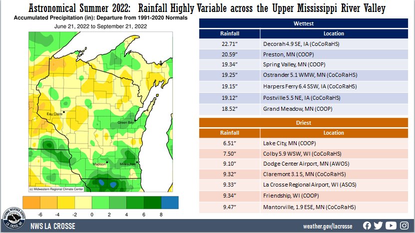
| Summer rainfall was highly variable across The Upper Mississippi River Valley. Rainfall anomalies ranged from 7” drier-than-normal to 8” wetter-than-normal across the region. Rain totals ranged from 6.51” at Lake City, MN (COOP) to 22.71” near Decorah, IA (CoCoRaHS). The greatest 1-day rainfall was 5.25" at Grand Meadow, MN (COOP). This rainfall fell from 7 AM on July 23 to 7 AM on July 24. |
 |
Below are the climate summaries for La Crosse, WI, and Rochester, MN.
La Crosse, WI
Tied for 14th Warmest Astronomical Summer in La Crosse WI
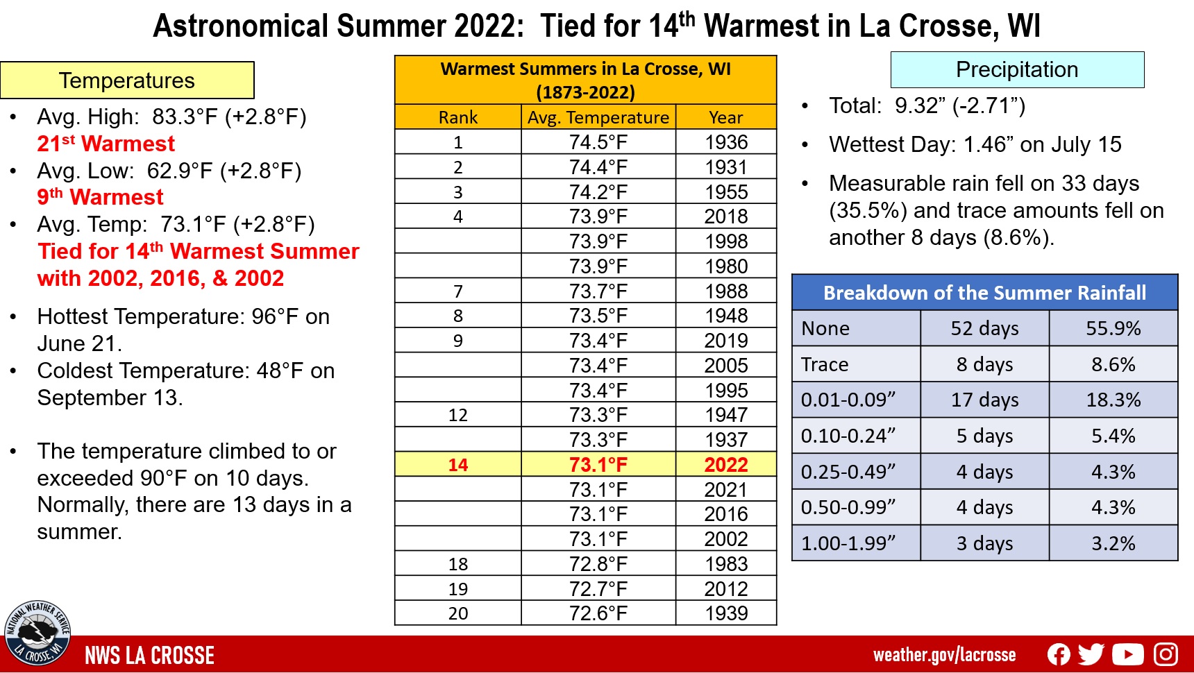
During the astronomical summer of 2022 (June 21 through September 21), it was warmer (tied for the 14th warmest with 2002, 2016, and 2021) and drier than normal at La Crosse Regional Airport. Records date back to 1873.
More details are listed below...
Temperatures - Tied for the 14th Warmest
- During astronomical summer, La Crosse Regional Airport had an average temperature of 73.1°F. This was 2.8°F warmer than the long-term average of 70.3°F.
- This was tied for the 14th warmest summer with 2002, 2016, and 2021).
- Since 1995, 25 out of 28 astronomical summers have been warmer than the long-term average. This includes the 4th warmest (tied 1998 and 2018), 9th warmest (tied 2005 and 2019), 14th warmest (2022), 14th warmest (tied 2002, 2016, 2021, and 2022), and 19th warmest (2012).
|
 |
- The table below lists the 20 warmest summers in La Crosse, WI.
Twenty Warmest
Astronomical Summers
in La Crosse WI
1873-2022
Average
Rank Temperature Year
---- ----------- ----
1 74.5°F 1936
2 74.4°F 1931
3 74.2°F 1955
4 73.9°F 2018
73.9°F 1998
73.9°F 1980
7 73.7°F 1988
8 73.5°F 1948
9 73.4°F 2019
73.4°F 2005
73.4°F 1995
12 73.3°F 1947
73.3°F 1937
14 73.1°F 2022
73.1°F 2021
73.1°F 2016
73.1°F 2002
18 72.8°F 1983
19 72.7°F 2012
20 72.6°F 1939
- The average maximum temperature was 83.3°F. This was 2.8°F warmer than the long-term average of 80.5°F. The was the 21st warmest.
- The average minimum temperature was 62.9°F. This was 2.8°F warmer than the long-term average of 60.1°F. This was the 9th warmest.
Other temperature tidbits this summer...
- The hottest temperature was 96°F on June 21 (the first day of summer).
- The coldest high temperature was 64°F on September 10.
- The warmest low temperature was 74°F on July 19 and August 7.
- The coldest low temperature was 48°F on September 13.
- The temperature climbed to or exceeded 90°F on 10 days. Normally, there are 13 days in the summer.
Rainfall - Drier-than-Average
- During the astronomical summer, La Crosse Regional Airport received 9.33" of rain which was 2.70" drier than the long-term normal of 12.03".
- The wettest calendar day occurred on July 15 when 1.46" of rain fell.
- Measurable rain fell on 33 days (35.5%) and trace amounts fell on another 8 days (8.6%).
​
- Here is a breakdown of the summer rain...
- None 52 days - 55.9%
- Trace 8 days - 8.6%
- 0.01-0.09 inches 17 days - 18.3%
- 0.10-0.24 inches 5 days - 5.4%
- 0.25-0.49 inches 4 days - 4.3%
- 0.50-0.99 inches 4 days - 4.3%
- 1.00-1.99 inches 3 days - 3.2%
- 2.00-2.99 inches 0 days - 0.0%
- 3.00 inches + 0 day - 0.0%
​Rochester, MN
Astronomical Summer was Wetter and Slightly Warmer than the Long-Term Average in Rochester MN
During the astronomical summer of 2022 (June 21 through September 21), it was wetter and slightly warmer than the long-term average at Rochester International Airport. Records date back to 1887.
More details are listed below...
Temperatures - Slightly Warmer than the Long-Term Average
- During astronomical summer, Rochester International Airport had an average temperature of 68.9°F. This was 0.8°F warmer than the long-term average of 68.1°F.
- The average maximum temperature was 79°F. This was 0.1°F cooler than the long-term average of 79.1°F.
- The average minimum temperature was 58.9°F. This was 1.8°F warmer than the long-term average of 57.1°F. This was the 19th warmest.
|
 |
Other temperature tidbits this summer...
- The hottest temperature was 91°F on June 23.
- The coldest high temperature was 65°F on September 10.
- The warmest low temperature was 69°F on July 5 and August 6.
- The coldest temperature was 47°F on September 11.
- The temperature climbed to or exceeded 90°F on 2 days. Normally, there are 9 days per summer.
Rainfall - 26th Wettest
- During the astronomical summer, Rochester International Airport received 13.95" of rain which was 1.96" wetter than the long-term normal of 11.99".
- 7 out of the last 9 summers have been wetter than the long-term normal. This includes the 3rd wettest (2019) and 6th wettest (2016).
- The wettest day occurred on July 23 when 3.09" of rain fell.
- Measurable rain fell on 28 days (30.1%) and trace amounts fell on another 9 days (9.7%).
- Here is a breakdown of the summer rain...
- None 56 days - 60.2%
- Trace 9 days - 9.7%
- 0.01-0.09 inches 10 days - 10.8%
- 0.10-0.24 inches 3 days - 3.2%
- 0.25-0.49 inches 7 days - 7.5%
- 0.50-0.99 inches 4 days - 4.3%
- 1.00-1.99 inches 3 days - 3.2%
- 2.00-2.99 inches 0 days - 0%
- 3.00 inches + 1 day - 1.1%
