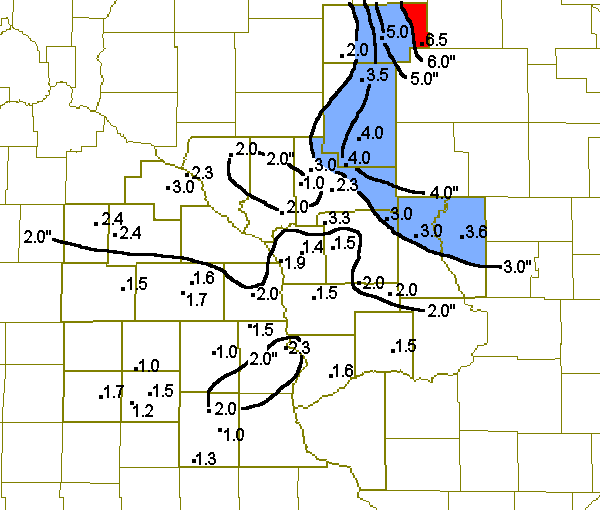
April 4, 2003 Snow Totals
A cold front moved across the upper Midwest on April 1st and brought a return to below normal temperatures to the region. By the 3rd, the front had become stationary across northern Illinois and central Iowa. Temperatures behind the front had fallen into the 30s and 40s. Two areas of low pressure moved out of Nebraska and Kansas and along the front during the 4th. Temperatures above the surface were still above freezing in some locations, so the first area of low pressure caused a wide variety of precipitation types to form. Snow, sleet and freezing drizzle were all reported. By the time the second low moved by the area, temperatures had cooled enough for snow to be the dominant precipitation type. Snowfall totals ranged from around an inch across northeast Iowa, southern Minnesota and southwest Wisconsin, up to 6 inches in central Wisconsin. Goodrich, Wisconsin in southeast Taylor county had the highest total with 6.5 inches.

Snow totals for April 4.
|
LOCATION |
COUNTY |
SNOWFALL |
| ...IOWA... | ||
| CHARLES CITY | FLOYD | 1.7 |
| DECORAH | WINNESHIEK | 1.0 |
| DORCHESTER | ALLAMAKEE | 1.5 |
| ELMA | HOWARD | 1.0 |
| FAYETTE | FAYETTE | 1.0 |
| IONIA | CHICKASAW | 1.2 |
| LANSING | ALLAMAKEE | 2.3 |
| NEW HAMPTON | CHICKASAW | 1.5 |
| OELWEIN | FAYETTE | 1.3 |
| WEST UNION | FAYETTE | 2.0 |
| ...MINNESOTA... | ||
| BYRON | OLMSTED | 2.4 |
| CALEDONIA | HOUSTON | 2.0 |
| GRAND MEADOW | MOWER | 1.5 |
| LANESBORO | FILLMORE | 1.6 |
| MANTORVILLE | DODGE | 2.4 |
| PRESTON | FILLMORE | 1.7 |
| THEILMAN | WABASHA | 3.0 |
| WABASHA | WABASHA | 2.3 |
| ...WISCONSIN... | ||
| BLACK RIVER FALLS | JACKSON | 2.3 |
| ETTRICK | TREMPEALEAU | 2.0 |
| FOUR CORNERS | MONROE | 3.3 |
| FRIENDSHIP | ADAMS | 3.6 |
| GAD | TAYLOR | 5.0 |
| GOODRICH | TAYLOR | 6.5 |
| HATFIELD | JACKSON | 4.0 |
| HILLSBORO | VERNON | 2.0 |
| HIXTON | JACKSON | 3.0 |
| LA CROSSE | LA CROSSE | 1.9 |
| LUBLIN | TAYLOR | 2.0 |
| MATHER | MONROE | 3.0 |
| MONDOVI 6S | BUFFALO | 2.0 |
| NECEDAH 2S | JUNEAU | 3.0 |
| NEILLSVILLE | CLARK | 4.0 |
| ONTARIO | VERNON | 2.0 |
| OWEN | CLARK | 3.5 |
| RICHLAND CENTER | RICHLAND | 1.5 |
| SPARTA | MONROE | 1.5 |
| STUEBEN | CRAWFORD | 1.6 |
| TAYLOR | JACKSON | 1.0 |
| WESTBY | VERNON | 1.5 |
| WEST SALEM | LA CROSSE | 1.4 |