| August 2010 |
|
|
|
|
|
|
|
|
|
|
|
|
|
|
|
|
|
|
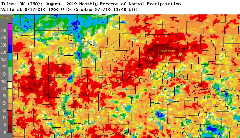
- Drought quickly developed across east central and southeast OK and northwest AR during August 2010. According to the Drought Monitor, locations along and southeast of Interstate 44 were experiencing moderate drought conditions by the end of the month.
|
|
|
- According to the Oklahoma Climatological Survey (OCS), east central OK ranked as the 5th driest August and southeast OK ranked as the 12th driest (northeast OK ranked as the 40th wettest) since records began in 1921.
|
- No rivers reached flood stage this month.
|
| Summer (Jun-Jul-Aug) 2010 |
|
|
|
|
- While afternoon temperatures and heat index values were hot this summer, it was actually the overnight low temperatures that had been exceptionally warm the entire summer across the area. high pressure dominated the Southern Plains and Southeastern U.S. during summer 2010, keeping a moist airmass in place over the region. The higher humidity levels kept temperatures from cooling much during the overnight hours, allowing for many consecutive days with minimum temperatures at or above 70°F. Find more information about this here.
|
|
|
| Outlook |
- The Climate Prediction Center (CPC) outlook for September 2010 (issued August 31, 2010) indicates a slightly enhanced chance for above average temperatures and equal chances for above, near, and below median precipitation. For the 3-month period Sep-Oct-Nov 2010, CPC is forecasting an enhanced chance for above average temperatures and equal chances for above, near, and below median precipitation (outlook issued August 19, 2010).
|
- Sea-surface temperatures in the equatorial Pacific indicate have decreased and are now indicating La Niña conditions. According to CPC, strong cooling in the equatorial Pacific over the last several months indicates that La Niña conditions are likely to strengthen and continue through winter 2010-2011. A La Niña Advisory was issued August 5, meaning that La Niña conditions are observed and expected to continue.
|
| |


