NFDRS Single Station Forecasts

This product measures wildfire danger at RAW Sites. NFDRS observations are taken once per day. NFDRS forecasts are not intended to be site specific, but an overview of the general fire danger. Effective fire suppression planning depends heavily on NFDRS, because it is an objective tool for predicting the difficulty of suppression a wild fire. The NWS role in NFDRS is forecasting weather input which, combined with customer input, allows NFDRS software to predict the next day's fire danger indices. Daily weather observations entered into NFDRS by the fire agencies form the basis of the forecast input by the NWS. Each NFDRS site is located at a spot which is representative of the terrain and fuel types dominant in that area.
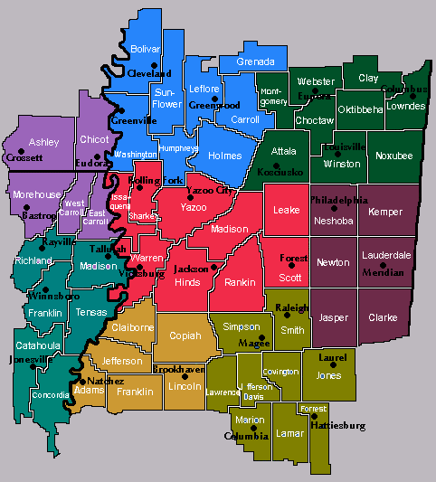
Here is the list of the following NFDRS stations in WFO Jackson's Forecast Area:
- 226102 - Bude Station in Lawrence County
- 225502 - Copiah Station in Copiah County
- 223301 - Delta Station in Sharkey County
- 224403 - Ridgeland Station in Madison County
- 227202 - Marion Station in Marion County
- 225101 - Bienville Station in Scott County
- 224101 - Noxubee NWR in Noxubee County
- 037403 - Felthensal NWR in Ashley County Arkansas
- 226502 - Covington Station in Covington County
- 223501 - Holmes Station in Holmes County
- 224201 - Warren Station in Warren County
- 225301 - Lauderdale Station in Lauderdale County
- 224601 - Neshoba Station in Neshoba County
Example of NFDRS Single Station Forecast
FWMJAN
FCST,226102,030514,13,9,85,55,5,4,SW,9,M,85,64,100,62,8,2,N
FCST,225502,030514,13,9,78,65,5,4,SW,9,M,80,64,100,67,8,3,N
FCST,223301,030514,13,9,73,84,5,4,SW,11,M,77,63,100,70,8,6,N
FCST,224403,030514,13,9,76,69,5,4,SW,9,M,78,62,100,70,8,4,N
FCST,227202,030514,13,9,85,58,5,4,SW,9,M,85,65,100,63,8,1,N
FCST,225101,030514,13,9,78,68,5,4,SW,9,M,80,62,100,67,8,4,N
FCST,224101,030514,13,9,78,67,5,4,SW,8,M,81,63,100,68,8,4,N
FCST,037403,030514,13,9,77,65,4,3,SW,9,M,82,67,100,69,7,3,N
FCST,226502,030514,13,9,77,65,4,3,SW,9,M,82,67,100,69,7,3,N
FCST,223501,030514,13,9,77,65,4,3,SW,9,M,82,67,100,69,7,3,N
FCST,224201,030514,13,9,77,65,4,3,SW,9,M,82,67,100,69,7,3,N
FCST,225301,030514,13,9,77,65,4,3,SW,9,M,82,67,100,69,7,3,N
FCST,224601,030514,13,9,77,65,4,3,SW,9,M,82,67,100,69,7,3,N
FCST,227401,030514,13,9,77,65,4,3,SW,9,M,82,67,100,69,7,3,N
Format for NFDRS forecast - FCST,226102,030514,13,2,83,65,1,3,S,11,M,83,68,100,65,0,0,N
- FCST - Forecast Point.
- 226102 - NFDRS Station ID(22 - State; 61 - County; 02 - Station ID).
- 030514 - Tomorrow's Forecast Date.
- 13 - Local LST for Tomorrow's Foreast (always 1300).
- 2 - Weather valid at 1300 LST Tomorrow - 0 = Clear; 1 = Scattered Clouds; 2 = Broken Clouds; 3 = Overcast Clouds; 4 = Foggy; 5 = Drizzle; 6 = Raining; 7 = Snowing; 8 = Showers at or near station; 9 = Thunderstorms.
- 83 - Current Temp at 1300.
- 65 - Current Relative Humidity at 1300.
- 1 - LAL1 Lightning Activity Level from 1400 to 2300 LST.
- 3 - LAL2 Lightning Activity Level from 2300 to 2300 LST (1 = none; 2 = isolated; 3 = few; 4 = scattered; 5 = numerous; 6 = which is high based storms out west, which we will not deal with in the south.
- S,11 - Wind & Windspeed valid at 1300 LST
- M - Missing 10 hr time lag fuel moisture (always missing).
- 83 - Maximum temperature for tomorrow.
- 68 - Minimum temperature for tomorrow.
- 100 - Maximum humidity for tomorrow.
- 65 - Minimum humidity for tomorrow.
- 0 - Precipitation Average Duration from 1400 to 0500 LST.
- 0 - Precipitation Average Duration from 2300 to 2300 LST.
- N - Y or N; This indicates whether liquid water will be on the fuels at 1300 LST. Use with CAUTION - a Y will reset all the indices to zero. We will keep the value at N in our product for all stations.
![]()