National Weather Service United States Department of Commerce

Storm Impacting the Northwest U.S.; Fire Weather Conditions in Southern California; Severe Weather in the South

A Pacific storm is bringing areas of low elevation rain, moderate to heavy mountain snow, and high winds to the Northwest. Strong Santa Ana winds and very dry conditions are producing elevated to critical fire weather conditions in southern California. Isolated strong to severe thunderstorms are possible through early Wednesday morning across parts of northeast Texas into western Tennessee. Read More >

November 28-29, 2016 Severe Weather


Event Summary

Two separate bouts of severe weather impacted a large portion of the ArkLaMiss region over a two day period in late November. The first event began on the afternoon of Monday, November 28th and ended around midnight on Tuesday, November 29th . A potent upper level low pressure system spinning over the Northern Plains caused a strong surface low pressure system to develop and rapidly race northeast from the Central Plains to the Great Lakes region. This resulted in a strong cold front racing east into and through the ArkLaMiss region. As it did so, it encountered a strongly wind-sheared and marginally unstable air mass over the area. This equated to a line of storms racing east across the ArkLaMiss, that downed numerous trees and powerlines across the area. Numerous trees were also reported down well ahead of the front due to widespread sustained gradient winds between 25-35 mph, gusting between 40-50 mph at times over the ArkLaMiss. After this cold front pushed through the region, it stalled near the central gulf coast Tuesday morning, aiding in setting the stage for the second bout of severe weather that would affect the region from Tuesday afternoon into the early morning hours of Wednesday, November 30th.

Another piece of upper level energy associated with the low pressure system aloft over the Northern Plains, approached the Southeast United States Tuesday afternoon. As this happened, it caused the front stalled south of the area to begin lifting north through the area as a warm front. As warm moist unstable air overspread the region from the south, both wind shear and forcing over the region became adequate, such that supercell thunderstorms began developing and moving northeast through the area. Numerous storms became severe and produced damaging wind gusts and large hail, primarily ranging from quarter to golfball size. Hen egg size hail was reported in Leake County, while baseball size hail was reported from storms in Sunflower and Neshoba counties. A total of five tornadoes were also confirmed with supercells across the ArkLaMiss. All five of these tornadoes were rated EF1, with one such tornado cutting a 23.6 mile damage path from northeast Rankin County through Scott & Leake counties. Another tornado affected Winston and Noxubee counties. Three more tornado damage paths were found in Oktibbeha, Clay, and Lowndes counties.

As a cold front finally pushed east and through the ArkLaMiss early Wednesday morning, severe weather finally came to an end across the entire area around sunrise.


11/29 Tornado Event Track Map


Track Map


Click on map above to see entire event tracks and damage point notation.


Click on the location in the table for additional maps and details below.

Location Start/
End Time
Event Type Fatalities/
Injuries
Path Length Path Width
Rankin/Scott/Leake County
3 SSW Leesburg, Rankin Co. to 1 E Walnut Grove, Leake Co.
3:57 PM-
4:37 PM
EF-1 Tornado
100 mph
none 23.6 miles 300 yards
Grenada County
4 NNW Bew Springs to 5 N Bew Springs
4:20 PM-
4:24 PM
Straight-line winds
90 mph
none 4.8 miles 6160 yards
Winston/Noxubee County
5 N Preston, Winston Co. to 5 NNW Gholson, Noxubee Co.
5:49 PM-
6:00 PM
EF-1 Tornado
105 mph
none 4.6 miles 170 yards
Oktibbeha County
2 S Oktoc to 1 NNE Oktoc
5:52 PM-
5:58 PM
EF-1 Tornado
110 mph
none 3.5 miles 150 yards
Clay/Monroe County
1 NE Palo Alto to 5 NE Palo Alto
6:12 PM-
6:15 PM
EF-1 Tornado
110 mph
none

3 miles in
JAN CWA
(9 miles total)

50 yards
Lowndes County
4 SE Bent Oak to 5 SSW Columbus
8:12 PM-
8:19 PM
EF-1 Tornado
105 mph
none 3.5 miles 100 yards


Leesburg/Branch EF-1 Tornado


Click on map above to see entire damage point notation and damage pictures at select points.


Event Summary
This tornado touched down in the Leesburg community at the intersection of Harrell Rd and Leesburg Rd and tracked to the northeast. Before exiting Rankin County, the tornado downed trees and broke many large tree limbs. The heaviest tree damage was along Munn Road where a few dozen trees were snapped and uprooted. The tornado was at its peak as it entered into Scott County and crossed Highway 481 and Measles Road. Here, multiple trees were snapped along with some power lines down. A few homes were damaged by fallen trees along with a few having minor roof damage from the tornado. Several sheds or outbuildings were destroyed as well. The tornado continued to the northeast as it crossed Highway 13 north of Forkville. Sporadic tree damage occurred as it crossed many rural roads in northern Scott County. The tornado tracked into southeast Leake County just on the south side of Walnut Grove as it crossed Highway 35. More trees were down along Highway 492 just west of the correctional facility. The tornado dissipated just to the northeast of that location.

Rating:
(Click for EF Scale)
EF-1
Estimated Maximum Wind: 100 mph
Fatalities/Injuries: none
Damage Path Length: 23.6 miles
Maximum Path Width: 300 yards
Approximate Start Point/Time:

3 SSW Leesburg,
Rankin County
3:57 pm

Approximate End Point/Time:

1 E Walnut Grove,
Leake County
4:37 pm


Back to the table


Grenada County Straight-Line Wind Damage


Click on map above to see entire damage point notation and damage pictures at select points.


Event Summary
Numerous trees were downed across the northwest portions of the county near Mcswine Road and Pea Ridge Road. The strong winds also caused roof and window damage to some homes and damage to a garage.

Rating:
(Click for EF Scale)
N/A
Estimated Maximum Wind: 90 mph
Fatalities/Injuries: none
Damage Path Length: 4.8 miles
Maximum Path Width: 6160 yards
Approximate Start Point/Time:

4 NNW Bew Springs
4:20 pm

Approximate End Point/Time:

5 N Bew Springs
4:24 pm


Back to the table


Winston/Noxubee County EF-1 Tornado


Click on map above to see entire damage point notation and damage pictures at select points.


Event Summary
This tornado touched down on C McDonald Road and tracked northeast into Noxubee County. Multiple trees were down just after touchdown. As it crossed Jr Boy Goodin Road, one home had a large tree on it, two mobile homes had skirtings blown out and a large tractor shed was demolished. The tornado peaked as it crossed Ebenezer Church Road. Here a few dozen trees were snapped and uprooted. One mobile home was heavily damaged and some power lines were down. The tornado continue northeast into a heavily wooded area and moved into Noxubee County. A tornadic debris signature was noted during this time. Several trees were snapped as it crossed Butler Road. The tornado dissipated just to the northeast of that location.

Rating:
(Click for EF Scale)
EF-1
Estimated Maximum Wind: 105 mph
Fatalities/Injuries: none
Damage Path Length: 4.6 miles
Maximum Path Width: 170 yards
Approximate Start Point/Time:

5 N Preston,
Winston County
5:49 pm

Approximate End Point/Time:

5 NNW Gholson,
Noxubee County
6:00 pm


Back to the table


Oktibbeha County EF-1 Tornado


Click on map above to see entire damage point notation and damage pictures at select points.


Event Summary
Tornado started near Skinner Road and traveled 3.5 miles north-northeast before lifting after crossing Robinson Road. Minor to moderate tree damage was mixed with a few instances of minor structural and roof damage to residences along its path. Worst damage was north of Oktoc near Browning Creek Road and Robinson Road.

Rating:
(Click for EF Scale)
EF-1
Estimated Maximum Wind: 110 mph
Fatalities/Injuries: none
Damage Path Length: 3.5 miles
Maximum Path Width: 150 yards
Approximate Start Point/Time:

2 S Oktoc
5:52 pm

Approximate End Point/Time:

1 NNE Oktoc
5:58 pm


Back to the table


Clay/Monroe County EF-1 Tornado


Click on map above to see entire damage point notation and damage pictures at select points.


Event Summary
The tornado traveled roughly 3 miles northeast through the northern portion of Clay County before exiting into Monroe County (covered by NWS Memphis) where it traveled 6 more miles for a total of 9 miles. Mostly minor to moderate tree damage occurred with one structure having roof damage near the county line.

Rating:
(Click for EF Scale)
EF-1
Estimated Maximum Wind: 110 mph
Fatalities/Injuries: none
Damage Path Length: 3 miles in JAN CWA
(9 miles total)
Maximum Path Width: 50 yards
Approximate Start Point/Time:

1 NE Palo Alto
6:12 pm

Approximate End Point/Time:

5 NE Palo Alto
(continued NE into NWS Memphis CWA)
6:15 pm (in JAN CWA)


Back to the table


Lowndes County EF-1 Tornado

Click on map above to see entire damage point notation and damage pictures at select points.


Event Summary
This tornado traveled north-northeast just southwest of Columbus for a distance of 3.5 miles, mostly doing minor to moderate damage tree damage. One farm pivot was heavily damaged near the intersection of Limerock Road and Sally Freeman Road.

Rating:
(Click for EF Scale)
EF-1
Estimated Maximum Wind: 105 mph
Fatalities/Injuries: none
Damage Path Length: 3.5 miles
Maximum Path Width: 100 yards
Approximate Start Point/Time:

4 SE Bent Oak
8:12 pm

Approximate End Point/Time:

5 SSW Columbus
8:19 pm


Back to the table


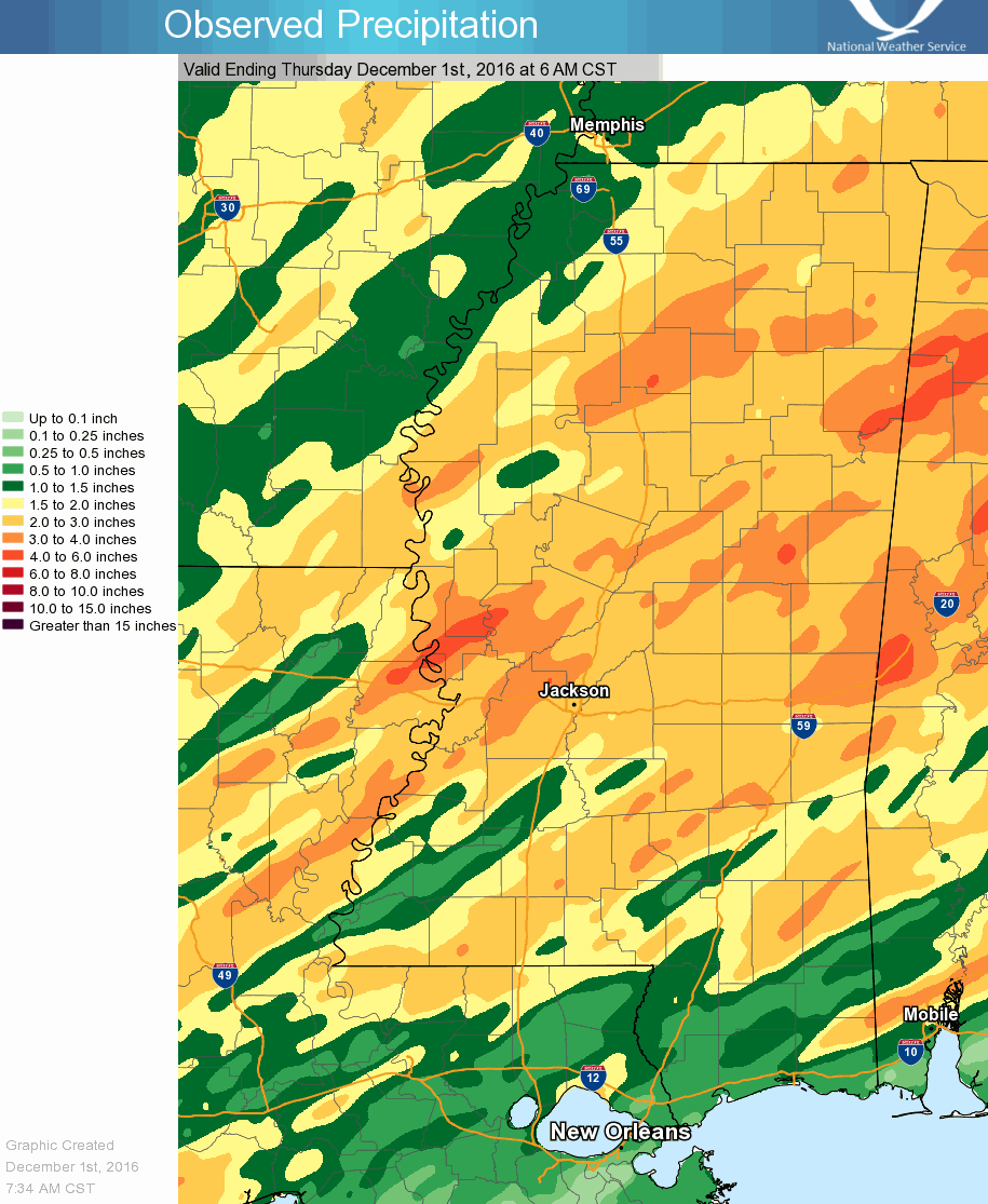
Precipitation Summary

3 day total - 11/28/16 6 AM to 12/01/16 6 AM

Back to the top


Local Storm Reports
Click on the map for additional details.

Local Storm Reports
Storm Reports Key

Back to the top