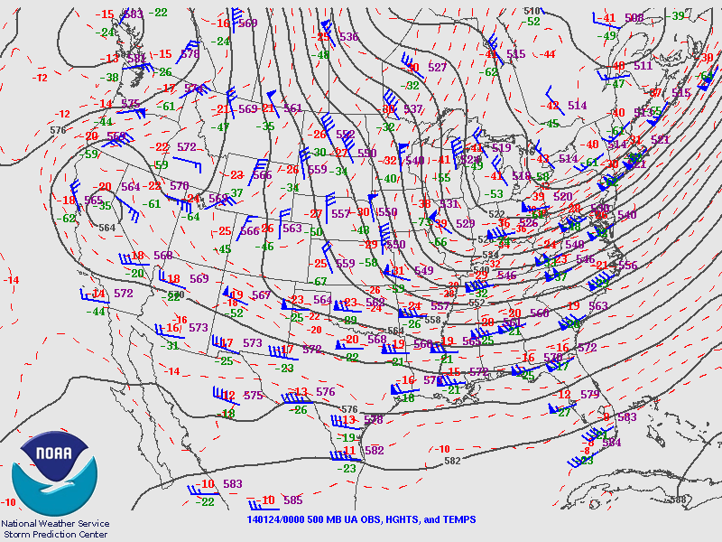
A cold airmass moved down through the north central Plains to the Mid Mississippi Valley into the ArklaMiss region. A deep upper trough and cold temperatures aloft persisted to the east of the Mississippi River for the past few weeks with another shot of arctic air that began to move into the region the afternoon of January 23rd. A weak upper disturbance increased moisture across the area, and enough moisture and cold air was available for snow to begin falling on the afternoon of January 23rd. Low level dry air kept snowfall light in the Interstate 20 corridor but moisture was sufficient for decent snowfall in southwestern Mississippi and northeast Louisiana. Low level dry air began to move in late in the evening on January 23rd, limiting snowfall in the I-20 corridor. The highest snowfall totals of 1-3 inches occurred in Adams County, Mississippi to northern Concordia to southern Catahoula parishes in Louisiana. There were reports of light snow that occurred from Vicksburg to Jackson to Hattiesburg. Snow persisted into the early afternoon hours of January 24th before the moisture moved out the area on the afternoon of January 24th.

Highest reported snow accumulation totals from the evening of January 23rd through January 24th. Click to enlarge.
| State | Location | Source | Amount |
|---|---|---|---|
| LA | Jonesville | LSR | 2.5 |
| LA | Larto Lake | LSR | 2.5 |
| LA | Red River Lock (Catahoula) | COOP | 2.0 |
| LA | Harrisonburg | LSR | 2.0 |
| MS | Natchez | COOP | 1.5 |
| LA | Ferriday | LSR | 1.5 |
| LA | Vidalia | LSR | 1.5 |
| LA | Jonesville Locks | COOP | 1.0 |
| MS | Meadville | COOP | 1.0 |
| MS | Kingston | LSR | 1.0 |
| MS | Natchez | LSR | 1.0 |
| MS | Meadville | LSR | 0.8 |
| MS | Roxie | LSR | 0.8 |
| LA | Clayton | LSR | 0.8 |
| MS | Meadville 5 SSE | COOP | 0.8 |
| LA | Enterprise | LSR | 0.8 |
| MS | Union Church | LSR | 0.5 |
| MS | Brookhaven 2 SW | LSR | 0.5 |
| MS | Fayette | LSR | 0.3 |
| MS | McNair | LSR | 0.3 |
| MS | Allen | LSR | 0.3 |
| MS | Pattison | LSR | 0.3 |
| LA | Winnsboro | LSR | 0.3 |
| MS | Brookhaven 1 W | LSR | 0.3 |
| MS | Brookhaven | COOP | 0.3 |
| MS | Caseyville | LSR | 0.3 |
| MS | Wesson 1 S | LSR | 0.3 |
| MS | Brookhaven City | COOP | 0.1 |
| MS | Hazlehurst | LSR | 0.1 |
| LA | St. Joseph | LSR | 0.1 |
| MS | Port Gibson | COOP | 0.1 |
| MS | Brookhaven 1 S | LSR | 0.1 |
| AR | Portland | COOP | T |
| LA | Lake Providence | COOP | T |
| MS | Jackson Airport | NWS | T |