Jackson, Mississippi
Weather Forecast Office
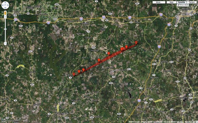
Damage Survey from Jasper & Newton Counties
 |
Location: Jasper & Newton Counties
Time of Event: 231 am 03/26/09
Beginning Point: 0.9 ESE Montrose 32.1167 -89.21727
Ending Point: 5S Chunky 32.2445 -88.9223
Rating: EF1, max winds 110 MPH
Path Length: 17 miles
Maximum Width: 500 yards
Fatalities: 0
Injuries: 1
Summary of Damages: This tornado started just off of CR 20, on private property, about 1 mile ESE of Montrose. Several trees were uprooted/snapped at this location and again just to the E along CR 206. The tornado moved across several miles of wooded bottom land before crossing CR 2414. Substantial damage occurred along CR 2414, 4 homes heavily damaged, worst was where a home on pillars was pushed off the blocks. One quarter of the roof was heavily damaged. Numerous trees were snapped and uprooted with 2 large trees down through a mobile home. An atv was rolled down a hill over 100 yds.
The tornado then crossed Hwy 503 and destroyed and old church building. The weakly fastened roof was blown off and then the walls collapse inward. Numerous trees and several power lines snapped. Path width was around 500 yds at this point. The tornado continued to the ENE through northern Jasper Co. Another home was pushed off the pillars and peeled all the tin off the roof, on CR 24. The tornado then crossed CR 2422 and downed many more trees, tore part of the roof off one home and damaged an old shed and old home where some of the tin roof as peeled off. The tornado crossed into Newton Co at 252 am. It then crossed Griffis Fountain Rd. The tornado crossed Parks Mill Rd and dissipated just to the east of that point. Many trees were damaged along Parks Mill Rd.
US Dept of Commerce
National Oceanic and Atmospheric Administration
National Weather Service
Jackson, Mississippi
234 Weather Service Dr.
Flowood, MS 39232
601-936-2189
Comments? Questions? Please Contact Us.

