Jackson, Mississippi
Weather Forecast Office
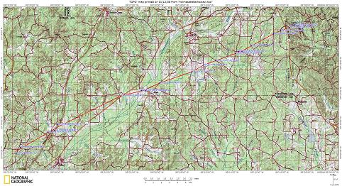
Beginning Point: 3.5 mi W of Ethel at 1228 PM CST
Ending Point: 2.5 mi SSE of Ackerman at 1258 PM CST
Rating: EF-3 with maximum winds of 145 MPH
Path Length: 24 miles
Maximum Width: 0.5 miles
Casualties: 3 Injuries
Summary of Damage: The tornado started with a path of tree damage which intensified shortly after the beginning point. In some areas nearly every tree was snapped off or uprooted. The tornado reached its widest point as it crossed the Natchez Trace Parkway, where dozens of trees were snapped and uprooted. The tornado caused significant structural damage to several buildings just to the southwest of McCool. One cinder block constructed building sustained nearly total destruction from a combination of a very large hardwood tree falling on it, along with other wind damage. A room addition to the back of a frame home was removed. After the tornado passed McCool, it narrowed and weakened somewhat, with tree damage continuing to occur. The tornado then intensified again as it passed south of the town of Weir. Here a dairy complex was heavily damaged. A well-constructed milking parlor was totally destroyed with all exterior walls collapsed or destroyed. A large 9000 pound trailer was picked up and flipped onto the top of a farm building. Several large wood and metal livestock buildings were totally destroyed. A grain silo was also destroyed. After the tornado passed this point, it did not encounter any additional structures, but a path of tree damage continued for several miles before the tornado dissipated near Choctaw Lake.
 |
US Dept of Commerce
National Oceanic and Atmospheric Administration
National Weather Service
Jackson, Mississippi
234 Weather Service Dr.
Flowood, MS 39232
601-936-2189
Comments? Questions? Please Contact Us.

