The Fire Weather program is used by land management personnel primarily for input in decision-making related to pre-suppression and other planning, that may impact firefighter safety, protection of the public and property, and resource allocation. The primary source of information is the routinely issued Fire Weather Planning Forecast. In Hawaii, this product is issued once a day around 5:30 am HST.
The Spot Forecasts are issued by WFO HFO at the request of and in support of wildfire suppression and natural resource management. These forecasts aid the land management and fire control agencies in protecting life and property during wildland fires, hazardous fuels reduction, and the rehabilitation and restoration of natural resources. Spot Forecasts can be issued for the first 36 hours.
Need an outlook on weather conditions beyond the 36 hours included in the Spot Forecast? Use the NWS' Point and Click forecast to get information for up to 7 days ahead.
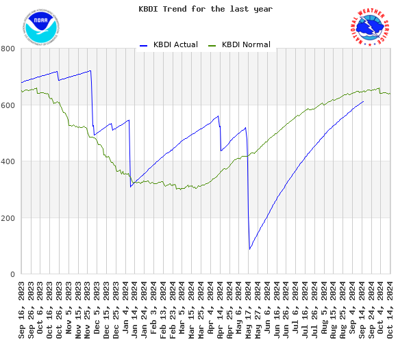
The Keetch-Byram Drought Index (KBDI), which is used to track fuel conditions and assess wildfire potential, describes soil moisture deficit with values ranging from 0 to 800. A value of 800 indicates extreme drought, and a value of 0 reflects saturated soil. KBDI at the Honolulu International Airport (PHNL) fluctuates through the year, while values in excess of 600 represent the highest 34% of values from 1975-2010. A KBDI of greater than 600 is typically encountered by late July and normally persists through late October.

