This web page is provided by the National Weather Service - Honolulu Forecast Office as an educational resource for teachers, students and anyone interested in tropical island weather. The links above will guide you to information that can be utilized by all ages.
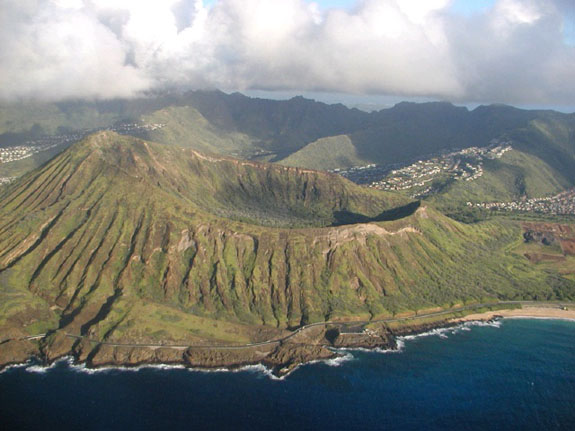
If you plan to visit the Hawaiian islands and/or are interested in climatology information for specific months, please visit:
http://www.nws.noaa.gov/climate/index.php?wfo=hnl
http://www.cdc.noaa.gov/USclimate/
If you would like additional information, or want to inquire about a tour or talk, please contact our Webmaster at W-HFO.Webmaster@noaa.gov

Supplies:
Directions
This activity requires adult supervision due to the use of hot water, glass, and the aerosol or matches.
First, make sure the glass jar is clean. Fill the bottom of the glass jar with hot water (approx. 1" deep). You may want to swirl the hot water on the sides of the jar to warm up the glass, otherwise, condensation will immediately occur. Take the lid of the glass jar and turn it upside down so that it acts as a small bowl. Put ice in the lid and place the lid on top of the jar. Notice that while you may have some condensation on the glass, there is no cloud floating inside the jar. Next, take a can of air refreshener or hair spray, lift the lid of ice, spritz a small amount of aerosol into the jar and quickly place the lid of ice on top of the jar. (Instead of an aerosol, an adult can light a match, blow it out, then throw the smoking match inside the jar and replace the lid of ice.) Now hold up the dark colored paper to the glass and look for wisps of cloud to start swirling inside. You may also want to shine a flashlight inside the jar to see the cloud better. Lift the lid and let the cloud out so that you can touch it.
 Click on Calvin to see photos of this activity.
Discussion:
Congratulations, you just made a cloud! But how did it work and how can this activity help us understand weather in Hawaii?
Just like a baker uses a recipe to bake a cake, the atmosphere must have three ingredients to make a cloud: 1) moisture, 2) lifting/cooling, 3) Cloud Condensation Nuclei (CCN). The moisture was provided by the hot water in the bottom of the jar. Some of that hot water evaporated into water vapor so that the air inside the jar would be moist and warm. As the warm, moist air rises in the jar, it gets cooled by the ice on top. When water vapor cools, it wants to turn back into liquid, but it needs to condense onto a surface. The aerosol (or smoke from the match) provides a surface for the water vapor to condense into tiny cloud droplets. It's called Cloud Condensation Nuclei because it's a very small particle that can float in the air to help water vapor condense into clouds. The cloud swirls inside the jar due to the circulation of warm air rising and cold air sinking.
The islands of Hawaii act just like the jar. Some of the water in the ocean evaporates into the air providing moisture. When the islands heat up during the day, it heats that moist air so that it will rise. (This process is called convection.) The higher up you go in the sky, the colder the air gets. Think about climbing up Mauna Kea, it's much colder up on top of the volcano then down at the beach. The ice in the experiment represents the atmosphere cooling as the air rises. When that water vapor is cold enough to condense it has many choices of CCN. The aerosol (or smoke) represents small particles floating in the air. In Hawaii, the most common CCN are sea salt aerosols, but CCN can also be dust, smoke, air pollution or volcanic vog.
Have you seen the clouds that often form on the windward coasts of the islands? The same concept can be applied, except the air doesn't rise from the land heating up during the day. Instead, the air rises with the wind. The Tradewinds carry moist air from over the ocean. When the Tradewinds run into the mountains, it carries that moist air up the mountain where the air is colder and the water vapor condenses onto CCN and becomes a cloud.
Supplies
Directions
Take 3 styrofoam cups and place them upside down in a triangular shape. Place the pie pan on top. Fill pie pan 3/4 full with water at room temperature. Take another cup, fill it with hot water then carefully slide it under the center of the pie pan. Try not to touch the pie pan so that the water inside remains still. Put a few drops of food coloring inside the eyedropper. Next, let the eyedropper touch the bottom of the pie pan right above the hot water. Squeeze out 1 or 2 drops of color, then carefully remove the eyedropper. Watch the movement of the food color inside the pan. Look at it from above and also from the sides. Draw what you see.
Try this experiment again, except place a cup of hot water near the side of the pan and a cup of ice under the center of the pan. Sqeeze 1-2 drops of color above the hot water. How does the food color move this time?
 Click on Wendy to see photos of this activity.
Discussion:
Congratulations! You just created a convection cell! Convection is the movement of mass within a fluid. That fluid could be water (like the ocean), but air is also considered a fluid. In meteorology, convection means the upward movement of air. A convection cell is the circulation of air that includes both upward and downward motion. Did you notice how the drops of color move in the pie pan? Look from the side of the pan. You should see the color rising if it's near the cup with hot water and sink when it's near the cup with ice.
This activity is a great example of sea breezes in Hawaii during the day. If the trade winds are very light or not even blowing, then the islands will develop sea or land breezes (depending on day or night).
If the sun is out, it heats up the land so that it is much warmer than the ocean. This causes the air above the land to heat up while the air over the ocean is cooler. Hot air will rise and cool air will sink. Together, this rising and sinking motion creates a convection cell just like in the activity. The cup of hot water represents the land heated by the sun. The ocean is cooler than the land and is represented by the cup of ice. The water inside the pie pan represents the air above the ocean and land. The food coloring allowed us to see the movement of the water.
Look at the diagram below:
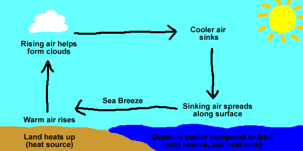
As the warm air rises over land, it must be replaced by the cooler air over the ocean. We call this a sea breeze because it's a breeze that comes from the sea. Meteorologists always name winds based on where they come from. (If you were born and raised in Hawaii, then went to visit the Mainland, you would tell people that you were from Hawaii.)
At night time, the convection cell is reversed and we call it a land breeze because the wind near the surface now blows from the land out to sea. This happens because the land cools down at night and will get colder than the ocean. The air above the ocean is now warmer compared to the cooler air over the land at night. (Have you ever noticed how the ocean feels warmer in the evening? It's not because the ocean heats up at night, it's because the air at night got colder.) This is seen in the diagram below:

It is important to understand that the ocean's temperature doesn't change much in a given location. It's quick and easy to heat up a cup of water...but it would take a very long time to heat up the entire ocean! When we talk about land and sea breezes, these winds occur due to the land being colder or warmer than the ocean. That causes the air above land to be a different temperature than the air above the ocean. Also, keep in mind that land and sea breezes have a difficult time developing if the trade winds are blowing strong because this disrupts the convection cell.
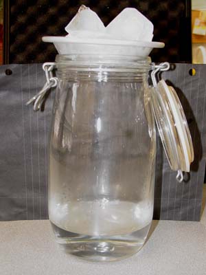
Photo 1: Before Aerosol (match)
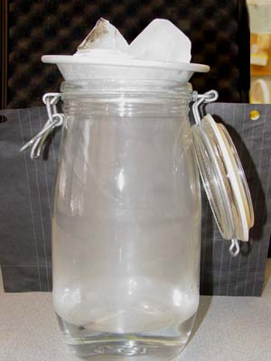
Photo 2: After Aerosol (match)
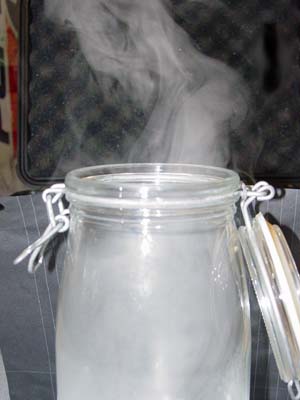
Photo 3: Lid removed to release cloud
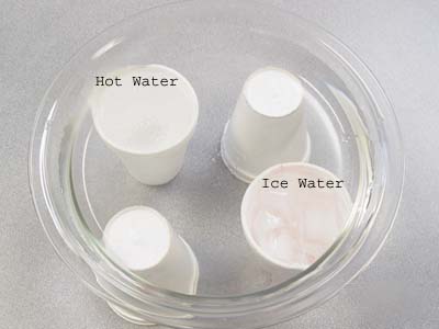
Photo 1: Setup
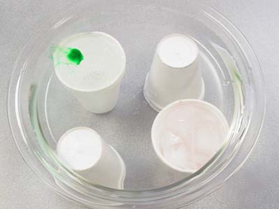
Photo 2: Drop of food color over hot water
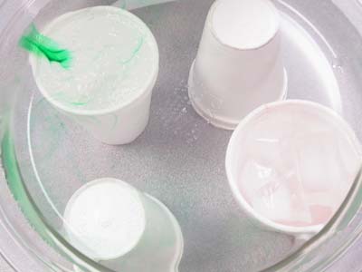
Photo 3: Food color begins to rise and move towards cold water
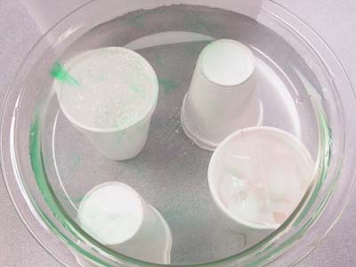
Photo 4: Food color continues to spread away from heat source
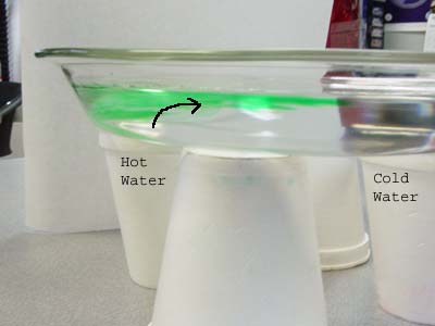
Photo 5: Food Color rises over hot water
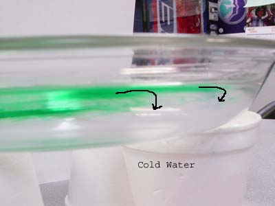
Photo 6: Food Color begins to sink over cold water
If you ever wonder about the weather...then come play with the WEATHER WONDERS!
 Sonny Shine |
 Dew Drop |
 Wendy Wind |
 Calvin Cloud |
 Severe Sam |
 Belinda Balloon |
 Patsy Pressure Patsy Pressure |
 Tommy Temperature |
|
|
High pressure, Low pressure, fronts, shearlines, windward & mauka showers...what does it all mean? Here's a basic guide to help you understand the weather forecasts on television:
High Pressure: That big "H" on the weather map marks the center of a High Pressure cell. When air from above sinks down towards the earth, it creates high pressure. High Pressure gives us good weather. Clouds can't grow and build into big storms because the sinking air pushes down on the clouds.
Low Pressure: The big "L" on the weather map is the center of a Low Pressure cell. Low pressure means air is rising and usually indicates bad weather. When air rises, it is considered unstable. Low pressure usually brings more clouds and rain. Clouds can grow bigger and taller when air rises. All storms (thunderstorms, cold fronts, Kona Lows, Hurricanes, Tornadoes, etc) are a result of very low pressure.