
Surf Forecast Issued: 07/17/2026 11:32:00 AM UTC
728
FZHW52 PHFO 170132
SRFHFO

Surf Zone Forecast for Hawaii
National Weather Service Honolulu HI
332 PM HST Thu Jul 16 2026

.DISCUSSION...
A small, long-period WNW swell holds steady tonight along north and
west shores before fading Friday and dropping north shores to
flat/tiny by the weekend.

Meanwhile, south-facing shores remain slightly below average as old
SW and WNW swells fade, but a fresh SSW swell arriving late Friday
will briefly boost surf back to near average. A larger, moderate south
swell is expected to build Sunday through early next week, bringing
potentially above-average (though sub-advisory) waves to south
shores.

On east-facing shores, strengthening trade winds will make surf
slightly bigger and choppy this weekend, with a potential small-to-
moderate swell arriving early-to-mid next week from Tropical Storm
Elida.

HIZ003-029>031-180245-
Kauai-
332 PM HST Thu Jul 16 2026

__________________________________________________________________
                      Tonight                    Friday

Shores                  Surf                       Surf
                     PM     AM                  AM     PM
__________________________________________________________________

North Facing         2-4    1-3                 1-3    1-3
West Facing          3-5    2-4                 2-4    2-4
South Facing         2-4    2-4                 2-4    3-5
East Facing          2-4    2-4                 2-4    2-4


.TONIGHT...
Weather.....................Partly cloudy until 12 AM, then mostly
                            cloudy. Scattered showers.
Low Temperature.............In the mid 70s.
Winds.......................East winds around 10 mph.
Tides...
   Hanalei Bay..............High 2.4 feet 04:43 PM HST.
                            Low 0.3 feet 11:16 PM HST.
                            High 1.0 feet 04:56 AM HST.
   Nawiliwili...............High 2.3 feet 05:44 PM HST.
                            Low 0.3 feet 12:38 AM HST.
                            High 1.0 feet 05:57 AM HST.

.FRIDAY...
Weather.....................Mostly sunny. Isolated showers.
High Temperature............In the upper 80s.
Winds.......................East winds around 10 mph.
Tides...
   Hanalei Bay..............Low 0.2 feet 09:45 AM HST.
                            High 2.2 feet 05:17 PM HST.
   Nawiliwili...............Low 0.2 feet 11:07 AM HST.
Sunrise.....................6:04 AM HST.
Sunset......................7:23 PM HST.

$$

HIZ006-007-009-032>035-180245-
Oahu-
332 PM HST Thu Jul 16 2026

__________________________________________________________________
                      Tonight                    Friday

Shores                  Surf                       Surf
                     PM     AM                  AM     PM
__________________________________________________________________

North Facing         2-4    1-3                 1-3    1-3
West Facing          2-4    2-4                 2-4    2-4
South Facing         2-4    2-4                 2-4    3-5
East Facing          2-4    2-4                 2-4    2-4


.TONIGHT...
Weather.....................Partly cloudy. Isolated showers.
Low Temperature.............In the mid 70s.
Winds.......................East winds 10 to 15 mph.
Tides...
   Honolulu.................High 2.3 feet 05:58 PM HST.
                            Low 0.1 feet 01:03 AM HST.
   Waianae..................High 2.2 feet 06:18 PM HST.
                            Low 0.1 feet 01:21 AM HST.
   Haleiwa..................High 1.9 feet 04:56 PM HST.
                            Low 0.1 feet 10:58 PM HST.
                            High 0.8 feet 05:36 AM HST.
   Mokuoloe.................High 2.6 feet 04:53 PM HST.
                            Low 0.7 feet 11:37 PM HST.
                            High 1.2 feet 04:13 AM HST.

.FRIDAY...
UV Index....................Extreme.
Weather.....................Mostly sunny. Scattered showers.
High Temperature............In the mid 80s.
Winds.......................East winds around 15 mph.
Tides...
   Honolulu.................High 1.0 feet 06:38 AM HST.
                            Low 0.3 feet 11:44 AM HST.
   Waianae..................High 1.0 feet 06:58 AM HST.
                            Low 0.3 feet 12:02 PM HST.
   Haleiwa..................Low 0.2 feet 09:39 AM HST.
                            High 1.7 feet 05:34 PM HST.
   Mokuoloe.................Low 0.1 feet 10:11 AM HST.
                            High 2.4 feet 05:22 PM HST.
Sunrise.....................6:00 AM HST.
Sunset......................7:17 PM HST.

$$

HIZ017-018-045>050-180245-
Maui-
332 PM HST Thu Jul 16 2026

__________________________________________________________________
                      Tonight                    Friday

Shores                  Surf                       Surf
                     PM     AM                  AM     PM
__________________________________________________________________

North Facing         1-3    0-2                 0-2    0-2
West Facing          1-3    1-3                 1-3    1-3
South Facing         2-4    2-4                 2-4    3-5
East Facing          2-4    2-4                 2-4    2-4


.TONIGHT...
Weather.....................Partly cloudy. Scattered showers.
Low Temperature.............In the mid 70s.
Winds.......................East winds 10 to 15 mph.
Tides...
   Kahului..................High 2.8 feet 04:36 PM HST.
                            Low 0.6 feet 11:19 PM HST.
                            High 1.4 feet 04:08 AM HST.

.FRIDAY...
Weather.....................Mostly sunny. Scattered showers.
High Temperature............In the mid 80s.
Winds.......................East winds 10 to 15 mph.
Tides...
   Kahului..................Low 0.0 feet 10:03 AM HST.
                            High 2.6 feet 05:06 PM HST.
Sunrise.....................5:54 AM HST.
Sunset......................7:10 PM HST.

$$

HIZ052>054-180245-
Big Island Windward and Southeast-
332 PM HST Thu Jul 16 2026

__________________________________________________________________
                      Tonight                    Friday

Shores                  Surf                       Surf
                     PM     AM                  AM     PM
__________________________________________________________________

North Facing         0-2    0-2                 0-2    0-2
East Facing          2-4    2-4                 2-4    2-4
South Facing         2-4    2-4                 2-4    3-5


.TONIGHT...
Weather.....................Mostly cloudy. Numerous showers.
Low Temperature.............In the lower 70s.
Winds.......................East winds 5 to 10 mph.
Tides...
   Hilo Bay.................High 3.0 feet 05:12 PM HST.
                            Low 0.4 feet 11:55 PM HST.
                            High 1.6 feet 05:11 AM HST.

.FRIDAY...
Weather.....................Partly sunny. Scattered showers.
High Temperature............In the mid 80s.
Winds.......................Southeast winds around 5 mph, becoming
                            northeast in the afternoon.
Tides...
   Hilo Bay.................Low 0.1 feet 10:57 AM HST.
                            High 2.7 feet 05:46 PM HST.
Sunrise.....................5:51 AM HST.
Sunset......................7:02 PM HST.

$$

HIZ023-026-051-180245-
Big Island Leeward-
332 PM HST Thu Jul 16 2026

__________________________________________________________________
                      Tonight                    Friday

Shores                  Surf                       Surf
                     PM     AM                  AM     PM
__________________________________________________________________

West Facing          3-5    2-4                 2-4    2-4
South Facing         2-4    2-4                 2-4    3-5


.TONIGHT...
Weather.....................Mostly cloudy until 12 AM, then mostly
                            clear. Hazy. Scattered showers.
Low Temperature.............In the upper 60s.
Winds.......................West winds around 5 mph early in the
                            afternoon, becoming light and variable.
Tides...
   Kona.....................High 2.4 feet 05:50 PM HST.
                            Low 0.2 feet 12:32 AM HST.
                            High 1.2 feet 05:49 AM HST.
   Kawaihae.................High 2.7 feet 05:55 PM HST.
                            Low 0.0 feet 01:00 AM HST.

.FRIDAY...
Weather.....................Sunny. Hazy. Isolated showers.
High Temperature............In the upper 80s.
Winds.......................Southwest winds around 5 mph.
Tides...
   Kona.....................Low 0.0 feet 11:34 AM HST.
   Kawaihae.................High 1.2 feet 06:33 AM HST.
                            Low 0.2 feet 11:47 AM HST.
Sunrise.....................5:55 AM HST.
Sunset......................7:06 PM HST.

$$


__________________________________________________________________

Product Legend:

Surf:        Height of the surf from trough to crest (face value)
             in feet.

Tides:       Heights displayed are relative to the Mean Lower Low
             Water (MLLW) datum in feet.

Surf heights can vary significantly from beach to beach along a
coastline. Surf larger than the upper end of the range provided in
the forecast will occur periodically, sometimes up to a few hours
apart. Expect to encounter rip currents in or near the surf zone,
with rip current strength increasing with surf size. Swimmers are
urged to exercise caution at all times and enter the water near a
lifeguard.

For the latest beach hazard and safety information at individual
beaches in Hawaii refer to:

https://hawaiibeachsafety.com

__________________________________________________________________

$$
Additional Resources:
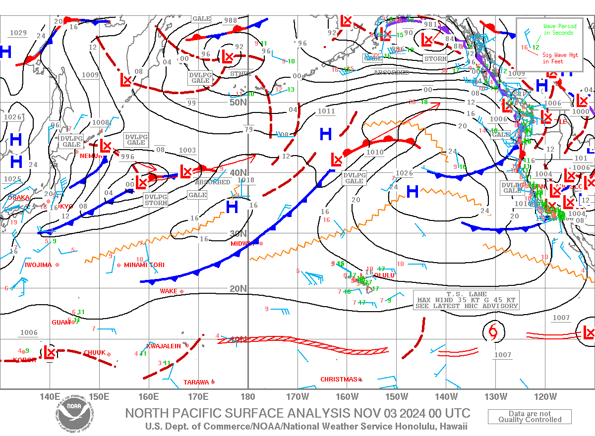
Latest North Pacific Surface Analysis

