|
February 22-23, 2023 Extended Winter Storm Brings Widespread Heavy Snow Across The Area
Event Overview A complex late February winter storm caused significant impacts across all of Wisconsin over a two day period. Widespread snowfall of 8-14 inches was common place, with several locations reporting well over a foot of snow. The highest snowfall storm total accumulation was in Door County in Sturgeon Bay where 15 inches was reported. Some lake enhancement likely contributed to the final totals there. Strong winds were also observed especially on Wednesday night, when gusts as high as 52 mph were reported, creating localized blizzard conditions. Across southern Wisconsin, sleet and dangerous freezing rain was also observed. These impacts caused many schools and business to close as road conditions were extremely hazardous. This storm was somewhat unusual in that it was not associated with the classic intense and rapidly deepening cyclone that moves from the Colorado Rockies northeast to southern Lake Michigan, dumping copious amounts of continuously falling snow over a 12 hour period or so. Instead the snowfall came in 3 primary episodes over an approximate 2-3 day period, separated by brief lulls in snowfall intensity. This aspect of the winter storm made messaging of the impacts somewhat challenging. For more details of the winter storm, please refer to the tabs below.
Also, you can visit our neighboring offices Top New Articles about this winter storm: La Crosse & Milwaukee
Please see tabs below for more information. Click on any image/animation for a larger view. |
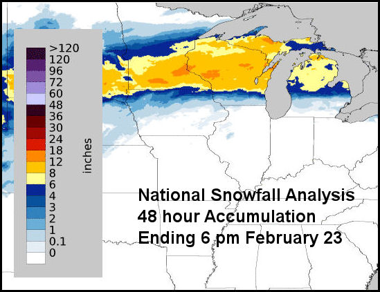
There was a broad swath of 8 to 14 inches across nearly the entire NWS Green Bay forecast area with a several reports in excess of a foot (darkest orange highlights in the image above). The swath of heavy snow extend from the western Dakotas east across Wisconsin to lower Michigan. |
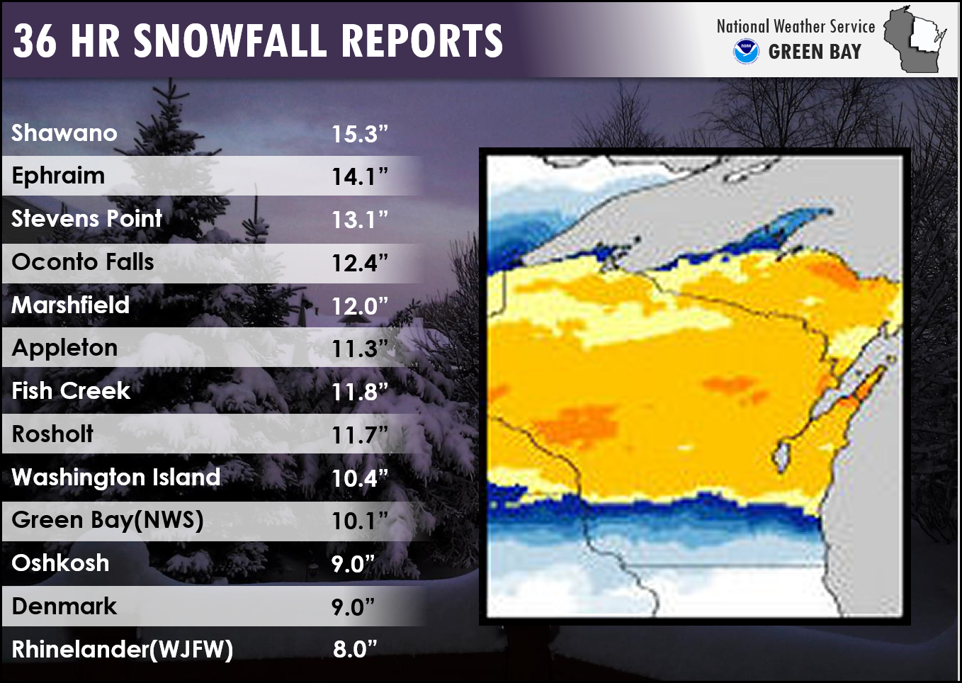
Snowfall Reports
...60 HOUR SNOWFALL TOTALS ENDING AROUND 6 AM(2/24)...

LOCATION                     AMOUNT    TIME/DATE       PROVIDER

...WISCONSIN...

...BROWN COUNTY...
NWS GREEN BAY                12.7 IN   0600 AM 02/24   COOP
GREEN BAY 3.8 SSE            11.9 IN   0700 AM 02/24   COCORAHS
SUAMICO 4.4 WNW              10.6 IN   0700 AM 02/24   COCORAHS
DENMARK WWTP                 10.0 IN   0800 AM 02/24   COOP
WRIGHTSTOWN 0.4 ENE           9.2 IN   0700 AM 02/24   COCORAHS

...CALUMET COUNTY...
BRILLION                     11.0 IN   0715 AM 02/24   COOP
CHILTON 0.5 E                 9.5 IN   0700 AM 02/24   COOP

...DOOR COUNTY...
EPHRAIM 1 NE - WWTP          17.7 IN   0855 AM 02/24   COOP
STURGEON BAY                 16.5 IN   0700 AM 02/24   COOP
SISTER BAY 1 N               14.0 IN   0700 AM 02/24   COCORAHS
WASHINGTON ISLAND            13.9 IN   0700 AM 02/24   COOP
FISH CREEK 1 E WWTP          12.5 IN   0700 AM 02/24   UCOOP
ELLISON BAY 1 ENE             9.2 IN   0700 AM 02/24   COCORAHS
FORESTVILLE 4 E               6.2 IN   0700 AM 02/24   UCOOP

...FLORENCE COUNTY...
SPREAD EAGLE 1 NW            11.0 IN   0700 AM 02/24   COCORAHS

...FOREST COUNTY...
ARGONNE 1.5 NW                9.5 IN   0723 AM 02/24   COOP

...KEWAUNEE COUNTY...
CASCO 0.4 NNW                 6.5 IN   0700 AM 02/24   COCORAHS
KEWAUNEE                      6.0 IM   0700 AM 02/24   COOP

...LANGLADE COUNTY...
SUMMIT LAKE                  13.4 IN   0500 AM 02/24   COOP
WHITE LAKE 1.4 SE            12.0 IN   0800 AM 02/24   COOP
ANTIGO 1 SSW                 10.6 IN   0800 AM 02/24   COOP

...LINCOLN COUNTY...
MERRILL 8 W                  13.7 IN   0600 AM 02/24   UCOOP
TOMAHAWK 4.6 N               13.0 IN   0700 AM 02/24   COCORAHS
TOMAHAWK 1.2 SSW             11.7 IN   0700 AM 02/24   COCORAHS
BRADLEY 1.0 NE                9.5 IN   0700 AM 02/24   COOP

...MANITOWOC COUNTY...
TWO RIVERS                   12.6 IN   0700 AM 02/24   COOP
SHOTO 1 NW                   12.0 IN   0700 AM 02/24   COCORAHS
TWO RIVERS 2 NW              11.0 IN   0533 AM 02/24   COCORAHS
MISHICOT 0.1 NNW             10.0 IN   0800 AM 02/24   COCORAHS

...MARATHON COUNTY...
WAUSAU 1 ENE                 14.0 IN   0700 AM 02/24   COCORAHS
MOON 1 E                     13.8 IN   0500 AM 02/24   COOP
SPENCER - WWTP               12.7 IN   0730 AM 02/24   UCOOP
WAUSAU(WSAW TV-7)            12.0 IN   1000 PM 02/23   MEDIA
WAUSAU 2.4 W                 12.5 IN   0800 AM 02/24   COCORAHS
EVERGREEN 1.5 WSW            10.6 IN   0700 AM 02/24   COCORAHS

...MARINETTE COUNTY...
MENOMINEE 1.6 S              16.0 IN   0730 AM 02/24   COOP
ATHELSTANE 1.6 E             11.2 IN   0600 AM 02/24   UCOOP
ATHELSTANE 6 SW              11.1 IN   0700 AM 02/24   COOP
PESHTIGO 1 S                 11.0 IN   0730 AM 02/24   COOP
WAUSAUKEE 1.6 NW             10.9 IN   0800 AM 02/24   COOP
AMBERG 9 E                    8.3 IN   0640 AM 02/24   UCOOP
MARINETTE - WPS               8.2 IN   0605 AM 02/24   UCOOP

...OCONTO COUNTY...
OCONTO FALLS 1.0 SE          15.5 IN   0630 AM 02/24   COCORAHS
PULASKI - WWTP               12.5 IN   0600 AM 02/24   COOP
MOUNTAIN 0.9 E               12.4 IN   0700 AM 02/24   COCORAHS
SURING                       12.4 IN   0700 AM 02/24   COOP

...ONEIDA COUNTY...
RHINELANDER 2 SW             11.8 IN   0730 AM 02/24   COOP
HAZELHURST 2.1 SSE           11.7 IN   0700 AM 02/24   COCORAHS
RHINELANDER(WJFW)            11.6 IN   1000 PM 02/23   MEDIA
RHINELANDER 4 NE             11.4 IN   0600 AM 02/24   COOP
RHINELANDER 5.5 NW           10.1 IN   0600 AM 02/24   COCORAHS
MINOCQUA                      8.8 IN   0630 AM 02/24   COOP

...OUTAGAMIE COUNTY...
SHIOCTON 0.6 NW              14.3 IN   0730 AM 02/24   COOP
APPLETON                     13.3 IN   0500 AM 02/24   COOP
NEW LONDON 2 SE              11.8 IN   0630 AM 02/24   COOP
APPLETON WHBY RADIO          11.5 IN   1000 AM 02/24   UCOOP
NEW LONDON 4.1 N             10.1 IN   0600 AM 02/24   COCORAHS

...PORTAGE COUNTY...
STEVENS POINT                14.6 IN   0730 AM 02/24   COOP
ROSHOLT                      13.2 IN   0730 AM 02/24   COOP
AMHERST 3 SE                 11.6 IN   0700 AM 02/24   UCOOP
AMHERST 2.6 SSE              11.6 IN   0700 AM 02/24   COCORAHS
RUDOLPH 1 NNE                10.4 IN   0500 AM 02/24   COCORAHS
PLOVER 1.8 W                 10.3 IN   0700 AM 02/24   COCORAHS

...SHAWANO COUNTY...
SHAWANO 2 SSW                18.2 IN   0800 AM 02/24   COOP
PELLA 3 SE                   14.9 IN   0530 AM 02/24   UCOOP
CECIL 5.6 ENE                14.2 IN   0700 AM 02/24   COCORAHS
STOCKBRIDGE-MUNSEE RESERVATI 13.2 IN   0730 AM 02/24   COOP
SPLIT ROCK 1 NNW             12.2 IN   0800 AM 02/24   COCORAHS

...VILAS COUNTY...
ST GERMAIN 0.6 NW            11.0 IN   0700 AM 02/24   COOP
BOULDER JUNCTION 9 ENE       9.5 IN    0700 AM 02/24   COCORAHS
PRESQUE ISLE                 8.9 IN    0600 AM 02/24   COOP
PHELPS 4.2 N                 8.0 IN    0755 AM 02/24   COOP
BOULDER JUNCTION 1.4 NE      7.6 IN    0700 AM 02/24   COCORAHS

...WAUPACA COUNTY...
WAUPACA 1 E                  11.9 IN   0600 AM 02/24   COOP
NEW LONDON - WWTP             9.0 IN   0700 AM 02/24   UCOOP

...WAUSHARA COUNTY...
WAUTOMA 3 SE                 11.8 IN   0630 AM 02/24   COOP
WILD ROSE 0.5 E              10.1 IN   0600 AM 02/24   COCORAHS

...WINNEBAGO COUNTY...
OMRO 1 WSW                   11.6 IN   0700 AM 02/24   COCORAHS
OSHKOSH                       9.7 IN   0700 AM 02/24   COOP
NEENAH 1.1 ENE                9.0 IN   0700 AM 02/24   COCORAHS
OSHKOSH SOUTHEAST             6.7 IN   0700 AM 02/24   UCOOP
OSHKOSH 1.6 ESE               6.7 IN   0700 AM 02/24   COCORAHS

...WOOD COUNTY...
MARSHFIELD 5.6 SSW           13.3 IN   0700 AM 02/24   COCORAHS
MARSHFIELD 0.8 N             11.3 IN   0730 AM 02/24   COOP
PITTSVILLE - WWTP            11.5 IN   0700 AM 02/24  UCOOP
PORT EDWARDS 2 E              9.0 IN   0645 AM 02/24  COCORAHS


OBSERVATIONS ARE COLLECTED FROM A VARIETY OF SOURCES WITH VARYING
EQUIPMENT AND EXPOSURES. WE THANK ALL VOLUNTEER WEATHER OBSERVERS
FOR THEIR DEDICATION. NOT ALL DATA LISTED ARE CONSIDERED OFFICIAL.
Wind Gusts
.png)
The peak wind gust of 52 mph at Green Bay, should not be too surprising as the northeast winds were blowing unimpeded directly down the the bay of Green Bay. The strongest winds were observed primarily during the overnight hours of Wednesday February 22 into the early morning of Thursday February 23.
|
|
Environmental Overview
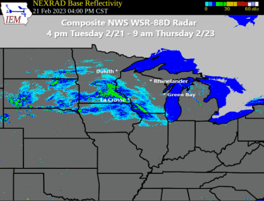
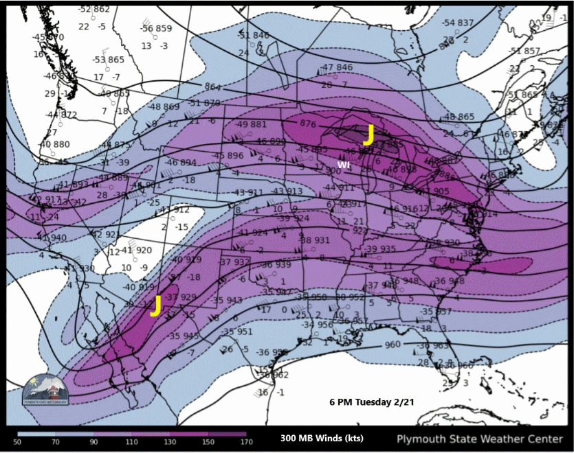
This was a rather complex winter storm as there were several factors at play that led to the long duration heavy snowfall event. As can be seen in the regional radar animation (Figure 1), there was an elongated area of persistent, moderate to heavy precipitation that stretched across much of the northern CONUS. The primary features that led to this extensive precipitation area included a very strong W-E orientated temperature gradient with very cold air near the US-Canadian border and unseasonable warm air across much of the central and southern Mississippi Valley (Figure 7). These air masses were separated by a surface frontal boundary that can be inferred in Figure 2. Note also in Figure 2 that there were a couple generally weak surface waves (low pressure centers) that traversed the frontal boundary. These waves were associated with periodic enhancements in the precipitation during the two day event. The aforementioned frontal boundary was acting in concert with an unseasonably strong upper-level jet steam (Figure 3) and a couple accompanying upper-level disturbances that moved east across the Rockies into the central Plains and upper Midwest. There were at least two notable upper-level disturbances (Figures 4, 5 & 6) that were able to tap into the deep moisture (Figure 8) and unstable air that was already in place over much of the central Mississippi Valley region. As one of these disturbances ejected into the central Mississippi region late Wednesday February 22, it helped to generate heavy precipitation that pushed northward into Wisconsin late Wednesday afternoon and overnight (Phase 2), as well as producing strong to severe storms further to the south (note lightning flashes in Figure 6).
In summary, as you can see from this brief discussion there were several features that acted together that contributed to the extended winter storm, characterized by three primary episodes of moderate to heavy snow that fell across the entire forecast area.
|
Figure 1 Composite Radar Amination Encompassing the Entire Event. During this 40 hour period, there were several episodes of heavy snowfall with occasional lulls interspersed. The green and yellow colors represents the heaviest precipitation rates.
|
Figure 2 HREF mean surface pressure and temperature (shaded) depicting the approximate path of a couple relatively weak surface low pressure systems that moved east along a strong temperature gradient.
|
|
|---|---|---|
|
Figure 3 300 mb wind speed (knots, shaded). Jet cores denoted by "J". The upper-level winds were unusually strong which provided the plenty of energy to enhance vertical motion across the western Great Lakes.
|
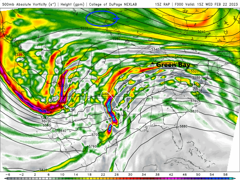
Figure 4 500 mb heights (contours) and vorticity (shaded). Primary disturbances denoted by the white ellipses. These disturbances in concert with the strong upper-level wind fields, interacted with a strong low-level temperature gradient to enhance vertical motion over Wisconsin generating several episodes of moderate to heavy snow. |
|
|
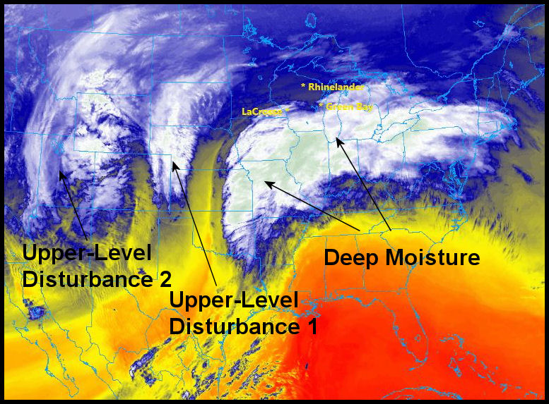
Figure 5 GOES-16 water vapor Image denoting primary weather features that contributed to long duration heavy snow event across the Western Great Lakes. As this image shows, the weather pattern was complex with several disturbances impacting the western Great Lakes over 2-3 day period. |
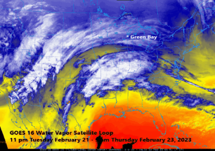
Figure 6 Animated GOES-16 water vapor imagery highlighting the evolution of the various weather features depicted in Figure 5. The flashes are lightning activity associated with thunderstorm activity as seen from the GOES-16 Lightning Mapper. |
|
|
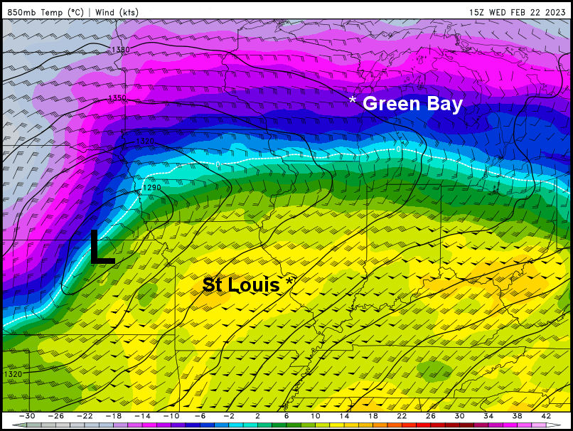
Figure 7 NAM 850 MB height (contours), wind (kts) and temperature (C). Image exemplifies the persistent and strong N-S temperature gradient (baroclinic zone) across the Great Lakes that helped set the stage for episodic heavy snow.
|
Figure 8 HREF mean precipitable water (inches) valid 13Z-18Z Wednesday February 22, 2023. Available moisture was well above normal for late February. |
Radar Overview
Below is a brief description of the radar evolution highlighting the three primary snowfall episodes associated with this prolonged winter storm.
|
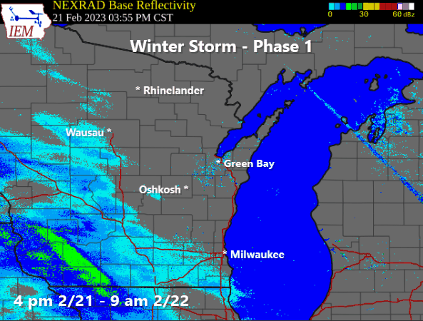
Figure 9 - Animation depicting the evolution of the radar echoes associated with the first stage of the winter storm that dumped 4-6 inches of snow across central and northeast Wisconsin primarily on Tuesday night February 21 into early morning Wednesday February 22. Winds were fairly light during this stage with little or no blowing or drifting snow. This rather narrow band of snow was associated with low-level frontogenetic forcing beneath a favorable (for upward motion) right-rear quadrant (RRQ) of a very strong level jet maximum. |
|
|
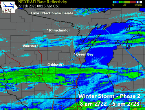
Figure 10 - Animation depicting evolution of radar echoes during phase 2 of the winter storm. This was the most intense phase of the winter storm that produced significant freezing rain and some sleet across far southern Wisconsin and periods of heavy snow across all of central, northcentral and northeast Wisconsin. Snowfall rates were 1-2 inches per hour at times. In addition, northeast winds intensified significantly during this phase with gust of 35-45 mph as the heaviest snow was falling late Wednesday night, creating near blizzard conditions. By the time Phase 2 was coming to an end by daybreak Thursday February 23, another widespread 8-12 inches of snow had fallen, closing business and schools across the area. |
|
|
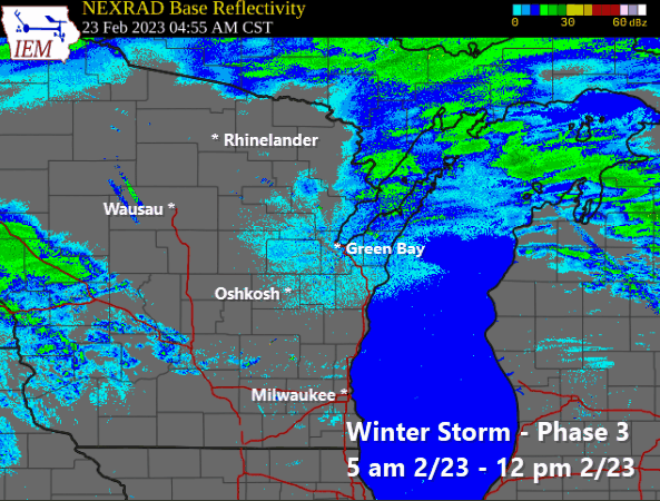
Figure 11 - Animation depicting the evolution of radar echoes during phase 3 of the winter storm that impacted mainly central, northcentral and far northeast Wisconsin. This final period of snow was associated with the primary upper-level disturbance (Disturbance #2) depicted in Figure 5 above. This disturbance although fairly strong, had less overall moisture to work with as it moved northeast across northern Wisconsin during the day on Thursday February 23. Regardless, still another 2 to 4 inches fell mainly over areas north of Highway 29 bringing storm total snowfall there closer to what was seen the previous evening across central and east-central Wisconsin. |
|
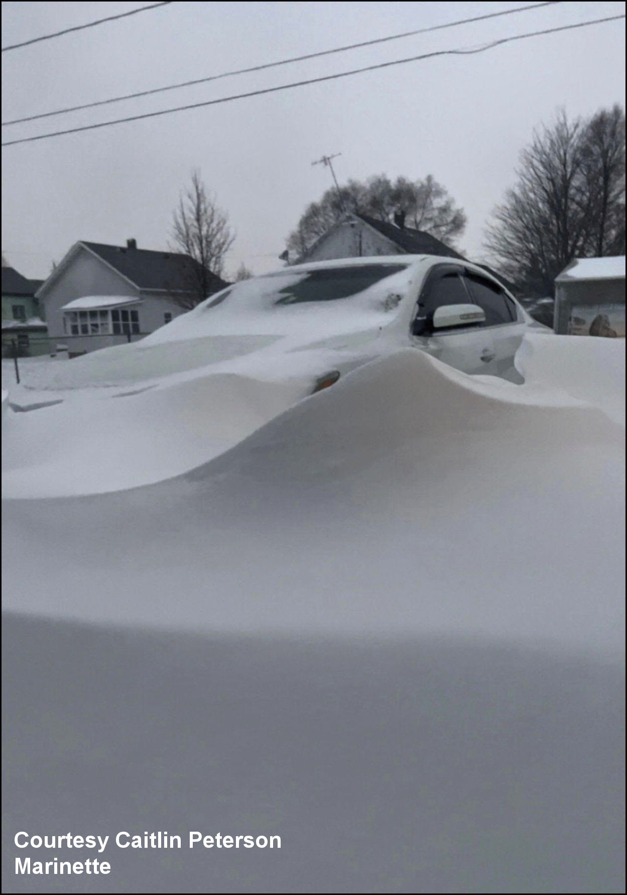
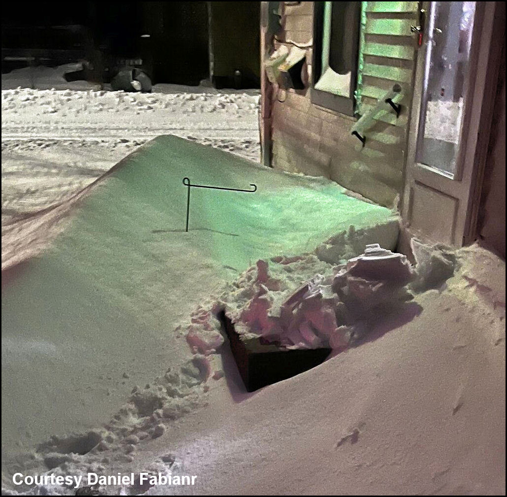
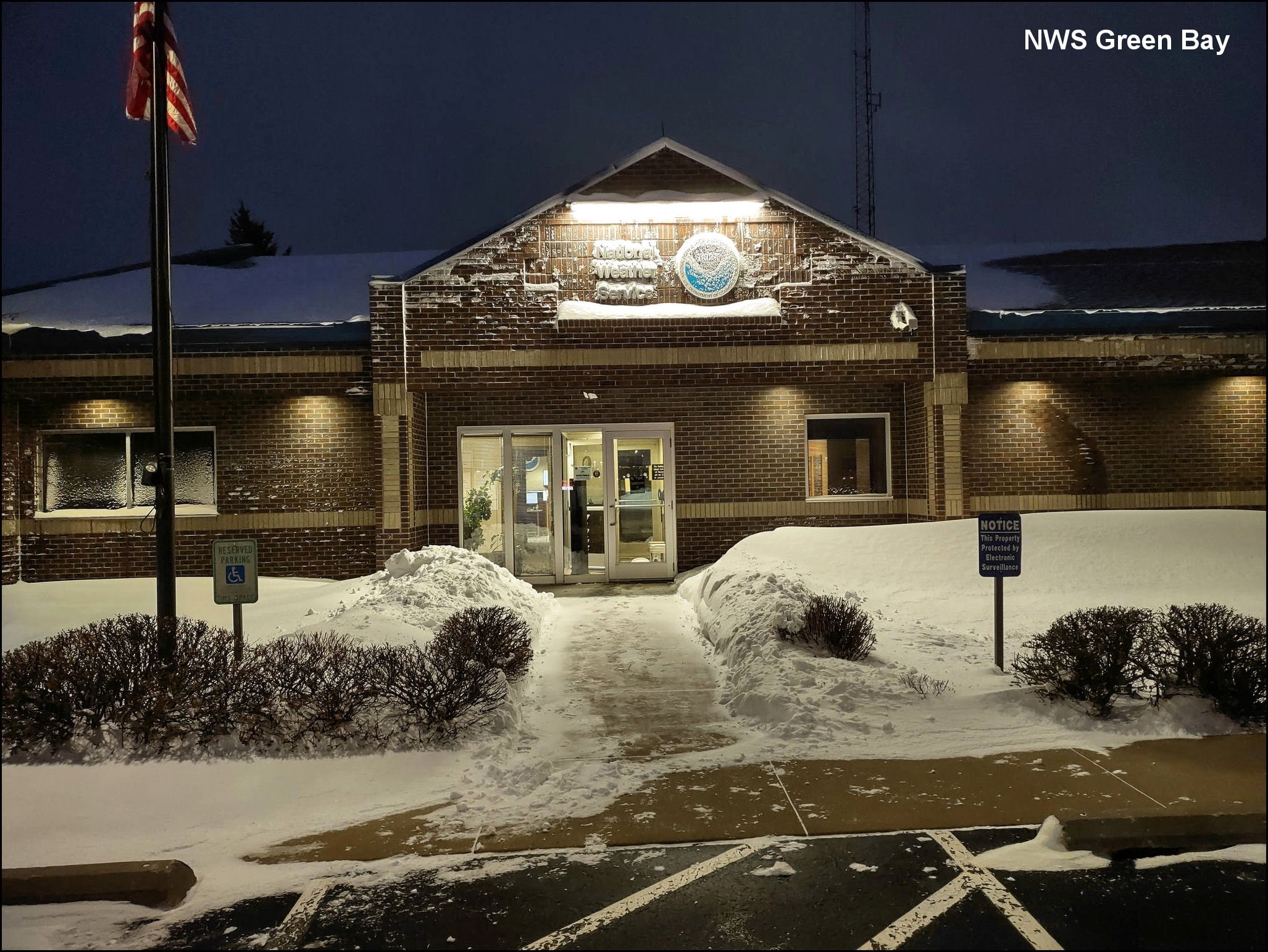
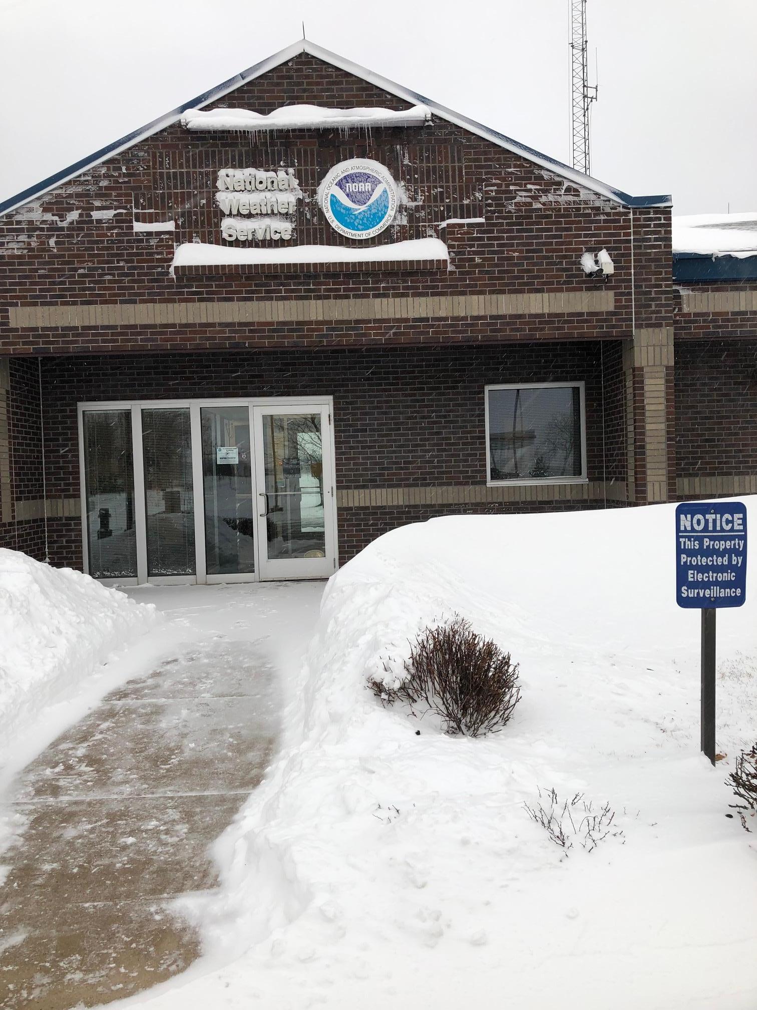
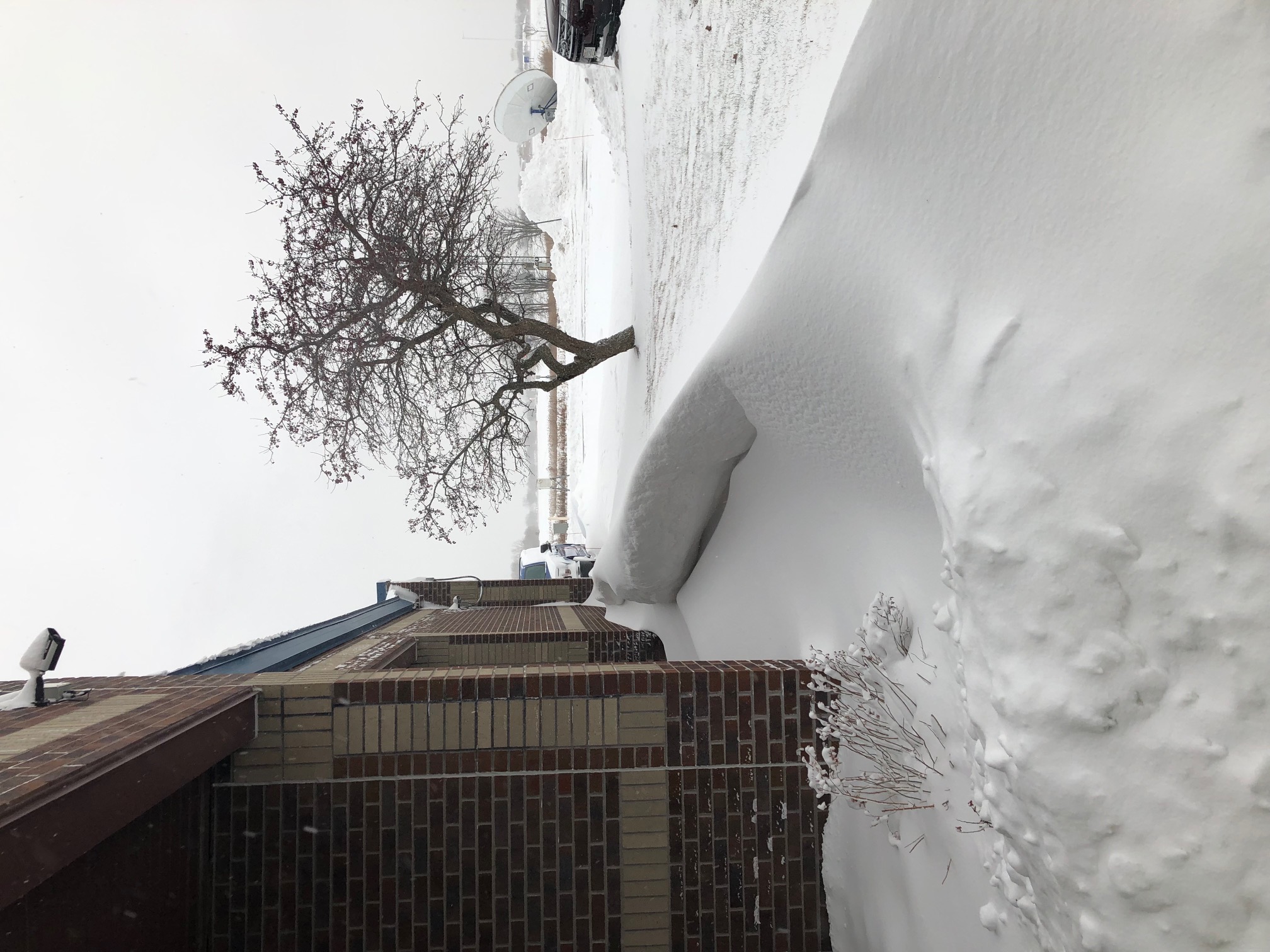
Photos
This summary may be updated as new information becomes available.
 |
Media use of NWS Web News Stories is encouraged! Please acknowledge the NWS as the source of any news information accessed from this site. |
|