Green Bay, WI
Weather Forecast Office
|
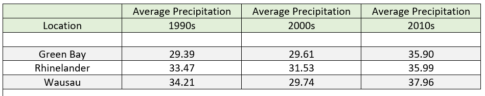
The 2010s will go down in the record books as the wettest decade on record across the state of Wisconsin. Three of the top five wettest years, and five of the top ten wettest years on record across the state occurred during the 2010s. The record precipitation brought an abrupt rise in water levels on the Great Lakes that haven’t been seen since the 1980s, finally reaching record levels in 2019. The high water levels resulted in coastal flooding during stronger storm events in 2019 along the Bay of Green Bay and Lake Michigan. Closer to home, Appleton has recorded seven of the top ten wettest years on record during the 2010s. Green Bay established a yearly precipitation record in 2018 with 39.21 inches. The ink was barely dry in the record books as Green Bay established another yearly precipitation record in 2019 with 47.87 inches of precipitation (*not including December 30 and 31), astoundingly breaking the old record by more than 8 inches. The combination of the above normal precipitation and water levels, combined with rapid snow melt led to record flooding on the East River in the Green Bay area, and the Kewaunee and Manitowoc Rivers during March 2019. Many other rivers across the area were also at flood stage during March into April. Many locations across north-central and northeast Wisconsin will record their wettest year on record.
|
 |
Media use of NWS Web News Stories is encouraged! Please acknowledge the NWS as the source of any news information accessed from this site. |
|
US Dept of Commerce
National Oceanic and Atmospheric Administration
National Weather Service
Green Bay, WI
2485 South Point Road
Green Bay, WI 54313-5522
920-494-2363
Comments? Questions? Please Contact Us.