|
A line of severe thunderstorms tracked across parts of central and east central Wisconsin during the afternoon hours of July 23. It brought a swath of damaging winds and heavy rain. Additional storms in the evening and overnight hours brought more rain to much of the area, except far northern Wisconsin. On Lake Winnebago, the gusty winds create a seiche, a temporary disturbance or oscillation in the water level of a lake or partially enclosed body of water, especially one caused by changes in atmospheric pressure. This caused the water to oscillate for several hours.
Please see the tabs below for more information. |
 |
Environmental Overview
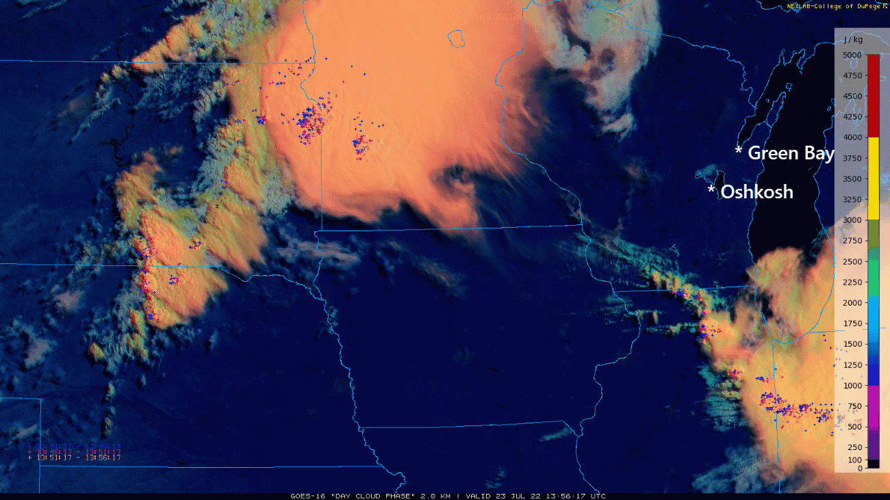 |
Enhanced Visible Image Animation. (7am – 7 pm July 23, 2022) Large convective complex organized over northeast North Dakota during early morning of Saturday July 23. Complex moved ESE across southern Minnesota and the southern half of Wisconsin during the day and intensified. Satellite detected lightning strikes over-laid. |
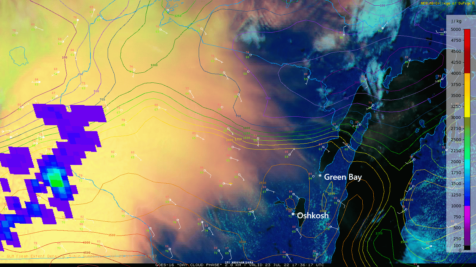 |
Enhanced Visible Image Animation over WI Mature convective complex moving east across the Green Bay forecast area with satellite-based lightning flashes near cloud top overlaid. Note: lake breeze advancing westward into the Fox Valley as storm complex approaches. Contours are CAPE (measure of instability). Instability was increasing across east-central Wisconsin during the day that contributed to storm intensification by mid-afternoon. |
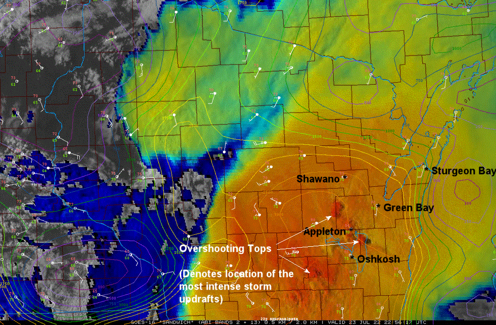 |
Sandwich RGB enhancement This enhanced image helps identify where the strongest overshooting tops (strongest storm updrafts are located). Note overshooting tops over the Fox Valley. This was about the time storms were the most intense as they moved across eastern Waushara, Winnebago and Outagamie counties. Damaging wind gusts were occurring at this time. |
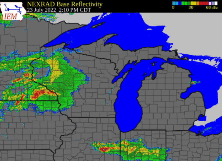 |
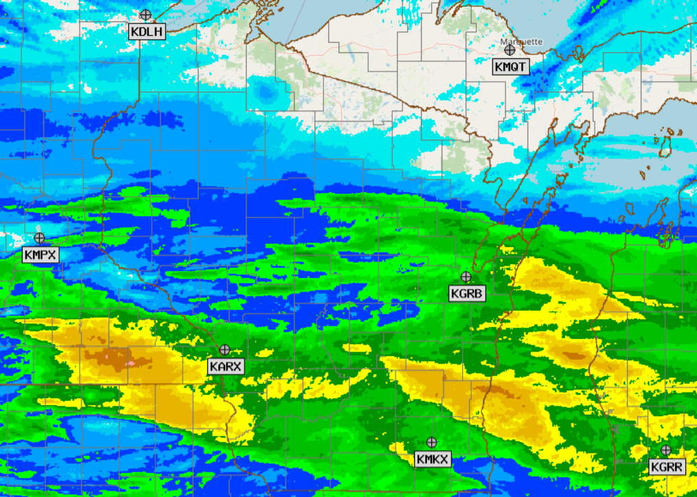
Animation of radar evolution Note gradual storm organization during the afternoon into an extensive squall-line with notable bow echo structure over east-central Wisconsin. The bowing radar structure that surged ENE across Fox Valley was associated with the widespread damaging wind gusts. |
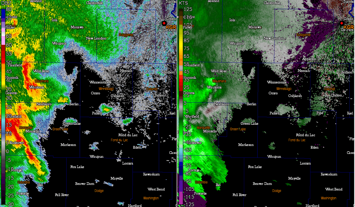 |
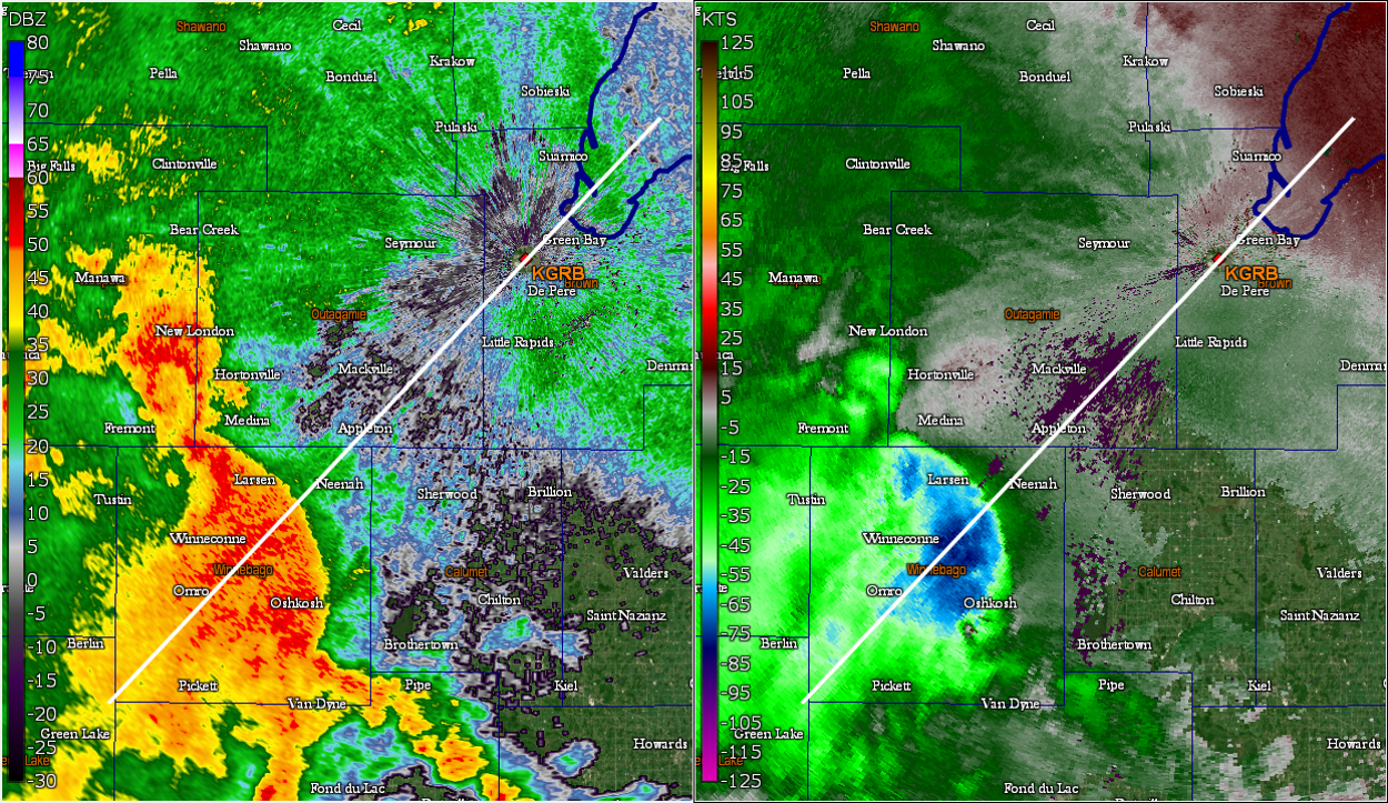
Animation of WFO GRB Doppler radar as storms surged across the Fox Valley and approached The Appleton and Oshkosh areas, including the EAA AirVenture area. Lowest level reflectivity (left) and low-level base velocity (right). Note the classic northeast surge of the radar echoes. The velocity data on the right shows the strong inbound velocity surge toward the northeast. Green Bay radar is located off the far northeast (upper-right) corner of the image. Darkest blue colors in the velocity data (right) denote radar-detected winds exceeding 75-80 mph just few thousand feet above the ground. |
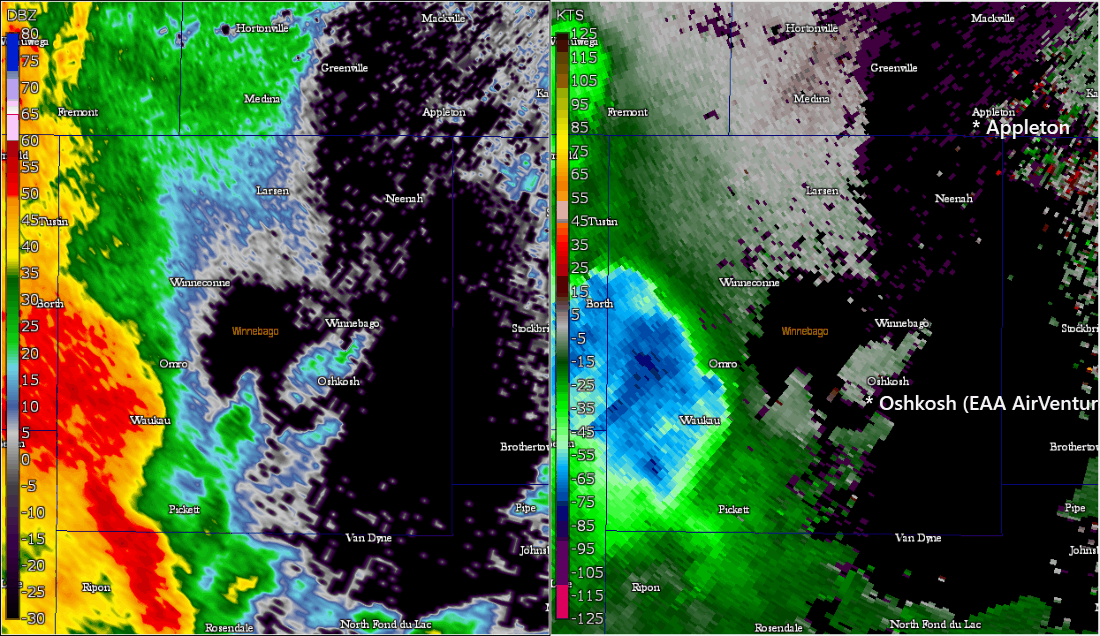 |
Animation of WFO GRB Doppler radar as storms surged across the Fox Valley and approached The Appleton and Oshkosh areas, including the EAA AirVenture area (zoomed in) Lowest level reflectivity (left) and low-level base velocity (right). Most intense line surge (denoted by blue colors in the velocity data on the right-hand image) passes just northwest of the Oshkosh area and the EAA AirVenture grounds. A plane was still flipped over at the grounds as the bow echo passed by. |
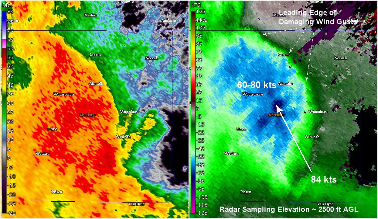 |
Still image of the strong winds Maximum winds near 84 kts were detected by the radar just a couple thousand feet (2000-2500 ft) above the ground at this time. Wind speeds near the surface ranged from 60 – 70+ mph at this time toppling trees and power lines. |
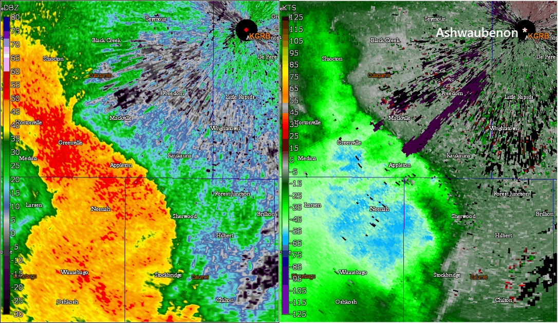 |
Radar animation as storms approached the city of Green Bay) several minutes later. Note that classic reflectivity surge toward the NE. Strongest inbound radial velocities (darker blue colors) with the bow echo surge had weakened somewhat as it surged directly toward the radar from Freedom to Green Bay, with maximum inbound radial velocities just above the surface of 55-60 mph. NWS Green Bay office (located just northwest of the strongest surge) measured a wind gust of 42 kts. The bow echo was moving into a somewhat more stable environment partly due to the fact that a lake breeze boundary had just moved west of the Green Bay, Appleton and I41 corridor areas several minutes earlier. |
|
|
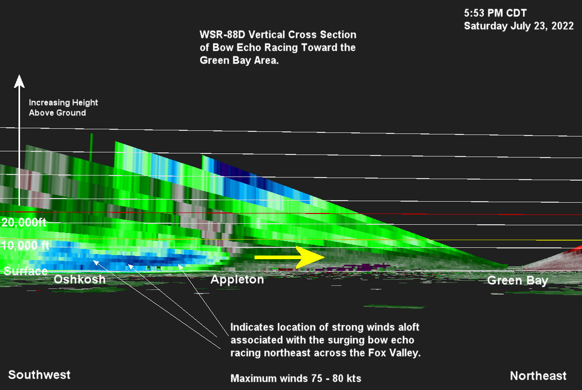
This is a vertical cross section taken along a line from Green Bay to southwest of Oshkosh. This perspective allows us to examine the 3-D velocity structure of the surging bow echo. Note the strong inbound velocities just above the surface between Oshkosh and Appleton. This feature is referred to as the rear inflow jet (RIJ). The RIJ is what causes the classic bowing structure (backwards “C” structure) often observed in the radar reflectivity. The storm was very close to the GRB radar, thus the radar was able to get a close look at the storm. |
Severe Reports / Map
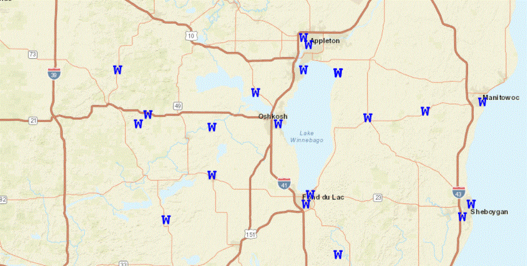 |
Storm reports from the local area W = Damaging wind |
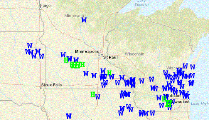 |
Storm reports from across the region W = Damaging wind |
PRELIMINARY LOCAL STORM REPORT...SUMMARY
NATIONAL WEATHER SERVICE GREEN BAY WI
853 PM CDT SAT JUL 23 2022

..TIME...   ...EVENT...      ...CITY LOCATION...     ...LAT.LON...
..DATE...   ....MAG....      ..COUNTY LOCATION..ST.. ...SOURCE....
            ..REMARKS..

0436 PM     HAIL             5 SW COLOMA             43.98N 89.59W
07/23/2022  U0.50 INCH       WAUSHARA           WI   PUBLIC

            REPORT FROM MPING: HALF-INCH (0.50 IN.).

0456 PM     TSTM WND GST     WAUTOMA                 44.06N 89.28W
07/23/2022  M38 MPH          WAUSHARA           WI   AWOS


0500 PM     TSTM WND DMG     SPRING LAKE             44.01N 89.16W
07/23/2022                   WAUSHARA           WI   PUBLIC

            CORRECTS PREVIOUS NON-TSTM WND DMG REPORT
            FROM SPRING LAKE. TWO TREES DOWN. REPORT VIA
            SOCIAL MEDIA. TIME ESTIMATED.

0520 PM     TSTM WND DMG     WILD ROSE               44.18N 89.25W
07/23/2022                   WAUSHARA           WI   PUBLIC

            REPORT AND PHOTO OF MID SIZED TREE DOWN IN
            THE MIDDLE OF DRIVEWAY. TIME APPROXIMATE.
            REPORT VIA SOCIAL MEDIA.

0521 PM     TSTM WND DMG     2 NNW LOHRVILLE         44.04N 89.12W
07/23/2022                   WAUSHARA           WI   PUBLIC

            TREES DOWN ON COUNTY HIGHWAY EE.

0528 PM     TSTM WND DMG     EUREKA                  44.00N 88.84W
07/23/2022                   WINNEBAGO          WI   PUBLIC

            TREES DOWN IN YARD. REPORT VIA SOCIAL MEDIA.
            TIME ESTIMATED BY RADAR.

0532 PM     TSTM WND DMG     OMRO                    44.03N 88.75W
07/23/2022                   WINNEBAGO          WI   PUBLIC

            REPORT ON SOCIAL MEDIA OF TREES AND POWER
            LINES DOWN. TIME ESTIMATED BY RADAR.

0535 PM     TSTM WND DMG     OMRO                    44.03N 88.75W
07/23/2022                   WINNEBAGO          WI   PUBLIC

            SEVERAL TREES AND POWER LINES DOWN. SEVERAL
            POWER POLES WERE SNAPPED.

0538 PM     TSTM WND DMG     WINNECONNE              44.11N 88.71W
07/23/2022                   WINNEBAGO          WI   PUBLIC

            CORRECTS PREVIOUS TSTM WND DMG REPORT FROM
            WINNECONNE. BRANCHES DOWN ALONG WITH A FEW
            TREES DOWN. REPORT FROM SOCIAL MEDIA. TIME
            ESTIMATED BY RADAR.

0542 PM     TSTM WND DMG     1 N BUTTE DES MORTS     44.11N 88.65W
07/23/2022                   WINNEBAGO          WI   PUBLIC

            NUMEROUS TREES DOWN.

0545 PM     TSTM WND GST     2 SSE GREENVILLE        44.26N 88.51W
07/23/2022  M53 MPH          OUTAGAMIE          WI   AWOS

            53 MPH WIND GUST REPORTED AT APPLETON
            INTERNATIONAL AIRPORT.

0550 PM     TSTM WND DMG     OSHKOSH                 44.01N 88.55W
07/23/2022                   WINNEBAGO          WI   PUBLIC

            TREES DOWN AROUND SCOTT STREET AND MAIN
            STREET IN OSHKOSH. TIME ESTIMATED BY RADAR.

0550 PM     TSTM WND DMG     NEENAH                  44.18N 88.44W
07/23/2022                   WINNEBAGO          WI   PUBLIC

            PHOTO AND REPORT OF TREE DOWN AND COVERING
            17TH AVENUE IN OSHKOSH. TIME ESTIMATED BY
            RADAR.

0550 PM     TSTM WND DMG     NEENAH                  44.18N 88.44W
07/23/2022                   WINNEBAGO          WI   PUBLIC

            PHOTO AND REPORT OF VERY LARGE TREE LIMB
            DOWN.

0550 PM     TSTM WND DMG     OSHKOSH                 44.01N 88.55W
07/23/2022                   WINNEBAGO          WI   PUBLIC

            REPORTS OF TREES AND POWER LINES DOWN ON
            10TH AVENUE IN OSHKOSH. REPORT VIA SOCIAL
            MEDIA. TIME ESTIMATED BY RADAR.

0550 PM     TSTM WND DMG     1 WSW WITTMAN FIELD     43.98N 88.56W
07/23/2022                   WINNEBAGO          WI   TRAINED SPOTTER

            PLANE FLIPPED AND TREE FELL ON CAR ON EAA
            GROUNDS.

0550 PM     TSTM WND GST     OSHKOSH                 44.01N 88.55W
07/23/2022  M68 MPH          WINNEBAGO          WI   PUBLIC

            MEASURED WIND GUST OFF HIGHWAY 45 IN
            OSHKOSH. SPOTTER NOTED A FEW TREES DOWN.
            TIME ESTIMATED BY RADAR.

0550 PM     TSTM WND DMG     OSHKOSH                 44.01N 88.55W
07/23/2022                   WINNEBAGO          WI   PUBLIC

            50 FOOT TALL WILLOWS DOWN ON POWER LINES.
            LINES DOWN ACROSS DRIVEWAY. WEST EDGE OF
            OSHKOSH ON SAND PIT ROAD. PHOTOS AND REPORTS
            VIA SOCIAL MEDIA. TIME ESTIMATED BY RADAR.

0550 PM     TSTM WND GST     WITTMAN FIELD           43.99N 88.56W
07/23/2022  M58 MPH          WINNEBAGO          WI   ASOS


0552 PM     TSTM WND DMG     2 WSW NEENAH            44.17N 88.47W
07/23/2022                   WINNEBAGO          WI   PUBLIC

            REPORT FROM MPING: 1-INCH TREE LIMBS BROKEN;
            SHINGLES BLOWN OFF.

0553 PM     TSTM WND DMG     1 SW WITTMAN FIELD      43.97N 88.56W
07/23/2022                   WINNEBAGO          WI   PUBLIC

            REPORT FROM MPING: 3-INCH TREE LIMBS BROKEN;
            POWER POLES BROKEN.

0554 PM     TSTM WND DMG     1 WSW APPLETON          44.26N 88.42W
07/23/2022                   OUTAGAMIE          WI   PUBLIC

            SEVERAL TREES DOWN ON THE SOUTHWEST SIDE OF
            APPLETON.

0555 PM     TSTM WND DMG     4 SSE GREENVILLE        44.24N 88.50W
07/23/2022                   WINNEBAGO          WI   PUBLIC

            APPROXIMATELY 15 INCH DIAMETER TREE SNAPPED.
            LOCATED IN FOX CROSSING WEST OF 41. REPORT
            AND PHOTO VIA SOCIAL MEDIA. TIME ESTIMATED
            BY RADAR.

0555 PM     TSTM WND DMG     OSHKOSH                 44.01N 88.55W
07/23/2022                   WINNEBAGO          WI   PUBLIC

            SMALL TREES BENT OVER. HEARD ONE TREE CRACK.
            ESTIMATED WIND GUSTS TO AROUND 60 MPH.
            LOCATED ABOUT 1.5 NW MILES FROM THE AIRPORT.

0558 PM     TSTM WND GST     2 WNW APPLETON          44.28N 88.44W
07/23/2022  E59 MPH          OUTAGAMIE          WI   PUBLIC


0603 PM     TSTM WND DMG     HIGH CLIFF STATE PARK   44.17N 88.29W
07/23/2022                   CALUMET            WI   PUBLIC

            A TREE FELL ONTO 2 CAMPERS AT HIGH CLIFF
            STATE PARK. TWO INJURIES WERE REPORTED.

0605 PM     TSTM WND DMG     2 NW STOCKBRIDGE        44.08N 88.33W
07/23/2022                   CALUMET            WI   PUBLIC

            STRONG THUNDERSTORM WINDS DESTROYED A DOCK
            ON LAKE WINNEBAGO.

0607 PM     TSTM WND GST     1 NW HIGH CLIFF STATE P 44.17N 88.29W
07/23/2022  M68 MPH          CALUMET            WI   TRAINED SPOTTER


0619 PM     HEAVY RAIN       3 WNW OSHKOSH           44.02N 88.60W
07/23/2022  M1.09 INCH       WINNEBAGO          WI   MESONET

            1.09 INCHES OF RAIN IN ABOUT 40 MINUTES.

0626 PM     TSTM WND GST     3 SSW ASHWAUBENON       44.42N 88.09W
07/23/2022  M55 MPH          BROWN              WI   TRAINED SPOTTER

            MEASURED 55 MPH WIND GUST. A FEW BRANCHES
            DOWN. LOCATED 3 MILES SW DE PERE.

0630 PM     FLOOD            2 SW NORTHPORT          44.38N 88.83W
07/23/2022                   WAUPACA            WI   PUBLIC

            REPORT AND PICTURE OF SOME FLOODING AT THE
            WOLF RIVER CAMPGROUND. REPORTED AROUND 630
            PM CDT, UNSURE WHEN FLOODING OFFICIALLY
            STARTED. REPORT VIA SOCIAL MEDIA.

0630 PM     TSTM WND DMG     CHILTON                 44.03N 88.16W
07/23/2022                   CALUMET            WI   PUBLIC

            REPORT FROM MPING: 3-INCH TREE LIMBS BROKEN;
            POWER POLES BROKEN.

0636 PM     TSTM WND DMG     2 WSW VALDERS           44.05N 87.91W
07/23/2022                   MANITOWOC          WI   PUBLIC

            POWER LINE DOWN.

0637 PM     TSTM WND DMG     2 NNE ASHWAUBENON       44.49N 88.07W
07/23/2022                   BROWN              WI   PUBLIC

            TREES DOWN IN THE 2200 BLOCK OF ONEIDA
            STREET.

0642 PM     TSTM WND GST     3 ESE ONEIDA            44.49N 88.13W
07/23/2022  M48 MPH          BROWN              WI   ASOS

            THUNDERSTORM WIND GUST TO 42 KNOTS AT KGRB
            AIRPORT.

0645 PM     TSTM WND DMG     MANITOWOC               44.08N 87.66W
07/23/2022                   MANITOWOC          WI   PUBLIC

            TREES DOWN. REPORT VIA SOCIAL MEDIA. TIME
            ESTIMATED BY RADAR.

0646 PM     TSTM WND GST     3 SW SHOTO              44.13N 87.68W
07/23/2022  M40 MPH          MANITOWOC          WI   AWOS


0647 PM     TSTM WND DMG     2 N MANITOWOC           44.11N 87.66W
07/23/2022                   MANITOWOC          WI   PUBLIC

            A FEW TREES DOWN ON THE NORTH SIDE OF
            MANITOWOC.

0649 PM     TSTM WND DMG     2 ESE ELLISVILLE        44.44N 87.64W
07/23/2022                   KEWAUNEE           WI   911 CALL CENTER

            TREES DOWN ON HIGHWAY 29 EAST OF TOWNLINE
            RD. TIME ESTIMATED BY RADAR.

0838 PM     HEAVY RAIN       2 NW TWO RIVERS         44.18N 87.58W
07/23/2022  M0.60 INCH       MANITOWOC          WI   PUBLIC


0845 PM     HEAVY RAIN       2 WNW WINNEBAGO         44.07N 88.54W
07/23/2022  M1.13 INCH       WINNEBAGO          WI   PUBLIC

            DELAYED REPORT.
Rainfall
 |
24-Hour Estimated Rainfall Several rounds of showers and thunderstorms brought heavy rain to parts of the state. The heaviest rain in our area fell across southern Door, Kewaunee and Manitowoc counites. The heaviest rain across the state fell over southern Wisconsin. |
PUBLIC INFORMATION STATEMENT
NATIONAL WEATHER SERVICE GREEN BAY WI
726 AM CDT SUN JUL 24 2022

...PRECIPITATION REPORTS LAST 24 HOURS...

LOCATION                     AMOUNT    TIME/DATE       LAT/LON

...WISCONSIN...

...BROWN COUNTY...
GREEN BAY AIRPORT            2.10 IN   0653 AM 07/24   44.48N/88.13W
DE PERE                      1.81 IN   0710 AM 07/24   44.44N/88.05W
NWS GREEN BAY                1.46 IN   0600 AM 07/24   44.50N/88.11W
GREEN BAY 1 WNW              1.38 IN   0709 AM 07/24   44.51N/88.01W

...CALUMET COUNTY...
BRILLION 4.9 S               1.68 IN   0700 AM 07/24   44.11N/88.05W
CHILTON 0.5 E                1.55 IN   0700 AM 07/24   44.03N/88.15W
CHILTON 1 W                  1.19 IN   0709 AM 07/24   44.03N/88.17W
NEW HOLSTEIN 1 W             1.15 IN   0710 AM 07/24   43.95N/88.10W
HILBERT 5.9 WSW              0.95 IN   0538 AM 07/24   44.11N/88.27W
APPLETON 4.6 ESE             0.87 IN   0647 AM 07/24   44.23N/88.32W
FOREST JUNCTION              0.72 IN   0708 AM 07/24   44.21N/88.21W

...DOOR COUNTY...
FORESTVILLE 4 E              1.94 IN   0700 AM 07/24   44.70N/87.40W
STURGEON BAY AIRPORT         1.30 IN   0710 AM 07/24   44.85N/87.42W
POTAWATOMI STATE PARK 3 SE   1.06 IN   0705 AM 07/24   44.83N/87.40W
POTAWATOMI STATE PARK 4 ESE  0.84 IN   0709 AM 07/24   44.83N/87.36W
1.9 NW CARLSVILLE            0.30 IN   0630 AM 07/24   44.97N/87.36W
EPHRAIM                      0.18 IN   0655 AM 07/24   45.13N/87.18W
SISTER BAY 1 N               0.10 IN   0700 AM 07/24   45.20N/87.11W
ELLISON BAY 1 ENE            0.07 IN   0700 AM 07/24   45.26N/87.03W
WASHINGTON ISLAND            0.02 IN   0545 AM 07/24   45.36N/86.89W

...FOREST COUNTY...
WABENO 2 NNW                 0.01 IN   0701 AM 07/24   45.46N/88.68W

...KEWAUNEE COUNTY...
LUXEMBURG 3.2 ESE            2.24 IN   0630 AM 07/24   44.53N/87.65W
2 E RANKIN                   2.10 IN   0710 AM 07/24   44.60N/87.44W
CASCO 0.4 NNW                1.93 IN   0600 AM 07/24   44.56N/87.62W
2 SSE DYCKESVILLE            1.58 IN   0533 AM 07/24   44.61N/87.74W

...LANGLADE COUNTY...
ANTIGO 2 ENE                 0.87 IN   0205 AM 07/24   45.16N/89.11W
ANTIGO AIRPORT               0.83 IN   0655 AM 07/24   45.15N/89.12W

...LINCOLN COUNTY...
MERRILL                      0.76 IN   0701 AM 07/24   45.18N/89.75W
MERRILL 8 W                  0.69 IN   0600 AM 07/24   45.18N/89.85W
MERRILL 7 W                  0.69 IN   0600 AM 07/24   45.18N/89.85W
TOMAHAWK 1.2 SSW             0.11 IN   0700 AM 07/24   45.46N/89.73W
TOMAHAWK 4.6 N               0.08 IN   0700 AM 07/24   45.54N/89.71W

...MANITOWOC COUNTY...
TWO RIVERS                   2.61 IN   0710 AM 07/24   44.15N/87.56W
TWO RIVERS                   2.50 IN   0700 AM 07/24   44.14N/87.57W
MANITOWOC                    2.01 IN   0708 AM 07/24   44.12N/87.64W
MANITOWOC AIRPORT            1.91 IN   0656 AM 07/24   44.12N/87.67W
TWO RIVERS 2 NW              1.82 IN   0624 AM 07/24   44.18N/87.58W
MANITOWOC 1.4 NW             1.80 IN   0700 AM 07/24   44.11N/87.69W
MANITOWOC                    1.79 IN   0709 AM 07/24   44.08N/87.68W
ST NAZIANZ                   1.70 IN   0710 AM 07/24   44.01N/87.89W
TWO RIVERS 4.1 WNW           1.65 IN   0600 AM 07/24   44.19N/87.65W
WHITELAW                     1.60 IN   0710 AM 07/24   44.18N/87.84W
SHOTO 1 NW                   1.60 IN   0700 AM 07/24   44.17N/87.67W
MANITOWOC                    1.23 IN   0710 AM 07/24   44.09N/87.66W
REEDSVILLE                   1.07 IN   0701 AM 07/24   44.23N/87.96W
MANITOWOC                    0.95 IN   0707 AM 07/24   44.11N/87.69W
MILLHOME 2 E                 0.94 IN   0617 AM 07/24   43.90N/87.91W

...MARATHON COUNTY...
MOSINEE 2 W                  1.18 IN   0700 AM 07/24   44.77N/89.73W
MOON 6 SW                    1.09 IN   0205 AM 07/24   44.70N/89.87W
WAUSAU AIRPORT               1.08 IN   0654 AM 07/24   44.93N/89.62W
MOSINEE                      0.51 IN   0701 AM 07/24   44.86N/89.68W
WAUSAU                       0.51 IN   0709 AM 07/24   44.95N/89.64W
WAUSAU 1 SSE                 0.50 IN   0710 AM 07/24   44.94N/89.62W
STRATFORD 4 W                0.48 IN   0705 AM 07/24   44.81N/90.17W
WAUSAU                       0.45 IN   0702 AM 07/24   44.95N/89.61W
STRATFORD 1 NW               0.35 IN   0628 AM 07/24   44.82N/90.09W
WAUSAU WSAW TV               0.30 IN   1120 PM 07/23   44.95N/89.62W

...MARINETTE COUNTY...
PESHTIGO 1 N                 0.19 IN   0710 AM 07/24   45.06N/87.75W
CRIVITZ 1 ESE                0.15 IN   0710 AM 07/24   45.23N/88.00W
AMBERG 9 E                   0.02 IN   0630 AM 07/24   45.48N/87.81W
ATHELSTANE 2 SW              0.02 IN   0710 AM 07/24   45.40N/88.12W
ATHELSTANE 1.6 E             0.02 IN   0600 AM 07/24   45.42N/88.06W

...MENOMINEE COUNTY...
KESHENA 4 NE                 0.70 IN   0710 AM 07/24   44.92N/88.57W
KESHENA 2 WNW                0.55 IN   0205 AM 07/24   44.89N/88.66W

...OCONTO COUNTY...
OCONTO AIRPORT               1.03 IN   0555 AM 07/24   44.87N/87.92W
MOUNTAIN                     0.47 IN   0708 AM 07/24   45.17N/88.44W
BREED 5 NE                   0.43 IN   0703 AM 07/24   45.12N/88.37W
MOUNTAIN 0.9 E               0.27 IN   0700 AM 07/24   45.18N/88.46W
TOWNSEND 1.7 NNW             0.13 IN   0600 AM 07/24   45.35N/88.61W
LAKEWOOD                     0.06 IN   0700 AM 07/24   45.31N/88.47W

...ONEIDA COUNTY...
BRADLEY 2 NNW                0.04 IN   0708 AM 07/24   45.56N/89.77W
RHINELANDER AIRPORT          0.04 IN   0653 AM 07/24   45.63N/89.48W
RHINELANDER                  0.04 IN   1030 PM 07/23   45.62N/89.41W
TOMAHAWK 3 W                 0.04 IN   0510 AM 07/24   45.59N/89.72W
MINOCQUA 2 ESE               0.03 IN   0705 AM 07/24   45.84N/89.65W

...OUTAGAMIE COUNTY...
GRAND CHUTE                  1.31 IN   0709 AM 07/24   44.31N/88.42W
APPLETON                     1.30 IN   0500 AM 07/24   44.28N/88.44W
MACKVILLE 2 S                1.16 IN   0545 AM 07/24   44.31N/88.41W
APPLETON                     1.07 IN   0207 AM 07/24   44.29N/88.46W
KAUKAUNA 1 W                 0.97 IN   0430 AM 07/24   44.26N/88.29W
NEW LONDON 4.1 N             0.94 IN   0600 AM 07/24   44.45N/88.73W
KAUKAUNA                     0.92 IN   0700 AM 07/24   44.25N/88.28W
GREENVILLE                   0.92 IN   0707 AM 07/24   44.29N/88.52W
SEYMOUR                      0.82 IN   0705 AM 07/24   44.54N/88.25W


...PORTAGE COUNTY...
AMHERST 3 SE                 0.80 IN   0700 AM 07/24   44.41N/89.26W
STEVENS POINT AIRPORT        0.68 IN   0655 AM 07/24   44.55N/89.53W

...SHAWANO COUNTY...
CECIL                        1.75 IN   0702 AM 07/24   44.85N/88.35W
SHAWANO AIRPORT              1.07 IN   0715 AM 07/24   44.78N/88.57W

...VILAS COUNTY...
ARBOR VITAE-JOHNSON LAKE     0.02 IN   0602 AM 07/24   45.90N/89.73W

...WAUPACA COUNTY...
OGDENSBURG 2 E               1.32 IN   0700 AM 07/24   44.46N/88.98W
NEW LONDON 1 SW              1.28 IN   0710 AM 07/24   44.37N/88.76W
IOLA 0.4 SSW                 1.05 IN   0500 AM 07/24   44.50N/89.13W
WAUPACA                      0.92 IN   0655 AM 07/24   44.33N/89.02W
WAUPACA                      0.75 IN   0707 AM 07/24   44.34N/89.11W

...WAUSHARA COUNTY...
WILD ROSE 0.5 E              1.09 IN   0600 AM 07/24   44.18N/89.24W
WAUTOMA 1 WSW                0.72 IN   0512 AM 07/24   44.06N/89.29W

...WINNEBAGO COUNTY...
OMRO 1 WSW                   1.46 IN   0700 AM 07/24   44.02N/88.78W
OSHKOSH AIRPORT              1.15 IN   0704 AM 07/24   43.97N/88.55W
MENASHA 0.3 W                1.03 IN   0700 AM 07/24   44.21N/88.44W

...WOOD COUNTY...
VESPER                       0.68 IN   0707 AM 07/24   44.47N/89.95W
RUDOLPH                      0.57 IN   0710 AM 07/24   44.50N/89.79W
WISCONSIN RAPIDS             0.53 IN   0700 AM 07/24   44.40N/89.83W
MARSHFIELD AIRPORT           0.39 IN   0654 AM 07/24   44.63N/90.18W
WISCONSIN RAPIDS             0.38 IN   0700 AM 07/24   44.37N/89.77W
WISCONSIN RAPIDS AIRPORT     0.37 IN   0654 AM 07/24   44.37N/89.83W
NEW ROME 4 ENE               0.34 IN   0205 AM 07/24   44.26N/89.81W

OBSERVATIONS ARE COLLECTED FROM A VARIETY OF SOURCES WITH VARYING
EQUIPMENT AND EXPOSURES. WE THANK ALL VOLUNTEER WEATHER OBSERVERS
FOR THEIR DEDICATION. NOT ALL DATA LISTED ARE CONSIDERED OFFICIAL.
Lake Winnebago Seiche
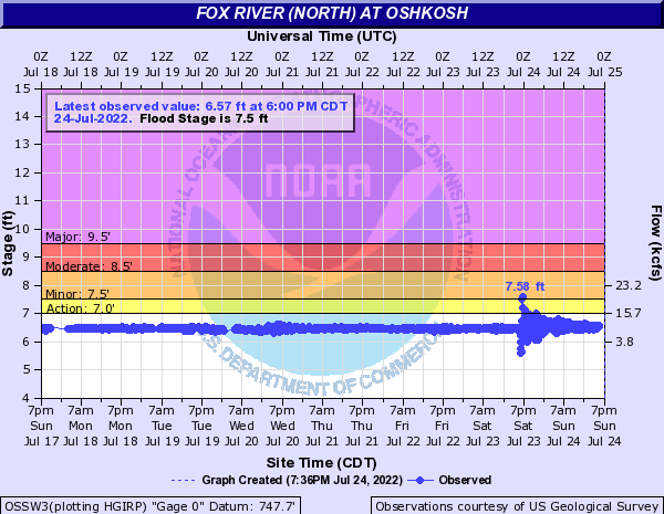 |
Fox River at Oshkosh Hydrograph The water levels on Lake Winnebago
The minimum level recorded was 5.65 feet at 6:45 pm, with the maximum level of 7.58 feet occurring just 20 minutes later at 7:05 pm.
For more info on seiches, visit: |
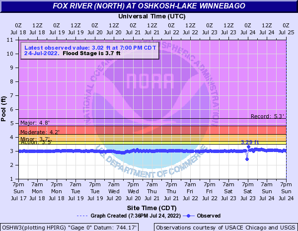 |
Fox River at Oshkosh Hydrograph Here is a look at another nearby gauge. Only about a foot change here. |
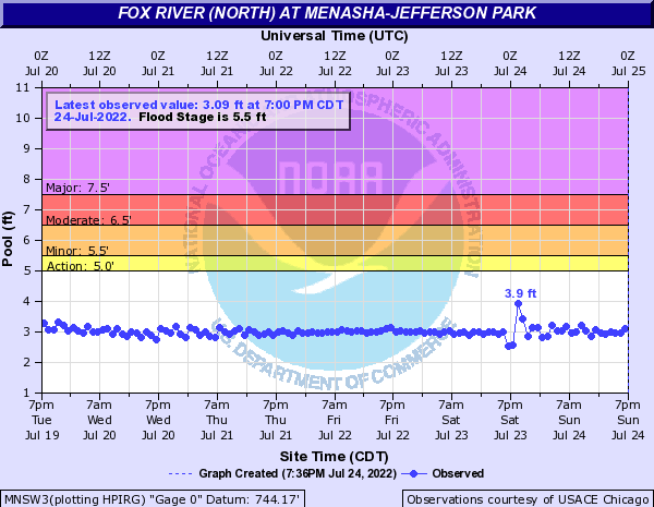 |
Fox River at Menasha - Here is a look at another nearby gauge. About a foot change here as well. |
 |
Media use of NWS Web News Stories is encouraged! Please acknowledge the NWS as the source of any news information accessed from this site. |
|