Flooding & Severe Weather July 14-15, 2021
|
Several rounds of showers and thunderstorms cross northeast Wisconsin the Wednesday afternoon, July 14 and continued into the early morning hours of Thursday, July 15.
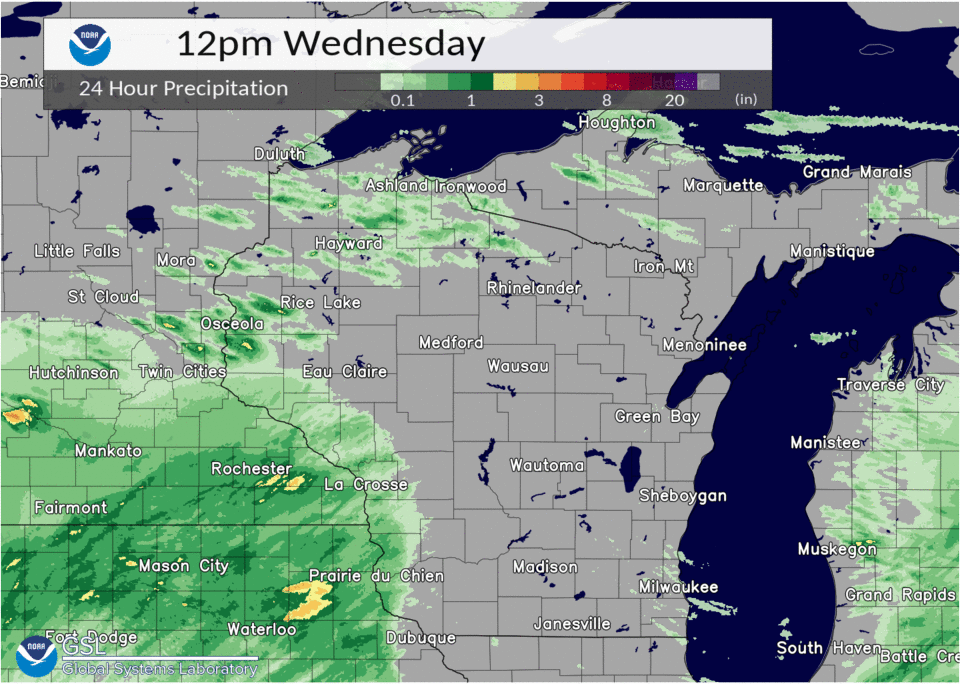
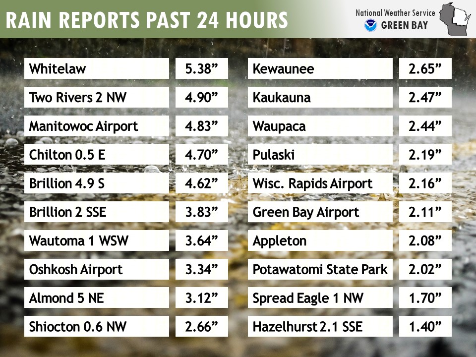
The first round of thunderstorms produced isolated damaging wind gusts late in the afternoon over east-central Wisconsin. Several downed trees were reported over the northwest portion of Manitowoc county shortly after 4 pm. However, the most significant impacts revolved around heavy rainfall and flooding. Thunderstorms trained over the area from Waushara and Waupaca to Manitowoc and Two Rivers late in the evening into the overnight hours.
The end result was a swath of heavy rainfall in the range of 3 to 6 inches in that area. The highest rainfall were reported from Whitelaw in Manitowoc county (5.38 inches), Two Rivers (4.90 inches), and Manitowoc (4.83 inches). The heavy rainfall created flooded roads, parking lots, and basements, caused the Manitowoc River to overflow its banks.
See tabs below for more information. Click on any image for a larger view. |
.jpg.png) |
Overview / Satellite
|
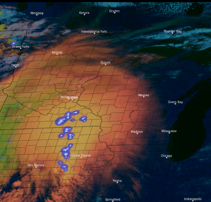
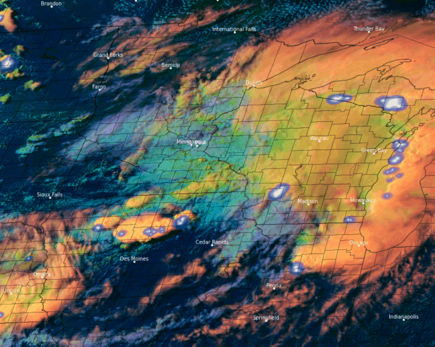
Composite Satellite Animation of Storms Wednesday morning
|
The animation shows a large, well-organized storm complex approaching Wisconsin. At this time the complex, although very large and producing lots of lightning activity, was only able to muster a few sub-severe winds gusts with no damage reported. The brightest orange colors represent a very thick and vertically deep cloud shield associated with this complex. The darker orange colors represent a much thinner veil of upper-level wispy cirrus clouds, also referred to as thunderstorm cirrus blow-off. The whitish or cream colored clouds over Lake Superior and along the UP/WI border are low-level clouds. Note that much of eastern Wisconsin started out the day sunny, with a gradual increase in thin wispy cirrus clouds. One of the forecast challenges during the morning was determining whether the large convective complex crossing the Mississippi River would re-intensify as it approached eastern Wisconsin. A key often used to help answer this question is to assess whether there will be enough sunshine to allow the atmosphere to destabilize appreciably before the thicker clouds moved in. This can be quite a challenge sometimes! The lightning data shows a broken line, with small pockets of more persistent lightning flashes associated with the leading line of strongest thunderstorm activity (see radar animations). These are typically accompanied by frequent dangerous cloud-to-ground strikes. This region is typically where the strong or damaging wind gusts and heavy rain rates occur. Note the occasional BIG flashes behind the leading line of storms. These flashes cover a much larger area, within the less intense portion of the complex, that brought mainly widespread light to moderate rainfall. Typically, these flashes occur within the cloud, but occasionally also generate dangerous cloud to ground strikes! That is why it is so important to always remember deadly (cloud-to-ground ) lightning is still possible both after the initial gusty winds and heavy rain and even after the worst of the storm has ended. If thunder roars, stay indoors! |
|
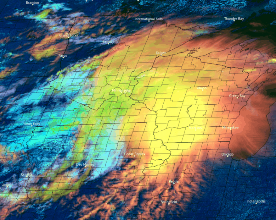
Composite Satellite Animation of Storms Wednesday afternoon (19Z – 23Z). Its all about timing…
|
The main point of this next animation is to show how the storm top cloud characteristics changed as the thunderstorm complex approached eastern Wisconsin later in the afternoon. Lightning flashes were removed so you could more easily observe the cloud top characteristics. Initially, the visible cloud top characteristics associated with the storm complex over western and central Wisconsin are both very bright (indicating thick and deep clouds), and also very smooth with very little texture noted. At the end of the animation however, we see the rapid appearance of much more textured lumpiness in the cloud top. This suggests re-intensification of the storms along the leading edge of the complex. One contributing factor as to why this occurred is the fact that eastern Wisconsin started out with sunshine or just a very thin shield of high clouds which still allowed enough sunshine to destabilize the atmosphere. The more unstable (buoyant) the airmass is ahead of the complex, the greater the likelihood of more robust updrafts. These pre-existing updrafts were able to intensify and accelerate vertically above the broader cirrus canopy below. It should also be noted that toward the end of the animation, the sun is beginning to set to the west. Thus, the taller individual updraft cores are casting shadows on the clouds below. Although no severe wind gusts or damage were reported for much of the day with this complex, numerous reports of large branches and a few trees blown down began to be reported from Green Bay south to Manitowoc, generally along and east of the I-41 corridor. Had the atmosphere had a few more hours to destabilize before the clouds moved in, these storms could have been much stronger potentially producing more widespread tree damage. That was not the case in Iowa, however where there was more sunshine (and much more buoyant air in place.) This resulted in explosive supercell thunderstorm development there. |
|
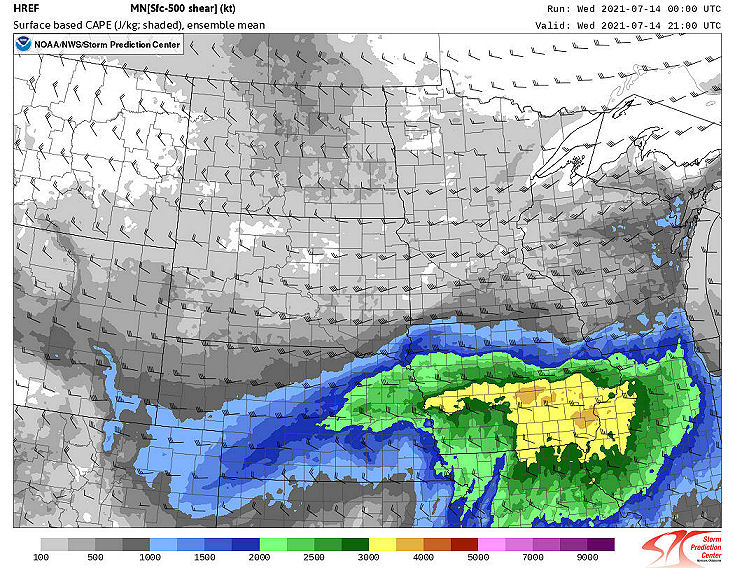
HREF Mean Forecast Surface-based CAPE and mean surface to 500 mb shear vectors. Valid 21 UTC Wednesday July 14, 2021. |
Convective Available Potential Energy (CAPE) is a measure of the buoyancy in the atmosphere. The greater (stronger) the buoyancy, the greater the potential for very strong storm updrafts. The areas shaded in the green to dark yellow colors indicate the region where the strongest updrafts are most likely (assuming of course that storms can actually develop). Clearly the most vulnerable area for intense storms, based on this model forecast, would be over much of Iowa and into far western Illinois. Note that although more modest compared to Iowa, the largest buoyancy potential (CAPE) was over eastern Wisconsin (recall previous satellite discussion). Although modest, this was a sufficient amount of CAPE to help strengthen the storms there. All the pre-exiting updrafts needed was a little kicker to help them intensify. In contrast, over Iowa, the combination of very high CAPE and sufficient deep layer shear (in concert with an approaching cold front) led to an outbreak of several intense supercells. |
|
Composite Satellite Animation of Storms (23Z – 03Z) with GLM lightning flashes. Its all about timing again (round 2)… |
This animation begins near sunset and continues after dark until about 03Z (10 pm CDT). First note the explosive thunderstorm development over Iowa where numerous tornadoes, large hail, damaging winds and torrential rainfall was reported. Note how the storm coverage rapidly expands northeast across the southeast half of Wisconsin. Fortunately for communities across east-central Wisconsin and the adjacent lakeshore, timing was again in our favor, at least with respect to damaging supercell thunderstorms. Once the sun set, the atmosphere started to quickly become less volatile (less buoyant) during the evening hours. This contributed to a transition from more discrete and severe supercell storms, to a larger and more expansive area of strong (and considerably less severe) thunderstorms that spread northeast into east-central Wisconsin. Unfortunately, the event was now transitioning into heavy rainfall and flash flood scenario. Why was that? |
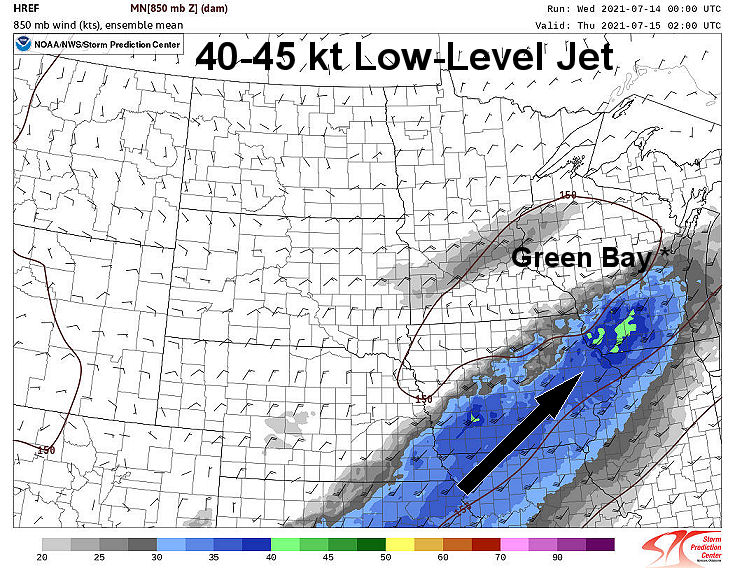 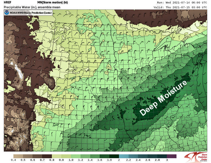 |
Two important ingredients came together over east-central Wisconsin that contributed to a long duration and highly efficient rainfall-producing thunderstorms later that evening. The first ingredient was the development of a strong low-level wind maximum (top image) otherwise referred to as a low-level jet (LLJ). East-central Wisconsin was near the nose of the LLJ, which is an area of strong low-level mass convergence that results in strong mesoscale lifting. The second ingredient was the presence of copious moisture in the atmosphere over northeast Wisconsin. The second image is a measure of the amount of moisture in the atmosphere referred to as Precipitable Water (PW). Values were forecast to approach 2.0 inches which is close to the climatological maximum for this time of year. The LLJ rapidly transported very deep moisture into the area. The combination of deep moisture and persistent large-scale lifting near the nose of the LLJ led to repeated development of thunderstorms that were very efficient rainfall producers! This ultimately resulted in overnight rainfall totals in the 4-6 inch range over parts of east-central Wisconsin to the lakeshore. |
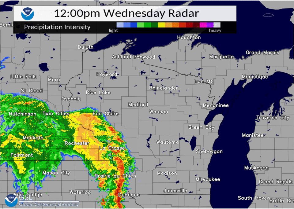
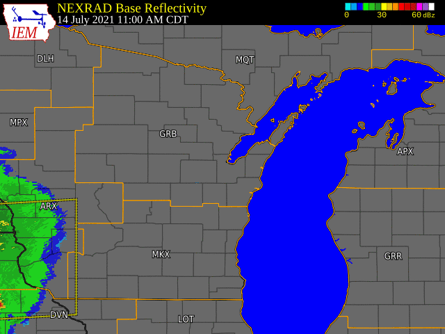
Radar
Rainfall / Severe Reports
|
|
Hour by hour radar estimated rainfall totals |
|
|
See below for a full listing of rainfall totals |
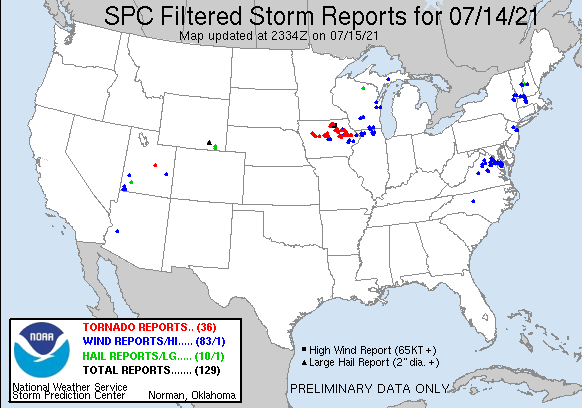 |
...24 HOUR PRECIPITATION REPORTS...

LOCATION                     AMOUNT    TIME/DATE       PROVIDER

...WISCONSIN...

...BROWN COUNTY...
DENMARK WWTP                 2.79 IN   0800 AM 07/15   COOP
GREEN BAY                    2.74 IN   0934 AM 07/15   CWOP
GREEN BAY 7.1 WNW            2.31 IN   0700 AM 07/15   COCORAHS
GREEN BAY 1 ESE              2.16 IN   0935 AM 07/15   AWS
GREEN BAY AIRPORT            2.11 IN   0916 AM 07/15   ASOS
GREEN BAY BOTANICAL GARDEN   2.11 IN   0700 AM 07/15   COOP
GREEN BAY                    2.11 IN   0600 AM 07/15   COOP
GREEN BAY 3.8 SSE            2.10 IN   0700 AM 07/15   COCORAHS
WRIGHTSTOWN 4 NNE            2.04 IN   0530 AM 07/15   COCORAHS
DENMARK 1 NNE                2.00 IN   0940 AM 07/15   AWS
DE PERE                      2.00 IN   0930 AM 07/15   CWOP
CHAMPION 1 NNW               1.94 IN   0745 AM 07/15   COCORAHS
WRIGHTSTOWN                  1.93 IN   0936 AM 07/15   CWOP
WRIGHTSTOWN 0.4 ENE          1.84 IN   0700 AM 07/15   COCORAHS
DE PERE                      1.75 IN   0940 AM 07/15   CWOP
SUAMICO 4.4 WNW              1.73 IN   0700 AM 07/15   COCORAHS
GREEN BAY                    1.57 IN   0932 AM 07/15   CWOP
GREEN BAY 1 WNW              1.49 IN   0939 AM 07/15   AWS

...CALUMET COUNTY...
CHILTON 0.5 E                4.70 IN   0700 AM 07/15   COOP
BRILLION 4.9 S               4.62 IN   0700 AM 07/15   COCORAHS
HILBERT 5.9 WSW              3.71 IN   0507 AM 07/15   COCORAHS
BRILLION                     3.70 IN   0730 AM 07/15   COOP
NEW HOLSTEIN 1 W             2.94 IN   0940 AM 07/15   AWS
CHILTON 1 W                  2.86 IN   0939 AM 07/15   AWS
DARBOY 3 SE                  2.70 IN   0700 AM 07/15   COCORAHS
FOREST JUNCTION              2.63 IN   0938 AM 07/15   CWOP
MENASHA 4.0 E                2.56 IN   0630 AM 07/15   COCORAHS
MENASHA 2.4 E                2.36 IN   0700 AM 07/15   COCORAHS

...DOOR COUNTY...
POTAWATOMI STATE PARK 3 SE   2.02 IN   0935 AM 07/15   AWS
BRUSSELS 3 N                 1.95 IN   0700 AM 07/15   COCORAHS
FORESTVILLE 4 E              1.79 IN   0700 AM 07/15   UCOOP
STURGEON BAY EXP FARM        1.68 IN   0730 AM 07/15   COOP
1.9 NW CARLSVILLE            1.52 IN   0630 AM 07/15   UCOOP
POTAWATOMI STATE PARK 4 ESE  1.36 IN   0939 AM 07/15   AWS
BAILEYS HARBOR 3 ENE         1.21 IN   0700 AM 07/15   COCORAHS
FISH CREEK 1 E WWTP          1.05 IN   0430 AM 07/15   UCOOP
FISH CREEK 0.1 SSE           1.05 IN   0700 AM 07/15   COCORAHS
EPHRAIM 1 NE - WWTP          0.89 IN   0715 AM 07/15   COOP
ELLISON BAY 1 ENE            0.89 IN   0700 AM 07/15   COCORAHS
FISH CREEK 3 S - JUDDVILLE   0.83 IN   0800 AM 07/15   UCOOP
SISTER BAY 1 N               0.83 IN   0600 AM 07/15   COCORAHS
WASHINGTON ISLAND            0.82 IN   0530 AM 07/15   COOP
WASHINGTON ISLAND            0.79 IN   0935 AM 07/15   AWOS
WASHINGTON ISLAND 1 WSW      0.52 IN   0940 AM 07/15   AWS

...FLORENCE COUNTY...
SPREAD EAGLE 1 NW            1.70 IN   0700 AM 07/15   COCORAHS

...FOREST COUNTY...
ARGONNE 1.5 NW               0.73 IN   0700 AM 07/15   COOP
CRANDON                      0.41 IN   0931 AM 07/15   CWOP
WABENO 2 NNW                 0.39 IN   0901 AM 07/15   RAWS
WABENO 2 NNW                 0.36 IN   0939 AM 07/15   AWS

...KEWAUNEE COUNTY...
CASCO 0.4 NNW                2.76 IN   0550 AM 07/15   COCORAHS
KEWAUNEE                     2.65 IN   0700 AM 07/15   COOP
LUXEMBURG 3.2 ESE            2.52 IN   0200 AM 07/15   COCORAHS
2 E RANKIN                   1.38 IN   0940 AM 07/15   AWS

...LANGLADE COUNTY...
WHITE LAKE 1.4 SE            0.89 IN   0800 AM 07/15   COOP
SUMMIT LAKE                  0.75 IN   0500 AM 07/15   COOP
ANTIGO AIRPORT               0.71 IN   0935 AM 07/15   AWOS
ANTIGO 1 SSW                 0.70 IN   0800 AM 07/15   COOP
ANTIGO 2 ENE                 0.67 IN   0905 AM 07/15   RAWS

...LINCOLN COUNTY...
TOMAHAWK 4.6 N               0.90 IN   0700 AM 07/15   COCORAHS
MERRILL 8 W                  0.79 IN   0600 AM 07/15   UCOOP
MERRILL 7 W                  0.79 IN   0600 AM 07/15   COCORAHS
MERRILL                      0.70 IN   0933 AM 07/15   CWOP
MERRILL 14.1 W               0.69 IN   0600 AM 07/15   COCORAHS
2.7 NE SPIRIT FALLS          0.60 IN   0830 AM 07/15   UCOOP
TOMAHAWK 1.2 SSW             0.51 IN   0700 AM 07/15   COCORAHS

...MANITOWOC COUNTY...
WHITELAW                     5.38 IN   0940 AM 07/15   CWOP
TWO RIVERS 2 NW              4.90 IN   0431 AM 07/15   COCORAHS
MANITOWOC AIRPORT            4.83 IN   0922 AM 07/15   AWOS
TWO RIVERS 0.9 SE            4.71 IN   0700 AM 07/15   COCORAHS
TWO RIVERS                   4.70 IN   0700 AM 07/15   COOP
MISHICOT 0.1 NNW             4.30 IN   0800 AM 07/15   COCORAHS
MANITOWOC                    4.17 IN   0938 AM 07/15   CWOP
TWO RIVERS 4.1 WNW           4.14 IN   0530 AM 07/15   COCORAHS
MILLHOME 2 E                 4.13 IN   0635 AM 07/15   COCORAHS
BRILLION 2 SSE               3.83 IN   0800 AM 07/15   COCORAHS
SHOTO 1 NW                   3.70 IN   0700 AM 07/15   COCORAHS
REEDSVILLE                   2.42 IN   0931 AM 07/15   CWOP

...MARATHON COUNTY...
WAUSAU 3.9 SSW               1.24 IN   0600 AM 07/15   COCORAHS
DANCY 1 NNW                  1.14 IN   0500 AM 07/15   COCORAHS
WAUSAU 1 ENE                 0.96 IN   0700 AM 07/15   COCORAHS
MOON 1 E                     0.95 IN   0500 AM 07/15   COOP
MOSINEE                      0.93 IN   0930 AM 07/15   CWOP
WAUSAU 5.4 SSW               0.89 IN   0700 AM 07/15   COCORAHS
WESTON 1 NE                  0.85 IN   0700 AM 07/15   COCORAHS
STRATFORD 6.4 NW             0.81 IN   0700 AM 07/15   COCORAHS
WAUSAU 5.9 E                 0.79 IN   0545 AM 07/15   COCORAHS
STRATFORD 4 W                0.77 IN   0935 AM 07/15   AWS
EVERGREEN 1.5 WSW            0.77 IN   0630 AM 07/15   COCORAHS
WAUSAU                       0.75 IN   0921 AM 07/15   CWOP
STRATFORD 1 NW               0.74 IN   0556 AM 07/15   COOP
STRATFORD 1 NW               0.74 IN   0845 AM 07/15   COOP
WAUSAU AIRPORT               0.73 IN   0854 AM 07/15   ASOS
MOSINEE 2 W                  0.63 IN   0700 AM 07/15   COCORAHS
1 NW KNOWLTON                0.61 IN   0720 AM 07/15   COCORAHS
WAUSAU 1 SSE                 0.53 IN   0940 AM 07/15   AWS
ATHENS 0.6 SSW               0.50 IN   0700 AM 07/15   COCORAHS
WAUSAU 2.4 W                 0.50 IN   0800 AM 07/15   COCORAHS
MOON 6 SW                    0.27 IN   0905 AM 07/15   RAWS

...MARINETTE COUNTY...
PESHTIGO 1 S                 1.18 IN   0730 AM 07/15   COOP
MENOMINEE 1.6 S              0.97 IN   0730 AM 07/15   COOP
PESHTIGO 1 N                 0.81 IN   0939 AM 07/15   AWS
ATHELSTANE 6 SW              0.65 IN   0700 AM 07/15   COOP
WAUSAUKEE 1.6 NW             0.63 IN   0700 AM 07/15   COOP
ATHELSTANE 1.6 E             0.60 IN   0600 AM 07/15   UCOOP
WAUSAUKEE 2 NW               0.58 IN   0905 AM 07/15   RAWS
ATHELSTANE 2 SW              0.54 IN   0940 AM 07/15   CWOP
MARINETTE - WPS              0.51 IN   0620 AM 07/15   UCOOP
AMBERG 9 E                   0.47 IN   0612 AM 07/15   UCOOP
CRIVITZ 1 ESE                0.46 IN   0940 AM 07/15   AWS

...MENOMINEE COUNTY...
KESHENA 2 WNW                0.65 IN   0905 AM 07/15   RAWS
KESHENA 4 NE                 0.45 IN   0940 AM 07/15   AWS

...OCONTO COUNTY...
PULASKI - WWTP               2.19 IN   0600 AM 07/15   COOP
OCONTO AIRPORT               1.42 IN   0935 AM 07/15   AWOS
MOUNTAIN                     0.59 IN   0938 AM 07/15   CWOP
BREED 5 NE                   0.56 IN   0903 AM 07/15   RAWS
SURING                       0.55 IN   0730 AM 07/15   COOP
MOUNTAIN 0.9 E               0.51 IN   0700 AM 07/15   COCORAHS
TOWNSEND 1.7 NNW             0.48 IN   0600 AM 07/15   COCORAHS
LAKEWOOD                     0.35 IN   0930 AM 07/15   CWOP

...ONEIDA COUNTY...
HAZELHURST 2.1 SSE           1.40 IN   0700 AM 07/15   COCORAHS
MC NAUGHTON 3 SSE            1.09 IN   0600 AM 07/15   COCORAHS
BRADLEY 2 NNW                1.06 IN   0938 AM 07/15   CWOP
TOMAHAWK 3 W                 0.88 IN   0910 AM 07/15   RAWS
RHINELANDER AIRPORT          0.80 IN   0853 AM 07/15   ASOS
LAC DU FLAMBEAU 8.0 SSW      0.70 IN   0628 AM 07/15   COCORAHS
RHINELANDER 2 SW             0.67 IN   0730 AM 07/15   COOP
RHINELANDER 4 NE             0.63 IN   0600 AM 07/15   COOP
RHINELANDER 5 N              0.53 IN   0645 AM 07/15   COCORAHS
MINOCQUA 2 ESE               0.34 IN   0935 AM 07/15   AWS
ARBOR VITAE - WOODRUFF 2 S   0.21 IN   0910 AM 07/15   RAWS
MINOCQUA                     0.14 IN   0630 AM 07/15   COOP

...OUTAGAMIE COUNTY...
STEPHENSVILLE 2 SE           2.71 IN   0700 AM 07/15   COCORAHS
SHIOCTON 0.6 NW              2.66 IN   0730 AM 07/15   COOP
BLACK CREEK 3 NW             2.56 IN   0640 AM 07/15   COCORAHS
SEYMOUR                      2.49 IN   0940 AM 07/15   CWOP
KAUKAUNA                     2.47 IN   0930 AM 07/15   CWOP
NEW LONDON 4.1 N             2.37 IN   0600 AM 07/15   COCORAHS
GRAND CHUTE                  2.33 IN   0935 AM 07/15   CWOP
BLACK CREEK 5.6 WNW          2.31 IN   0700 AM 07/15   COCORAHS
NEW LONDON 2 SE              2.24 IN   0630 AM 07/15   COOP
APPLETON 0.9 W               2.22 IN   0700 AM 07/15   COCORAHS
APPLETON 2.5 NW              2.19 IN   0800 AM 07/15   COCORAHS
APPLETON                     2.14 IN   0907 AM 07/15   RAWS
APPLETON 2.2 NW              2.12 IN   0700 AM 07/15   COCORAHS
MACKVILLE 2 S                2.06 IN   0600 AM 07/15   COCORAHS
APPLETON                     1.82 IN   0940 AM 07/15   CWOP
GREENVILLE                   1.74 IN   0937 AM 07/15   CWOP
KAUKAUNA                     1.73 IN   0915 AM 07/15   CWOP
APPLETON                     1.65 IN   0940 AM 07/15   AWS

...PORTAGE COUNTY...
ALMOND 5 NE                  3.12 IN   0800 AM 07/15   UCOOP
AMHERST 3 SE                 2.62 IN   0700 AM 07/15   UCOOP
PLOVER                       2.38 IN   0937 AM 07/15   CWOP
ROSHOLT                      1.25 IN   0755 AM 07/15   COOP
STEVENS POINT                1.20 IN   0702 AM 07/15   COOP
PLOVER 1.8 W                 1.18 IN   0700 AM 07/15   COCORAHS
RUDOLPH 1 NNE                1.06 IN   0500 AM 07/15   COCORAHS
STEVENS POINT AIRPORT        0.94 IN   0935 AM 07/15   AWOS

...SHAWANO COUNTY...
PULASKI 3.7 W                2.07 IN   0700 AM 07/15   COCORAHS
SHAWANO 2 SSW                1.70 IN   0800 AM 07/15   COOP
PELLA 3 SE                   1.54 IN   0530 AM 07/15   UCOOP
CECIL                        1.39 IN   0932 AM 07/15   CWOP
CECIL 5.6 ENE                1.28 IN   0700 AM 07/15   COCORAHS
SHAWANO 1 W                  1.19 IN   0940 AM 07/15   AWS
STOCKBRIDGE-MUNSEE RESERVATI 1.02 IN   0730 AM 07/15   COOP

...VILAS COUNTY...
EAGLE RIVER - SOUTH          0.50 IN   0659 AM 07/15   UCOOP
PHELPS 2 SW                  0.35 IN   0902 AM 07/15   RAWS
PHELPS 4.2 N                 0.31 IN   0659 AM 07/15   COOP
ST GERMAIN 0.6 NW            0.24 IN   0700 AM 07/15   COOP
WINCHESTER                   0.20 IN   0935 AM 07/15   CWOP
BOULDER JUNCTION 9 ENE       0.20 IN   0700 AM 07/15   COCORAHS
LAC DU FLAMBEAU 3.8 NNE      0.17 IN   0800 AM 07/15   COCORAHS
BOULDER JUNCTION 1.4 NE      0.16 IN   0700 AM 07/15   COCORAHS
ARBOR VITAE-JOHNSON LAKE     0.15 IN   0602 AM 07/15   UCOOP
MANITOWISH WATERS 0.6 S      0.13 IN   0700 AM 07/15   COOP

...WAUPACA COUNTY...
WAUPACA 5.7 WSW              3.39 IN   0730 AM 07/15   COCORAHS
WAUPACA                      2.96 IN   0929 AM 07/15   CWOP
WAUPACA 1 E                  2.75 IN   0600 AM 07/15   COOP
OGDENSBURG 2 E               2.45 IN   0700 AM 07/15   COCORAHS
WAUPACA                      2.44 IN   0935 AM 07/15   AWOS
CLINTONVILLE 0.9 N           2.41 IN   0600 AM 07/15   COOP
NEW LONDON - WWTP            2.25 IN   0700 AM 07/15   UCOOP
3.8 NE LIND CENTER           2.11 IN   0800 AM 07/15   HADS
NEW LONDON 1 SW              1.59 IN   0940 AM 07/15   AWS
CLINTONVILLE AIRPORT         0.81 IN   0935 AM 07/15   AWOS

...WAUSHARA COUNTY...
BERLIN WWTP                  4.58 IN   0800 AM 07/15   COOP
WAUTOMA 1 WSW                3.64 IN   0912 AM 07/15   RAWS
HANCOCK 1.5 SW               3.05 IN   0800 AM 07/15   COOP
WAUTOMA 2 WNW                1.85 IN   0940 AM 07/15   AWS

...WINNEBAGO COUNTY...
OSHKOSH 1.5 SSE              4.50 IN   0700 AM 07/15   COCORAHS
OSHKOSH 2.0 W                4.46 IN   0700 AM 07/15   COCORAHS
OMRO 1 WSW                   4.22 IN   0700 AM 07/15   COCORAHS
OSHKOSH 1.6 ESE              4.09 IN   0700 AM 07/15   COCORAHS
OMRO                         4.03 IN   0938 AM 07/15   CWOP
OSHKOSH                      3.90 IN   0700 AM 07/15   COOP
WINNECONNE                   3.39 IN   0900 AM 07/15   HADS
OSHKOSH AIRPORT              3.34 IN   0931 AM 07/15   ASOS
OMRO                         3.11 IN   0906 AM 07/15   CWOP
WINNEBAGO 3 NW               3.11 IN   0700 AM 07/15   COCORAHS
OMRO 1 NNE                   3.00 IN   0939 AM 07/15   AWS
NEENAH 1.1 ENE               2.55 IN   0700 AM 07/15   COCORAHS
LARSEN 4 ENE                 2.12 IN   0937 AM 07/15   AWS
1.5 W MENASHA                0.91 IN   0900 AM 07/15   HADS

...WOOD COUNTY...
WISCONSIN RAPIDS             2.60 IN   0935 AM 07/15   CWOP
NEW ROME 4 ENE               2.58 IN   0905 AM 07/15   RAWS
PITTSVILLE - WWTP            2.25 IN   0700 AM 07/15   UCOOP
NEW ROME 3 WNW               2.21 IN   0700 AM 07/15   COCORAHS
WISCONSIN RAPIDS AIRPORT     2.16 IN   0935 AM 07/15   ASOS
KELLNER 3 WNW                2.10 IN   0700 AM 07/15   COCORAHS
PORT EDWARDS 2 E             2.03 IN   0600 AM 07/15   COCORAHS
BABCOCK 0.6 W                1.83 IN   0700 AM 07/15   COCORAHS
VESPER 2.2 SSE               1.65 IN   0700 AM 07/15   COCORAHS
PORT EDWARDS 2 WNW           1.57 IN   0932 AM 07/15   CWOP
WISCONSIN RAPIDS 1 ESE       1.46 IN   0940 AM 07/15   AWS
HEWITT 0.4 E                 1.25 IN   0700 AM 07/15   COCORAHS
RUDOLPH 2.1 W                1.11 IN   0700 AM 07/15   COCORAHS
HEWITT 0.8 N                 0.96 IN   0730 AM 07/15   COOP
RUDOLPH                      0.82 IN   0940 AM 07/15   AWS
MARSHFIELD AIRPORT           0.69 IN   0854 AM 07/15   AWOS

OBSERVATIONS ARE COLLECTED FROM A VARIETY OF SOURCES WITH VARYING
EQUIPMENT AND EXPOSURES. WE THANK ALL VOLUNTEER WEATHER OBSERVERS
FOR THEIR DEDICATION. NOT ALL DATA LISTED ARE CONSIDERED OFFICIAL.
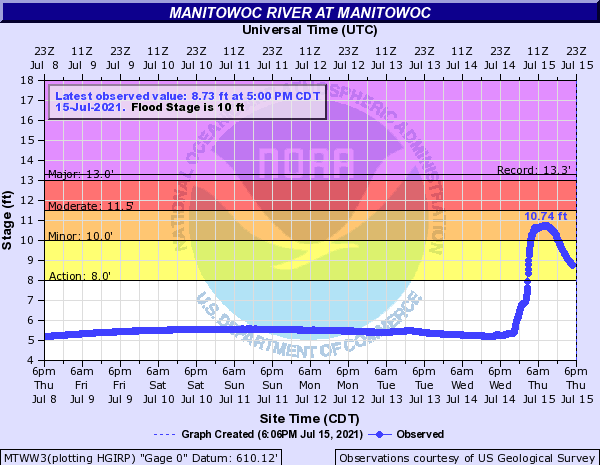
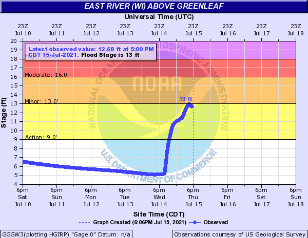
Rivers
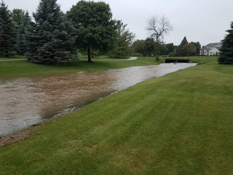
The heavy rainfall led to rapid rises in rivers across east central Wisconsin. However, only minor flooding was reported.
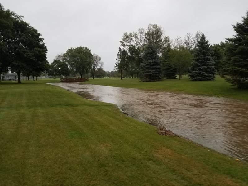
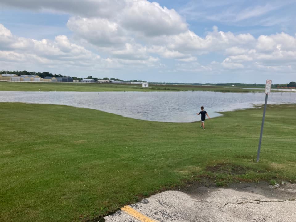
Photos
|
Manitowoc Airport (Photo credit: Tessa Maria) |
Manitowoc (Photo credit: Marina Koppa) |
Manitowoc (Photo credit: Marina Koppa) |
 |
 |
|
|
Calumet County (Photo credit: Calumet Co EM) |
Calumet County (Photo credit: Calumet Co EM) |
 |
Media use of NWS Web News Stories is encouraged! Please acknowledge the NWS as the source of any news information accessed from this site. |
|


.jpg)
.jpg)