Severe Thunderstorms in Central and East-Central Wisconsin - June 11, 2001
During the late evening of June 11, 2001, a large thunderstorm complex (which included a bow echo and subsequent "bookend vortex") moved across central and east-central Wisconsin. Winds exceeded 70 mph across the area, resulting in thousands of downed trees and damage to homes and businesses. What made the storm particularly significant was the sustained strong winds near the bookend vortex, causing more damage than typically experienced with a single severe wind gust. In Oshkosh, winds of 45 to 70+ mph were recorded from 919 pm until 1005 pm, veering from west to north during that span.
Warnings were issued, on average, 20 minutes before the storm hit the area. Forecasts issued by the NWS Green Bay office highlighted the risk for damaging winds as early as 4 a.m. that morning.
A map of preliminary storm reports is here.
Meteorological Overview
The initial thunderstorms developed across southern and central Minnesota during the mid-afternoon hours north of a warm front that extended east from a surface low over southwest Minnesota across southwest Wisconsin. Synoptic-scale lift and destabilization over the genesis region was provided by a shortwave trough moving across northern Minnesota, in concert with low-level convergence associated with a 30-35 kt 850 mb low-level jet over Iowa. The airmass south of the surface warm front over Iowa was very warm and moist with temperatures generally in the low to mid 90s and surface dew points in the lower 70s. Despite boundary layer CAPES of at least 3500 J/kg, the airmass south of the front over Iowa was strongly capped with 700 mb temperatures around +12 degrees C.
Farther north, thunderstorms were being fed by a steady supply of very unstable air transported northward across the warm front and ahead of the shortwave trough over central Minnesota, where steep mid-level lapse rates of around 8 degrees C/Km were observed. The mid-level instability was forecast to advect east into central and southern Wisconsin during the late evening. Deep layer shear was also in place over the mesoscale convective system (MCS) genesis region where winds were observed to veer from 240 at 30 knots at 850 mb, to about 270 at 65 knots at 500 mb over central and southern Minnesota. Indeed, the initial thunderstorms that developed over Minnesota during the mid- to late afternoon hours were supercellular, spawning several tornadoes. These storms were able to tap the vorticity-rich boundary layer just north of the surface warm front. The storms continued to move southeast, north of the surface warm front, into western and central Wisconsin by 00Z June 12 (7 pm CDT on June 11) and evolved into a large damaging wind-producing bow echo that raced across east central Wisconsin between 00Z and 05Z on June 12 (7 pm through midnight on June 11).
Radar Imagery - Reflectivity
Images are from the NWS Green Bay WSR-88D Doppler Radar. Click on small images for larger picture.
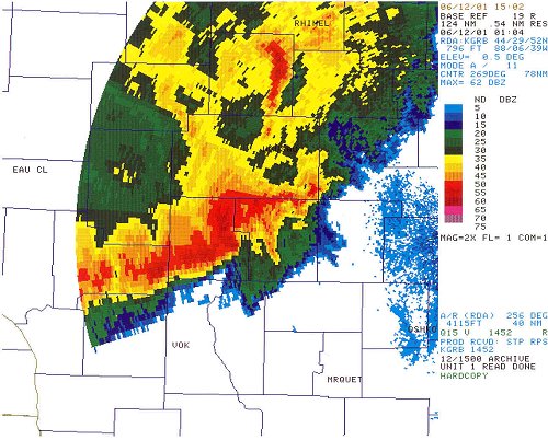 This image shows the developing bow echo as it roared through Wood county. The image (0.5 deg elevation) was taken at 804 pm CDT.
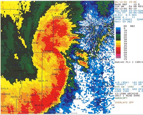 The bookend vortex has developed as the storm moves through southern Outagamie and Winnebago counties. The image (0.5 deg elevation) was taken at 919 pm CDT.
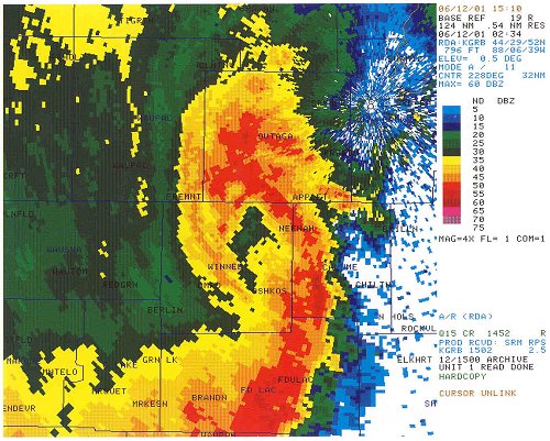 The vortex has an "eye" structure at this point. The image (0.5 deg elevation) was taken at 934 pm CDT.
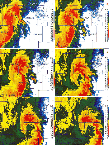 At left is a one hour radar animation (1.5 deg elevation), as seen from the NWS Green Bay Doppler radar. The loop begins at 9 pm (02Z) as the bookend vortex evolved. The city of Appleton is near the center of the screen; Oshkosh is 15 miles south.
Damage
Click on small images for larger picture.
 The severe winds on Lake Butte des Morts near Oshkosh pushed these boats into a pile. Many dozens of boats were damaged on area lakes by the pounding wind. (© Milwaukee Journal Sentinel, 2001; photographer Erwin Gebhard. Used with permission.)
 Besides uprooting and snapping trees, the wind tore sheets of metal off buildings in Appleton.