Overview
|
Multiple rounds of storms moved across the western Great Lakes on Tuesday, May 21st. During the morning and early afternoon hours, non-severe storms produced heavy rainfall and frequent lightning, along with brief gusty winds associated with a wake low. By mid-afternoon there was a lull in precipitation across much of the area, that helped the atmosphere recover and reenergize ahead of a fast-moving line of severe storms moving across Iowa and southwestern Wisconsin. A line of severe storms moved into central Wisconsin around 7pm. The storms produced widespread wind damage and a few tornadoes as they marched east/northeast across much of northeast Wisconsin. There were many reports of tree damage and power outages, with some structures damaged as well. This page will continue to be updated as we collect more information in the coming days.
Please click on the tabs below for more information. |
 |
A Favorable Environment for Severe Thunderstorms
|
The animation on the left (Figure 1) denotes an unseasonably strong 500 mb trough associated with unseasonably strong jet energy. Note the core of 70-80 kts winds (denoted by the "J") advancing north toward the western Great Lakes region during the afternoon of Tuesday May 21. This strong upper-level energy set the stage for a widespread severe weather outbreak. |
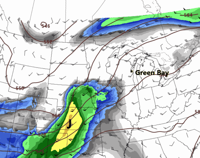 Figure 1 - HREF 500mb Mean Winds (shaded) and Heights (contours) |
|
The upper-level energy led to the formation of a seasonably strong surface low pressure system over the central Plains (Figure 2). The surface low (and associated cold front) deepened as it moved northeast to western Lake Superior by late Tuesday evening. |
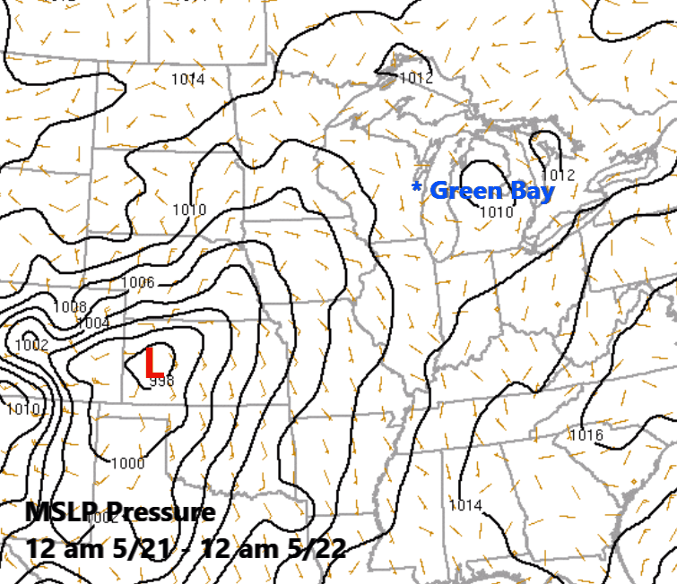 Figure 2 - RAP Mean Sea Level Pressure (MSLP). Surface low center denoted by the "L" in the animation. |
|
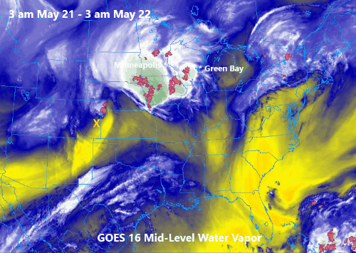
The GOES-16 mid-level water vapor animation (Figure 3) nicely depicts the evolution of the storm system over the central CONUS during the day on Tuesday. Note the vigorous short wave impulse (denoted by the "X") ejecting northeast out of the Central Plains toward the western Great Lakes followed by rapid development of deep convection just ahead of it over Iowa. Note how the convection quickly expands southward along the cold front sweeping across the Southern Plains. |
|
| As the surface low deepened and advanced northeast toward the western Great Lakes Tuesday afternoon, a very unstable airmass was quickly transported northward into the northern Mississippi Valley and upper Midwest by late afternoon (Figure 4). More importantly, the strong instability was collocated with very strong deep layer wind shear. This was especially the case over the state of Iowa. Note in Figure 4 that the greatest surface-based instability (> 3000 J/Kg) was co-located with very strong wind shear over southwest Iowa by early afternoon. This combination of strong shear and high instability lead to the rapid formation of deadly discrete tornadic supercells (Figure 5) over Iowa ahead of an advancing cold front. | 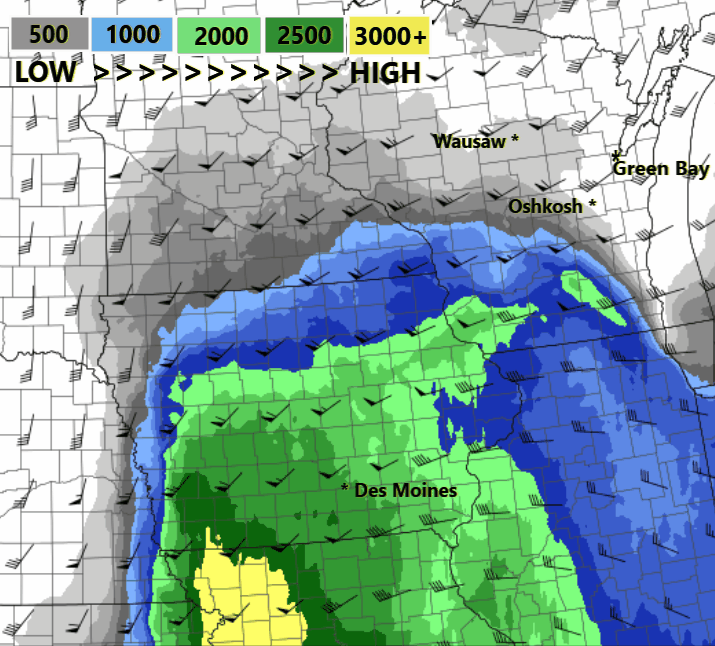 Figure 4 - HREF Mean Deep Layer Shear Vectors and Surface-Based Instability (shaded). |
| Also note in Figure 4 that the instablity was noticeably lower over central and northeast Wisconsin (500-750 J/kg) later in the day. However, given the strong upper-level jet energy, lift associated with the advancing cold front and strong deep layer shear that was spreading over the area, the available instability was more than adequate to generate a couple bands of quasilinear severe convection. | 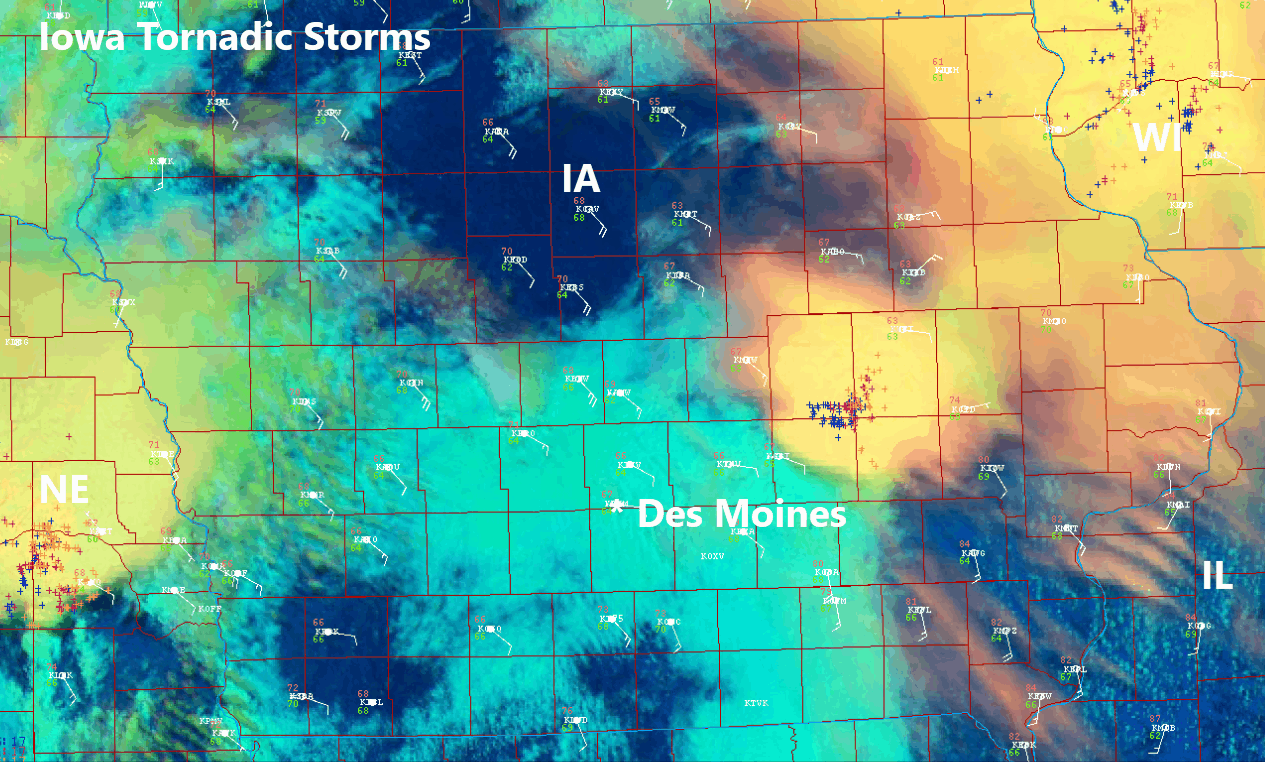 Figure 5 - GOES-16 Enhanced Visible Imagery (Day Cloud Phase Distinction) denoting rapid development of tornadic supercell storms over Iowa. GOES-16 lightning data is overlaid on the imagery. |
|
Figure 6 is another enhanced GOES-16 satellite animation showing the large bands of quasilinear severe convection as it was approaching central Wisconsin around 7 pm.
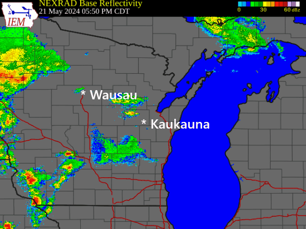
For more information on the radar evolution of these storms that produced widespread straight-line winds in addition to a few embedded tornadoes, refer to the "Tornado Listing" tab. |
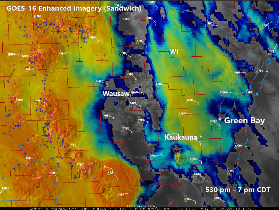 Figure 6 - GOES-16 Enhanced Imagery (Sandwich). |
Tornado Listing
|
Unity - Marathon County
Track Map 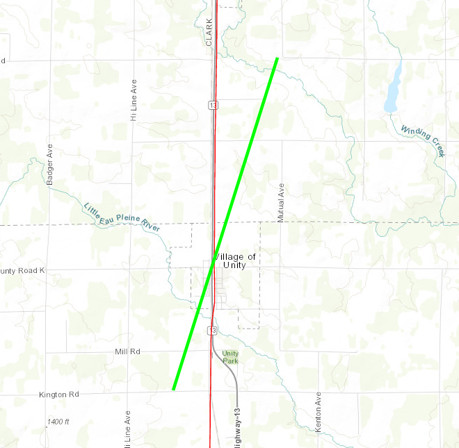 
|
|||||||||||||||||||
|
Fenwood - Marathon County
Track Map 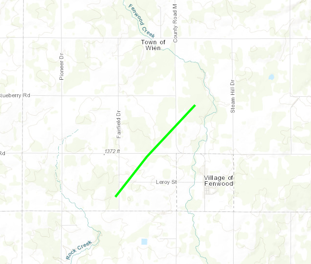
|
|||||||||||||||||||
|
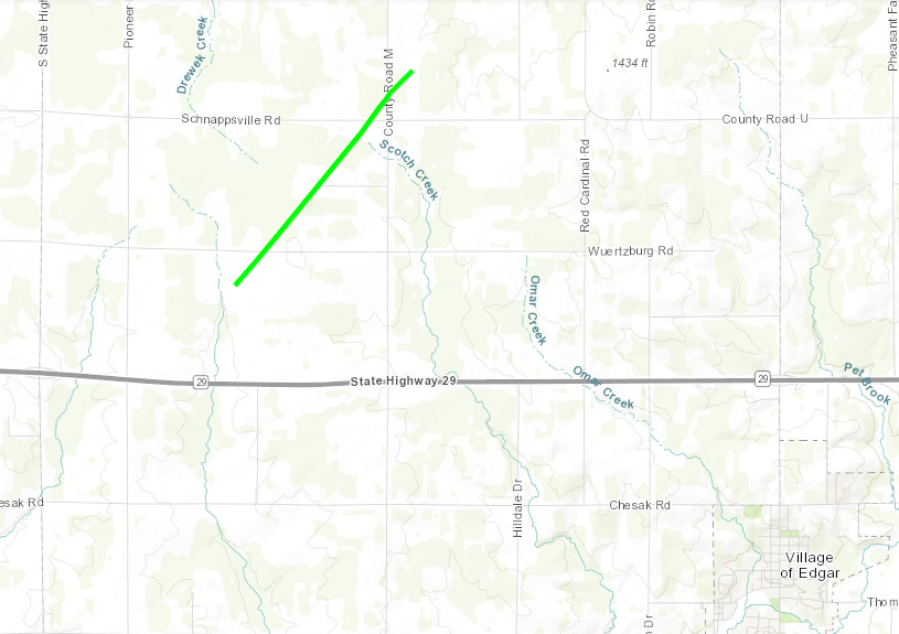
Edgar - Marathon County
Track Map
|
|||||||||||||||||||
|
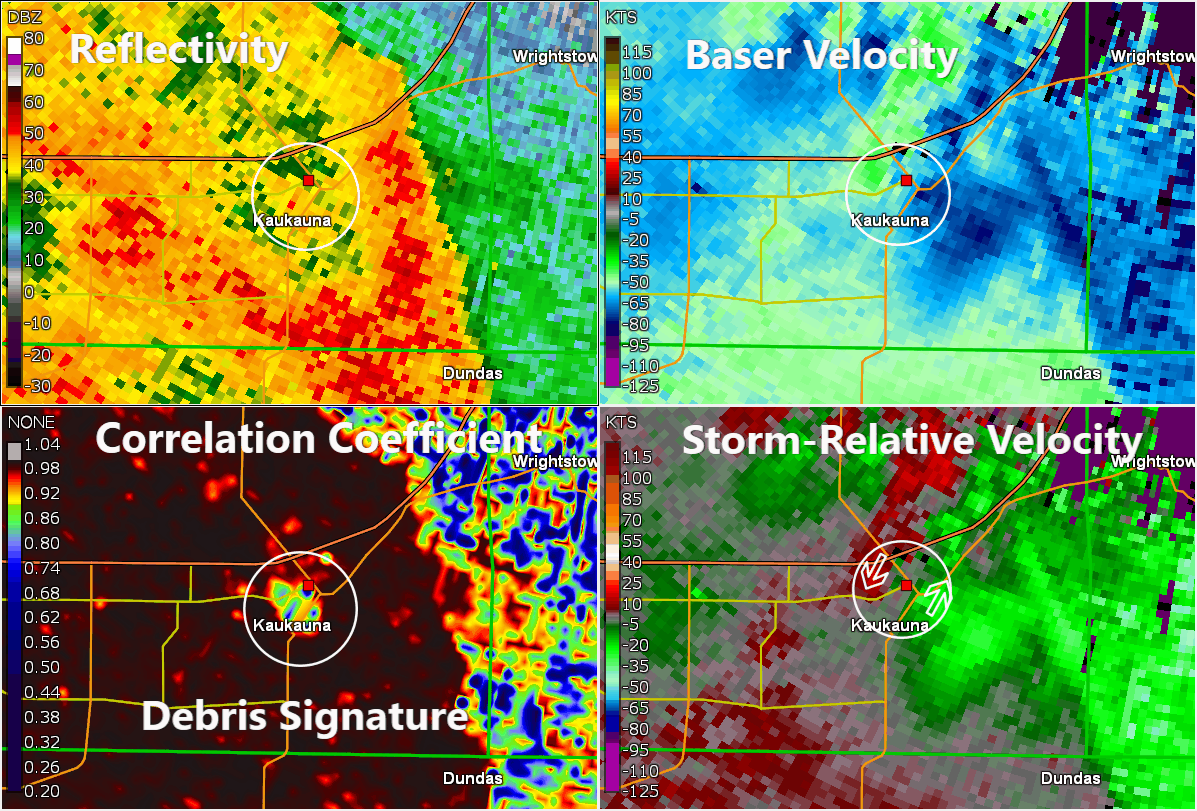
Kaukauna - Outagamie County
Track Map 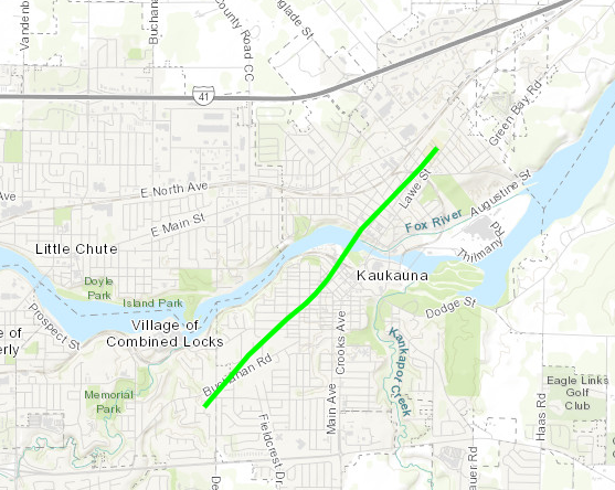
|
||||||||||||||||||
|
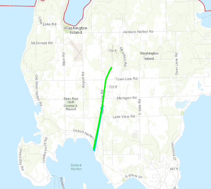
Washington Island - Door County
Track Map
|
||||||||||||||||||
| EF0 Weak 65-85 mph |
EF1 Moderate 86-110 mph |
EF2 Significant 111-135 mph |
EF3 Severe 136-165 mph |
EF4 Extreme 166-200 mph |
EF5 Catastrophic 200+ mph |
 |
|||||
Storm Reports
 |
|
| Storm Reports on May 21, 2024 |
PRELIMINARY LOCAL STORM REPORT...SUMMARY
NATIONAL WEATHER SERVICE GREEN BAY WI
157 AM CDT Wed May 22 2024
..TIME...   ...EVENT...      ...CITY LOCATION...     ...LAT.LON...
..DATE...   ....MAG....      ..COUNTY LOCATION..ST.. ...SOURCE....
            ..REMARKS..

0736 PM     Tornado          Unity                   44.85N 90.31W
05/21/2024                   Marathon           WI   NWS Storm Survey

            NWS survey team conducted damage survey on
            5/22/24 and confirmed an EF1 tornado that
            impacted Unity, Wisconsin along the Clark
            and Marathon county line. Wind speeds were
            estimated at 105 mph. Time estimated from
            radar when tornado crossed into Marathon
            County. More details to follow.

0737 PM     Tstm Wnd Gst     Marshfield Municipal Ai 44.64N 90.19W
05/21/2024  M70 MPH          Wood               WI   ASOS

0739 PM     Tstm Wnd Dmg     4 WNW Bakerville        44.66N 90.28W
05/21/2024                   Wood               WI   Trained Spotter

            Marshfield area. Trees down at Eagle Road
            and County H.

0739 PM     Tstm Wnd Dmg     3 NNW Bakerville        44.66N 90.23W
05/21/2024                   Wood               WI   Trained Spotter

            Trees down in Marshfield. Wren and Robin
            roads partially blocked.

0745 PM     Tstm Wnd Gst     2 SSW Stratford         44.76N 90.10W
05/21/2024  M58 MPH          Marathon           WI   Mesonet

            Measured at the Marshfield Wisconet station.

0747 PM     Tornado          2 W Fenwood             44.86N 90.05W
05/21/2024                   Marathon           WI   NWS Storm Survey

            NWS Green Bay Damage Survey, with
            coordination from Marathon County Emergency
            Management, found an EF-1 tornado that
            started at this location and went NE for
            2.11 miles. Estimated Peak Wind was 87 mph.
            Delayed Report.
0751 PM     Tornado          4 WSW Poniatowski       44.95N 90.05W
05/21/2024                   Marathon           WI   NWS Storm Survey

            NWS Green Bay Damage Survey, with
            coordination from Marathon County Emergency
            Management, found an EF-1 tornado that
            started at this location and went NE for
            2.13 miles. Estimated Peak Wind was 92 mph.
            Delayed Report.
0757 PM     Tstm Wnd Gst     Wisconsin Rapids Airpor 44.36N 89.84W
05/21/2024  M63 MPH          Wood               WI   ASOS

            Reported at KISW - Alexander Field South
            Wood County Airport.

0800 PM     Tstm Wnd Dmg     Stratford               44.79N 90.08W
05/21/2024                   Marathon           WI   Public

            Trees down.

0807 PM     Tstm Wnd Gst     Wausau Downtown Airport 44.93N 89.63W
05/21/2024  M60 MPH          Marathon           WI   Public

0809 PM     Tstm Wnd Dmg     5 SW Whiting            44.44N 89.65W
05/21/2024                   Portage            WI   Trained Spotter

            Street signs bent over at the intersection
            of highways 54 and F to west of Plover.

0814 PM     Tstm Wnd Dmg     Merrill                 45.18N 89.68W
05/21/2024                   Lincoln            WI   911 Call Center

            Multiple reports of trees and wires down
            across the Merrill area. Time based on
            radar.

0830 PM     Tstm Wnd Dmg     1 SE Harrison           45.47N 89.48W
05/21/2024                   Lincoln            WI   911 Call Center

            Trees and wires down near Harrison. Time
            based on radar.

0830 PM     Tstm Wnd Dmg     7 W Deerbrook           45.23N 89.31W
05/21/2024                   Langlade           WI   911 Call Center

            Trees down in Township of Vilas.

0848 PM     Tstm Wnd Dmg     3 W Monico              45.58N 89.17W
05/21/2024                   Oneida             WI   911 Call Center

            Trees down at the intersection of highways 8
            and 45 in the Town of Monico. Time estimated
            from radar.

0850 PM     Tstm Wnd Dmg     2 NE Medina             44.28N 88.59W
05/21/2024                   Outagamie          WI   Public

            Heavy downfall, severe bending of trees,
            winds of 60+ (estimated).

0850 PM     Tstm Wnd Dmg     Kaukauna                44.28N 88.27W
05/21/2024                   Outagamie          WI   Trained Spotter

            Spotter reported several trees down in the
            City of Kaukauna with lose of power. Spotter
            estimated wind gusts reached 70 mph as
            storms moved through.

0855 PM     Rain             2 SSW Plover            44.43N 89.55W
05/21/2024  M2.11 Inch       Portage            WI   Trained Spotter

0857 PM     Tornado          1 SE Kimberly           44.27N 88.29W
05/21/2024                   Outagamie          WI   NWS Storm Survey

            EF-1 Tornado confirmed in the Village of
            Kaukauna. 95 mph max wind speeds. 5/21/24
            857 pm to 901 pm. Separate damage surveys
            conducted by NWS employees on 5/21/24 and
            5/22/24. Scattered tree damage along path of
            tornado. Structure damage to outbuildings
            along Buchanan Road and an apartment
            building along Bicentennial Court.

0857 PM     Tstm Wnd Gst     Clintonville            44.62N 88.76W
05/21/2024  E70 MPH          Waupaca            WI   Trained Spotter

            Trained spotter reported estimated wind
            gusts of 70 mph as well as rainfall rates of
            over 1 inch per hour and frequent cloud to
            ground lightning.

0902 PM     Tstm Wnd Dmg     Kaukauna                44.26N 88.26W
05/21/2024                   Outagamie          WI   Emergency Mngr

            Trees and wires down in Kaukauna and Little
            Chute. Semi tipped over in Kaukauna. Time
            based on radar.

0906 PM     Tstm Wnd Dmg     2 E Park Ridge          44.52N 89.50W
05/21/2024                   Portage            WI   Trained Spotter

            Trained spotter reported trees down on Old
            Highway 18 east of Sevens Point. Road is
            impassable.

0917 PM     Tstm Wnd Gst     2 WNW Ashwaubenon       44.50N 88.11W
05/21/2024  M56 MPH          Brown              WI   NWS Employee

            At NWS Green Bay.

0920 PM     Tstm Wnd Dmg     1 N Ashwaubenon         44.50N 88.07W
05/21/2024                   Brown              WI   Law Enforcement

            Multiple reports of wires down. Report of
            tree through roof.

0924 PM     Tstm Wnd Gst     2 WNW Howard            44.57N 88.10W
05/21/2024  M68 MPH          Brown              WI   Public

            Delayed report.
0925 PM     Tstm Wnd Dmg     2 NNE Ashwaubenon       44.51N 88.06W
05/21/2024                   Brown              WI   Trained Spotter

            Large branches down and power out.
0941 PM     Tstm Wnd Dmg     2 SSW Howard            44.53N 88.08W
05/21/2024                   Brown              WI   Trained Spotter

            A lot of tree limbs down covering S Taylor
            Road in Green Bay.

0945 PM     Tstm Wnd Dmg     Green Bay               44.51N 88.01W
05/21/2024                   Brown              WI   Law Enforcement

            Multiple reports of trees and powerlines
            down across the City of Green Bay.

0953 PM     Tstm Wnd Gst     Marinette               45.10N 87.63W
05/21/2024  E70 MPH          Marinette          WI   Trained Spotter

            Trained spotter reported 70 mph winds as
            well as downed trees and lose of power.

0955 PM     Marine Tstm Wind 2 WSW Oconto            44.87N 87.92W
05/21/2024  M43 MPH          Oconto             WI   AWOS

            AWOS station KOCQ Oconto Airport.

0955 PM     Marine Tstm Wind 1 SSW Sturgeon Bay      44.83N 87.38W
05/21/2024  M44 MPH          Door               WI   ASOS

0958 PM     Tstm Wnd Dmg     Sturgeon Bay            44.83N 87.37W
05/21/2024                   Door               WI   Amateur Radio

            Tree down blocking road between Oregon St.
            and 7th Ave. Time based on radar.

1000 PM     Marine Tstm Wind 9 ENE Peshtigo          45.09N 87.59W
05/21/2024  M58 MPH          LMZ521             WI   C-Man Station

            Menominee marine observation. MNMM4.

1001 PM     Marine Tstm Wind 10 ENE Peshtigo         45.11N 87.56W
05/21/2024  M45 MPH          LMZ521             WI   ASOS

1003 PM     Rain             6 E Knowlton            44.69N 89.55W
05/21/2024  M2.20 Inch       Marathon           WI   Public

            Total since this morning.

1005 PM     Tstm Wnd Dmg     2 W Egg Harbor          45.04N 87.31W
05/21/2024                   Door               WI   Amateur Radio

            Tree down blocking Bay Shore Drive near
            Horseshoe Bay. Time estimated based on
            radar.

1008 PM     Tstm Wnd Dmg     3 S Institute           44.85N 87.30W
05/21/2024                   Door               WI   911 Call Center

            Tree down in Sevastopol.

1010 PM     Tstm Wnd Dmg     Egg Harbor              45.04N 87.28W
05/21/2024                   Door               WI   911 Call Center

            Trees and wires down.

1011 PM     Tstm Wnd Dmg     Fish Creek              45.13N 87.23W
05/21/2024                   Door               WI   911 Call Center

            Trees down.

1035 PM     Tstm Wnd Dmg     2 SSW Washington Island 45.36N 86.92W
05/21/2024                   Door               WI   Amateur Radio

            Trees down with home damage. Multiple
            additional trees with roads blocked in the
            area.

1032 PM     Tornado          2 SSW Washington Island 45.35N 86.91W
05/21/2024                   Door               WI   NWS Storm Survey

            NWS Green Bay Damage Survey, with
            coordination from Door County Emergency
            Management, found an EF-1 tornado that
            started at this location and went NE for
            2.28 miles. Estimated Peak Wind was 90 mph.
            Delayed Report.
1035 PM     Tstm Wnd Dmg     2 SW Washington Island  45.36N 86.93W
05/21/2024                   Door               WI   Amateur Radio

            Multiple trees and wires down across
            Washington Island. Officials are starting to
            clear roads.
Rainfall
Public Information Statement
National Weather Service Green Bay WI
1028 AM CDT Wed May 22 2024

...24 HR PRECIPITATION REPORTS...

Location                     Amount    Time/Date       Lat/Lon/Elev (ft.)

...Wisconsin...

...Brown County...
Denmark WWTP                 1.41 in   0800 AM 05/22   44.35N/87.81W/819
Denmark                      1.16 in   0950 AM 05/22   44.39N/87.86W/859
Denmark 1 NNE                1.03 in   0950 AM 05/22   44.35N/87.83W/866
Green Bay 2.9 SSE            0.93 in   0700 AM 05/22   44.48N/87.96W/659
Wrightstown                  0.88 in   0945 AM 05/22   44.33N/88.17W/652
Wrightstown 0.4 ENE          0.84 in   0700 AM 05/22   44.33N/88.17W/652
De Pere 2.0 ESE              0.80 in   0800 AM 05/22   44.43N/88.03W/601
De Pere                      0.77 in   0945 AM 05/22   44.37N/88.07W/721
Green Bay                    0.75 in   0945 AM 05/22   44.51N/88.01W/594
De Pere 2.1 E                0.66 in   0700 AM 05/22   44.44N/88.03W
Green Bay 1 ESE              0.64 in   0945 AM 05/22   44.50N/87.98W/597
NWS Green Bay                0.64 in   0700 AM 05/22   44.50N/88.11W/676
Champion 1 NNW               0.61 in   0700 AM 05/22   44.61N/87.81W/758
Green Bay 4.4 SSW            0.60 in   0700 AM 05/22   44.46N/88.02W/609
Suamico 4.4 WNW              0.55 in   0730 AM 05/22   44.66N/88.12W/691
Green Bay Botanical Garden   0.54 in   0700 AM 05/22   44.53N/88.10W/890
De Pere                      0.43 in   0950 AM 05/22   44.44N/88.05W/643
Green Bay 7.1 WNW            0.42 in   0700 AM 05/22   44.57N/88.12W/702
Howard 1.7 SSW               0.42 in   0700 AM 05/22   44.55N/88.09W
Green Bay Airport            0.42 in   0916 AM 05/22   44.48N/88.13W/686

...Calumet County...
Chilton 1 W                  1.87 in   0949 AM 05/22   44.03N/88.17W/876
Chilton 0.5 E                1.80 in   0700 AM 05/22   44.03N/88.15W/840
Hilbert 5.9 WSW              1.45 in   0451 AM 05/22   44.11N/88.27W/941
Brillion 4.9 S               1.34 in   0700 AM 05/22   44.11N/88.05W/831
Brillion                     1.30 in   0923 AM 05/22   44.18N/88.07W/810
New Holstein 1 W             0.93 in   0950 AM 05/22   43.95N/88.10W/994
Forest Junction              0.90 in   0950 AM 05/22   44.21N/88.21W/833
Darboy 3 SE                  0.86 in   0700 AM 05/22   44.20N/88.33W/791
Menasha 2.4 E                0.69 in   0700 AM 05/22   44.21N/88.39W/797
Menasha 2.7 ENE              0.62 in   0550 AM 05/22   44.22N/88.38W/799

...Door County...
Forestville 4 E              0.89 in   0700 AM 05/22   44.70N/87.40W/694
Potawatomi State Park 3 SE   0.84 in   0945 AM 05/22   44.83N/87.40W/696
Sturgeon Bay Exp Farm        0.72 in   0730 AM 05/22   44.87N/87.33W/660
Egg Harbor 3.7 SSE           0.68 in   0800 AM 05/22   45.00N/87.26W
Fish Creek 1 E WWTP          0.62 in   0430 AM 05/22   45.12N/87.23W/646
Washington Island 1 WSW      0.61 in   0950 AM 05/22   45.36N/86.93W/588
Egg Harbor 4.6 SW            0.58 in   0700 AM 05/22   44.99N/87.35W/763
Baileys Harbor 4.3 N         0.58 in   0800 AM 05/22   45.13N/87.14W
Potawatomi State Park 4 ESE  0.56 in   0949 AM 05/22   44.83N/87.36W/643
Baileys Harbor 3.4 NE        0.56 in   0440 AM 05/22   45.10N/87.08W/639
Ephraim 1 NE - WWTP          0.51 in   0840 AM 05/22   45.17N/87.15W/728
Sister Bay 1 N               0.46 in   0600 AM 05/22   45.20N/87.11W/700
Ellison Bay 3.6 NE           0.43 in   0630 AM 05/22   45.29N/87.02W/594
Ephraim Airport              0.39 in   0935 AM 05/22   45.13N/87.18W/747
Carlsville 1.9 NW            0.37 in   0630 AM 05/22   44.97N/87.36W/768

...Florence County...
Florence                     1.83 in   0700 AM 05/22   45.93N/88.26W/1305
Spread Eagle 1 NW            1.65 in   0700 AM 05/22   45.89N/88.14W/1216
Praws 8                      1.44 in   0935 AM 05/22   45.76N/88.60W/1539

...Forest County...
Wabeno 2 NNW                 1.83 in   0930 AM 05/22   45.46N/88.68W/1560
Argonne 1.5 NW               1.61 in   0711 AM 05/22   45.67N/88.90W/1673
Crandon                      1.52 in   0950 AM 05/22   45.52N/88.85W/1650

...Kewaunee County...
Kewaunee                     1.10 in   0645 AM 05/22   44.46N/87.50W/592
Luxemburg 0.9 S              1.02 in   0538 AM 05/22   44.53N/87.71W
Luxemburg 5.9 S              1.00 in   0700 AM 05/22   44.46N/87.72W
Casco 0.4 NNW                0.88 in   0516 AM 05/22   44.56N/87.62W/749
Dyckesville 2 SSE            0.76 in   0716 AM 05/22   44.61N/87.74W
Rankin 2 E                   0.75 in   0950 AM 05/22   44.60N/87.44W/604

...Langlade County...
White Lake 1.4 SE            1.96 in   0800 AM 05/22   45.15N/88.74W/1289
Antigo 1 SSW                 1.93 in   0800 AM 05/22   45.13N/89.15W/1450
Antigo 2 ENE                 1.90 in   0905 AM 05/22   45.16N/89.11W/1499
Antigo Airport               1.52 in   0935 AM 05/22   45.15N/89.12W/1518
Elcho 4.8 SW                 1.31 in   0700 AM 05/22   45.38N/89.25W/1737

...Lincoln County...
Tomahawk 1.2 SSW             1.59 in   0600 AM 05/22   45.46N/89.73W/1451
Merrill 0.9 E                1.23 in   0800 AM 05/22   45.18N/89.66W/1250
Merrill                      1.21 in   0945 AM 05/22   45.18N/89.75W/1289
Merrill Airport              1.05 in   0935 AM 05/22   45.20N/89.72W/1310
Merrill 8 W                  1.00 in   0600 AM 05/22   45.18N/89.85W/1419
Merrill 14.1 W               0.92 in   0700 AM 05/22   45.15N/89.99W
Tomahawk Airport             0.80 in   0935 AM 05/22   45.47N/89.82W/1465
Bradley 0.7 N                0.70 in   0700 AM 05/22   45.54N/89.75W/1460
Spirit Falls 2.7 NE          0.21 in   0830 AM 05/22   45.48N/89.95W/1509

...Manitowoc County...
Brillion 2 SSE               1.23 in   0800 AM 05/22   44.14N/88.04W/858
Valders 3.3 WSW              1.09 in   0700 AM 05/22   44.04N/87.94W/814
St. Nazianz 2 W              1.07 in   0700 AM 05/22   44.00N/87.96W/853
Manitowoc                    1.04 in   0942 AM 05/22   44.12N/87.64W/597
Two Rivers                   0.95 in   0948 AM 05/22   44.15N/87.56W/6
Mishicot 0.1 NNW             0.88 in   0800 AM 05/22   44.23N/87.64W/657
Two Rivers 0.7 NE            0.87 in   0900 AM 05/22   44.16N/87.57W/592
Two Rivers 4.1 WNW           0.86 in   0645 AM 05/22   44.19N/87.65W/647
Manitowoc Airport            0.81 in   0856 AM 05/22   44.12N/87.67W/618
Two Rivers 2 NW              0.81 in   0700 AM 05/22   44.18N/87.58W
Manitowoc 4.1 SW             0.81 in   0630 AM 05/22   44.06N/87.74W/775
Manitowoc 1.4 NW             0.75 in   0700 AM 05/22   44.11N/87.69W/657
Two Rivers 1.2 N             0.75 in   0700 AM 05/22   44.17N/87.58W/607
Millhome 2 E                 0.73 in   0703 AM 05/22   43.90N/87.91W/900
Manitowoc 5.1 SW             0.71 in   0800 AM 05/22   44.06N/87.76W/788
Reedsville                   0.53 in   0945 AM 05/22   44.23N/87.96W/869

...Marathon County...
Knowlton 1 NW                2.35 in   0700 AM 05/22   44.73N/89.70W
Evergreen 1 E                2.29 in   0800 AM 05/22   44.84N/89.60W/1197
Weston 1 NE                  2.15 in   0700 AM 05/22   44.92N/89.54W/1216
Mosinee 3.6 NE               2.14 in   0700 AM 05/22   44.82N/89.63W/1286
Mosinee 2.0 W                1.90 in   0700 AM 05/22   44.79N/89.72W/1147
Rothschild 0.5 ENE           1.88 in   0700 AM 05/22   44.89N/89.61W
Mosinee                      1.83 in   0945 AM 05/22   44.86N/89.68W/1167
Wausau Airport               1.81 in   0922 AM 05/22   44.93N/89.62W/1208
Moon 6 SW                    1.77 in   0905 AM 05/22   44.70N/89.87W/1149
Wausau                       1.76 in   0945 AM 05/22   44.95N/89.61W/1558
Wausau 5.4 SSW               1.76 in   0700 AM 05/22   44.89N/89.69W/1213
Evergreen 1.5 WSW            1.51 in   0650 AM 05/22   44.84N/89.67W/1174
Wausau 2.4 W                 1.44 in   0630 AM 05/22   44.96N/89.69W
Brokaw 1 W                   1.33 in   0945 AM 05/22   45.03N/89.69W/1364
Spencer - Wwtp               1.25 in   0730 AM 05/22   44.75N/90.29W/1296
Athens 0.6 SSW               1.10 in   0700 AM 05/22   45.03N/90.08W
Spencer 3 E                  0.79 in   0945 AM 05/22   44.77N/90.21W/1288
Stratford 4 W                0.52 in   0945 AM 05/22   44.81N/90.17W/1312

...Marinette County...
Crivitz 12.5 WNW             2.03 in   0702 AM 05/22   45.28N/88.26W/896
Amberg 9 E                   1.81 in   0612 AM 05/22   45.48N/87.81W/728
Wausaukee 1.6 NW             1.81 in   0750 AM 05/22   45.38N/87.96W/745
Niagara 5.1 SE               1.76 in   0700 AM 05/22   45.74N/87.92W/1025
Wausaukee 2 NW               1.65 in   0905 AM 05/22   45.39N/87.97W/763
Marinette - Wps              1.61 in   0556 AM 05/22   45.24N/88.01W/680
Crivitz 1 ESE                1.22 in   0950 AM 05/22   45.23N/88.00W/896
Menominee 1.6 S              1.00 in   0730 AM 05/22   45.10N/87.62W/592
Peshtigo 1 S                 0.85 in   0730 AM 05/22   45.03N/87.74W/603
Peshtigo 1 N                 0.81 in   0950 AM 05/22   45.06N/87.75W/607
Athelstane 2 SW              0.46 in   0950 AM 05/22   45.40N/88.12W/959

...Menominee County...
Keshena 2 WNW                1.45 in   0931 AM 05/22   44.89N/88.66W/871

...Oconto County...
Mountain                     1.82 in   0949 AM 05/22   45.17N/88.44W/928
Townsend 5.0 WSW             1.80 in   0800 AM 05/22   45.29N/88.68W/1389
Shawano Lake 6 NNE           1.77 in   0800 AM 05/22   44.89N/88.48W
Townsend 1.7 NNW             1.72 in   0600 AM 05/22   45.35N/88.61W/1352
Breed 5 NE                   1.71 in   0930 AM 05/22   45.12N/88.37W/910
Lakewood                     1.66 in   0930 AM 05/22   45.31N/88.47W/1220
Suring 2.0 WNW               1.45 in   0700 AM 05/22   45.01N/88.41W/908
Abrams 1.4 N                 0.85 in   0600 AM 05/22   44.80N/88.06W
Little Suamico 1.8 SSW       0.45 in   0700 AM 05/22   44.68N/88.08W/675
Pulaski 6.6 E                0.42 in   0700 AM 05/22   44.68N/88.10W

...Oneida County...
Lac Du Flambeau 8.0 SSW      1.43 in   0805 AM 05/22   45.87N/89.99W
Rhinelander                  1.28 in   1030 PM 05/21   45.62N/89.41W/1611
Minocqua                     1.24 in   0630 AM 05/22   45.89N/89.73W/1601
Rhinelander 2 SW             1.16 in   0730 AM 05/22   45.60N/89.45W/1571
Willow                       1.16 in   0700 AM 05/22   45.70N/89.83W/1511
Rhinelander 5 N              1.16 in   0615 AM 05/22   45.71N/89.42W/1654
Rhinelander 5.5 NW           1.14 in   0645 AM 05/22   45.70N/89.48W
Arbor Vitae - Woodruff 2 S   1.09 in   0910 AM 05/22   45.89N/89.65W/1619
Rhinelander Airport          1.06 in   0949 AM 05/22   45.63N/89.48W/1599
Tomahawk 3 W                 0.96 in   0910 AM 05/22   45.59N/89.72W/1535

...Outagamie County...
New London 4.1 N             1.24 in   0600 AM 05/22   44.45N/88.73W/791
New London 3.3 NE            1.08 in   0716 AM 05/22   44.43N/88.70W/818
Black Creek 3 NW             0.83 in   0700 AM 05/22   44.50N/88.47W/785
Black Creek 5.6 WNW          0.73 in   0633 AM 05/22   44.52N/88.55W/786
Appleton 3.0 ESE             0.73 in   0620 AM 05/22   44.25N/88.34W
Shiocton 0.6 NW              0.72 in   0730 AM 05/22   44.44N/88.58W/755
Appleton WHBY Radio          0.63 in   0800 AM 05/22   44.25N/88.36W/750
Grand Chute                  0.60 in   0948 AM 05/22   44.31N/88.42W/801
Appleton                     0.54 in   0907 AM 05/22   44.29N/88.46W/830
Seymour                      0.52 in   0950 AM 05/22   44.54N/88.25W/830
Appleton 0.9 W               0.52 in   0700 AM 05/22   44.27N/88.42W/795
Appleton 1.3 NW              0.51 in   0700 AM 05/22   44.28N/88.41W/809
Appleton 2.3 NW              0.51 in   0300 AM 05/22   44.29N/88.43W/821
Mackville 2 S                0.50 in   0530 AM 05/22   44.31N/88.41W/835
Appleton 2.5 NW              0.42 in   0800 AM 05/22   44.30N/88.43W/837

...Portage County...
Stevens Point                2.59 in   0730 AM 05/22   44.51N/89.59W/1081
Plover 1.8 W                 2.56 in   0700 AM 05/22   44.46N/89.58W/1079
Rudolph 1 NNE                2.56 in   0600 AM 05/22   44.53N/89.79W/1137
Plover 1.4 S                 2.30 in   0700 AM 05/22   44.44N/89.55W/1084
Rosholt                      2.27 in   0709 AM 05/22   44.63N/89.31W/1141
Wisconsin Rapids 9.8 SE      2.11 in   0700 AM 05/22   44.28N/89.71W/1047
Plover                       1.92 in   0947 AM 05/22   44.44N/89.55W/1082
Wisconsin Rapids 6.6 ESE     1.87 in   0700 AM 05/22   44.35N/89.72W
Amherst 3 SE                 1.78 in   0700 AM 05/22   44.41N/89.26W/1041
Amherst 2.6 SSE              1.78 in   0700 AM 05/22   44.41N/89.26W
Stevens Point Airport        1.74 in   0935 AM 05/22   44.55N/89.53W/1106
Almond 5 NE                  1.56 in   0800 AM 05/22   44.31N/89.35W/1174
Amherst 1.5 N                1.44 in   0700 AM 05/22   44.47N/89.28W

...Shawano County...
Stockbridge-Munsee Reservati 1.65 in   0730 AM 05/22   44.87N/88.90W/1050
Split Rock 1 NNW             1.59 in   0800 AM 05/22   44.72N/89.02W/1025
Pella 3 SE                   1.53 in   0530 AM 05/22   44.74N/88.74W/869
Praws 7                      1.47 in   0935 AM 05/22   44.85N/88.63W/857
Shawano 2 SSW                1.36 in   0800 AM 05/22   44.76N/88.62W/809
Shawano 5.3 WNW              1.27 in   0652 AM 05/22   44.80N/88.69W
Shawano 1.6 NW               1.14 in   0700 AM 05/22   44.79N/88.62W/822
Pulaski 3.7 W                0.81 in   0700 AM 05/22   44.67N/88.31W/912
Shawano Airport              0.78 in   0935 AM 05/22   44.78N/88.57W/814

...Vilas County...
Manitowish Waters 0.6 S      1.70 in   0700 AM 05/22   46.12N/89.88W/1612
Phelps 2 SW                  1.30 in   0931 AM 05/22   46.04N/89.10W/1770
Boulder Junction 9 ENE       1.14 in   0700 AM 05/22   46.19N/89.46W/1714
Arbor Vitae-Johnson Lake     1.12 in   0612 AM 05/22   45.90N/89.73W/1601
Eagle River Airport          1.12 in   0935 AM 05/22   45.93N/89.27W/1641
Woodruff 2.5 NE              1.12 in   0700 AM 05/22   45.92N/89.66W/1662
Boulder Junction 1.4 NE      1.09 in   0700 AM 05/22   46.13N/89.62W/1663
Phelps 4.2 N                 1.07 in   0818 AM 05/22   46.12N/89.08W/1760
St Germain 0.6 NW            1.03 in   0700 AM 05/22   45.92N/89.49W/1643
Conover 4.8 WNW              1.01 in   0730 AM 05/22   46.09N/89.35W
Land O Lakes Airport         0.97 in   0935 AM 05/22   46.15N/89.22W/1694
Manitowish Waters Airport    0.93 in   0935 AM 05/22   46.12N/89.88W/1606
Arbor Vitae Airport          0.92 in   0935 AM 05/22   45.93N/89.73W/1620

...Waupaca County...
Ogdensburg 2 E               2.04 in   0700 AM 05/22   44.46N/88.98W/922
Manawa 3.6 SSW               1.65 in   0708 AM 05/22   44.41N/88.95W/895
Clintonville 0.9 N           1.48 in   0600 AM 05/22   44.62N/88.75W/802
Clintonville Airport         1.46 in   0935 AM 05/22   44.62N/88.73W/816
Iola 0.4 SSW                 1.46 in   0500 AM 05/22   44.50N/89.13W
Waupaca Airport              1.33 in   0935 AM 05/22   44.33N/89.02W/809
New London - WWTP            1.27 in   0700 AM 05/22   44.39N/88.75W/753
Waupaca 7.6 SW               1.27 in   0700 AM 05/22   44.27N/89.17W/906
Fremont                      1.26 in   0945 AM 05/22   44.28N/88.82W/748
Clintonville 0.7 WNW         1.19 in   0700 AM 05/22   44.63N/88.76W
Waupaca                      1.11 in   0937 AM 05/22   44.34N/89.11W/889

...Waushara County...
Wild Rose 2.6 ENE            1.28 in   0700 AM 05/22   44.19N/89.20W/920
Wild Rose 0.5 E              1.10 in   0500 AM 05/22   44.18N/89.24W/941
Wautoma 1 WSW                1.07 in   0912 AM 05/22   44.06N/89.29W/856
Wautoma 2 WNW                0.95 in   0950 AM 05/22   44.07N/89.31W/889
Wautoma Airport              0.93 in   0856 AM 05/22   44.03N/89.30W/855
Berlin WWTP                  0.90 in   0700 AM 05/22   43.99N/88.94W/768

...Winnebago County...
Menasha 1.5 W                1.18 in   0900 AM 05/22   44.20N/88.47W/754
Oshkosh 0.8 NW               1.17 in   0700 AM 05/22   44.02N/88.57W/758
Oshkosh                      1.16 in   0945 AM 05/22   44.01N/88.55W/757
Oshkosh Airport              1.15 in   0927 AM 05/22   43.97N/88.55W/794
Oshkosh 1.6 ESE              1.03 in   0700 AM 05/22   44.01N/88.52W/748
Oshkosh 2.0 W                0.90 in   0700 AM 05/22   44.02N/88.59W/778
Zittau                       0.87 in   0600 AM 05/22   44.22N/88.78W/795
Oshkosh 3.6 N                0.85 in   0600 AM 05/22   44.07N/88.55W
Omro 0.5 SSE                 0.74 in   0600 AM 05/22   44.03N/88.74W/784
Omro                         0.73 in   0906 AM 05/22   44.07N/88.69W/748
Neenah 1.1 ENE               0.71 in   0700 AM 05/22   44.17N/88.45W/770
Menasha 0.3 W                0.67 in   0700 AM 05/22   44.21N/88.44W/768
Omro 1 WSW                   0.67 in   0700 AM 05/22   44.02N/88.78W/752

...Wood County...
Rudolph 2.1 W                3.00 in   0700 AM 05/22   44.50N/89.84W/1120
Vesper                       2.85 in   0947 AM 05/22   44.47N/89.95W/1013
Port Edwards 2 E             2.59 in   0640 AM 05/22   44.34N/89.78W/1020
New Rome 3 WNW               2.48 in   0700 AM 05/22   44.26N/89.94W/979
Kellner 3 WNW                2.48 in   0700 AM 05/22   44.36N/89.77W/1029
Pittsville - WWTP            2.42 in   0700 AM 05/22   44.44N/90.13W/1016
Wisconsin Rapids 0.8 SSE     2.37 in   0800 AM 05/22   44.38N/89.83W/1014
Wisconsin Rapids 0.8 W       2.35 in   0745 AM 05/22   44.39N/89.85W/1021
Rudolph 1.8 ENE              2.32 in   0700 AM 05/22   44.51N/89.77W/1120
New Rome 1 WNW               2.04 in   0700 AM 05/22   44.25N/89.91W
Wisconsin Rapids Airport     2.00 in   0854 AM 05/22   44.37N/89.83W/1020
New Rome 4 ENE               1.95 in   0905 AM 05/22   44.26N/89.81W/873
Marshfield 6.5 S             1.70 in   0745 AM 05/22   44.57N/90.18W
Port Edwards 1 SE            1.66 in   0700 AM 05/22   44.34N/89.84W/971
Rudolph                      1.58 in   0950 AM 05/22   44.50N/89.79W/1028
Marshfield 5.6 SSW           1.57 in   0700 AM 05/22   44.59N/90.20W/1230
Hewitt 0.8 N                 1.40 in   0630 AM 05/22   44.64N/90.13W/1237
Marshfield 1.8 NE            1.27 in   0700 AM 05/22   44.68N/90.15W
Marshfield Airport           1.09 in   0920 AM 05/22   44.63N/90.18W/1241

Observations are collected from a variety of sources with varying
equipment and exposures. We thank all volunteer weather observers
for their dedication. Not all data listed are considered official.
Photos
City Name (County or Credit) |
City Name (County or Credit) |
City Name (County or Credit) |
City Name (County or Credit) |
 |
Media use of NWS Web News Stories is encouraged! Please acknowledge the NWS as the source of any news information accessed from this site. |
|