Overview
|
A strong area of low pressure lifted northeast across the Great Lakes, bringing a swath of heavy snow to eastern Wisconsin on Saturday, March 25, 2023. Initially, the surface low was forecast to track northeast across southern Illinois and central Indiana, with a west to east area of banded snowfall. However, as the event unfolded, the surface low tracked further northwest across northeast Illinois and northwest Indiana. This allowed the banded area of heavy snow to shift to the west, by about 30-60 miles, and become oriented more south to north, centered over the Fox Valley. The snow piled up quickly (2-4" per hour!) due to impressive snowfall rates on Saturday morning, leading to difficult travel, and a few isolated power outages. Both Green Bay and Appleton saw record snowfall during this event. Please see the tabs below for more information. |
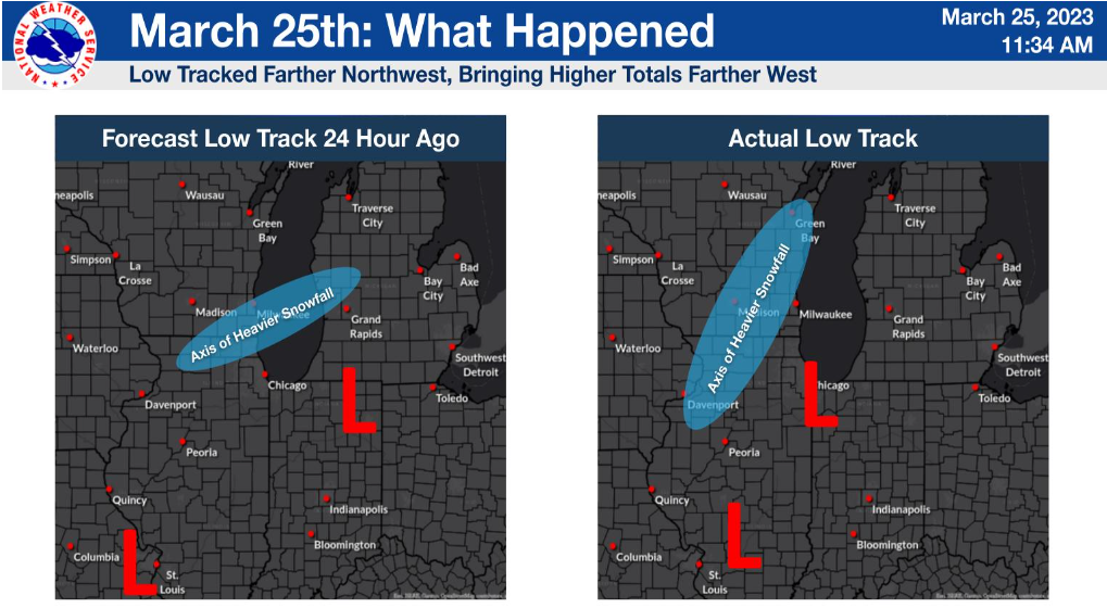 How the storm track and axis of heavier snow shifted west |
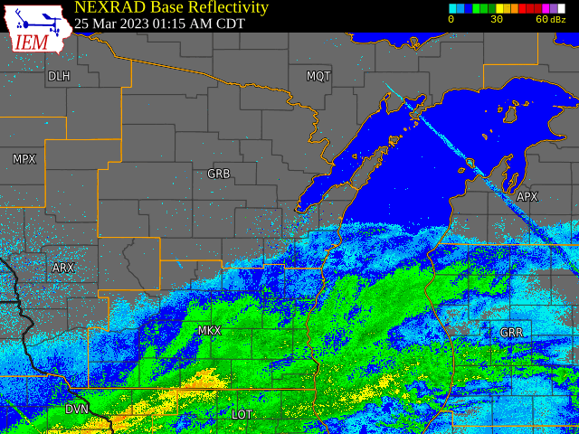 Radar Loop |
 GOES AirMass Composite Satellite |
|
|
Snow Reports
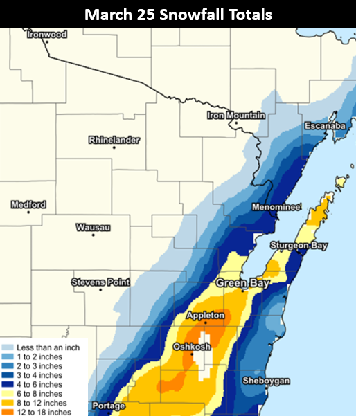 |
Due to the nature of this type of banded snowfall (frontogenetic) and how quickly the snow fell, snow reports varied significantly within the swath of snow, and even from one side of a town to another. Other factors, such as when the observation was taken, drifting, and compaction, also contributed to the large variations in measurements.
(Note: The map shows an estimate of snowfall.) |
PRELIMINARY LOCAL STORM REPORT...SUMMARY
NATIONAL WEATHER SERVICE GREEN BAY WI
923 PM CDT SAT MAR 25 2023

..TIME...   ...EVENT...      ...CITY LOCATION...     ...LAT.LON...
..DATE...   ....MAG....      ..COUNTY LOCATION..ST.. ...SOURCE....
            ..REMARKS..

0702 PM     SNOW             BRILLION                44.18N 88.06W
03/25/2023  M4.0 INCH        CALUMET            WI   PUBLIC


0623 PM     SNOW             ABRAMS                  44.78N 88.06W
03/25/2023  M5.3 INCH        OCONTO             WI   PUBLIC


0611 PM     HEAVY SNOW       4 N BELLEVUE            44.48N 87.91W
03/25/2023  M13.0 INCH       BROWN              WI   PUBLIC


0603 PM     HEAVY SNOW       1 SE APPLETON           44.25N 88.39W
03/25/2023  M15.0 INCH       OUTAGAMIE          WI   PUBLIC


0525 PM     HEAVY SNOW       LITTLE CHUTE            44.28N 88.26W
03/25/2023  M16.5 INCH       OUTAGAMIE          WI   PUBLIC


0504 PM     HEAVY SNOW       1 NNW SISTER BAY        45.19N 87.12W
03/25/2023  M10.0 INCH       DOOR               WI   PUBLIC


0500 PM     HEAVY SNOW       1 NNE OSHKOSH           44.03N 88.54W
03/25/2023  M16.0 INCH       WINNEBAGO          WI   PUBLIC


0456 PM     HEAVY SNOW       2 WSW KIMBERLY          44.27N 88.35W
03/25/2023  E21.5 INCH       OUTAGAMIE          WI   PUBLIC


0455 PM     SNOW             MOUNT MORRIS            44.11N 89.19W
03/25/2023  M1.0 INCH        WAUSHARA           WI   PUBLIC


0446 PM     HEAVY SNOW       1 NE DARBOY             44.24N 88.36W
03/25/2023  M16.0 INCH       OUTAGAMIE          WI   PUBLIC


0432 PM     SNOW             2 NW MANITOWOC          44.09N 87.69W
03/25/2023  M2.5 INCH        MANITOWOC          WI   PUBLIC


0425 PM     HEAVY SNOW       1 N APPLETON            44.27N 88.40W
03/25/2023  M11.5 INCH       OUTAGAMIE          WI   PUBLIC


0424 PM     HEAVY SNOW       LARSEN                  44.18N 88.61W
03/25/2023  M7.0 INCH        WINNEBAGO          WI   PUBLIC


0411 PM     SNOW             1 SW DARBOY             44.22N 88.39W
03/25/2023  M16.0 INCH       CALUMET            WI   PUBLIC


0408 PM     HEAVY SNOW       2 S SEYMOUR             44.48N 88.33W
03/25/2023  M6.8 INCH        OUTAGAMIE          WI   PUBLIC


0400 PM     HEAVY SNOW       3 NNW ASHWAUBENON       44.50N 88.10W
03/25/2023  M10.0 INCH       BROWN              WI   OFFICIAL NWS OBS

            STORM TOTAL.

0400 PM     HEAVY SNOW       1 ENE GREEN BAY         44.52N 87.98W
03/25/2023  M16.0 INCH       BROWN              WI   PUBLIC


0400 PM     HEAVY SNOW       2 NNW ASHWAUBENON       44.49N 88.10W
03/25/2023  M13.0 INCH       BROWN              WI   TRAINED SPOTTER


0347 PM     SNOW             GREEN VALLEY            44.79N 88.26W
03/25/2023  M1.0 INCH        SHAWANO            WI   PUBLIC


0338 PM     HEAVY SNOW       1 SSW COMBINED LOCKS    44.23N 88.32W
03/25/2023  M18.0 INCH       CALUMET            WI   PUBLIC


0338 PM     HEAVY SNOW       BELLEVUE                44.43N 87.91W
03/25/2023  M12.8 INCH       BROWN              WI   PUBLIC


0328 PM     HEAVY SNOW       1 W APPLETON            44.26N 88.42W
03/25/2023  M12.2 INCH       OUTAGAMIE          WI   PUBLIC


0327 PM     HEAVY SNOW       FISK                    43.95N 88.68W
03/25/2023  M13.0 INCH       WINNEBAGO          WI   PUBLIC


0320 PM     HEAVY SNOW       1 W NEENAH              44.18N 88.46W
03/25/2023  M7.3 INCH        WINNEBAGO          WI   PUBLIC


0319 PM     HEAVY SNOW       1 E APPLETON            44.26N 88.38W
03/25/2023  M14.3 INCH       OUTAGAMIE          WI   BROADCAST MEDIA

            REPORT COURTESY OF WGBA-TV.

0317 PM     HEAVY SNOW       ASHWAUBENON             44.46N 88.08W
03/25/2023  M14.0 INCH       BROWN              WI   PUBLIC


0312 PM     HEAVY SNOW       3 ENE GREEN BAY         44.53N 87.94W
03/25/2023  M15.2 INCH       BROWN              WI   BROADCAST MEDIA

            REPORT COURTESY OF WFRV-TV.

0312 PM     SNOW             1 W HOWARD              44.56N 88.09W
03/25/2023  M10.0 INCH       BROWN              WI   PUBLIC


0310 PM     HEAVY SNOW       SUAMICO                 44.63N 88.05W
03/25/2023  M8.3 INCH        BROWN              WI   PUBLIC


0302 PM     HEAVY SNOW       6 NE STURGEON BAY       44.89N 87.29W
03/25/2023  M9.0 INCH        DOOR               WI   PUBLIC


0300 PM     HEAVY SNOW       1 SW MENASHA            44.19N 88.45W
03/25/2023  M18.0 INCH       WINNEBAGO          WI   PUBLIC


0300 PM     HEAVY SNOW       1 S APPLETON            44.25N 88.40W
03/25/2023  M17.0 INCH       OUTAGAMIE          WI   PUBLIC


0253 PM     SNOW             MISHICOT                44.23N 87.63W
03/25/2023  M1.0 INCH        MANITOWOC          WI   PUBLIC


0245 PM     HEAVY SNOW       APPLETON                44.26N 88.40W
03/25/2023  M11.8 INCH       OUTAGAMIE          WI   NWS EMPLOYEE

            STORM TOTAL.

0241 PM     HEAVY SNOW       2 N FREEDOM             44.41N 88.28W
03/25/2023  M11.0 INCH       OUTAGAMIE          WI   PUBLIC


0239 PM     HEAVY SNOW       HOWARD                  44.56N 88.06W
03/25/2023  M12.0 INCH       BROWN              WI   PUBLIC


0233 PM     HEAVY SNOW       GREENVILLE              44.29N 88.53W
03/25/2023  M10.5 INCH       OUTAGAMIE          WI   PUBLIC


0232 PM     SNOW             PINE RIVER              44.15N 89.08 W
03/25/2023  M2.0 INCH        WAUSHARA           WI   PUBLIC


0230 PM     HEAVY SNOW       2 NNE OSHKOSH           44.04N 88.53W
03/25/2023  M12.6 INCH       WINNEBAGO          WI   PUBLIC


0230 PM     SNOW             2 NNE OSHKOSH           44.03N 88.53W
03/25/2023  M12.6 INCH       WINNEBAGO          WI   PUBLIC


0227 PM     SNOW             3 SSW NEENAH            44.15N 88.47W
03/25/2023  M11.3 INCH       WINNEBAGO          WI   PUBLIC


0225 PM     HEAVY SNOW       GILLS ROCK              45.28N 87.01W
03/25/2023  M7.0 INCH        DOOR               WI   PUBLIC


0225 PM     HEAVY SNOW       3 E GREEN BAY           44.51N 87.94W
03/25/2023  M15.3 INCH       BROWN              WI   NWS EMPLOYEE


0212 PM     HEAVY SNOW       NEENAH                  44.18N 88.44W
03/25/2023  M18.0 INCH       WINNEBAGO          WI   PUBLIC


0212 PM     HEAVY SNOW       EGG HARBOR              45.04N 87.28W
03/25/2023  M8.0 INCH        DOOR               WI   PUBLIC


0210 PM     HEAVY SNOW       DARBOY                  44.23N 88.38W
03/25/2023  M14.5 INCH       CALUMET            WI   PUBLIC


0208 PM     SNOW             VALDERS                 44.06N 87.88W
03/25/2023  M2.0 INCH        MANITOWOC          WI   PUBLIC


0200 PM     SNOW             STILES                  44.86N 88.05W
03/25/2023  M5.5 INCH        OCONTO             WI   PUBLIC

            REPORT VIA SOCIAL MEDIA. STILL LIGHT SNOW.

0200 PM     HEAVY SNOW       HOBART                  44.49N 88.16W
03/25/2023  M6.0 INCH        BROWN              WI   TRAINED SPOTTER

            COUNTY U AND SHADY DRIVE.

0145 PM     HEAVY SNOW       1 SSW SOBIESKI          44.70N 88.07W
03/25/2023  M8.0 INCH        OCONTO             WI   PUBLIC


0140 PM     SNOW             3 S FISH CREEK          45.08N 87.24W
03/25/2023  M10.0 INCH       DOOR               WI   PUBLIC

            SNOW STARTED AROUND 7 AM. STILL SNOWING
            LIGHTLY NOW WITH MINOR BLOWING IN LAST 30
            MINUTES.

0130 PM     HEAVY SNOW       3 SSE GILLS ROCK        45.24N 87.00W
03/25/2023  M9.5 INCH        DOOR               WI   PUBLIC


0100 PM     HEAVY SNOW       GREEN BAY               44.51N 88.00W
03/25/2023  M14.5 INCH       BROWN              WI   TRAINED SPOTTER

            UPDATED REPORT FOR NEAR UWGB.

0100 PM     HEAVY SNOW       ASHWAUBENON             44.46N 88.08W
03/25/2023  M9.6 INCH        BROWN              WI   OFFICIAL NWS OBS

            OFFICIAL NWS OBSERVATION. SNOW AMOUNT AS OF
            100 PM.

1255 PM     SNOW             1 WSW MENASHA           44.19N 88.46W
03/25/2023  M13.0 INCH       WINNEBAGO          WI   PUBLIC


1243 PM     HEAVY SNOW       3 SW DE PERE            44.42N 88.09W
03/25/2023  M14.5 INCH       BROWN              WI   TRAINED SPOTTER

            SNOW AMOUNT SO FAR. LIGHT SNOW STILL
            FALLING.

1221 PM     SNOW             2 N MENASHA             44.23N 88.44W
03/25/2023  E20.0 INCH       WINNEBAGO          WI   PUBLIC

            ALMOST 20 INCHES.

1202 PM     SNOW             E NEENAH                44.18N 88.44W
03/25/2023  M17.5 INCH       WINNEBAGO          WI   TRAINED SPOTTER

            SNOW AMOUNT SO FAR. LOCATED ON THE EAST SIDE
            OF THE CITY ABOUT FOUR BLOCKS FROM LAKE
            WINNEBAGO.

1200 PM     HEAVY SNOW       GREENVILLE              44.29N 88.53W
03/25/2023  M9.0 INCH        OUTAGAMIE          WI   PUBLIC

            REPORT VIA SOCIAL MEDIA.

1200 PM     SNOW             SHIOCTON                44.43N 88.58W
03/25/2023  M3.1 INCH        OUTAGAMIE          WI   PUBLIC


1200 PM     HEAVY SNOW       LEDGEVIEW               44.43N 88.00W
03/25/2023  M12.0 INCH       BROWN              WI   PUBLIC

            REPORT AND PHOTO VIA SOCIAL MEDIA.

1130 AM     HEAVY SNOW       1.3 NNE SISTER BAY      45.20N 87.10W
03/25/2023  M10.5 INCH       DOOR               WI   COCORAHS
Snowfall Records:
|
Green Bay
|
Appleton
|
Photos
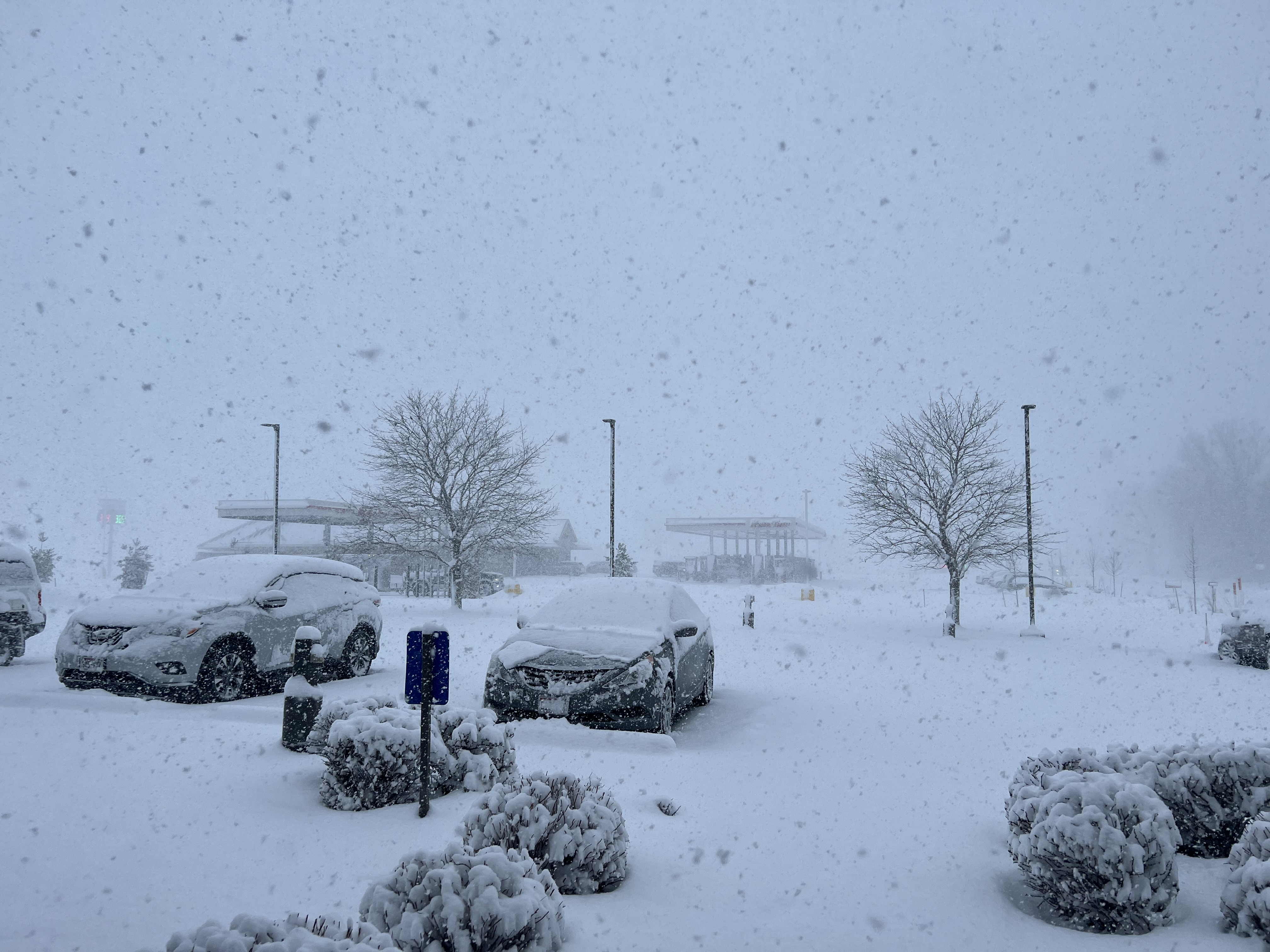
.jpg) Jacob Steinmetz - Darboy (Facebook) |
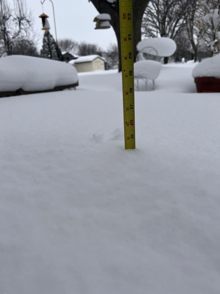 Jordyn Pegel - Appleton (Facebook) |
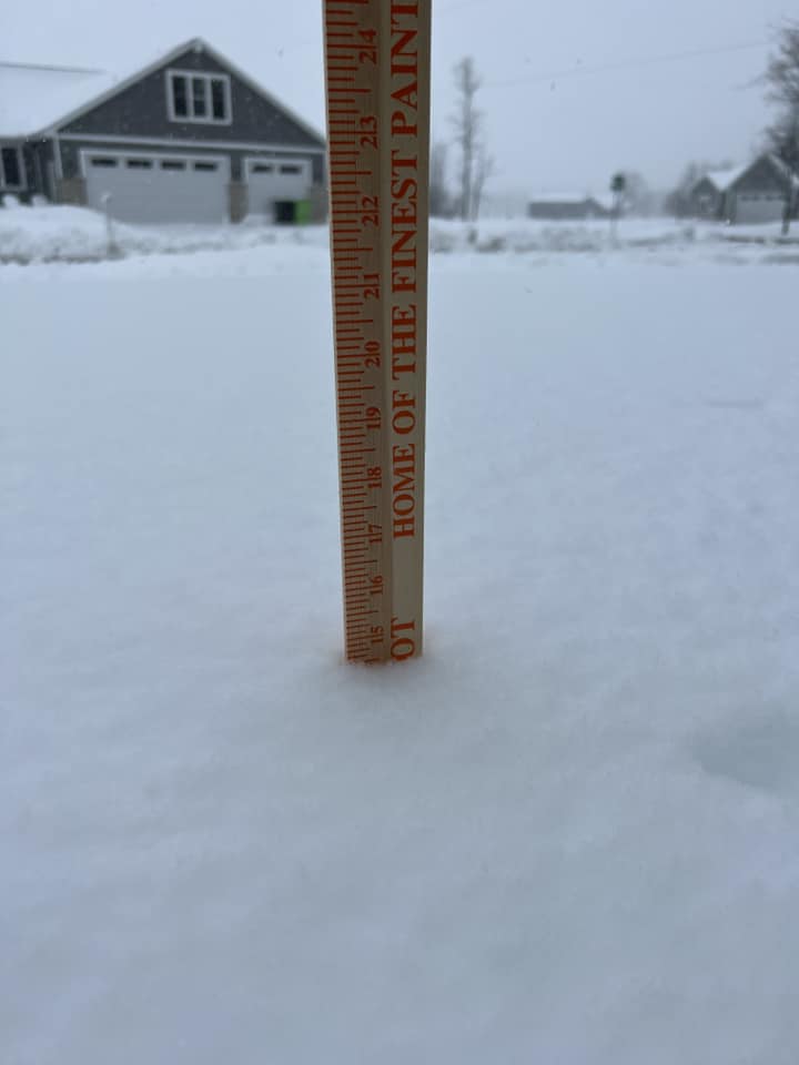 Kelly Anthony - Harrison (Facebook) |
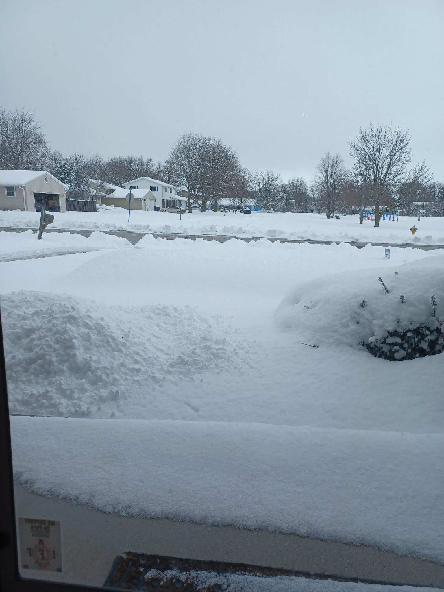 Mary Clark-Rinehard (Facebook) |
.jpg) Kevin Schwarten - Town of Rockland (snow rollers!) (Facebook) |
%2C%20Neenah%2C%20WI.jpg) Ed Korthals (dog Heidi) - Neenah (Facebook) |
 NWS Green Bay |
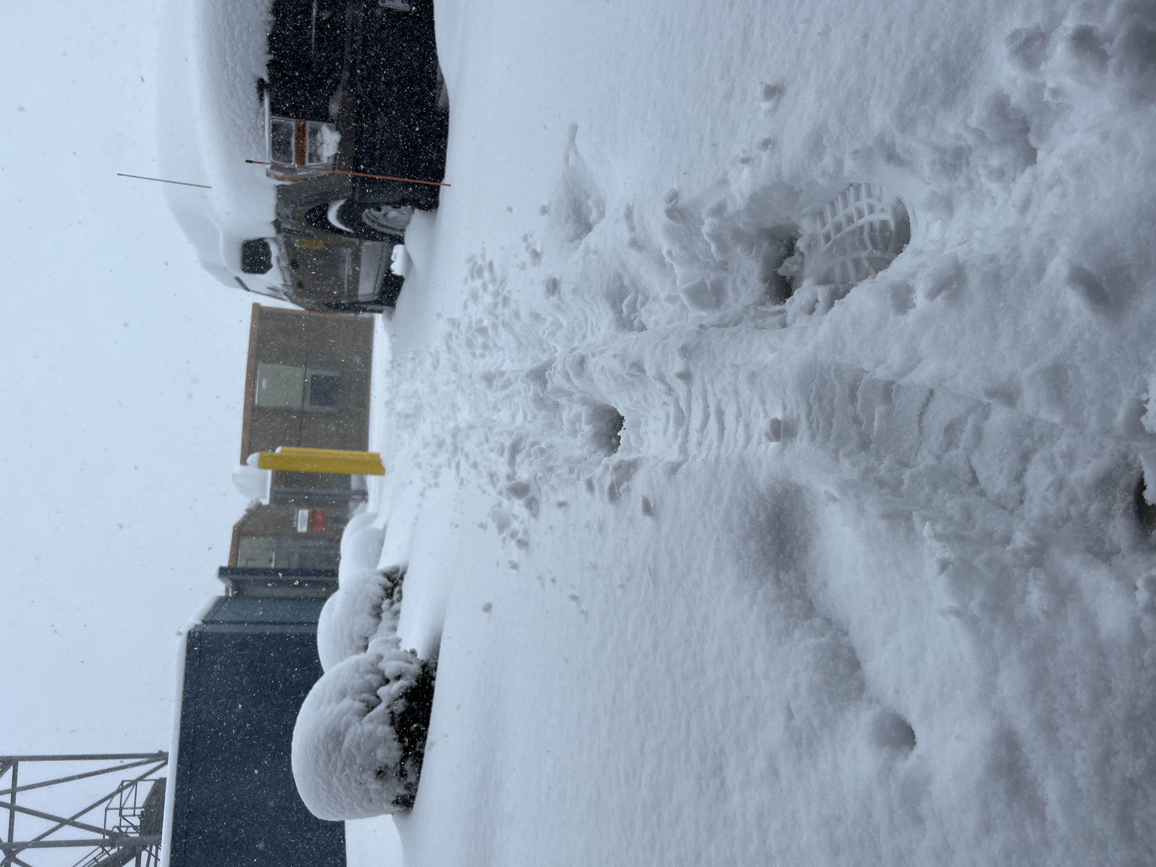 NWS Green Bay |
 |
Media use of NWS Web News Stories is encouraged! Please acknowledge the NWS as the source of any news information accessed from this site. |
|

