February 18, 2022: Strong Winds, Accumulating Snow, and Snow Squalls
A fast-moving clipper system moved across the Upper Mississippi Valley on Friday, February 18, 2022, that brought strong winds, accumulating snow, snow squalls, and very cold wind chills. Most locations across central and northeast Wisconsin received about 1 to 3 inches of snow. Strong south to southwest winds ahead of the clipper system, and strong west to northwest winds behind the system, created blowing and drifting snow across the region.
In addition, a snow squall developed along the clipper system's Arctic cold front, which caused occasional whiteout conditions and gusts as high as 62 mph. This prompted the issuance of multiple Snow Squall Warnings across central and east-central Wisconsin. In fact, these were officially the first Snow Squall Warnings issued by the NWS Green Bay office.
Radar
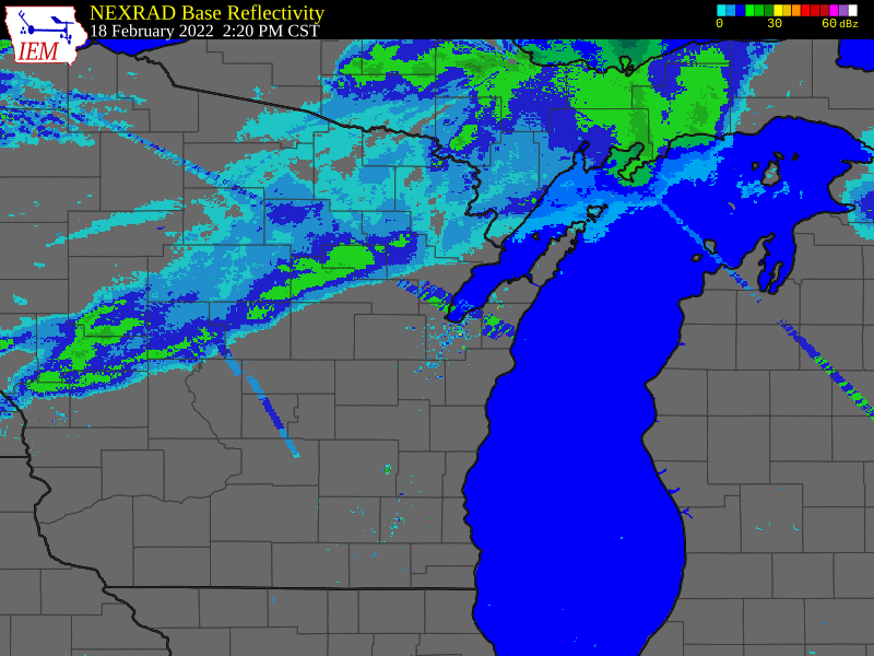 |
|
Radar Imagery from February 18, 2022 Between 2:20 PM to 8:30 PM CST
(Magenta colored polygons are Snow Squall Warnings.) |
Storm Reports
PRELIMINARY LOCAL STORM REPORT...SUMMARY
NATIONAL WEATHER SERVICE GREEN BAY WI
313 AM CST SAT FEB 19 2022

..TIME...   ...EVENT...      ...CITY LOCATION...     ...LAT.LON...
..DATE...   ....MAG....      ..COUNTY LOCATION..ST.. ...SOURCE....
            ..REMARKS..

0404 PM     HEAVY SNOW       WAUKAU                  44.00N 88.76W
02/18/2022  U0.0 INCH        WINNEBAGO          WI   ASOS

            SNOW SQUALL. VISIBILITY DROPPED TO A QUARTER OF A MILE.
            TIME ESTIMATED.

0515 PM     NON-TSTM WND GST WAUSAU                  44.96N 89.63W
02/18/2022  M54.00 MPH       MARATHON           WI   ASOS

0520 PM     NON-TSTM WND GST RHINELANDER             45.63N 89.41W
02/18/2022  M53.00 MPH       ONEIDA             WI   ASOS

0527 PM     NON-TSTM WND GST WISCONSIN RAPIDS        44.40N 89.84W
02/18/2022  M62.00 MPH       WOOD               WI   ASOS

0530 PM     HEAVY SNOW       WEYAUWEGA               44.31N 88.93W
02/18/2022  U0.0 INCH        WAUPACA            WI   TRAINED SPOTTER

            SNOW SQUALL. VISIBILITIES WERE A QUARTER OF A MILE OR
            LESS. WINDS ESTIMATED AT 40 TO 50 MPH.TIME ESTIMATED.

0602 PM     SNOW             ASHWAUBENON             44.46N 88.08W
02/18/2022  M0.2 INCH        BROWN              WI   OFFICIAL NWS OBS

            NWS GREEN BAY.

0602 PM     SNOW             PLOVER                  44.45N 89.53W
02/18/2022  M2.2 INCH        PORTAGE            WI   CO-OP OBSERVER

            STILL SNOWING AT THE TIME OF THE REPORT. WIND GUST TO 40
            MPH ALSO REPORTED.

0615 PM     NON-TSTM WND GST ANTIGO                  45.15N 89.15W
02/18/2022  M46.00 MPH       LANGLADE           WI   AWOS

0618 PM     NON-TSTM WND GST WAUSAU                  44.96N 89.63W
02/18/2022  M58.00 MPH       MARATHON           WI   ASOS

0630 PM     HEAVY SNOW       OSHKOSH                 44.01N 88.55W
02/18/2022  U0.0 INCH        WINNEBAGO          WI   ASOS

            SNOW SQUALL. VISIBILITY DROPPED TO A QUARTER OF A MILE
            WITH A GUST OF 35 MPH.

0631 PM     NON-TSTM WND GST GREEN BAY               44.51N 88.00W
02/18/2022  M54.00 MPH       BROWN              WI   ASOS

0645 PM     NON-TSTM WND GST SHERWOOD                44.17N 88.27W
02/18/2022  M56.00 MPH       CALUMET            WI   TRAINED SPOTTER

0647 PM     NON-TSTM WND GST WAUTOMA                 44.06N 89.28W
02/18/2022  M45.00 MPH       WAUSHARA           WI   AWOS

0656 PM     NON-TSTM WND GST MARSHFIELD              44.66N 90.16W
02/18/2022  M53.00 MPH       WOOD               WI   ASOS

0758 PM     SNOW             WRIGHTSTOWN             44.33N 88.16W
02/18/2022  M1.4 INCH        BROWN              WI   COCORAHS

0830 PM     SNOW             4 N IOLA                44.56N 89.11W
02/18/2022  E1.5 INCH        WAUPACA            WI   TRAINED SPOTTER

            CONSIDERABLE BLOWING AND DRIFTING SNOW ON HIGHWAY 10 AND
            HIGHWAY 49.

0925 PM     SNOW             ASHWAUBENON             44.46N 88.08W
02/18/2022  M0.9 INCH        BROWN              WI   OFFICIAL NWS OBS

            STORM TOTAL.
Maximum Wind Gusts
PUBLIC INFORMATION STATEMENT
NATIONAL WEATHER SERVICE GREEN BAY WI
1052 AM CST SAT FEB 19 2022

...HIGHEST WIND GUST REPORTS OVER PAST 24 HOURS...

LOCATION                     SPEED     TIME/DATE       LAT/LON
WISCONSIN RAPIDS AIRPORT     62 MPH    0527 PM 02/18   44.37N/89.83W
WAUSAU AIRPORT               58 MPH    0618 PM 02/18   44.93N/89.62W
GREEN BAY AIRPORT            54 MPH    0926 PM 02/18   44.48N/88.13W
MARSHFIELD AIRPORT           53 MPH    0634 PM 02/18   44.63N/90.18W
RHINELANDER AIRPORT          53 MPH    0520 PM 02/18   45.63N/89.48W
FOREST JUNCTION              52 MPH    0837 PM 02/18   44.21N/88.21W
MANITOWOC                    50 MPH    0910 PM 02/18   44.09N/87.66W
WAUTOMA AIRPORT              49 MPH    0809 PM 02/18   44.03N/89.30W
OSHKOSH AIRPORT              48 MPH    1013 PM 02/18   43.97N/88.55W
ANTIGO AIRPORT               47 MPH    0735 PM 02/18   45.15N/89.12W
WAUPACA                      47 MPH    0715 PM 02/18   44.33N/89.02W
REEDSVILLE                   46 MPH    0701 PM 02/18   44.23N/87.96W
WHITELAW                     46 MPH    0910 PM 02/18   44.18N/87.84W
APPLETON AIRPORT             46 MPH    0715 PM 02/18   44.27N/88.52W
CLINTONVILLE AIRPORT         46 MPH    0815 PM 02/18   44.62N/88.73W
MANITOWOC AIRPORT            46 MPH    0832 PM 02/18   44.12N/87.67W
DE PERE                      45 MPH    0130 PM 02/18   44.44N/88.05W
KEWAUNEE MET, WI             45 MPH    1006 PM 02/18   44.47N/87.50W
MARSHFIELD                   45 MPH    0700 PM 02/18   44.76N/90.10W
EGG HARBOR 3.1 SE (MAWN)     45 MPH    1000 PM 02/18   45.01N/87.23W
WRIGHTSTOWN                  44 MPH    1009 PM 02/18   44.33N/88.17W
GREEN BAY                    44 MPH    0901 PM 02/18   44.49N/88.09W
GREEN BAY 1 N                44 MPH    0800 PM 02/18   44.54N/88.00W
MOSINEE AIRPORT              44 MPH    0647 PM 02/18   44.78N/89.67W
EAGLE RIVER AIRPORT          44 MPH    0555 PM 02/18   45.93N/89.27W
KESHENA 2 WNW                44 MPH    0905 PM 02/18   44.89N/88.66W
OCONTO AIRPORT               44 MPH    0715 PM 02/18   44.87N/87.92W
MENOMINEE                    44 MPH    0900 PM 02/18   45.10N/87.59W
PLOVER                       43 MPH    0916 PM 02/18   44.44N/89.55W
EPHRAIM                      43 MPH    0855 PM 02/18   45.13N/87.18W
STEVENS POINT AIRPORT        43 MPH    0615 PM 02/18   44.55N/89.53W
MOON 6 SW                    42 MPH    0905 PM 02/18   44.70N/89.87W
WAUSAU                       41 MPH    0611 PM 02/18   44.95N/89.61W
SEYMOUR                      41 MPH    0915 PM 02/18   44.54N/88.25W
BREED 5 NE                   41 MPH    0703 PM 02/18   45.12N/88.37W
ELLISON BAY 2.2 S (MAWN)     41 MPH    1000 PM 02/18   45.22N/87.07W
ANTIGO 2 ENE                 40 MPH    0705 PM 02/18   45.16N/89.11W
GREEN BAY                    40 MPH    0745 PM 02/18   44.58N/88.09W
TWO CREEKS                   40 MPH    1010 PM 02/18   44.27N/87.55W
1 ENE GILLS ROCK             40 MPH    0940 PM 02/18   45.29N/86.98W
MANITOWISH WATERS AIRPORT    39 MPH    0515 PM 02/18   46.12N/89.88W
SHAWANO AIRPORT              39 MPH    0955 PM 02/18   44.78N/88.57W
STURGEON BAY AIRPORT         39 MPH    1019 PM 02/18   44.85N/87.42W
TOMAHAWK AIRPORT             39 MPH    0655 PM 02/18   45.47N/89.82W
OMRO                         38 MPH    0340 AM 02/19   44.03N/88.75W
APPLETON                     38 MPH    0707 PM 02/18   44.29N/88.46W
MAPLEWOOD 1.4 W (MAWN)       38 MPH    0900 PM 02/18   44.76N/87.51W
RHINELANDER                  38 MPH    0800 PM 02/18   45.65N/89.27W
WAUTOMA 1 WSW                38 MPH    0812 PM 02/18   44.06N/89.29W
WAUSAU                       37 MPH    0655 PM 02/18   44.95N/89.64W
WASHINGTON ISLAND            37 MPH    0155 PM 02/18   45.38N/86.92W
LAND O LAKES                 37 MPH    0555 PM 02/18   46.15N/89.22W
WABENO 2 NNW                 37 MPH    0701 PM 02/18   45.46N/88.68W
LUXEMBURG 2.0 NE (MAWN)      37 MPH    0900 PM 02/18   44.56N/87.65W
ARBOR VITAE AIRPORT          36 MPH    0555 PM 02/18   45.92N/89.72W
TOMAHAWK 3 W                 36 MPH    0810 PM 02/18   45.59N/89.72W
WINCHESTER                   35 MPH    0505 PM 02/18   46.23N/89.83W
WAUSAUKEE 2 NW               35 MPH    0905 PM 02/18   45.39N/87.97W

OBSERVATIONS ARE COLLECTED FROM A VARIETY OF SOURCES WITH VARYING
EQUIPMENT AND EXPOSURES. WE THANK ALL VOLUNTEER WEATHER OBSERVERS
FOR THEIR DEDICATION. NOT ALL DATA LISTED ARE CONSIDERED OFFICIAL.
 |
Media use of NWS Web News Stories is encouraged! Please acknowledge the NWS as the source of any news information accessed from this site. |
|

