
Heat expands across the Desert Southwest, Plains, Mississippi Valley and Midwest into Monday. Fire weather concerns continue for portions of the Intermountain West. Active monsoonal moisture fuels thunderstorms over the Southwest with possible flash flooding. Tropical cyclone Fausto in the Pacific, should weaken as it approaches Hawaii; Dangerous surf, swells and rip currents are expected. Read More >
Overview
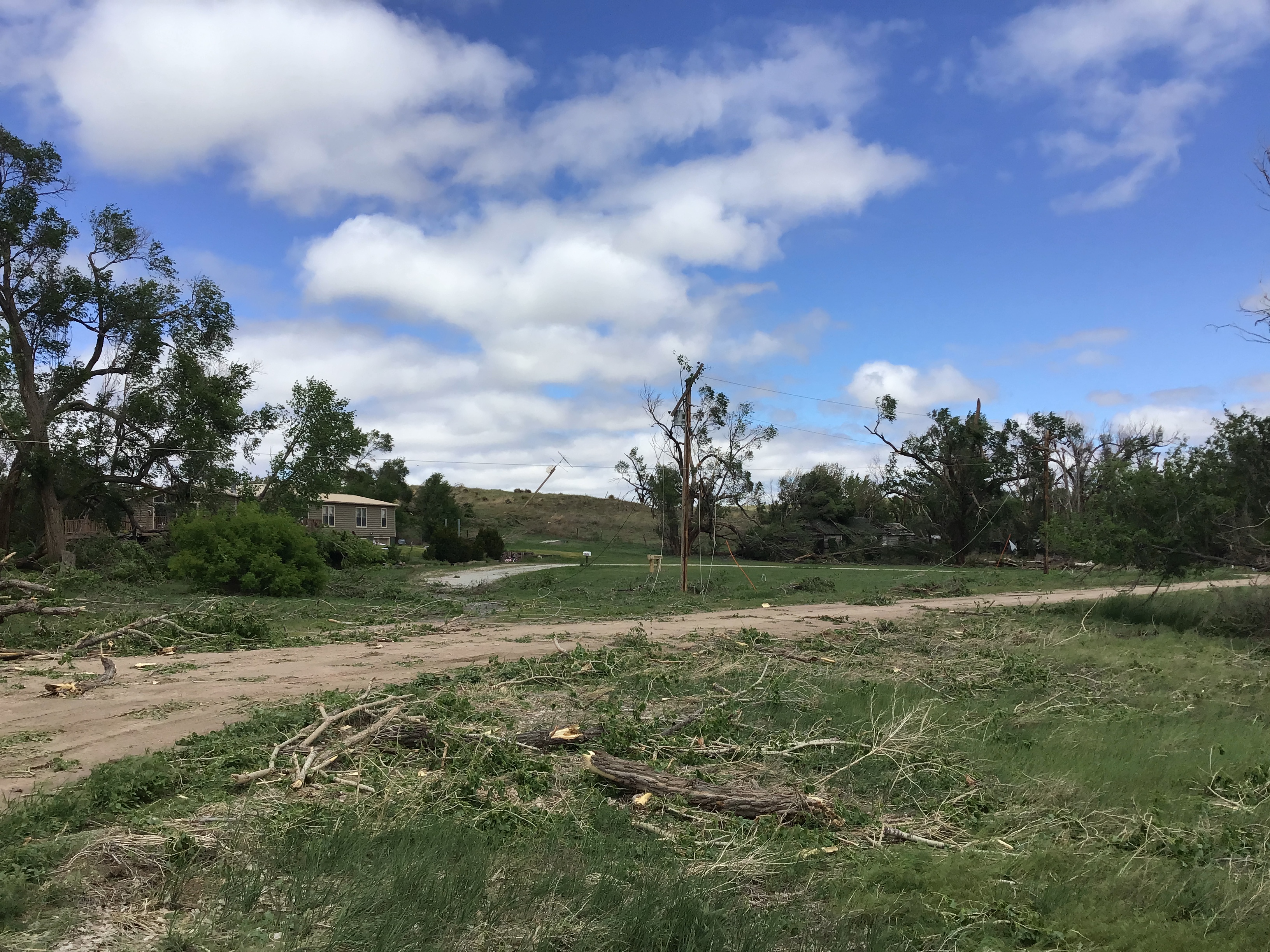
An intense supercell thunderstorm moved eastward across Yuma County Colorado and Dundy County Nebraska during the evening of the 20th. The thunderstorm produced hail up to softball size and straight-line wind gusts over 100 MPH, based on damage. The largest hail occurred near Yuma, CO while the most intense winds occurred over Dundy County, specifically near the Parks, NE area. The swath of the most intense winds ended just east of Parks. You can view the official summary here.
Wind & Hail:
Wind
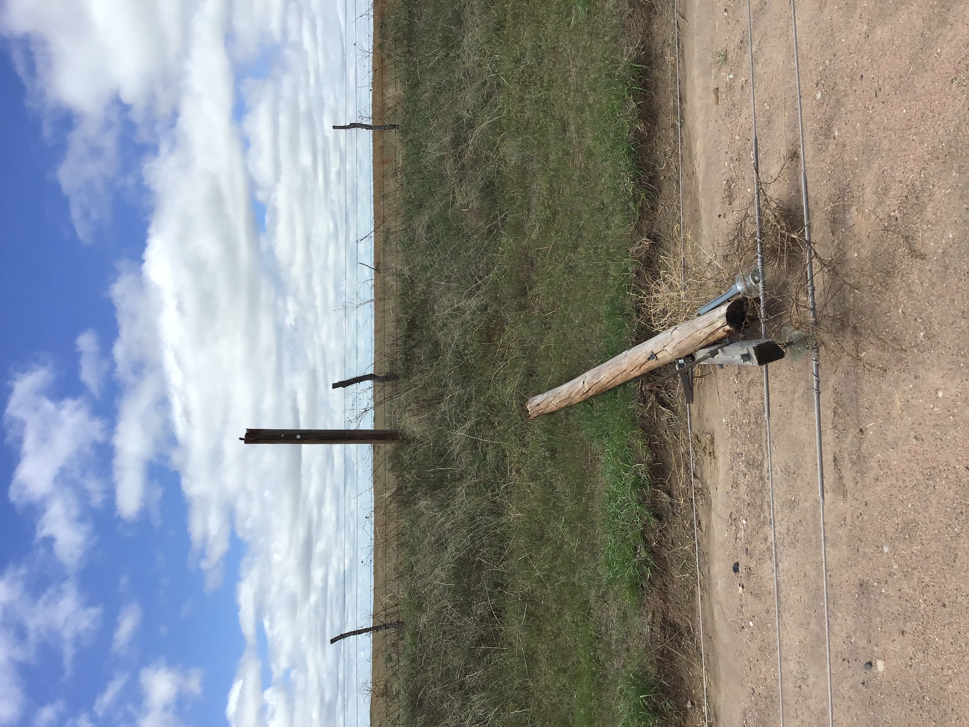
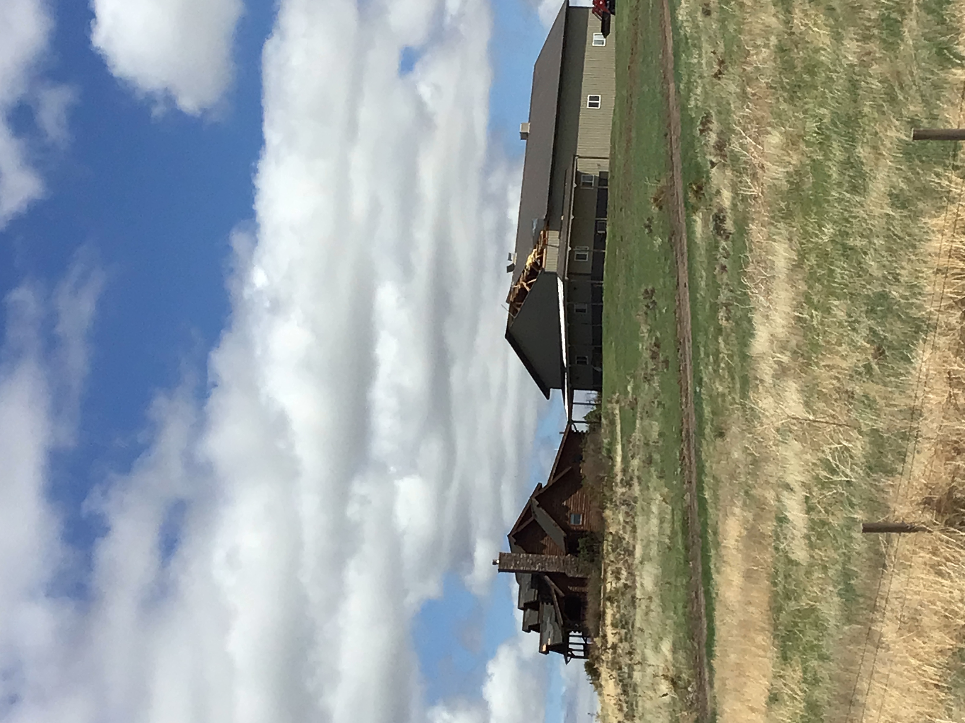
Wind gusts up to an estimated 118 MPH occurred near Parks, NE. The highest gusts, estimated by the damage, occurred north of Parks where power poles were snapped. Four power poles were also snapped west of Parks on Highway 34. Here is a map of the points that were surveyed.
 |
 |
 |
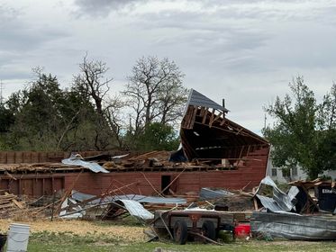 |
| Large tree limbs down and an electric pole leaning in Parks, NE. | One electrical pole, of 13 in one stretch, that were snapped north of Parks, NE. | Roof damage west of Parks, NE. | Pre-1930s era barn destroyed west of Parks, NE. |
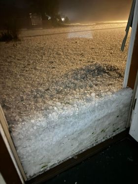
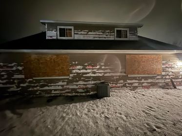
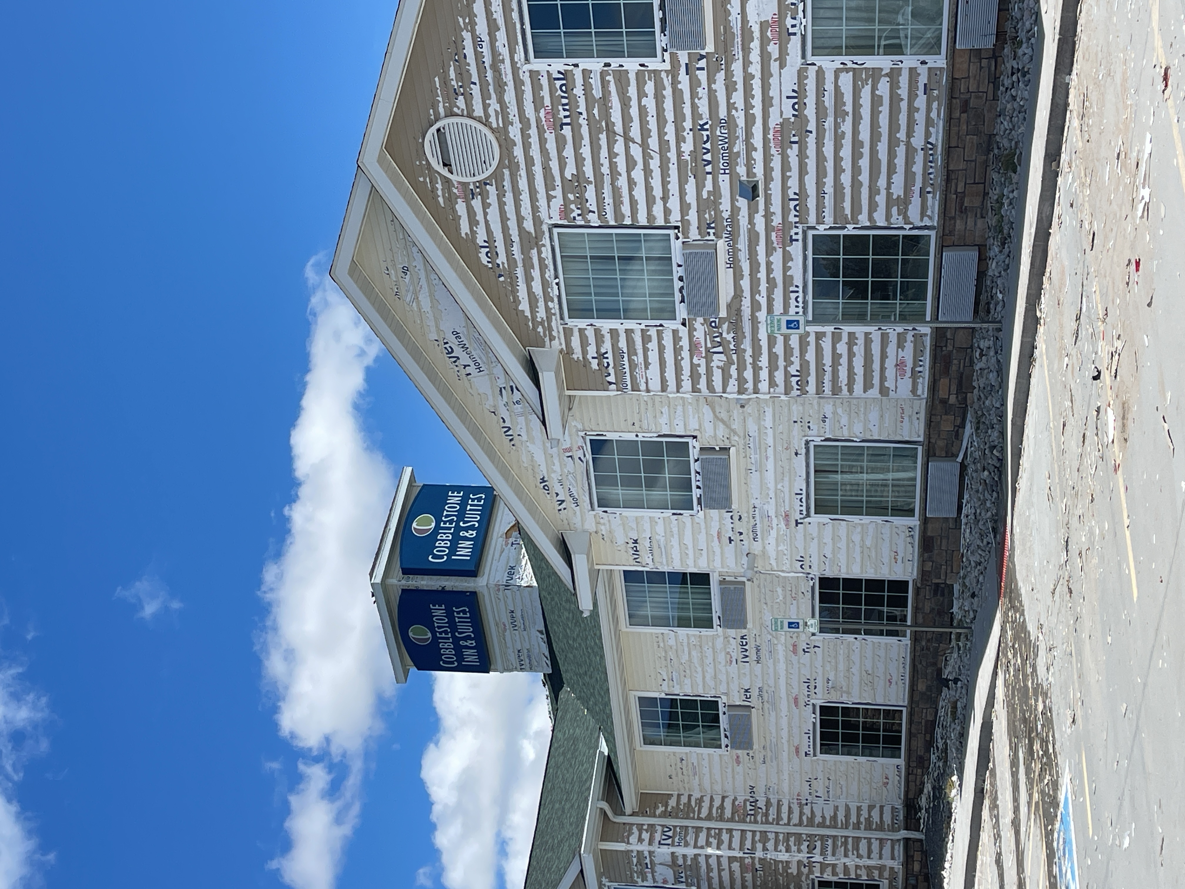
Hail:
Hail
The worst of the hail was reported around Yuma, CO. The largest hail reported near Yuma was softball size. Wind gusts over 70 MPH also occurred with the hail. Here is a map of the survey points for the hail.
 |
 |
 |
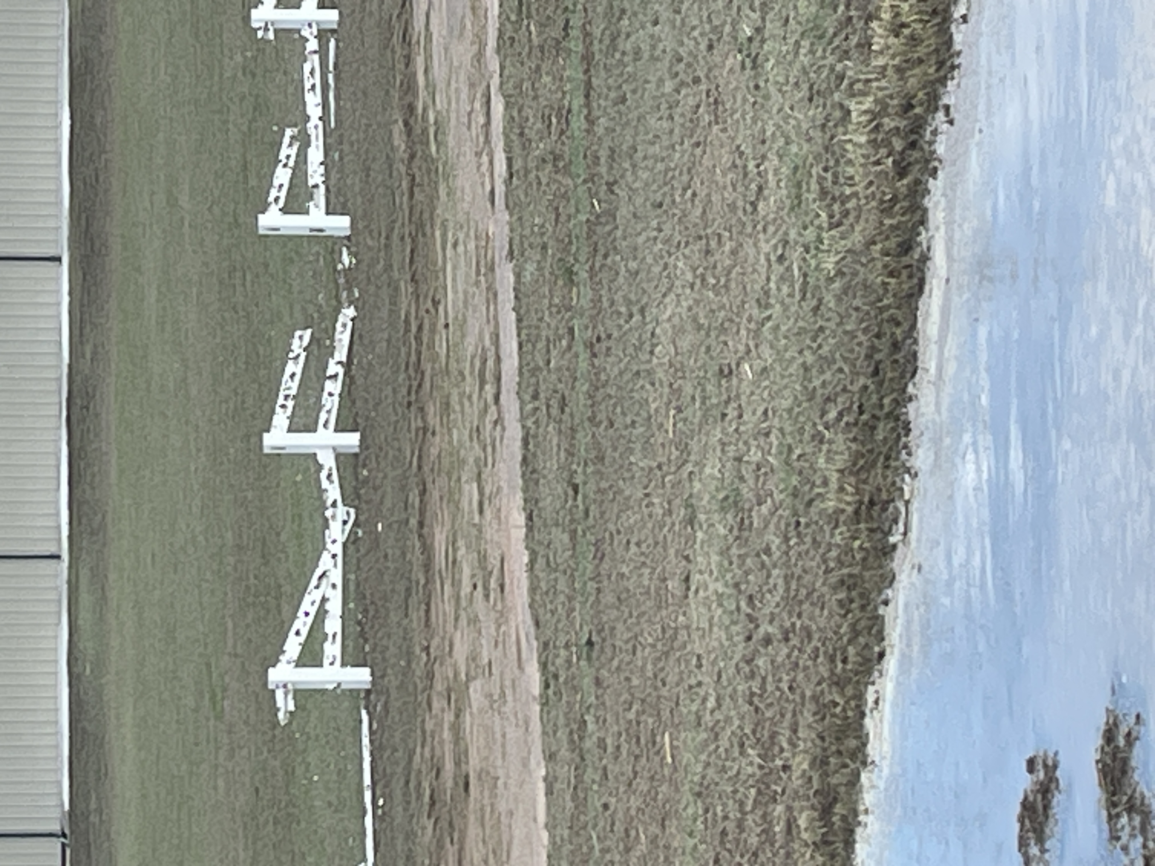 |
| Accumulating hail in Yuma, CO. | Hail damage to a house after the storm in Yuma, CO. | Siding damage from hail storm in Yuma, CO. | Vinyl fence destroyed from hail in Yuma, CO. |
Radar:
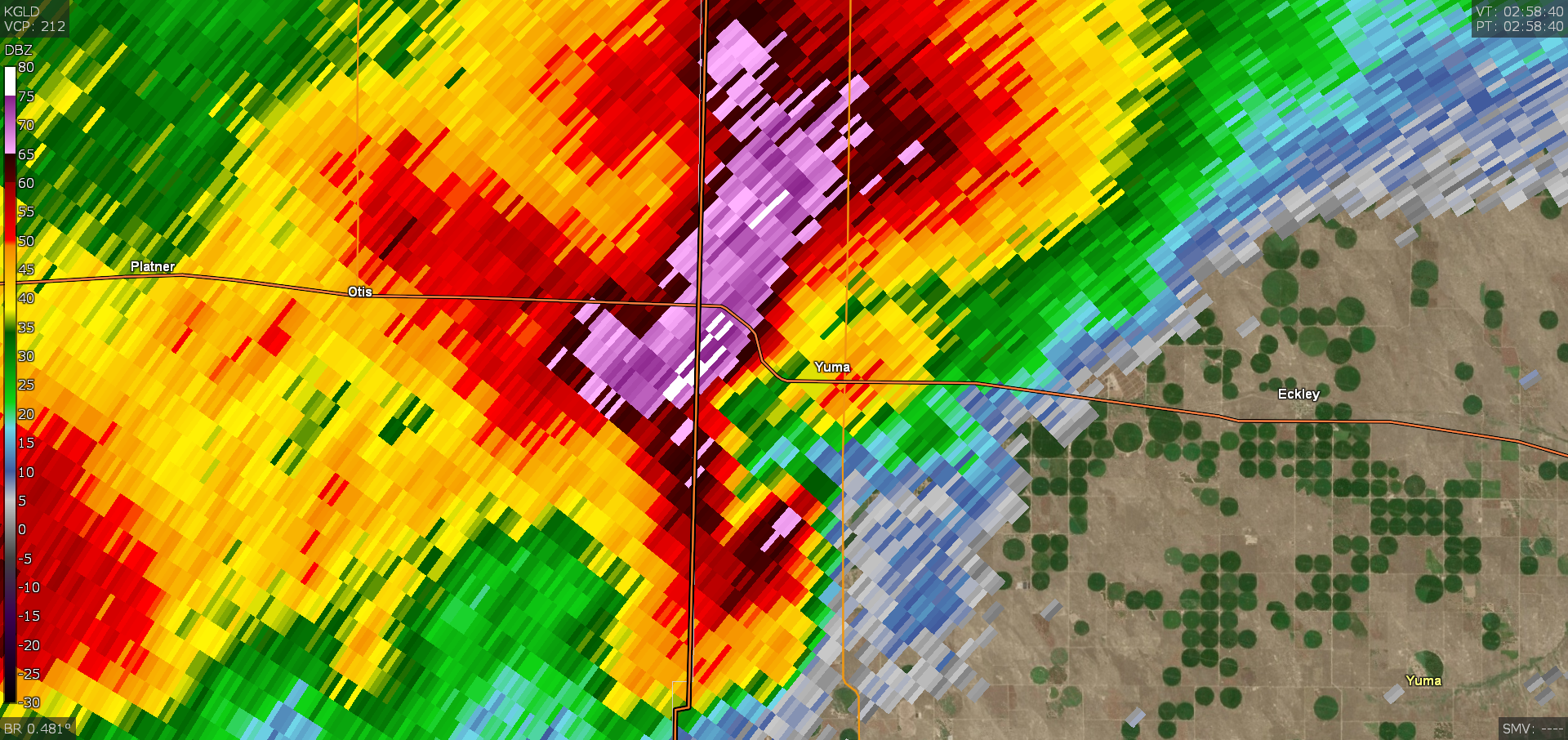
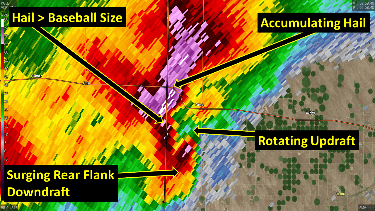
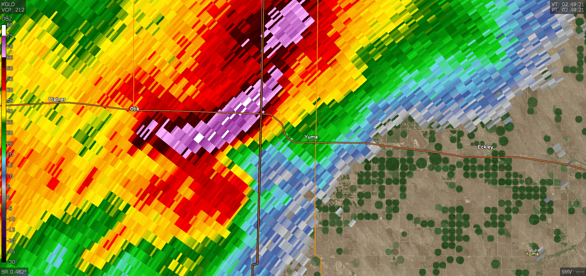
Radar
 |
 |
 |
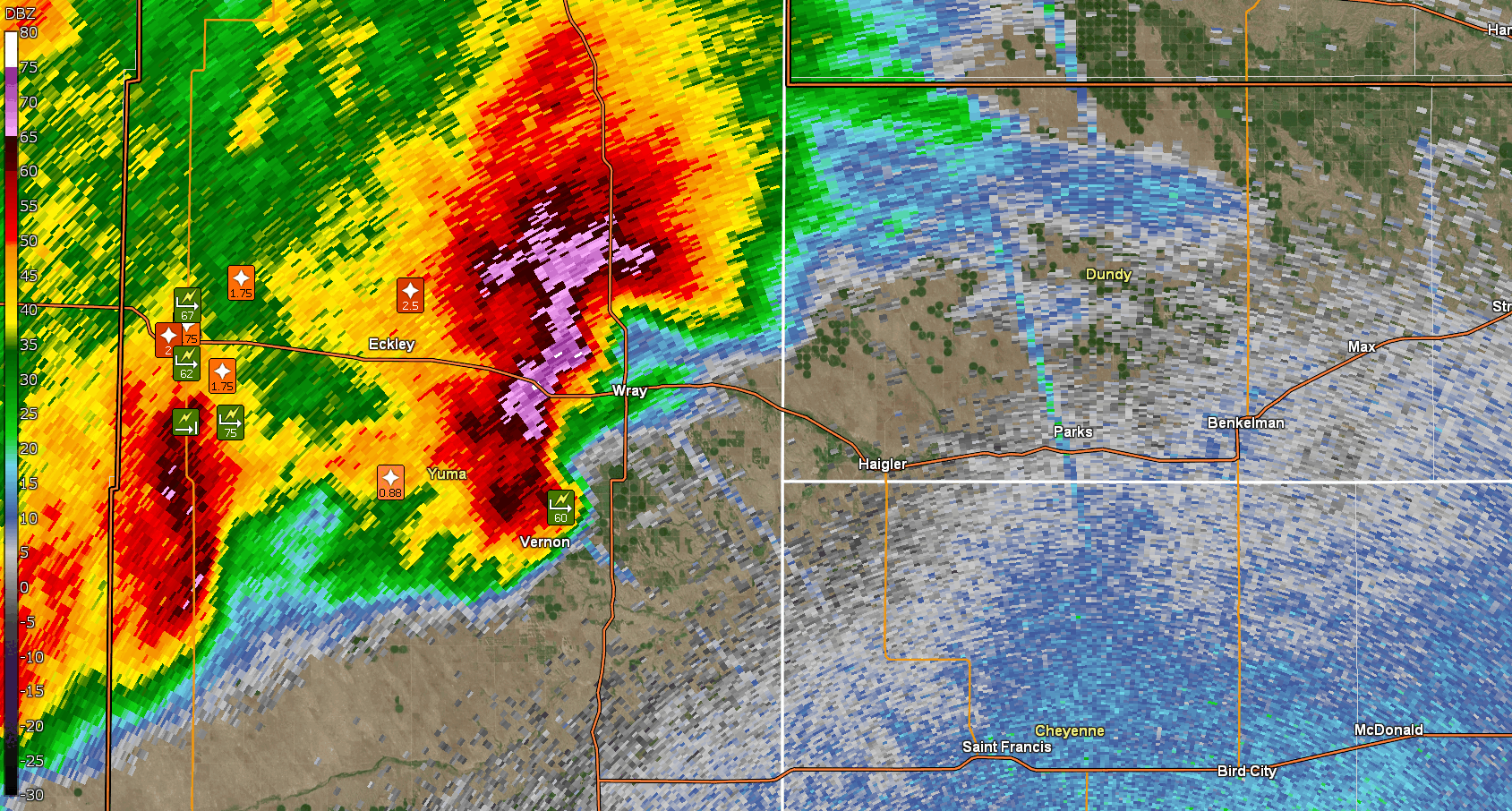 |
| 858 PM MDT Reflectivity storm approaching Yuma. | 858 PM MDT Annotated Reflectivity | 849 PM MDT to 910 PM MDT Loop. Notice southern portion of storm surge to the east, indicative of strong winds. | 1005 PM MDT to 1200 AM MDT loop showing development of intense bow echo. Storm reports also listed. Notice how the whole system begins to rotate at end of the loop! |
Storm Reports
Preliminary Local Storm Report...Summary...Corrected
National Weather Service Goodland KS
922 PM MDT Tue May 21 2024

..TIME...   ...EVENT...      ...CITY LOCATION...     ...LAT.LON...
..DATE...   ....MAG....      ..COUNTY LOCATION..ST.. ...SOURCE....
            ..REMARKS..

0600 AM     Rain             2 NNW Blakeman          39.84N 101.13W
05/21/2024  M0.28 Inch       Rawlins            KS   Trained Spotter

            0.28 inches of rain as of time of report.

0129 AM     Hail             1 SW Bartley            40.24N 100.32W
05/21/2024  E0.70 Inch       Red Willow         NE   Trained Spotter

            Penny to dime sized hail reported 1 mile
            southwest of Bartley.

0950 PM     Hail             6 NE Heartstrong        40.00N 102.49W
05/20/2024  E0.88 Inch       Yuma               CO   Trained Spotter

            Corrects previous hail report from 6 NE
            Heartstrong.

0932 PM     Hail             4 N Eckley              40.16N 102.47W
05/20/2024  M1.00 Inch       Yuma               CO   Public

            Report from mPING: Quarter (1.00 in.).

1045 PM     Hail             1 N Vernon              39.94N 102.28W
05/20/2024  E1.00 Inch       Yuma               CO   Public

            Public report via social media of quarter
            hail 1/2 mile north of Vernon, CO.

0700 AM     Rain             2 NNE Hale              39.66N 102.12W
05/21/2024  M1.13 Inch       Yuma               CO   Trained Spotter

            1.13 inches of rain as of time of report.

1046 PM     Hail             1 E Haigler             40.02N 101.91W
05/20/2024  E1.25 Inch       Dundy              NE   Public

            Report from mPING: Half Dollar (1.25 in.).

1028 PM     Hail             Wray                    40.08N 102.22W
05/20/2024  M1.25 Inch       Yuma               CO   Public

            Public report and photos via social media of
            hail ranging from 1-1.25 inch diameter.

0700 AM     Rain             Haigler                 40.01N 101.94W
05/21/2024  M1.50 Inch       Dundy              NE   Trained Spotter

            Spotter reports 1.5 inches of rain.

0933 PM     Hail             4 N Eckley              40.16N 102.47W
05/20/2024  E1.50 Inch       Yuma               CO   Public

            Report from mPING: Ping Pong Ball (1.50
            in.).

1015 PM     Hail             1 E Wray                40.08N 102.21W
05/20/2024  E1.50 Inch       Yuma               CO   Public

            Report and photo of approx. ping pong ball
            size hail at the east end of Wray, CO at
            10:15 PM MDT.

1145 PM     Hail             12 W Palisade           40.34N 101.33W
05/20/2024  E1.75 Inch       Dundy              NE   Public

            Golf ball size hail reported 14 miles NNW of
            Stratton, NE. Time estimated from radar.

0910 PM     Hail             1 NNE Yuma              40.13N 102.72W
05/20/2024  E1.75 Inch       Yuma               CO   Public

            Report and photos via social media of hail
            up to golf ball size but mostly smaller
            stones with drifts estimated from photos to
            be up to around 1 foot tall. Wind driven
            hail broke windows and damaged siding. Time
            estimated from radar.

0914 PM     Hail             3 SE Yuma               40.09N 102.68W
05/20/2024  E1.75 Inch       Yuma               CO   Trained Spotter

            quarter to golf ball sized hail.

0920 PM     Hail             5 NE Yuma               40.17N 102.66W
05/20/2024  E1.75 Inch       Yuma               CO   Public

            Corrects previous hail report from 5 NE
            Yuma. Report and photos via social media
            (X), varying hail sizes up to golf ball
            size. Lots of windows broke out, hail
            covering ground. Time corrected, radar
            estimated.

1010 PM     Hail             Wray                    40.08N 102.22W
05/20/2024  E1.75 Inch       Yuma               CO   Public

            Report and photos via social media of
            approx. golf ball size hail in Wray, CO.

1015 PM     Hail             Wray                    40.08N 102.22W
05/20/2024  E1.75 Inch       Yuma               CO   Public


1015 PM     Hail             4 NNE Wray              40.14N 102.20W
05/20/2024  E1.75 Inch       Yuma               CO   Cocorahs

            CoCoRAHS report of golf ball size hail.
            Report of shredded leaves, car dents,
            damaged shingles, and broken house and car
            windows. Time estimated from radar.

1155 PM     Hail             8 NNW Stratton          40.26N 101.28W
05/20/2024  E2.00 Inch       Hitchcock          NE   Trained Spotter

            Trained spotter reporting hail between the
            sizes of golf balls and hen eggs.

1215 AM     Hail             Palisade                40.35N 101.11W
05/21/2024  E2.00 Inch       Hitchcock          NE   Public

            Public report and photo via social media of
            hail in Palisade; sizes estimated from photo
            ranging from approx. half dollar size to
            around 2 inches in diameter. Time estimated
            from radar.

0910 PM     Hail             1 WSW Yuma              40.12N 102.74W
05/20/2024  M2.00 Inch       Yuma               CO   Public

            2 inch hail reported on the southwest side
            of Yuma, started around 9:10 PM MDT and
            lasted approx. 15 minutes. Location
            estimated.

1217 AM     Hail             Palisade                40.35N 101.11W
05/21/2024  E2.50 Inch       Hitchcock          NE   Public

            Report and photo via social media of hail
            estimated from photo to be around the size
            of a tennis ball. Hail was reported to have
            varied in size.

1130 PM     Hail             12 N Max                40.28N 101.42W
05/20/2024  E2.50 Inch       Dundy              NE   Public

            Report and photo via social media (X) of
            around tennis ball size hail in northeast
            Dundy county.

0943 PM     Hail             4 N Eckley              40.16N 102.47W
05/20/2024  M2.50 Inch       Yuma               CO   Public

            Report from mPING: Tennis Ball (2.50 in.).

0902 AM     Rain             6 NE Heartstrong        40.00N 102.49W
05/21/2024  M2.50 Inch       Yuma               CO   Trained Spotter

            Storm total.

0900 PM     Hail             Yuma                    40.12N 102.72W
05/20/2024  E2.75 Inch       Yuma               CO   Public

            Report and photos via social media (X) of
            accumulating hail and hail drifts in Yuma.
            Biggest stones baseball size or larger with
            most stones 1 to 2.25 inch.

0900 PM     Hail             1 S Yuma                40.11N 102.72W
05/20/2024  E4.00 Inch       Yuma               CO   Emergency Mngr

            Emergency manager reports fire department
            had tennis to softball size hail about 1
            mile south of Yuma.

0905 PM     Tstm Wnd Gst     2 N Yuma                40.15N 102.72W
05/20/2024  M51 MPH          Yuma               CO   Mesonet

            Mesonet station YUM02 2 N Yuma 2.

0902 PM     Tstm Wnd Gst     4 E Yuma                40.13N 102.65W
05/20/2024  M52 MPH          Yuma               CO   Mesonet

            WeatherLink site Yuma Dairy.

1125 PM     Tstm Wnd Gst     19 NW Max               40.32N 101.62W
05/20/2024  M54 MPH          Dundy              NE   Mesonet

            Mesonet station NB086 Enders 10SW.

1031 PM     Tstm Wnd Gst     5 NE Vernon             39.98N 102.20W
05/20/2024  M59 MPH          Yuma               CO   Mesonet

            Weatherlink site Osmus Farm.

1004 PM     Tstm Wnd Gst     3 NNW Vernon            39.98N 102.30W
05/20/2024  M60 MPH          Yuma               CO   Mesonet

            Weatherlink site Welp Farms.

1053 PM     Tstm Wnd Gst     6 NNE Haigler           40.09N 101.89W
05/20/2024  M61 MPH          Dundy              NE   Mesonet

            Weatherlink site Brunswig Shop.

0914 PM     Tstm Wnd Gst     2 SSE Yuma              40.10N 102.72W
05/20/2024  M62 MPH          Yuma               CO   AWOS

            Corrects previous tstm wnd gst report from 2
            SSE Yuma. The AWOS in Yuma (K2V6) measured
            NNW winds sustained at 48 mph gusting to 62
            mph at 914 pm MDT.

1015 PM     Tstm Wnd Gst     2 NW Wray               40.10N 102.25W
05/20/2024  M63 MPH          Yuma               CO   AWOS

            AWOS station K2V5 2 NW Wray.

1107 PM     Tstm Wnd Gst     13 NNW Benkelman        40.23N 101.61W
05/20/2024  M66 MPH          Dundy              NE   Mesonet

            Weatherunderground site KNEBENKE10. Wind
            direction from the north-northeast.

0915 PM     Tstm Wnd Gst     2 N Yuma                40.15N 102.72W
05/20/2024  M67 MPH          Yuma               CO   Mesonet

            Mesonet station YUM02 2 N Yuma 2.

1040 PM     Tstm Wnd Gst     3 S Wray                40.04N 102.23W
05/20/2024  E70 MPH          Yuma               CO   Storm Chaser

            Report of estimated 70 mph wind gusts on Hwy
            385 approx. 3.5 to 1.5 miles south of Hwy 34
            in Wray.

0916 PM     Tstm Wnd Gst     6 SSE Yuma              40.05N 102.67W
05/20/2024  M75 MPH          Yuma               CO   Mesonet

            Weatherunderground site KCOYUMA29.

0950 PM     Tstm Wnd Gst     6 NE Heartstrong        40.00N 102.49W
05/20/2024  M75 MPH          Yuma               CO   Trained Spotter

            occurred with nickel size hail.

1112 PM     Tstm Wnd Gst     Parks                   40.04N 101.73W
05/20/2024  M91 MPH          Dundy              NE   Mesonet

            Personal weather station in Parks, NE
            measured a wind gust of 91 mph. Report
            carport is gone and a camper was blown out
            of the carport.

1054 PM     Tstm Wnd Gst     6 NNE Haigler           40.09N 101.89W
05/20/2024  M93 MPH          Dundy              NE   Mesonet

            Weatherlink site Brunswig Shop.

1050 PM     Tstm Wnd Dmg     8 N Haigler             40.12N 101.93W
05/20/2024                   Dundy              NE   Trained Spotter

            Corrects time on previous tstm wnd dmg
            report from 8 N Haigler. Spotter reported
            uprooted trees and some building damage.

1100 PM     Tstm Wnd Dmg     4 WSW Parks             40.03N 101.81W
05/20/2024                   Dundy              NE   Public

            Report and photos via social media of downed
            trees and damage to a barn and grain bin
            approx. 13 miles west of Benkelman. Time
            estimated from radar.

0126 AM     Flash Flood      Atwood                  39.81N 101.05W
05/21/2024                   Rawlins            KS   Public

            Report from mPING: Street/road flooding;
            Street/road closed; Vehicles stranded.

0936 PM     Tstm Wnd Dmg     5 S Yuma                40.05N 102.72W
05/20/2024                   Yuma               CO   Storm Chaser

            Several power poles snapped near the
            intersection of CR 33 and Hwy 59.

1015 PM     Flash Flood      1 SSE Yuma              40.12N 102.72W
05/20/2024                   Yuma               CO   Trained Spotter

            Spotter reported that streets and basements
            are flooding in the city of Yuma at 10:15 pm
            MDT.

1025 PM     Tornado          5 S Laird               40.00N 102.09W
05/20/2024                   Yuma               CO   Trained Spotter

            Report of a possible tornado near the
            CO/KS/NE border viewed in lightning flashes
            an estimated 7-8 miles northwest from Co Rd
            Z and Co Rd 5 in Cheyenne county KS.


&&

$$
 |
Media use of NWS Web News Stories is encouraged! Please acknowledge the NWS as the source of any news information accessed from this site. |
|

