| Each spring, water from melting winter snows, combined with rainfall upon the snow or frozen ground, can cause flooding along the Mississippi River. The initial spring flood outlook in February 2001 called for locations to stay at or below flood stage. However, March storms brought significant snows to parts of Minnesota and Wisconsin. Cold temperatures in the north helped limit the amount of melting of the snow pack, although locations such as La Crosse, WI, Winona, MN and points south lost their snow cover by the end of March. |
|
|||||||||||||||||||||||||||||
On April 5th and 6th, and then again on the 11th, showers and thunderstorms brought heavy rains to the Upper Mississippi River Valley. These rains, in excess of several inches in some locations, caused a rapid snow melt. Water from this snow melt, in addition to rain itself, funneled into area streams, creeks and rivers, causing rapid rises and flooding. Eventually, most of this water flowed into the Mississippi River.
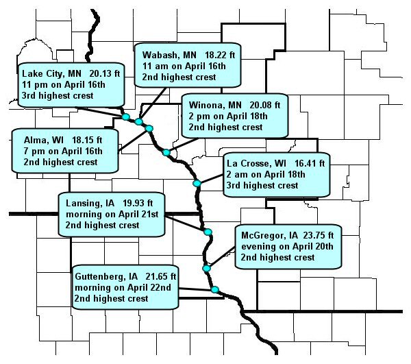
The Mississippi River responded quickly for a river of its size, reaching flood stage from the impact of the first rains within a week. The additional rainfall on the 11th had the added impact of not only increasing the height of the crests, but extending the length of time locations remained above flood stage (Table 1). The last site in the local area finally dropped below flood stage on May 18th. Some tributaries went above flood stage more than once. The flood brought the 2nd to 3rd highest crest on record to many Mississippi River locations (Fig 1). In addition, the flooding brought national media to the region, with live reports as the river reached its crests.
