High Winds of March 9, 2002
An intense late winter storm developed over the plains of Colorado on Friday, March 8th. The stormed moved slowly southeast into Kansas along a nearly stationary cold front. As the low moved into Kansas, it strengthened to a central pressure of 992 millibars or about 29.29 inches of mercury. The storm began to move northeast toward the upper Midwest overnight Friday and continued to strengthen as it did. By mid-day Saturday the 9th, the low had reached Lake Superior and had intensified to 988 millibars or about 29.18 inches of mercury. Strong northwest winds spread over the entire region Saturday and continued into Saturday evening. The highest wind gusts, between 40 and 60 mph, occurred during the day Saturday. The combination of the winds, falling snow and snow on the ground, combined to produce blizzard or near blizzard conditions over parts of southeast Minnesota and northeast Iowa Saturday. The winds decreased overnight Saturday as the storm moved into southern Canada.
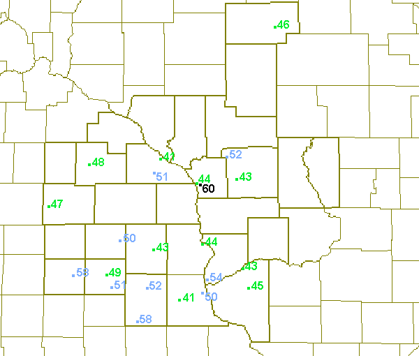
Peak wind gusts for March 9th.
ZCZC MKEPNSLSE
ABUS34 KLSE 100311

PUBLIC INFORMATION STATEMENT
NATIONAL WEATHER SERVICE LA CROSSE WI
910 PM CST SAT MAR 9 2002

THE FOLLOWING ARE PEAK WIND GUSTS TODAY AS OF 8 PM.

     LOCATION            COUNTY          PEAK WIND GUSTS

...IOWA...
CHARLES CITY             FLOYD               58 MPH
CRESCO                   HOWARD              50 MPH
DECORAH                  WINNESHIEK          43 MPH
ELKADER                  CLAYTON             41 MPH
FREDRICKSBURG            CHICKASAW           51 MPH
LANSING                  ALLAMAKEE           44 MPH
MCGREGOR                 CLAYTON             50 MPH
NEW HAMPTON              CHICKASAW           49 MPH
OELWEIN                  FAYETTE             58 MPH
WEST UNION               FAYETTE             52 MPH

...MINNESOTA...
AUSTIN                   MOWER               47 MPH
ROCHESTER                OLMSTED             48 MPH
WILSON                   WINONA              51 MPH
WINONA                   WINONA              41 MPH

...WISCONSIN...
BOSCOBEL                 GRANT               43 MPH
FENNIMORE                GRANT               45 MPH
FOUR CORNERS             MONROE              52 MPH
FT MCCOY                 MONROE              43 MPH
LA CROSSE                LA CROSSE           44 MPH
MEDFORD                  TAYLOR              46 MPH
NWS LA CROSSE            LA CROSSE           60 MPH
PRAIRIE DU CHIEN         CRAWFORD            54 MPH

$$


 Weather Story
 Weather Map
 Local Radar