June 18th 1998 Nashua Iowa Damage
Dan Baumgardt, Science and Operations Officer/NWSO La Crosse
Rod Swerman, Meteorologist/NWSO La Crosse
This document summarizes the findings of the damage survey accomplished by the National Weather Service in La Crosse on June 19th. The town of Nashua in southwestern Chickasaw county, approximately 35 miles north-northwest of Waterloo Iowa, sustained significant damage from a storm which occurred at about 315 pm on June 18th. Preliminary reports were that a tornado had been sighted and in fact caused the damage. Amazingly, only one injury was reported.
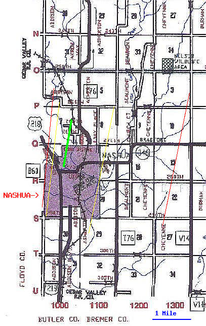
Significant damage to the town of Nashua was sustained on June 18th (see map). The most significant damage occurred in a 2 mile wide by 3 mile long area aligned from southwest to northeast (within yellow lines), centered on the town of Nashua. This damage region was outlined by a 1 mile perimeter of a bit more sporadic damage, with another one mile perimeter area having sporadic damage (within red lined area). Beyond this region of 4 miles by 5 miles, only isolated tree damage occurred through the remainder of Chickasaw county.

- Damage was from straight line winds estimated at 100-120 mph. For the main 2 mile by 3 mile damage swath:
- 95% of the trees downed or toppled were laying from southwest to northeast. This indicates downburst winds along the same orientation. Only a few trees in the park (beginning of green line) in the center of Nashua had an orientation 30 degrees from this main southwest to northeast alignment. All others were southwest-northeast. About half of the trees in the damage swath were pushed over and very few were snapped off at the base - usually showing substantial rot on the interior. Soil was also very moist.
- Large structures, for the most part, were undamaged except for debris damage on the outside. Structures surrounding the park had only minor damage from airborne debris (aerials down, shingles missing, siding off) considering the major trees down. The worst hit structure was a small home on the leeward side of the lake, north of the town park (northern end of green line). Again, this damage appeared to be straight-line as debris was blown from southwest to northeast.
- No trees were twisted in any manor or debarked. No vehicles were moved.
- The calf-high corn in the fields southwest of Nashua was all lying 30 degrees from vertical towards the northeast with no scour marks found to the field.
- 98% of all damage was oriented southwest to northeast.
- Eye Witness account from southwest of Nashua: (paraphrase). "There was a lowering of the clouds looking like a funnel about 150-200 feet off the ground. But it never touched the ground when I was watching it. It just stayed above the surface." This confirms the idea that no tornado actually touched down however does give reasoning of the mesocyclone being just off the surface.
- Information from the WSR-88D La Crosse Radar:
- Radar depicted the storm moving into southwestern Chickasaw county at 2015Z. The velocity image is quite interesting with the center of rotation west of Nashua. This places the strongest southwest to northeast winds (green pixel area between yellow lines) right over Nashua. Taking 50 mph velocities (in a storm relative framework) and adding the storm speed of 40 mph indicates 90 mph velocities are present in a ground relative framework. Again, this is at 10,000 feet.
- So, the storm was rotating cyclonically quite rapidly. Previous volume scans showed little rotation that was organized and the first algorithm detected mesocyclone off the radar was at the end of the 2015Z volume scan at about 2020Z.
Bottom Line: Nashua was hit with a rapidly evolving downburst wind approximately 100-120 mph in strength. This was well supported by radar and ground damage.
