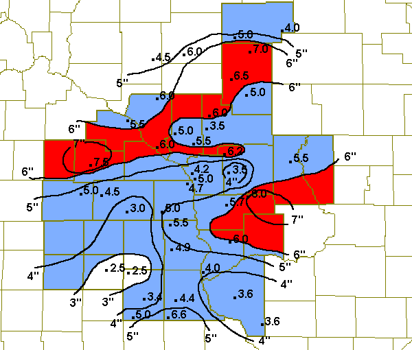
January 30-31, 2002 Snow Totals
A double barreled low pressure system brought two rounds of snow to the region to wrap up the month of January. A strong upper level low pressure system moved across the Rocky mountains into Kansas January 29th. A stationary cold front was sitting from the Ohio River valley into the Texas panhandle. An upper air disturbance created by the strong upper level low move northeast across the Midwest January 30th. This caused low pressure at the surface to move northeast along the front and help spread snow into the area. This was the first round of snow, with 1 to 2 inch accumulations mainly south of Interstate 90. The second round of snow developed on the 31st as the upper level low moved northeast from Kansas, across Iowa into northern Illinois. A second low formed at the surface and also moved northeast along the stationary front. Short periods of heavy snow formed and dumped from five to seven inches of snow in isolated locations of southeast Minnesota and southwest Wisconsin. The rest of the region generally saw snowfall amounts in the two to five inch range. The map below is an estimate of the snowfall totals for both rounds of snow.

Snow totals for January 30th and 31st.
ZCZC MKEPNSLSE
ABUS34 KLSE 011448

PUBLIC INFORMATION STATEMENT
NATIONAL WEATHER SERVICE LA CROSSE WI
832 AM CST FRI FEB 01 2002

24 HOUR SNOWFALL TOTALS ACROSS THE AREA

LOCATION                   COUNTY              SNOWFALL

...IOWA...
DORCHESTER (COOP)          ALLAMAKEE              5.0
ELKADER 5 SSW              CLAYTON                4.4
FAYETTE                    FAYETTE                3.4
NEW HAMPTON                CHICKASAW              2.0
OLWEIN                     FAYETTE                4.0
STRAWBERRY POINT           CLAYTON                4.2
WAUCOMA                    FAYETTE                2.0
WAUKON                     ALLAMAKEE              4.1

...MINNESOTA...
GRAND MEADOW               MOWER                  5.0
HARMONY                    FILLMORE               3.0
LA CRESCENT 1N (UCOOP)     HOUSTON                3.9
ROCHESTER AP 2NE           OLMSTED                7.5
SPRING GROVE               HOUSTON                4.5
SPRING VALLEY              FILLMORE               4.5
WABASHA                    WABASHA                5.5

...WISCONSIN...

ARCADIA                    TREMPEALEAU            5.0
CUBA CITY 2NW              GRANT                  1.6
CHIPPEWA FALLS (UCOOP)     CHIPPEWA               6.0
ELK MOUND (UCOOP)          DUNN                   4.5
ETTRICK 5 SE (UCOOP)       TREMPEALEAU            5.0
FOUR CORNERS (UCOOP)       MONROE                 5.2
FOUNTAIN CITY              BUFFALO                6.0
GAD (UCOOP)                TAYLOR                 4.0
GAYS MILLS                 CRAWFORD               5.0
HIXTON 5 W (UCOOP)         JACKSON                6.0
HOLMEN 2 S (UCOOP)         LA CROSSE              3.5
ISLAND LAKE (UCOOP)        RUSK                   6.7
LA CROSSE STATE RD COULEE  LA CROSSE              4.0
LA CROSSE WFO              LA CROSSE              4.2
LANCASTER 4 WSW            GRANT                  1.9
LUBLIN                     TAYLOR                 5.0
MONDOVI 6 S                BUFFALO                6.0
NECEDAH                    JUNEAU                 5.5
NEILLSVILLE                CLARK                  5.0
ONTARIO                    VERNON                 7.0
OWEN 3W                    CLARK                  7.0
PRAIRIE DU CHIEN           CRAWFORD               2.9
SPARTA                     MONROE                 3.0
TAYLOR (UCOOP)             JACKSON                5.5
WESTBY 1NE                 VERNON                 5.0
WILLARD                    CLARK                  6.5

$$

SAW
NNNN
ZCZC MKEPNSLSE
ABUS34 KLSE 311440

PUBLIC INFORMATION STATEMENT
NATIONAL WEATHER SERVICE LA CROSSE WI
840 AM CST THU JAN 31 2002

 24 HOUR SNOWFALL TOTALS ACROSS THE AREA

LOCATION                   COUNTY              SNOWFALL

...IOWA...
CRESCO 1 NE                HOWARD                 0.6
DORCHESTER (COOP)          ALLAMAKEE              0.5
FAYETTE                    FAYETTE                1.0
NEW HAMPTON                CHICKASAW              0.5
OELWEIN                     FAYETTE               1.0
OSAGE                      MITCHELL               0.8
STRAWBERRY POINT           CLAYTON                2.4
WAUCOMA                    FAYETTE                0.5
WAUKON                     ALLAMAKEE              0.8


...MINNESOTA...

BYRON                      OLMSTED                  T
LA CRESCENT 1N (UCOOP)     HOUSTON                0.8
ROCHESTER AP 2NE           OLMSTED                  T
SPRING GROVE               HOUSTON                0.5

...WISCONSIN...
BLACK RIVER FALLS SEWAGE   JACKSON                0.5
CUBA CITY 2NW              GRANT                  2.0
ETTRICK 5 SE (UCOOP)       TREMPEALEAU            0.5
FOUR CORNERS (UCOOP)       MONROE                 1.0
FRIENDSHIP 1E              ADAMS                  1.0
GAYS MILLS                 CRAWFORD               1.0
HILLSBORO                  VERNON                 1.0
HOLMEN 2 S (UCOOP)         LA CROSSE              0.7
LA CROSSE WFO              LA CROSSE              0.8
LANCASTER 4 WSW            GRANT                  1.7
NEILLSVILLE                CLARK                    T
ONTARIO                    VERNON                 1.0
PRAIRIE DU CHIEN           CRAWFORD               1.1
PLATTEVILLE                GRANT                  1.7
READSTOWN                  VERNON                 1.2
SPARTA                     MONROE                 0.5
WESTBY 1NE                 VERNON                 0.7

$$


Additional totals received through our web site:
| Location | County | Snowfall |
| Necedah 2 south | Juneau | 6.0" |
| Le Roy | Mower | 4.5" |