| From the late afternoon of January 26, 1996 until the morning of the 27th, areas of southwest Wisconsin, northeast Iowa, and southeast Minnesota were hit by a blizzard of historic proportions. This monstrous winter storm developed over the Texas Panhandle and moved northeast into southeast Iowa by the early afternoon hours of the 26th (Fig. 1).
With the passage of a cold front a day earlier, as well as strong dynamics in place with the low, an extensive area of overrunning snow broke out across southeast Iowa during the early afternoon. Meanwhile, thunderstorms developed over central Iowa near Des Moines, producing large hail and winds greater than 60 mph. On the cold side of the storm, northwest of the surface low, snowfall rates of 3 inches per hour with thunder and lightning were reported. Combined with north winds of 30 to 40 mph, whiteout conditions were created across the state of Iowa. A state of emergency was declared by the governor of Iowa, and some claimed the storm to be the worst to hit the state in twenty years. |
|
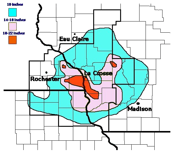
The storm continued to intensify as it moved northeast during the afternoon, dropping significant snow amounts across northeast Iowa. As the snow spread into southern and southwest Wisconsin, it became convective, adding lightning and thunder to the snowfall. Reports of snowfall rates of 3-4" per hour were common. Schools and businesses closed early on the 26th, and even snow plows were pulled off the road by early in the evening. Snowfall totals of 10-13" were common (Fig. 2), with an isolated report of 18" six miles east of La Crosse, WI (Table 1). Drifts of 4-8' made travel nearly impossible.
 |
| Fig 2. Map of approximate snow totals. |
|
Iowa |
|
|
Dorchester |
16.5" |
|
Waukon |
16.0" |
|
Postville |
15.0" |
|
Lansing |
13.3" |
|
Charles City |
12.3" |
|
Decorah |
12.0" |
|
Mason City |
11.0" |
|
Minnesota |
|
|
Spring Grove |
19.0" |
|
Lanesboro |
18.0" |
|
Preston |
15.0" |
|
Byron |
14.5" |
|
Winona |
12.0" |
|
Caledonia |
11.0" |
|
Wisconsin |
|
|
Viroqua |
15.0" |
|
Sparta |
14.0" |
|
Richland Center |
16.0" |
|
La Crosse Airport |
13.0" |
|
Cashton |
12.0" |
Table 1. Some snowfall totals from January 26-27, 1996. |
|