A potent winter storm made a "white" Christmas a foregone conclusion as it brought accumulations of a foot or more to some locations across the Upper Mississippi River Valley. After starting out as some drizzle or light rain, the precipitation changed over to snow Saturday afternoon the 22nd, and then continued to fall through the better part of Sunday the 23rd. Snowfall rates Saturday night of an inch per hour were common at times. In addition to the snow, the winds started to increase Saturday night, becoming very blustery on Sunday. Northwest winds of 20 to 30 mph with gusts of 40 to 45 mph led to blowing and drifting of the falling, and fallen snow. "White-out" conditions (snow and wind leading to near zero visibilities) developed in many areas as a result, with snow drifts of several feet also being reported. Travel was impossible in some areas Saturday night and early Sunday, especially in rural, unsheltered areas.
Discussion about a potential winter storm for the holiday weekend leading up to Christmas began nearly a week in advance. A trough of low pressure in the upper atmosphere was expected to slide across the Rockies, with an area of low pressure at the surface developing over the Southern Plains/Texas in response to this trough. The system would then strengthen as it moved northeast across the Great Lakes, leading to areas of snow for the local area...potentially a lot of snow. While the forecast models used to aid the forecasters varied in where the biggest impact of the storm would be, confidence was high that the region would get some snow. How much, however, was uncertain.
As Saturday approached, however, confidence increased in the track of the storm system. Winter Storm Watches were issued on Thursday the 20th for parts of the region, which were upgraded to Winter Storm Warnings or Snow and Blowing Snow Advisories on Friday.
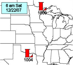
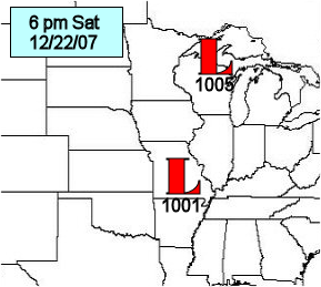
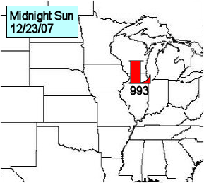
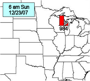
As the low pressure system to the south started to swing northeast out of the Southern Plains, a different disturbance in the upper atmosphere was dropping south out of Canada. These two systems merged across the Upper Mississippi River Valley Saturday night, with the low pressure system adding the energy of the disturbance, and significantly increasing its overall strength (and slowing it down). At the surface, a low was located over Texas Saturday morning, while another low was located over the arrowhead of Minnesota. By 6 pm Saturday, the southern low had moved into southern Missouri, while the northern low drifted across northern Wisconsin. The northern system now started to merge with the stronger one moving up from the south, with a rapidly deepening low over northern Illinois by midnight. The storm system continued to deepen (become stronger) as it moved over northeast Wisconsin by Sunday morning. The low then sat nearly stationary through Sunday before finally drifting east Sunday night.
 |
 |
 |
 |
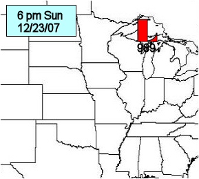 |
| 6 am Saturday | 6 pm Saturday | Midnight Sunday | 6 am Sunday | 6 pm Sunday |
The track of the storm system resulted in the heaviest snows falling across western Wisconsin, with totals of a foot or more in some locations. As you moved west, totals quickly dropped off, with 2 inches or less being recorded along and west of a Rochester, MN to New Hampton, IA line.
In addition to the snow, there was some drizzle and freezing drizzle before the heart of the storm system moved in Saturday afternoon and evening. The bulk of this was over portions of northeast Iowa and southwest Wisconsin, although most locations saw at least some patchy drizzle (or freezing drizzle) Saturday morning and early afternoon.
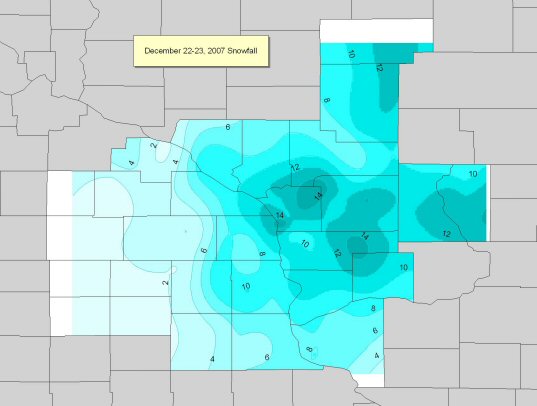
PUBLIC INFORMATION STATEMENT
NATIONAL WEATHER SERVICE LA CROSSE WI
1114 AM CST MON DEC 24 2007

...DECEMBER 22ND AND 23RD STORM SNOWFALL TOTALS ACROSS THE AREA...

LOCATION COUNTY SNOWFALL

...NORTHEAST IOWA...


LANSING 4SE ALLAMAKEE 10.9
WAUKON ALLAMAKEE 10.0
DECORAH 8ENE WINNESHIEK 9.5
WATERVILLE ALLAMAKEE 8.0
MARQUETTE 3W CLAYTON 7.0
EDGEWOOD CLAYTON 6.5
DORCHESTER ALLAMAKEE 6.3
VOLGA 1NE CLAYTON 6.0
NEW HAMPTON CHICKASAW 6.0
CLERMONT FAYETTE 5.0
ELKADER 6SSW CLAYTON 4.8
OELWEIN 1E FAYETTE 3.2
FAYETTE FAYETTE 3.1
CRESCO 1NE HOWARD 2.0
KENDALLVILLE WINNESHIEK 2.0
ELMA HOWARD 0.8
CHARLES CITY FLOYD 0.5

 ...SOUTHEAST MINNESOTA...

 RENO 3SW HOUSTON 9.3
WINONA DAM 5A WINONA 9.0
SPRING GROVE HOUSTON 8.3
CALEDONIA HOUSTON 6.6
ZUMBRO FALLS WABASHA 5.0
ALTURA 5W WINONA 4.2
ELGIN 2SSW WABASHA 3.3
PRESTON FILLMORE 3.3
WABASHA WABASHA 2.5
ORONOCO OLMSTED 2.1
LANESBORO FILLMORE 2.0
DODGE CENTER DODGE 2.0
THEILMAN WABASHA 1.8
GRAND MEADOW MOWER 1.5
ROCHESTER AIRPORT 2NE OLMSTED 1.1


 ...SOUTHWEST AND CENTRAL WISCONSIN...

 LA CROSSE 4SE LA CROSSE 14.8
FOUR CORNERS LA CROSSE 14.7
LA FARGE VERNON 14.6
LA CROSSE 5SE LA CROSSE 14.5
WEST SALEM LA CROSSE 14.0
TUNNEL CITY 1S MONROE 13.7
MEDFORD TAYLOR 13.5
FRIENDSHIP 10NE ADAMS 13.0
LA CROSSE WFO LA CROSSE 12.8
MEDFORD 4NW TAYLOR 12.8
WESTBY 3ENE VERNON 12.6
ARKDALE ADAMS 12.5
FRIENDSHIP ADAMS 12.5
GALESVILLE 2E TREMPEALEAU 12.0
WILTON 3E MONROE 12.0
NECEDAH 2SE JUNEAU 11.8
HOLMEN 2S LA CROSSE 11.8
HILLSBORO VERNON 11.5
SPARTA MONROE 11.3
GOODRICH TAYLOR 11.0
VIROQUA VERNON 10.7
OWEN CLARK 10.6
GAYS MILLS CRAWFORD 10.5
CHASEBURG 2S VERNON 10.5
STODDARD 3NE VERNON 10.4
RICHLAND CENTER RICHLAND 10.1
BIG FLATS ADAMS 10.0
NEILLSVILLE CLARK 10.0
WARRENS 5WSW MONROE 10.0
COON VALLEY VERNON 9.8
TAYLOR JACKSON 9.5
BLACK RIVER FALLS JACKSON 9.5
DESOTO 3N VERNON 9.5
POTOSI GRANT 9.0
BUFFALO CITY BUFFALO 9.0
CASSVILLE GRANT 8.0
STEUBEN 4SE GRANT 8.0
WHITEHALL TREMPEALEAU 8.0
INDEPENDENCE TREMPEALEAU 8.0
OSSEO TREMPEALEAU 7.7
LANCASTER GRANT 7.0
HATFIELD JACKSON 6.1
PLATTEVILLE GRANT 4.4
CUBA CITY GRANT 3.4

OBSERVATIONS ARE COLLECTED FROM A VARIETY OF SOURCES WITH VARYING
EQUIPMENT AND EXPOSURE. NOT ALL DATA LISTED IS CONSIDERED OFFICIAL.
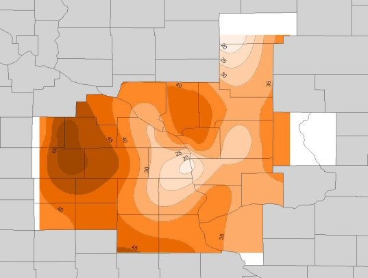
PUBLIC INFORMATION STATEMENT
NATIONAL WEATHER SERVICE LA CROSSE WI
115 PM CST MON DEC 24 2007

 ...HIGHEST SUSTAINED WIND SPEEDS AND GUSTS FOR SUNDAY DECEMBER 23RD...

 STATION COUNTY TIME SPEED GUST

DEXTER RWIS MOWER 336 PM 41 MPH 52 MPH
BYRON/KASSON RWIS DODGE 344 PM 36 MPH 51 MPH
ROCHESTER ASOS OLMSTED 446 PM 31 MPH 49 MPH
PRESTON AWOS FILLMORE 315 PM 26 MPH 46 MPH
OELWEIN AWOS FAYETTE 455 PM 31 MPH 45 MPH
ARCADIA HILL RWIS TREMPEALEAU 1210 PM 21 MPH 41 MPH
DODGE CENTER AWOS DODGE 315 PM 31 MPH 41 MPH
CHARLES CITY AWOS FLOYD 155 PM 33 MPH 40 MPH
MOUNT STERLING 1S RWIS CRAWFORD 808 PM 22 MPH 39 MPH
AUSTIN AWOS MOWER 236 PM 26 MPH 39 MPH
PRAIRIE DU CHIEN AWOS CRAWFORD 255 AM 21 MPH 38 MPH
VOLK FIELD JUNEAU 421 PM 25 MPH 38 MPH
NECEDAH JUNEAU 148 PM 21 MPH 37 MPH
3N LA CRESCENT APRS HOUSTON 334 PM 10 MPH 35 MPH
TOMAH 4N RWIS MONROE 607 AM 17 MPH 35 MPH
DECORAH AWOS WINNESHIEK 215 PM 15 MPH 33 MPH
BOSCOBEL ASOS GRANT 1153 AM 20 MPH 33 MPH
MEDFORD AWOS TAYLOR 355 PM 22 MPH 33 MPH
LA CROSSE ASOS LA CROSSE 337 PM 21 MPH 33 MPH
PDC RWIS MISS RIVER CRAWFORD 207 PM 18 MPH 31 MPH
WINONA AWOS WINONA 555 PM 21 MPH 30 MPH
JACKSON PASS 5W TOMAH MONROE 409 PM M 28 MPH
SPARTA AWOS MONROE 535 PM 20 MPH 28 MPH
LA CROSSE 1S APRS LA CROSSE 626 PM 13 MPH 24 MPH
MAUSTON APRS JUNEAU 345 PM 13 MPH 23 MPH
DICKEYVILLE RWIS GRANT 903 PM 13 MPH 22 MPH
DIAMOND LAKE RAWS TAYLOR 114 AM 10 MPH 16 MPH


KEY TO OBSERVATION TYPES
AWS - SENSORS FROM AWS INCORPORATED. OFTEN LOCATED AT SCHOOLS.
RWIS - ROAD WEATHER INFORMATION SYSTEMS. LOCATED ON MAJOR ROADS AND BRIDGES.
RAWS - FIRE WEATHER OBSERVATIONS. OFTEN LOCATED IN FORESTS.
ASOS/AWOS - AVIATION WEATHER OBSERVATIONS. LOCATED AT AIRPORTS.

OBSERVATIONS ARE COLLECTED FROM A VARIETY OF SOURCES WITH VARYING EQUIPMENT
AND EXPOSURE. NOT ALL DATA LISTED IS CONSIDERED OFFICIAL.