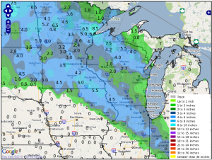
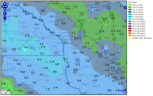
Snowfall Totals For December 20-21, 2010
| Snowfall Maps | Snowfall Reports |
A low pressure area moved east out of the Rockies Sunday night the 19th, pushing into the Plains Monday evening (the 20th). Snow spread well ahead of the system, reaching from the eastern Dakotas into parts of northern Illinois by Monday morning, and western Wisconsin by the afternoon. The snow was moderate to heavy at times, reducing visibilities to 1/2 mile or less with hourly snowfall rates near 1 inch. The heaviest snows fell from late afternoon into early evening on Monday, December 20th.
The snow exited into eastern Wisconsin by mid evening on Monday, but behind the snow areas of freezing drizzle brought some additional thin glazing of ice.
 |
Media use of NWS Web News Stories is encouraged. Please acknowledge the NWS as the source of any news information accessed from this site.
|
 |
 |
| Regional Map of 24 hour snowfall totals ending at 8 a.m. December 21, 2010. | Local Map of 24 hour snowfall totals ending at 8 a.m. December 21, 2010. |
Snowfall Totals
PUBLIC INFORMATION STATEMENT
NATIONAL WEATHER SERVICE LA CROSSE WI
1039 AM CST TUE DEC 21 2010

...STORM TOTAL SNOWFALL FOR DECEMBER 20TH...

LOCATION		      SNOWFALL	  TIME    LAT/LON

NORTHEAST IOWA

...ALLAMAKEE COUNTY...
WAUKON                        7.0         0642 AM 43.27N 91.48W
POSTVILLE                     6.6         1029 AM 43.08N 91.57W

...CHICKASAW COUNTY...
IONIA                         5.5         0949 AM 43.04N 92.46W
NEW HAMPTON                   3.2         0827 AM 43.06N 92.32W

...CLAYTON COUNTY...
MARQUETTE 3W                  5.0         0642 AM 43.04N 91.22W
ELKADER 6SSW                  4.9         0904 AM 42.81N 91.43W
VOLGA                         4.8         0712 AM 42.80N 91.54W
GUTTENBERG 1E                 4.5         0717 AM 42.79N 91.09W
CLAYTON CENTER                4.0         0643 AM 42.88N 91.32W

...FAYETTE COUNTY...
FAYETTE                       4.6         0725 AM 42.84N 91.8W

...FLOYD COUNTY...
CHARLES CITY                  4.3         0903 AM 43.07N 92.68W

...HOWARD COUNTY...
CRESCO 1NE                    5.5         0852 AM 43.38N 92.11W
ELMA                          4.2         0956 AM 43.25N 92.44W

...MITCHELL COUNTY...
ST. ANSGAR                    5.2         0728 AM 43.38N 92.92W
OSAGE                         4.2         0746 AM 43.28N 92.81W

SOUTHEAST MINNESOTA

...FILLMORE COUNTY...
HARMONY                       7.5         0957 AM 43.56N 92.01W
LANESBORO                     5.8         0827 AM 43.72N 91.97W

...HOUSTON COUNTY...
LA CRESCENT 2N                5.0         0718 AM 43.85N 91.3W
LA CRESCENT 1N                4.5         0815 AM 43.84N 91.3W

...MOWER COUNTY...
AUSTIN                        5.5         0731 AM 43.67N 92.97W

...OLMSTED COUNTY...
ROCHESTER AIRPORT             6.1         0707 AM 43.91N 92.5W
BYRON                         4.4         0730 AM 44.03N 92.65W

...WABASHA COUNTY...
OAK CENTER                    6.0         0809 AM 44.35N 92.4W
THEILMAN                      4.4         0820 AM 44.30N 92.2W
WABASHA                       4.1         0731 AM 44.37N 92.05W

...WINONA COUNTY...
ALTURA 5W                     4.5         0819 AM 44.07N 92W
WINONA 4SW                    4.0         0654 AM 44.02N 91.69W
MINNESOTA CITY 4E             4.0         0703 AM 44.09N 91.7W
WINONA                        3.0         0724 AM 44.05N 91.66W

SOUTHWEST AND CENTRAL WISCONSIN

...ADAMS COUNTY...
FRIENDSHIP                    1.8         0839 AM 43.97N 89.82W
ARKDALE                       1.6         0748 AM 44.03N 89.88W

...BUFFALO COUNTY...
MONDOVI 6S                    4.0         0812 AM 44.52N 91.67W
ALMA                          3.5         0718 AM 44.33N 91.92W

...CLARK COUNTY...
NEILLSVILLE 3SW               2.0         0709 AM 44.54N 90.62W

...CRAWFORD COUNTY...
PRAIRIE DU CHIEN              5.2         0715 AM 43.04N 91.14W
LYNXVILLE 3S                  5.0         0721 AM 43.22N 91.05W
STEUBEN 4SE                   3.0         0728 AM 43.16N 90.82W

...GRANT COUNTY...
SINSINAWA                     5.5         0900 AM 42.52N 90.53W
LANCASTER                     5.2         0841 AM 42.85N 90.71W
UNION                         4.2         0953 AM 42.83N 90.52W
CUBA CITY                     3.4         0810 AM 42.60N 90.43W

...JACKSON COUNTY...
TAYLOR                        3.0         0701 AM 44.32N 91.12W
BLACK RIVER FALLS             2.1         0828 AM 44.30N 90.85W

...JUNEAU COUNTY...
NECEDAH 3SE                   2.3         0739 AM 44.01N 90.05W
NEW LISBON 2N                 2.0         0700 AM 43.90N 90.17W

...LA CROSSE COUNTY...
LA CROSSE 4NNW                4.9         0830 AM 43.86N 91.25W
LA CROSSE 5SE                 4.5         0643 AM 43.80N 91.19W
HOLMEN 2NW                    4.1         0759 AM 43.98N 91.29W
LA CROSSE AIRPORT (LSE)       4.0         0824 AM 43.87N 91.26W
LA CROSSE NWS                 4.0         0705 AM 43.28N 91.19W
HOLMEN 2S                     3.4         0707 AM 43.95N 91.26W

...MONROE COUNTY...
SPARTA 4S                     5.0         0745 AM 43.91N 90.81W
WARRENS 5WSW                  3.8         0714 AM 44.11N 90.56W
TUNNEL CITY 2S                2.4         0756 AM 43.98N 90.57W
FOUR CORNERS                  2.3         0751 AM 44.08N 90.91W

...RICHLAND COUNTY...
RICHLAND CENTER 1NW           4.5         0727 AM 43.34N 90.39W
RICHLAND CENTER               3.8         0851 AM 43.34N 90.38W

...TAYLOR COUNTY...
MEDFORD                       4.0         0916 AM 45.14N 90.35W
WESTBORO                      4.0         0955 AM 45.35N 90.3W
MEDFORD 4NW                   3.3         0730 AM 45.16N 90.38W

...TREMPEALEAU COUNTY...
TREMPEALEAU                   4.0         0723 AM 44.01N 91.44W
OSSEO                         2.6         0706 AM 44.58N 91.22W
BLAIR 2W                      2.0         0726 AM 44.30N 91.26W

...VERNON COUNTY...
DE SOTO 1SE                   5.9         0644 AM 43.42N 91.19W
STODDARD 5NNE                 4.7         0715 AM 43.72N 91.17W
GENOA                         4.0         0722 AM 43.57N 91.23W
LA FARGE                      3.6         0948 AM 43.58N 90.64W
READSTOWN 4NE                 3.5         0950 AM 43.47N 90.72W
WESTBY 3ENE                   3.2         0803 AM 43.66N 90.82W
VALLEY 1NW                    2.8         0805 AM 43.65N 90.54W
ONTARIO                       2.4         0909 AM 43.72N 90.59W

OBSERVATIONS ARE COLLECTED FROM A VARIETY OF SOURCES WITH VARYING
EQUIPMENT AND EXPOSURE.  NOT ALL DATA LISTED IS CONSIDERED OFFICIAL.