Overview
|
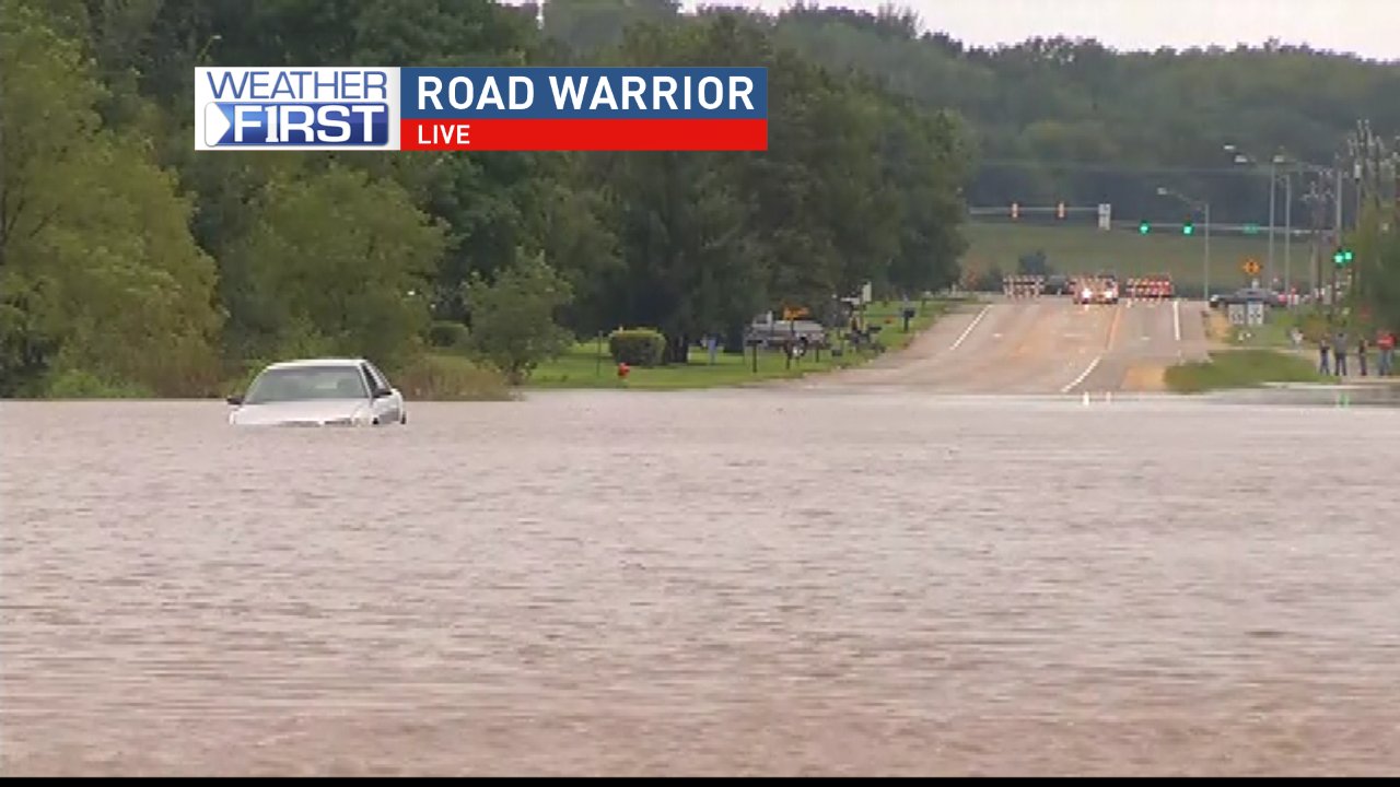
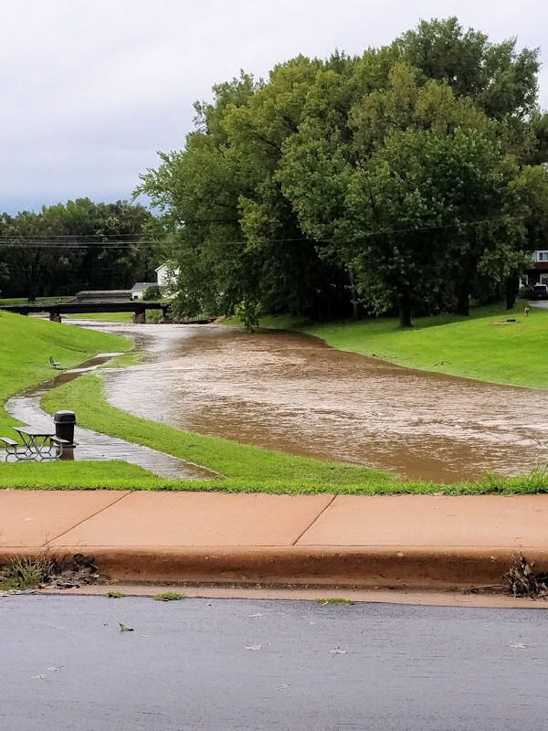
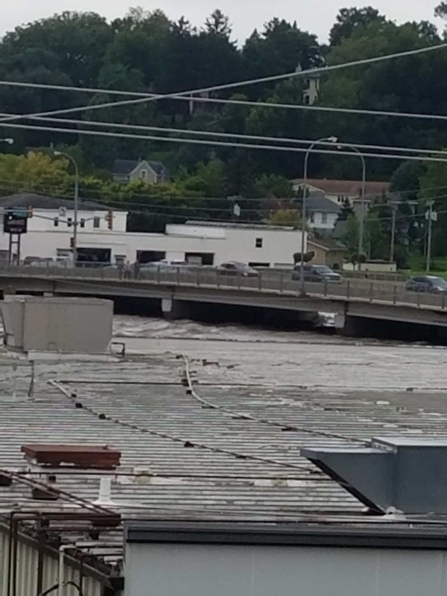
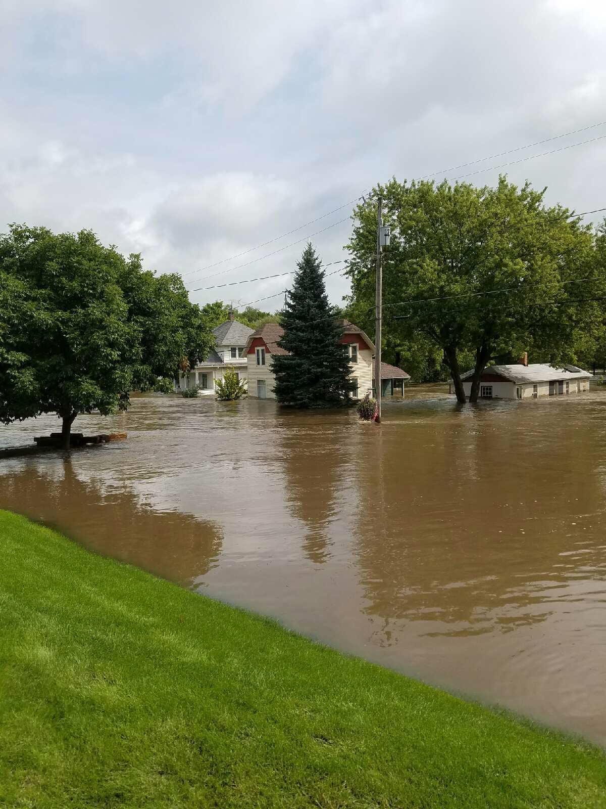
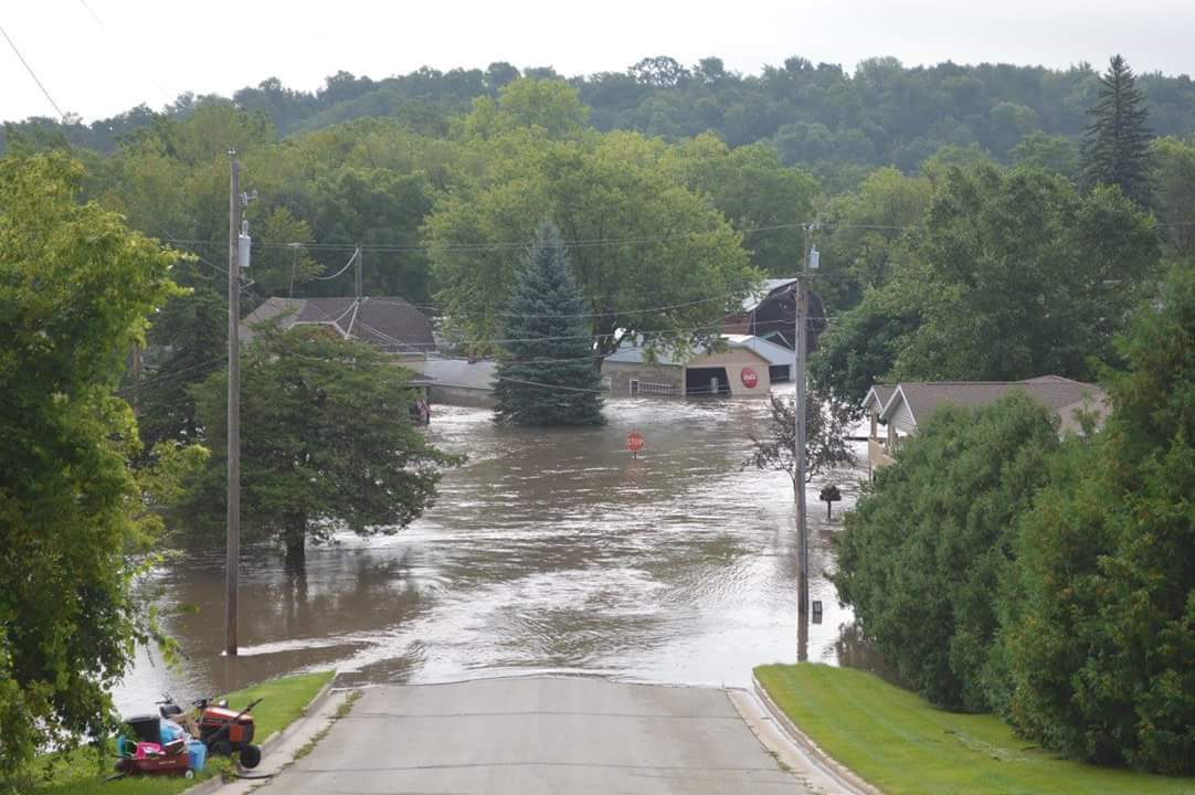
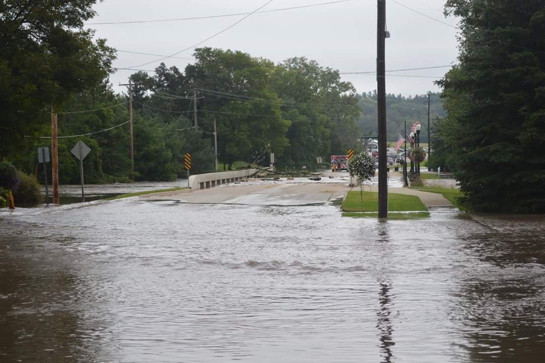
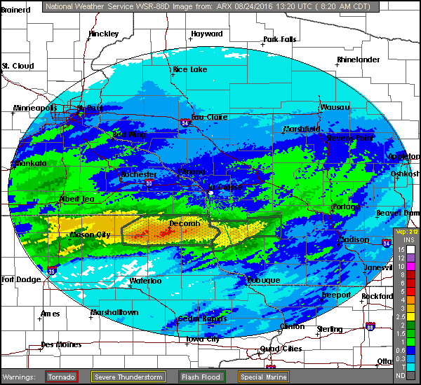
Rounds of thunderstorms with heavy rain tracked over the same areas repeatedly during the evening of Tuesday, August 23rd through the early morning of Wednesday, August 24th. Rainfall accumulated between 5 to 8" across extreme northeast Iowa into southwest Wisconsin. This led to widespread flooding and rapidly rising rivers. One elderly man was killed in rural Chickasaw Co., IA when his car was swept away by flood waters during the early morning hours (4:40 a.m.). There were numerous road closures, water rescues, and homes inundated by flood waters. Rivers impacted included the Cedar, Upper Iowa, and Turkey in northeast Iowa. In southwest Wisconsin, the Kickapoo River had some flooding. Record river crests from this event included:
|
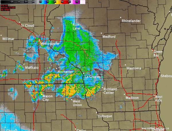 Radar loop from approx. 10 pm Aug.23rd to 4 am Aug.24th |
Flooding
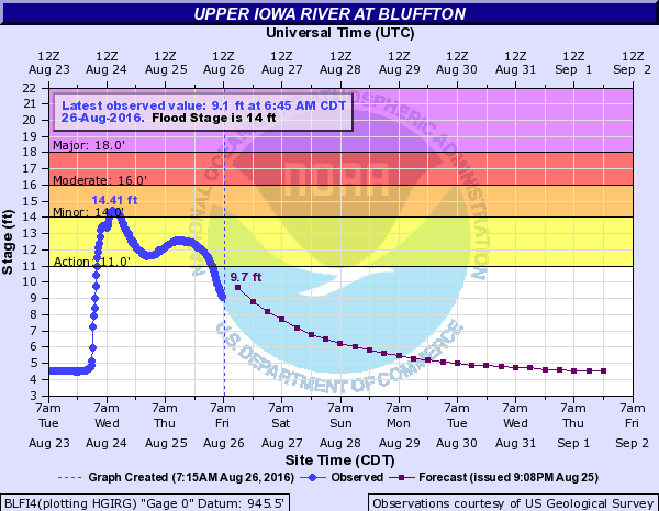
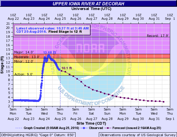
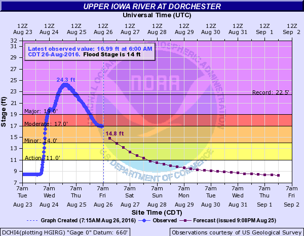
Hydrographs
 |
 |
 |
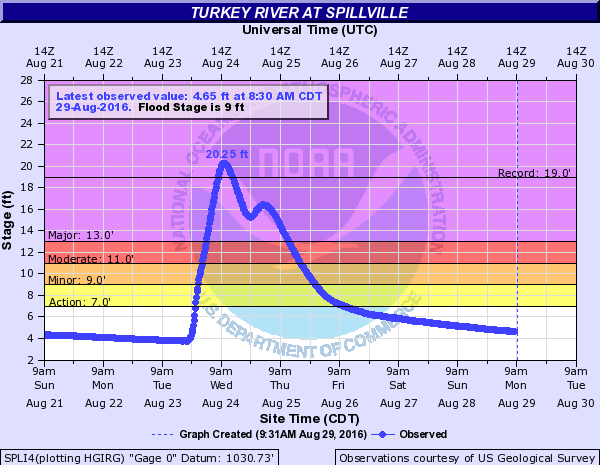 |
| Hydrograph Upper Iowa River @ Bluffton, IA | Hydrograph Upper Iowa River @ Decorah, IA | Hydrograph Upper Iowa River @ Dorchester, IA | Hydrograph Turkey River @ Spillville, IA |
 |
 |
 |
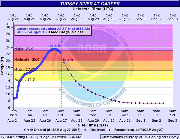 |
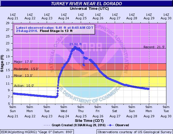
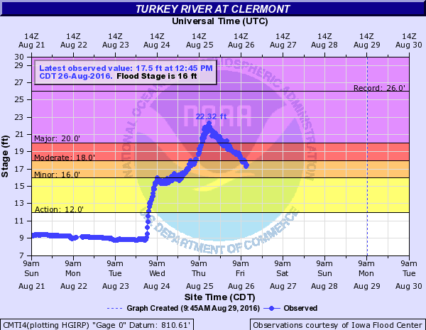
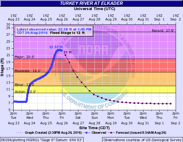
| Hydrograph Turkey River @ Eldorado, IA | Hydrograph Turkey River @ Clermont, IA | Hydrograph Turkey River @ Elkader, IA | Hydrograph Turkey River @ Garber, IA |
 |
 |
 |
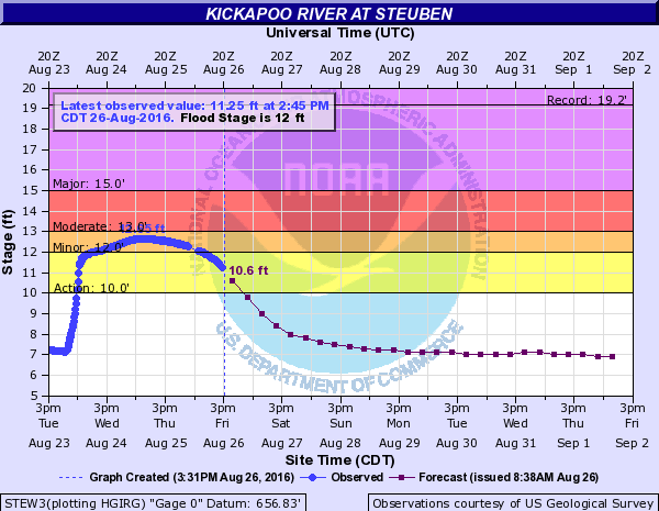 |
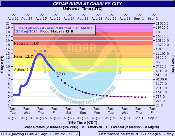
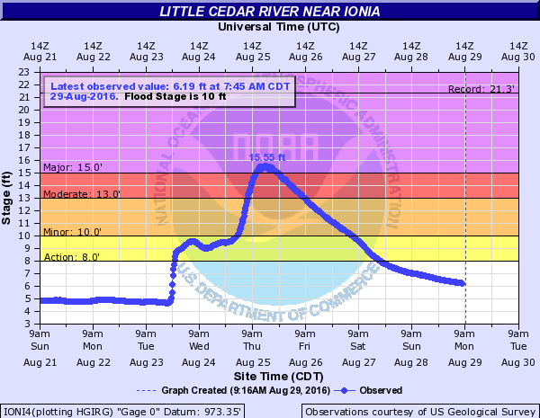
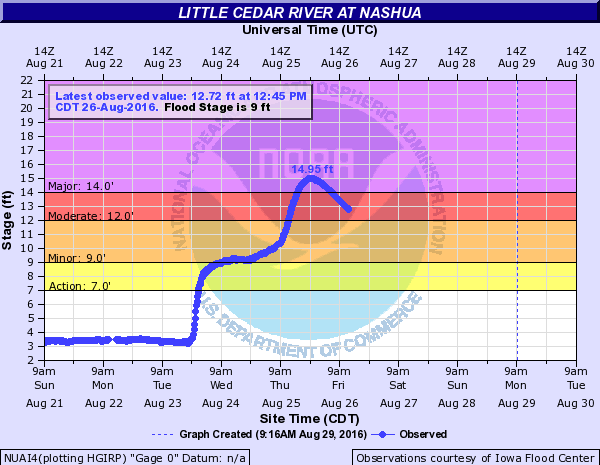
| Hydrograph Cedar River @ Charles City, IA | Hydrograph Little Cedar River near Ionia, IA | Hydrograph Little Cedar River @ Nashua, IA | Hydrograph Kickapoo River @ Steuben, WI |
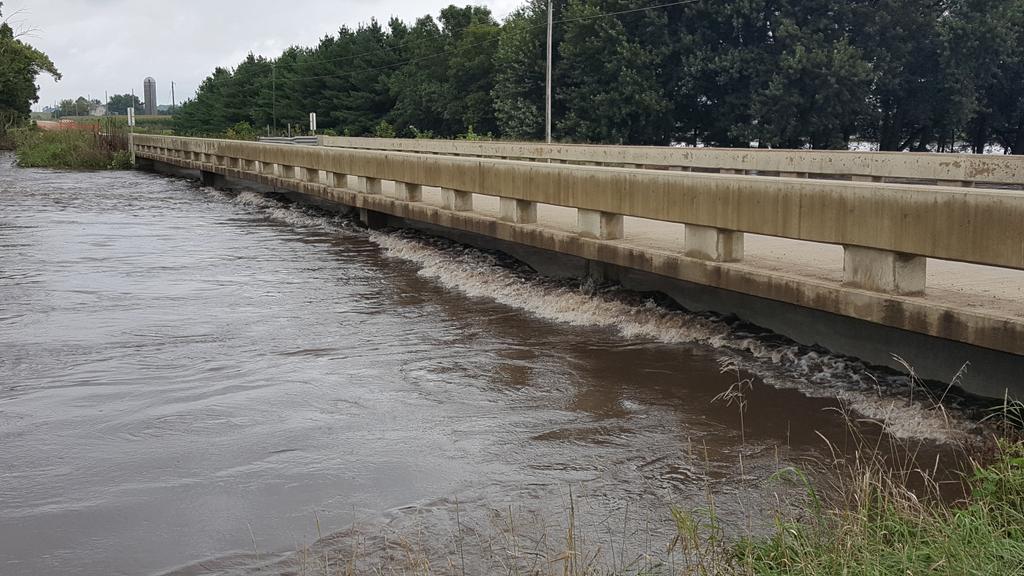
Photos:
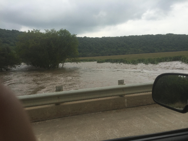
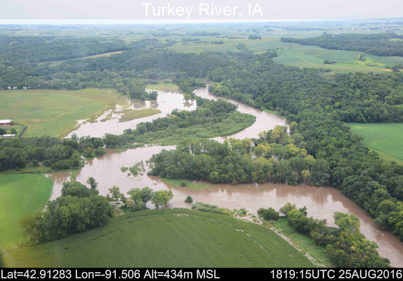
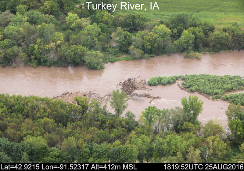
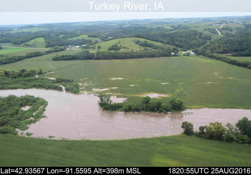
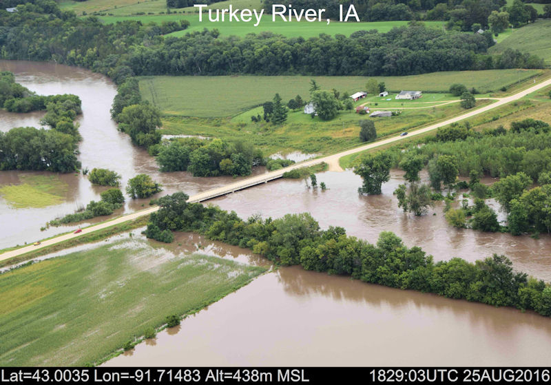
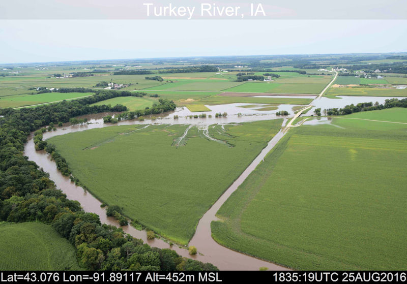
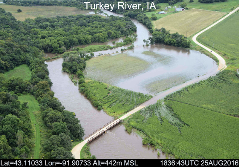
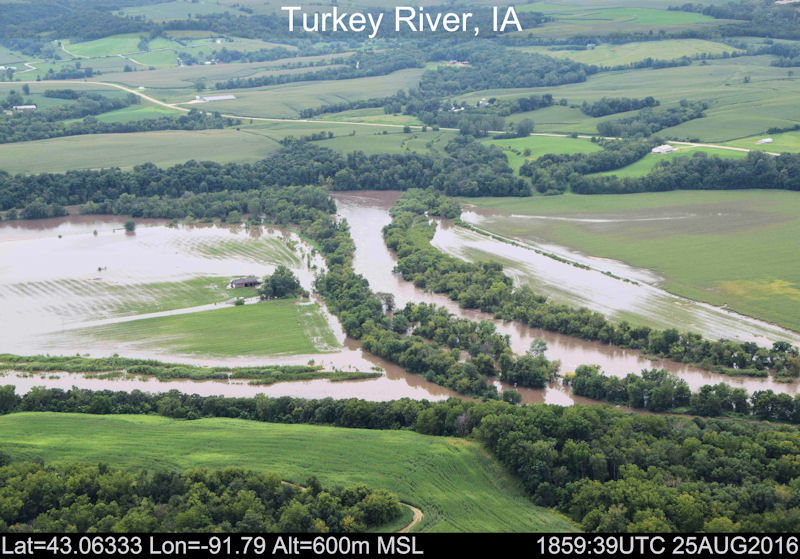
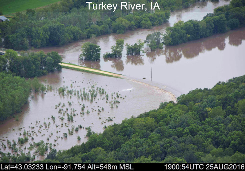
Additonal Aerial Photos of the Turkey River during flood:
 |
 |
 |
 |
| Flooding in Decorah, IA (Photo used with permission by Jason Meyer) |
Flooding in Boscobel, WI (Photo used with permission by Wisc-yeti) |
Before/After Flooding in Decorah, IA (Photos used with permission by Drew Duffy) |
Flooding in Decorah, IA (Photo used with permission by Drew Duffy) |
 |
 |
 |
 |
| Flooding in Spillville, IA (Photo used with permission by Eric Albertson) |
Flooding in Spillville, IA (Photo used with permission by KWWL/Mark Schnackenberg) |
Flooding in Spillville, IA (Photo used with permission by KWWL/Mark Schnackenberg) |
Dam at Gays Mills, WI (Photo used with permission by Lee Mushel) |
 |
 |
 |
 |
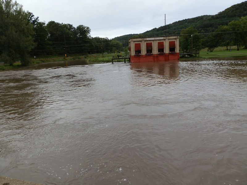
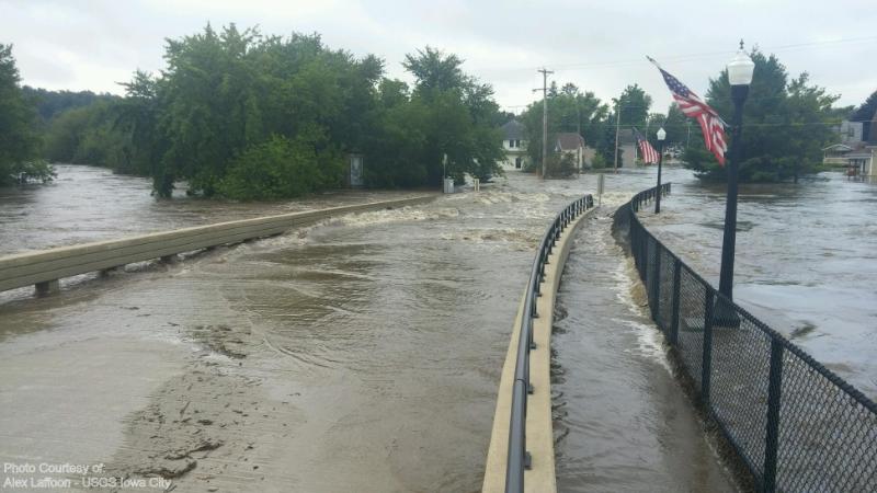
| Flooding in Spillville, IA (Photo used with permission by USGS - Alex Laffoon) |
Flooding along the Yellow River between Waukon and Luana, IA. (Photo used with permission from Mike Johnson) |
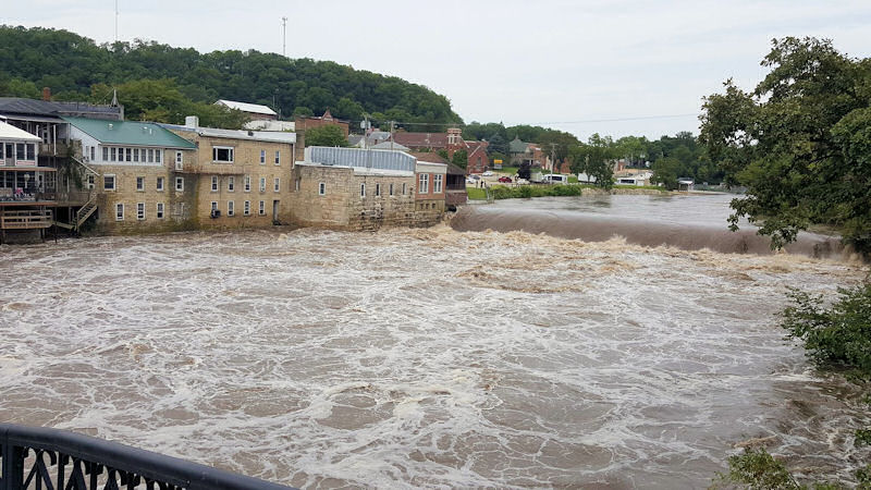
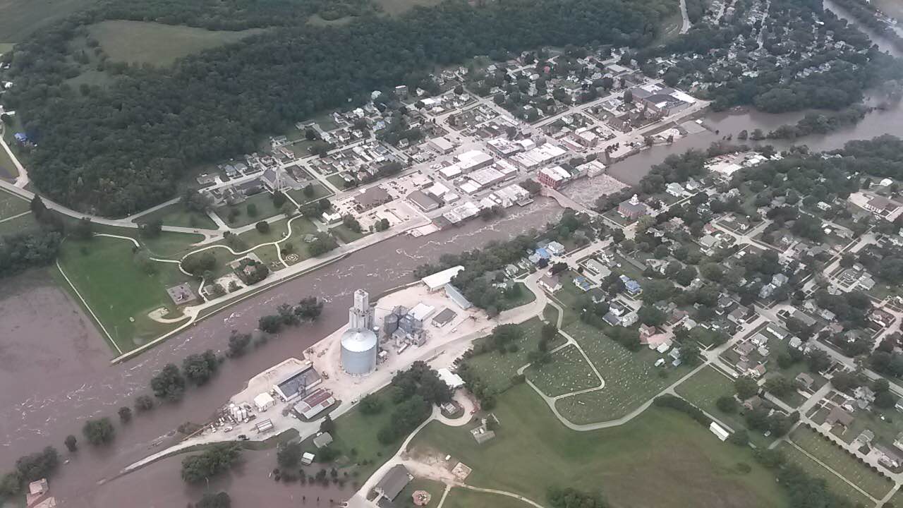
Turkey River in Elkader, IA near crest time. (Photo used with permission by MacLeod Hageman/KWWL) |
Little Turkey River north of Lawler, IA (Photo used with permission by MacLeod Hageman/KWWL) |
 |
 |
 |
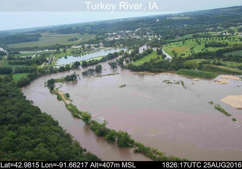 |
| Flooding along Turkey River (Photo used with permission by NOAA / OWP) |
Flooding along Turkey River (Photo used with permission by NOAA / OWP) |
Flooding along Turkey River (Photo used with permission by NOAA / OWP) |
Flooding along Turkey River (Photo used with permission by NOAA / OWP) |
 |
 |
 |
 |
| Flooding along Turkey River (Photo used with permission by NOAA / OWP) |
Flooding along Turkey River (Photo used with permission by NOAA / OWP) |
View of Elkader, IA near crest (Photo used with permission by MacLeod Hageman/KWWL) |
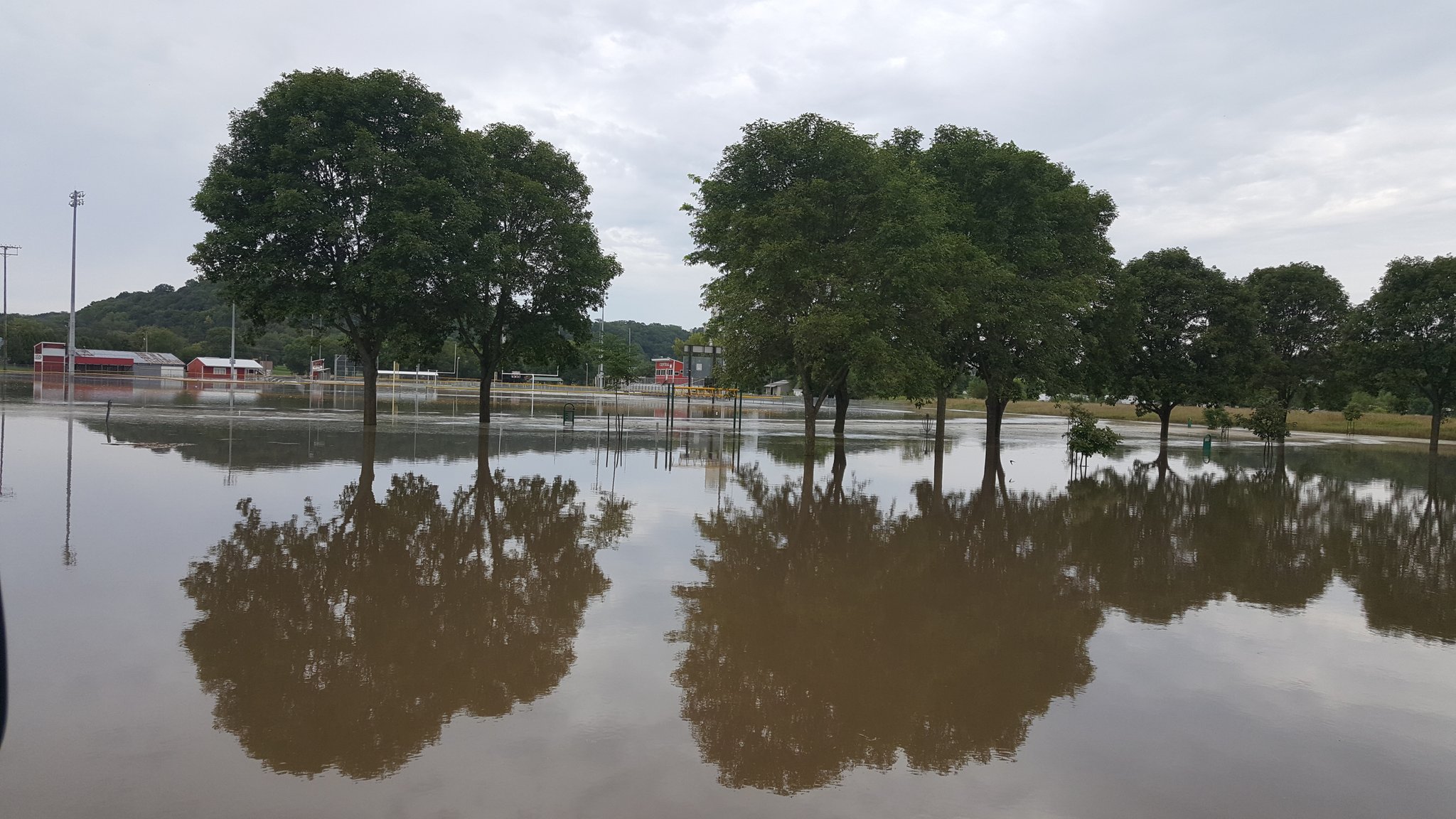
Flooded fields and parks in Elkader, IA (Photo used with permission by MacLeod Hageman/KWWL) |
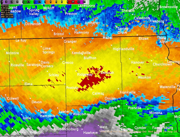
Radar:
Header
 |
 |
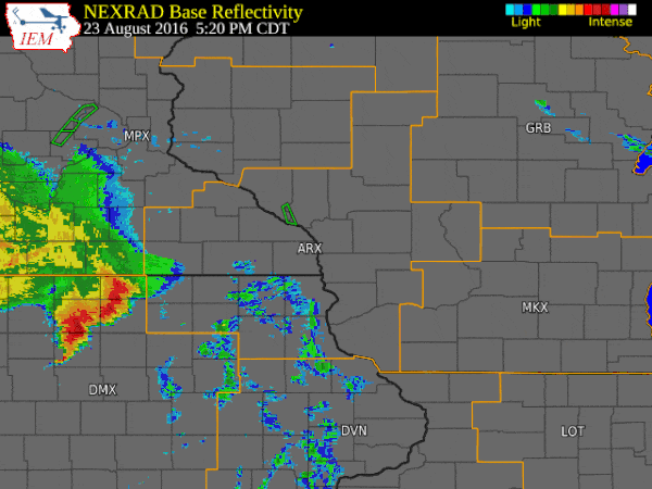 |
| Rainfall estimates off the radar. | Zoomed image of Dual-Pol radar estimates. | Animation from 5:20 pm Aug.23 to 4:20 am Aug.24 with warnings overlaid. (Courtesy of Iowa Environmental Mesonet) |
Storm Reports
PRELIMINARY LOCAL STORM REPORT...SUMMARY
NATIONAL WEATHER SERVICE LA CROSSE WI
815 AM CDT WED AUG 24 2016

..TIME...   ...EVENT...      ...CITY LOCATION...     ...LAT.LON...
..DATE...   ....MAG....      ..COUNTY LOCATION..ST.. ...SOURCE....
            ..REMARKS..

1106 PM     FLOOD            CALMAR                  43.18N 91.87W
08/23/2016                   WINNESHIEK         IA   LAW ENFORCEMENT

            CREEKS STARTING TO OVERFLOW. LOTS OF STREET
            FLOODING IN TOWNS AROUND THE COUNTY.

1125 PM     FLASH FLOOD      CALMAR                  43.18N 91.87W
08/23/2016                   WINNESHIEK         IA   LAW ENFORCEMENT

            REPORTS OF A BASEMENT COLLAPSE FROM RISING
            WATER AROUND COMMUNITY.

1138 PM     FLASH FLOOD      1 S DECORAH             43.29N 91.79W
08/23/2016                   WINNESHIEK         IA   911 CALL CENTER

            WATER FLOODED CAR IN OLD WALMART PARKING LOT
            ON SOUTH SIDE OF TOWN.

1138 PM     FLASH FLOOD      3 ESE DECORAH           43.29N 91.74W
08/23/2016                   WINNESHIEK         IA   911 CALL CENTER

            HOMES ALONG CEDAR VALLEY ROAD OUTSIDE OF
            FREEPORT MAY NEED TO BE EVACUATED WITH
            RISING WATER.

1140 PM     FLASH FLOOD      FORT ATKINSON           43.14N 91.93W
08/23/2016                   WINNESHIEK         IA   911 CALL CENTER

            ROGERS CREEK FLOODING AND OTHER AREA
            SECONDARY ROADS BECOMING FLOODED.

1149 PM     FLASH FLOOD      3 E DECORAH             43.31N 91.73W
08/23/2016                   WINNESHIEK         IA   911 CALL CENTER

            RIVER ROAD CLOSED NEAR FREEPORT DUE TO
            RISING WATER.

1159 PM     FLOOD            BASSETT                 43.06N 92.52W
08/23/2016                   CHICKASAW          IA   OFFICIAL NWS OBS

            FLOODING ALONG BEAVER CREEK AROUND BASSETT -
            CRESTED SHORTLY BEFORE MIDNIGHT ABOUT FOOT
            ABOVE FLOOD STAGE.

1230 AM     FLASH FLOOD      2 N RICEVILLE           43.39N 92.55W
08/24/2016                   MITCHELL           IA   PUBLIC

            WATER OVER ADDISON ROAD. ESTIMATED 3 INCHES
            OF RAIN SO FAR.

0155 AM     FLASH FLOOD      STACYVILLE              43.44N 92.78W
08/24/2016                   MITCHELL           IA   EMERGENCY MNGR

            SEVERAL REPORTS OF ROADS UNDER WATER, WITH
            SOME SANDBAGGING OPERATIONS NEAR 370TH AND
            UNDERWOOD NEAR OSAGE.

0226 AM     FLASH FLOOD      LANSING                 43.36N 91.22W
08/24/2016                   ALLAMAKEE          IA   TRAINED SPOTTER

            5.2 INCHES OF RAIN. FLOODING IN LANSING .

0300 AM     FLASH FLOOD      WAUKON                  43.27N 91.48W
08/24/2016                   ALLAMAKEE          IA   FIRE DEPT/RESCUE

            SEVERAL REPORTS OF RESCUES UNDERWAY NEAR
            WAUKON. EXACT NATURE UNKNOWN.

0311 AM     FLASH FLOOD      2 SE BELL CENTER        43.27N 90.81W
08/24/2016                   CRAWFORD           WI   LAW ENFORCEMENT

            MUD SLIDE WITH TREES IN THE ROAD REPORTED ON
            COUNTY RD S.

0311 AM     FLASH FLOOD      2 NNW LANSING           43.39N 91.23W
08/24/2016                   ALLAMAKEE          IA   911 CALL CENTER

            MUDSLIDE REPORTED NORTH OF TOWN.

0328 AM     FLASH FLOOD      1 ENE PROTIVIN          43.22N 92.07W
08/24/2016                   WINNESHIEK         IA   911 CALL CENTER

            WATER UP TO KNEES IN RESIDENCE AND
            EVACUATING.

0331 AM     FLASH FLOOD      STEUBEN                 43.18N 90.86W
08/24/2016                   CRAWFORD           WI   911 CALL CENTER

            MUDSLIDES ON HIGHWAY 179. WATER OVER BRIDGE
            AT OLD HIGHWAY 61.

0352 AM     FLASH FLOOD      3 E PROTIVIN            43.22N 92.03W
08/24/2016                   WINNESHIEK         IA   911 CALL CENTER

            COUNTY ROAD B16 IMPASSABLE DUE TO RISING
            WATER.

0405 AM     FLOOD            STACYVILLE              43.44N 92.78W
08/24/2016                   MITCHELL           IA   911 CALL CENTER

            WATER OVER ROADS IN VARIOUS AREAS OF COUNTY.

0505 AM     FLOOD            2 E DECORAH             43.31N 91.75W
08/24/2016                   WINNESHIEK         IA   911 CALL CENTER

            WIDESPREAD FLOODING REPORTED IN FREEPORT
            AREA AND NO TRAVEL IS ALLOWED.

0512 AM     FLASH FLOOD      SPILLVILLE              43.20N 91.95W
08/24/2016                   WINNESHIEK         IA   911 CALL CENTER

            ABANDONED SAND BAGGING EFFORTS BECAUSE RIVER
            IS RISING TOO QUICKLY.

0512 AM     FLASH FLOOD      2 E DECORAH             43.31N 91.75W
08/24/2016                   WINNESHIEK         IA   911 CALL CENTER

            PERFORMING WATER RESCUES IN FREEPORT AREA
            EAST OF DECORAH.

0518 AM     FLASH FLOOD      CALMAR                  43.18N 91.87W
08/24/2016                   WINNESHIEK         IA   911 CALL CENTER

            GENTLEMEN STANDING ON TOP OF VEHICLE THAT IS
            STRANDED NEAR HIGHWAY 52.

0529 AM     FLOOD            1 W BELL CENTER         43.29N 90.85W
08/24/2016                   CRAWFORD           WI   911 CALL CENTER

            KICKAPOO RIVER FLOODING AND CURRENTLY ABOUT
            1.5 FEET OVER ROADWAY AT BELL CENTER.

0548 AM     FLOOD            PROTIVIN                43.22N 92.09W
08/24/2016                   HOWARD             IA   911 CALL CENTER

            NUMEROUS ROADS UNDER WATER AND DAMAGED.
            SEVERAL OTHER LOCATIONS IN COUNTY WITH HIGH
            WATER.

0631 AM     FLOOD            NEW HAMPTON             43.06N 92.31W
08/24/2016                   CHICKASAW          IA   911 CALL CENTER

            WATER STILL RISING ON MANY AREA ROADS...EVEN
            AWAY FROM RIVERS AND CREEKS.


&&
Rainfall Reports
Public Information Statement (alternative listing)
National Weather Service La Crosse WI

...Rainfall Reports from August 23-24...

Location                     Amount

...Iowa...

...Allamakee County...
Waukon 3NE                   7.00 in
Dorchester 3S                5.71 in
Waterville 3SE               3.94 in
Watson 4ENE                  3.05 in
Harpers Ferry                2.58 in

...Chickasaw County...
New Hampton                  3.71 in
Ionia 2W                     3.68 in

...Clayton County...
Monona WWTP                  2.07 in
Littleport                   1.09 in
Marquette-Bloody Run Creek   0.63 in
Guttenberg Dam 10            0.53 in
Elkader Turkey River         0.50 in
Volga 1NE                    0.41 in

...Fayette County...
Waucoma 1WNW                 3.96 in
Waucoma                      3.83 in
Alpha 1ENE                   1.72 in
Eldorado                     1.03 in
West Union 4S                0.50 in
Fayette                      0.06 in
Oelwein Municipal Airport    0.01 in

...Floyd County...
Charles City                 3.22 in
Charles City-Cedar River     3.08 in
Charles City Airport         2.13 in
Nashua 2SW                   1.45 in

...Howard County...
Cresco 1NE                   6.04 in
Elma                         5.03 in
Riceville 3NE                4.26 in

...Mitchell County...
Riceville 8S                 7.00 in
Osage                        4.73 in
St Ansgar                    4.22 in

...Winneshiek County...
Decorah 5ESE                 8.46 in
Decorah                      8.06 in
Decorah 6ESE                 7.58 in
Decorah Municipal Airport    7.19 in
Decorah 7ENE                 6.71 in
Calmar 1NW                   6.09 in
Bluffton                     4.34 in

...Minnesota...

...Dodge County...
Claremont 2E                 0.95 in
Dodge Center Airport         0.69 in
Mantorville                  0.63 in
Kasson 2NE                   0.54 in

...Fillmore County...
Harmony                      3.50 in
Mabel                        3.20 in
Preston 6S                   2.88 in
Spring Valley 3SW            2.40 in
Preston                      2.30 in
Spring Valley 3E             2.03 in
Spring Valley                2.00 in
Preston 3NE                  1.74 in
Lanesboro 2NE                1.64 in
Chatfield                    1.63 in
Peterson 1S                  1.48 in
Fillmore 1W                  1.46 in
Lanesboro-Root River         1.42 in
Preston Airport              1.42 in
1 SSE Pilot Mound            1.38 in
Fillmore                     1.28 in
Pilot Mound-Root River       1.16 in

...Houston County...
Spring Grove 4N              2.55 in
Caledonia                    2.07 in
Hokah WWTP                   1.53 in
Houston                      1.50 in
Mound Prairie                1.18 in
La Crescent                  1.16 in

...Mower County...
Ostrander 5WNW               2.62 in
Ostrander 5.1 WNW            2.59 in
Austin Waste Water Treatment 2.45 in
Austin 3S                    2.26 in
Austin 1ENE                  2.12 in
Austin 2NE-Dobbins Creek     1.99 in
Lansing-Cedar River          1.84 in
Grand Meadow                 1.60 in
Austin Municipal Airport     1.47 in
Austin 3NW - Turtle Creek    1.28 in

...Olmsted County...
High Forest 2W               1.12 in
Eyota 2NE                    0.96 in
Rochester International Airp 0.87 in
Pine Island 1S               0.83 in
Byron                        0.75 in
Oronoco 1W                   0.75 in
Rochester 4NNW               0.74 in
Byron                        0.69 in
Chester 1W                   0.63 in
Oronoco                      0.62 in
4 ESE Douglas                0.61 in
Elgin 2ssw                   0.60 in
3 ESE Douglas                0.55 in
3 N Rochester                0.54 in
Elgin 5SE                    0.52 in
3 SW Hammond                 0.50 in
Rochester-Beltline           0.50 in
Byron 4N                     0.49 in
Douglas 2SE                  0.46 in
2 ENE Rochester              0.46 in
2 NNW Chester                0.44 in
Rochester-Beltline Bear Cree 0.44 in
Rochester-Cascade Creek      0.43 in
2 NE Rochester               0.43 in
Oxbow Park Alert Gage        0.42 in
2 NE Rochester               0.41 in
Mayo Helipad                 0.39 in
3 NE Rochester               0.38 in
Rochester 3W                 0.35 in

...Wabasha County...
Lake City                    1.01 in
Plainview                    1.01 in
Mazeppa 3ESE                 0.96 in
Lake City                    0.93 in
Theilman 1SSW                0.66 in
2 NNW Zumbro Falls           0.61 in
Kellogg-Zumbro River         0.50 in
Wabasha                      0.49 in

...Winona County...
Winona 4S                    1.38 in
Winona 4SW                   1.15 in
La Crescent Dam 7            1.07 in
2 NNW Pickwick               1.04 in
Lewiston                     0.91 in
Stockton                     0.89 in
Winona Dam 5A                0.84 in
1 E Winona                   0.83 in
Minnesota City Dam 5         0.80 in
Winona Municipal Airport     0.76 in
Whitewater State Park        0.59 in

...Wisconsin...

...Adams County...
Castle Rock                  1.59 in
Petenwell Lake               1.24 in

...Buffalo County...
Alma Dam 4                   0.46 in

...Clark County...
Neillsville 1W               0.77 in
Neillsville 3ese             0.61 in
Owen 2N                      0.24 in

...Crawford County...
Steuben                      5.62 in
Mount Zion 1WNW              5.38 in
Ferryville                   5.15 in
Ferryville 1SE               5.15 in
Gays Mills                   5.10 in
Steuben 4SE                  4.79 in
Lynxville Dam 9              4.74 in
Desoto 4SE                   4.00 in
De Soto                      3.56 in
Prairie Du Chien             3.52 in
Prairie Du Chien  Airport    1.66 in

...Grant County...
Woodman                      4.00 in
1 ENE Boscobel               3.87 in
Boscobel Airport             3.86 in
Muscoda 6S                   2.60 in
Muscoda                      2.31 in
Platteville                  1.20 in
Platteville Municipal Airpor 0.60 in
Cuba City                    0.16 in

...Jackson County...
Mather 3NW                   1.20 in
Black River Falls 1E         0.87 in
Black River Falls-black Rive 0.80 in
Black River Falls Area Airpo 0.74 in
Hatfield Dam                 0.70 in

...Juneau County...
Volk Field                   1.72 in
Wisconsin Dells 2WNW         1.67 in
Mauston                      1.51 in
Necedah                      1.44 in
New Lisbon 4ene              1.33 in
Cloverdale 2N                1.33 in
Mauston Airport              1.23 in
Dellwood 2W                  1.11 in
Dellwood 2WNW                0.90 in

...La Crosse County...
Saint Joseph 3W              2.08 in
La Crosse 5SE                1.85 in
La Crosse Weather Office     1.46 in
La Crosse 4NNW               1.02 in
La Crosse 2SW                1.00 in
Holmen 2S                    0.96 in
La Crosse Regional Airport   0.93 in
West Salem 2W                0.92 in

...Monroe County...
Kendall                      1.57 in
Cashton 3NNW                 1.48 in
Tomah Ranger Station 2       1.25 in
4 W Valley Junction          1.09 in
Cataract                     0.94 in
Fort Mccoy- Stillwell Creek  0.93 in
2 E Cataract                 0.91 in
Sparta                       0.89 in
Four Corners                 0.84 in
Sparta/Fort McCoy Airport    0.82 in

...Richland County...
Westport 2NE                 6.70 in
Excelsior 1N                 6.40 in
Richland Center 4N           4.22 in
Richland Center 2N           3.50 in

...Taylor County...
Chelsea                      0.16 in
Lublin 3NE                   0.12 in
Medford Airport              0.11 in
Jump River 1 NW              0.07 in

...Trempealeau County...
1 NW Trempealeau             1.37 in
Trempealeau Dam 6            0.98 in
Arcadia 1SE                  0.78 in

...Vernon County...
Readstown                    3.25 in
Genoa Dam 8                  3.19 in
Readstown 4NE                2.48 in
Stoddard                     2.37 in
Viroqua                      2.34 in
Viroqua 0.8 ESE              2.28 in
Stoddard 2NE                 2.20 in
Viola                        2.00 in
Viroqua Municipal Airport    2.00 in
Hillsboro 2sw                1.77 in
Westby 3ENE                  1.69 in
Hillsboro WSW                1.63 in
La Farge                     1.49 in
Brownsville                  1.46 in
Ontario                      1.40 in

Observations are collected from a variety of sources with varying
equipment and exposures. Not all data listed are considered official.
 |
Media use of NWS Web News Stories is encouraged! Please acknowledge the NWS as the source of any news information accessed from this site. |
|


 Weather Story
 Weather Map
 Local Radar