 |
The storm was called by some people "The Storm of the Century". It was an anomaly of nature because of its intensity, size and far reaching affects. At the peak of the storm, its affects stretched from Canada to Central America with its main impact across the Eastern United States and Cuba. The system developed when three independent weather patterns merged in the Gulf of Mexico. The storm system resulted in three days of heavy snowfall, rough seas, blizzards, coastal flooding, tornadoes and very cold temperatures. The storm system was an anomaly in nature. The development began when a blast of cold arctic air (a strong dip in the strong jet stream structure) pushed down through the Plains into the Gulf of America before pushing back up the eastern seaboard. On Friday, March 12, a strong complex of thunderstorms had developed in the northwestern Gulf of America, and then merged with a narrow band of snow and rain that was moving in from the western United States. By that evening the two systems had merged with the strong jet stream. The system developed into a very potent storm system which began tracking across the Gulf toward Florida. The United States Coast Guard reported that the sea conditions in the Gulf were absolutely unbelievable. According to the Petty Officer Rob Wyman, he told the Washington Post that the sea conditions looked like a big washing machine. There were huge waves, spray, and hail. Some of the sea bouys had sustained hurricane force winds. The sea was so powerful that a 200 foot freighter sunk 70 miles off Fort Myers, Florida. By the time that the Super Storm had passed, the Coast Guard had deployed more than a hundred planes, helicopters, and boats. The deployed had rescued 235 as well as more than a hundred boats in the Gulf of America. As the storm blew ashore, it created 15 tornadoes over Florida that had overturned mobile homes and launched trees and other debris. Between 4:00 and 5:30 am on Saturday, a storm surge as high as 12 feet in some places came ashore.
The weather models were not able to accurately predict how deeply the system would intensify. The system developed so far south in the Northern Gulf before hitting Florida with a central pressure of 975 millibars. However, NWS models and personnel did recognize the risk with this phenominal storm system. NWS personnel were confident enough to allow several northeastern states to declare a State of Emergency before the snow impacted the region. On the social side of matters, temperatures across the south were rather mild for March and this raised doubts among the public that cold air move in so quickly, much less heavy snowfall in the near future. This coupled with the fact that it doesnt get very cold in the south this time of year anyway added to the disbelief. As a result many radio and television stations were not confident enough to forecast too much snow to the southeatern United States public, until it was on more solid ground by surface reports.

As the storm system deepened, temperatures over much of the eastern United States began to fall quickly. The area of low pressure rapidly deepened as it moved into northwest Florida by early Saturday morning. As this happened snow began to spread over the eastern United States and a squall line moved over the Gulf of America into Florida and Cuba. The low tracked up the United States eastern seaboard during the day on Saturday and into Canada by early Monday morning. The storm system caused blizzard conditions over much of the eastern seaboard. It brought thundersnow from Texas through Pennsylvania with some white out conditions.The system was responsible for 300 deaths and power outages to over 10 million customers. Most of the deaths were due to heart attacks from shoveling snow. The storm system directly affected over 130 million people. Every airport along the east coast was closed for some time during the storm. Every airport from Halifax, Nova Scotia to Atlanta, Georgia was closed for some time because of the storm. A record low pressure of 28.35 mb (960 mb) was recorded in New England. Such low readings were usually of a Category 2 or 3 intensity on the Saffir-Simpson hurricane scale. Record low temperatures were recorded in much of the south.
With the assessment of this storm system, 26 states and an estimated 100 million had been affected. This had an impact on travel, hundreds of fatalities, and billions of dollars of damage and economic losses. As far as weather historical records, there has not been a winter storm system to match the effects of this system.
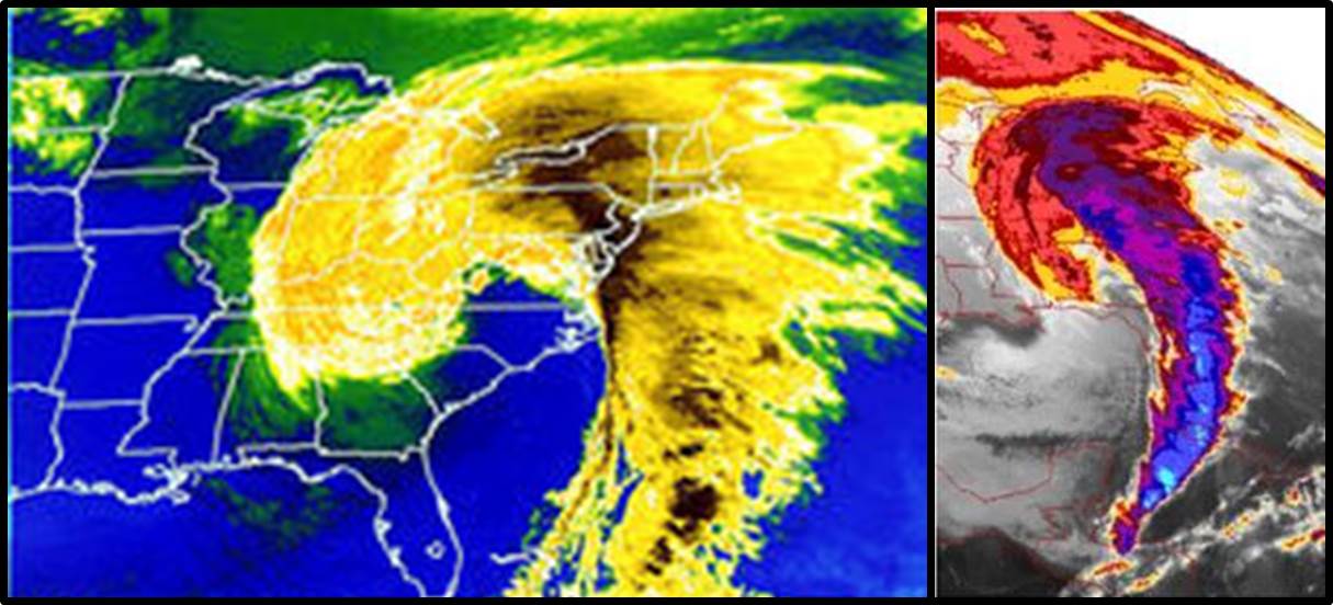
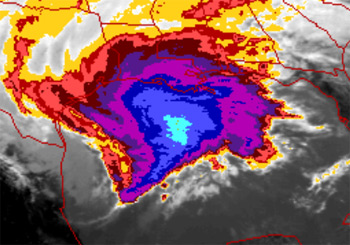
Here are some archived reanalysis charts of the overall upper air pattern that contributed to the development of the March 12-15, 1993 Superstorm. Satellite imagery of the system is also provided.
Upper Air
NCEP Reanalysis: 12Z March 12 | 00Z March 13 | 12Z March 13 | 00Z March 14 | 12Z March 14
500mb Charts: 12Z March 12 | 12Z March 13 | 12Z March 14
Surface Maps: 12Z March 12 | 12Z March 13 | 12Z March 14
Visible
March 12: 12Z | 15Z | 18Z | 21Z
March 13: 00Z | 03Z | 06Z | 09Z | 12Z | 15Z | 18Z | 21Z
March 14: 00Z
Infrared
March 12: 12Z | 15Z | 18Z | 21Z
March 13: 00Z | 03Z | 06Z | 09Z | 12Z | 15Z | 18Z | 21Z
March 14: 00Z
Water Vapor
March 12: 12Z | 15Z | 18Z | 21Z
March 13: 00Z | 03Z | 06Z | 09Z | 12Z | 15Z | 18Z | 21Z
March 14: 00Z
Click time to enlarge or move mouse over links to change images

As the low pressure system deepened and moved across the northern Gulf of America, snowfall began to accumulate across Mississippi. Amounts of 4 to 6 inches of snowfall were common across the state. The highest snowfall accumulation was 9.0 inches in Waynesboro, MS. Even along the coast where snow is a rarity, 1- to 2-inch snowfall amounts were common. Surface high pressure and a cold airmass moved in the wake of the system. Low temperatures fell into the teens between March 13-15 across the state.
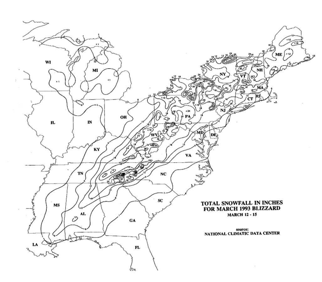
Here is a map of total snowfall across Mississippi and nationwide between March 12-15.

In the south, where public works facilities in most areas generally have no reason to be prepared for snow removal, the storm is remembered because it resulted in a complete shutdown of some regions for three days. Cities that usally receive little snowfall such as Chattanooga, Tennessee received anywhere from 2 to 4 feet of snow. This had caused some cities to adopt an emergency winter-weather plan for the future. Birmingham recorded a record low of 2°F during the storm. Syracuse, New York received 43 inches from the storm. New York reported a total of 12 inches. Two feet of snow fell in Hartford, Connecticut. The weight of the snow collapsed many factory roofs in the South. Snowdrifts on the windward side of buildings caused a few decks with substandard anchors to fall from homes. The heaviest snowfall was at Newfound Gap, where US Highway 441 crosses the Tennessee and North Carolina border, recorded five feet of snow and drifts up to 14 feet were observed at Mount Mitchell. There was wind gusts there as high as 110 mph according to NCDC. Power outages, on the average, lasted for one to two weeks all over the east. The blizzard from this storm system caused a total of $6.6 billion of damage. Nearly 60,000 lightning strikes were recorded as the storm swept over the country, for a total of seventy-two hours, and many may remember their local news organizations touting the term "thundersnow".
Thousands of people were isolated by record snowfalls, especially in the Georgia, North Carolina, and Virginia mountains. Over 200 hikers were rescued from the North Carolina and Tennessee mountains. Curfews were enforced in many counties and cities as 'states of emergency' were declared. The National Guard was deployed in many areas to protect lives and property. Generally, all interstate highways from Atlanta northward were closed.
On the winter aspect of this storm system areas as far south as central Alabama and Georgia received 4 to 6 inches of snow. Some areas received heavier amounts like 12 inches in Birmingham Alabama with some reports of 16 inches area the metro area. The Florida Panhandle had some 2 inch amounts, which was accompanied by hurricane force winds and record low barometric pressures.

|
|
||||||||||||||||||||||||||||||||||||||||||||
|
|
||||||||||||||||||||||||||||||||||||||||||||||||||||||||||||||||||||||||||||||||||||||||||||||||||||||||||||||||||||||||||||||||||||||||||||||||||||||||||||||||||||||||||||||||||||||||||||||||||||
References:
2. NWS Birmingham, AL: Remembering the "Blizzard of 1993"
3. NWS Wilmington, NC: Superstorm of 1993