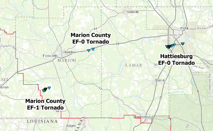
October 31, 2015 Pine Belt Tornadoes

Click on map above to see entire damage point notation and damage pictures at select points.
Marion County EF-1 Tornado
|
Event Summary
This brief tornado developed along Lowery Loop, crossing New Hope Road, and ending along Pounds Road. It caused damage to the roofs of several homes and destroyed several sheds. Numerous trees were snapped and uprooted.
|
Rating:
(Click for EF Scale) |
EF-1 |
| Estimated Maximum Wind: |
95 mph |
| Fatalities/Injuries: |
none |
| Damage Path Length: |
1.7 miles |
| Maximum Path Width: |
200 yards |
| Approximate Start Point/Time: |
3.5 SE Kokomo
3:27 pm
|
| Approximate End Point/Time: |
4.5 NW Sandy Hook
3:32 pm
|
|
Marion County EF-0 Tornado
|
Event Summary
This weak tornado touched down along Lampton Hill Top Road and moved east-northeast to Enon Road. A few trees were blown down and limbs snapped along a narrow path.
|
Rating:
(Click for EF Scale) |
EF-0 |
| Estimated Maximum Wind: |
75 mph |
| Fatalities/Injuries: |
none |
| Damage Path Length: |
1.0 miles |
| Maximum Path Width: |
50 yards |
| Approximate Start Point/Time: |
5.0 S Improve
3:46 pm
|
| Approximate End Point/Time: |
5.0 S Improve
3:47 pm
|
|
Hattiesburg EF-0 Tornado
|
Event Summary
This weak tornado touched down along Richburg Road just west of I-59. It tracked east northeast for 4.5 miles across a neighborhood and US Highway 11 before lifting at McCall Street and Barkley Road. The damage was mainly to trees where many of these had broken limbs with several even uprooted. Some homes had minor damage from downed trees or shingles torn off the roof.
|
Rating:
(Click for EF Scale) |
EF-0 |
| Estimated Maximum Wind: |
85 mph |
| Fatalities/Injuries: |
none |
| Damage Path Length: |
4.5 miles |
| Maximum Path Width: |
100 yards |
| Approximate Start Point/Time: |
4 SW Hattiesburg
4:24 pm
|
| Approximate End Point/Time: |
2 SE Hattiesburg
4:29 pm
|
|