December 20th-21st 2013 Severe Weather
Event Summary
A strong upper level system took shape over the southwestern United States and brought strong winds aloft over the region beginning December 20th. Moisture streamed into the the ArkLaMiss as increasing wind shear moved in advance of the upper level system and frontal system moving toward the region. As surface dewpoints climbed into the low to mid 60s on December 20th, the potential for strong to severe weather began to increase across the ArkLaMiss. One lone supercell storm developed over southwest Mississippi near Natchez and intensified as it moved into western to central Mississippi. Just enough wind shear and moisture was present far ahead of the main upper level feature to produce two tornadoes, one in Warren County and another in Hinds County. These tornadoes were very small, quick and brief. The damage was minor and no fatalities or injuries occurred.
As the upper level system ejected out through the Central Plains on December 21st, moisture increased into the mid to upper 60s in the southern half of the area while strong winds in the upper atmosphere increased across the ArkLaMiss Delta. The combination of factors increased the potential for severe weather and tornadoes across the region. A squall line began to take shape across western to central Louisiana early to mid Saturday afternoon. The squall line gradually moved to the east-northeast and some bowing structures and embedded supercells developed in the ArkLaMiss Delta. The supercells produced a tornado in the far northwestern portions of the ArkLaMiss Delta. The tornado began in Chicot County, southeast of Dermott, and tracked through Chicot and Desha counties, both in Arkansas, and dissipated in Bolivar County, northwest of Cleveland, in Mississippi. EF2 damage was found northwest of Cleveland, Mississippi in Bolivar County. Four 18-wheelers were overturned, causing two injuries, and many houses had minor to moderate damage. As the squall line progressed east through the night, multiple trees and powerlines were downed, causing damage as it moved across Mississippi. A 64-mph wind gust was recorded at the Cleveland Municipal Airport. The line of storms weakened later in the evening and finally moved mostly out of the region in the early morning hours of December 22nd.
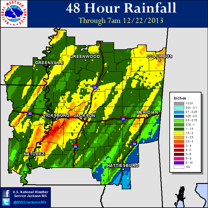
In addition to the damage from the line of storms, strong gradient winds ahead of the storms caused trees and powerlines to be downed in Adams, Clarke and Jones counties. Winds were measured between 45-50mph ahead of the line of the storms at the Greenville, Greenwood and Meridian airports. Rain fell during the afternoon to evening hours of the 21st, bringing widespread 1 to 3 inches to the ArkLaMiss. The heaviest rain fell along the Natchez Trace Parkway corridor in western Mississippi, where 3 to 4 inches was recorded.
Tornado Track Map
Click on map above to see entire event tracks and damage point notation. Individual track maps also available on individual tornado pages.
Survey Information - Click on the location in the table for additional maps and details
| Location | Start/ End Time |
Event Type | Fatalities/ Injuries |
Path Length | Path Width |
| Warren County 2 WNW Reganton |
12/20 4:41 pm - 4:42 pm |
EF-0 Tornado 70 mph |
none | 0.6 miles | 50 yards |
| Hinds County 2 S Newman |
12/20 4:56 pm - 4:57 pm |
EF-0 Tornado 65 mph |
none | 0.1 miles | 30 yards |
| Chicot/Desha/Bolivar counties 5 ESE Dermott, AR to 5 NNW Cleveland, MS |
12/21 4:51 pm - 5:28 pm |
EF-2 Tornado 115 mph |
Deaths: 0 Injuries: 2 |
41 miles | 1/4 mile |
Local Storm Reports
Click on the map below for additional details.
Rainfall Totals
Storm Total Rainfall

Mississippi Rainfall Totals
12/21 - 12/22