Event Summary
A vigorous, fast-moving early autumn storm system brought severe weather to portions of the ArkLaMiss region from the evening of Wednesday October 17th 2012 into the early morning hours of Thursday October 18th. The combination of intense wind shear, very strong forcing, along with adequate moisture and instability levels across the region resulted in severe storms developing ahead of and along a strong cold front as it raced east across the forecast area during the overnight hours. Numerous reports of wind damage from intense supercell and bowing-type thunderstorms were received as they produced strong straight line winds and tornadoes across the area from the Delta Region, southeast into Central Mississippi, and reaching into parts of East Central and Southeast Mississippi. There were sporadic reports of hail, but with such fierce wind shear over the region, straight line winds and tornadoes were the primary modes of severe weather during this event.
To put some historical perspective on this "rare" early Fall severe weather event, the EF-3 that occurred across Scott/Newton counties was only the 2nd F3 to occur in the month of October across MS in recorded history. The 3 strong tornadoes for this event is 2nd all time to the Oct 17, 1980 event where 7 tornadoes occurred (6) of which were strong (F2). Additionally, there were 11 total tornadoes during this event which ties Oct 13, 2001 for the most tornadoes during any October event.
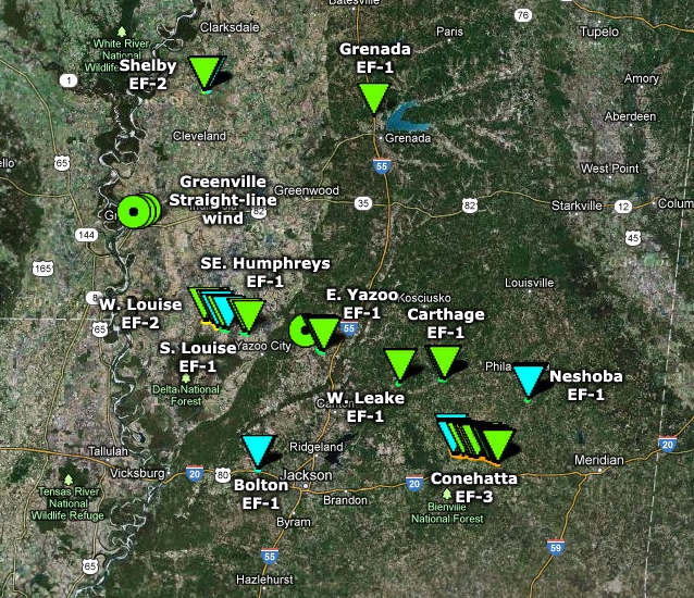
Tornado Track Map
The map below shows the locations of surveyed tornado tracks as determined by the National Weather Service Office in Jackson. The graphic is followed by a separate table detailing each surveyed tornado track. Maps for individual tornadoes can be found on those subsequent pages.

Survey Information - Click on the location in the table for additional details
| Location | Start/ End Time |
Event Type/ Max Winds |
Fatalities/ Injuries |
Path Length | Path Width |
| Bolivar County 3.5 NE Shelby to 4.75 NE Shelby |
Wed 10/17 9:07 pm - 9:09 pm |
EF-2 Tornado 115 mph |
none | 1 1/4 mile | 150 yards |
| Washington County 1.0 SW Greenville to 2.0 SE Greenville |
Wed 10/17 9:35 pm - 9:40 pm |
Straight-line wind 80-90 mph |
none | 4 miles | 1.5 miles |
| Grenada County 5.5 NNW Grenada to 5.5 N Grenada |
Wed 10/17 10:12 pm - 10:12 pm |
EF-1 Tornado 105 mph |
none | 1/2 mile | 75 yards |
| Sharkey and Humphreys counties 7 E Anguilla to 3 W Louise |
Wed 10/17 10:40 pm - 10:45 pm |
EF-2 Tornado 125 mph |
Deaths: 0 Injuries: 4 |
7 miles | 1/4 mile |
| Humphreys County 3 SW Louise to 2 S Louise |
Wed 10/17 10:46 pm - 10:49 pm |
EF-1 Tornado 110 mph |
none | 3 miles | 100 yards |
| Humphreys County 5 SE Louise to 7 NW Yazoo City |
Wed 10/17 10:56 pm - 10:59 pm |
EF-1 Tornado 90 mph |
none | 2 miles | 100 yards |
| Yazoo County 8 NE Benton to 7 W Pickens |
Wed 10/17 11:29 pm - 11:32 pm |
EF-1 Tornado 90 mph |
none | 2 miles | 250 yards |
| Leake County 10 W Carthage to 9.5 W Carthage |
Thu 10/18 12:11 am - 12:12 am |
EF-1 Tornado 95 mph |
none | 0.5 miles | 525 yards |
| Leake County 2 ENE Carthage to 2.5 E Carthage |
Thu 10/18 12:32 am - 12:34 am |
EF-1 Tornado 110 mph |
none | 1.3 miles | 150 yards |
| Scott and Newton counties 3 SE Harperville to 5 NE Lawrence |
Thu 10/18 12:46 am - 1:09 am |
EF-3 Tornado 140 mph |
Deaths: 0 Injuries: 1 |
16.25 miles | 1/2 mile |
| Hinds County 2 NE Bolton to 2.5 NE Bolton |
Thu 10/18 1:01 am - 1:03 am |
EF-1 Tornado 100 mph |
None | 0.52 miles | 50 yards |
| Neshoba County 2 WSW Bethsaida to 1 W Bethsaida |
Thu 10/18 1:12 am - 1:14 am |
EF-1 Tornado 100 mph |
None | 1 mile | 150 yards |
Local Storm Reports
Click on the map below for additional details.

National Storm Reports
Click on the map below for additional details.
Rainfall Totals
Storm-total twenty four hour rainfall amounts of 1 to 2 inches were common across the area. Isolated locations received over 3 inches. Two of the higher reported totals include 3.03 inches in Newton and 3.00 inches at the Turkey Creek Water Park near Decatur, both in Newton County. The map below shows where the highest rainfall accumulations occurred.