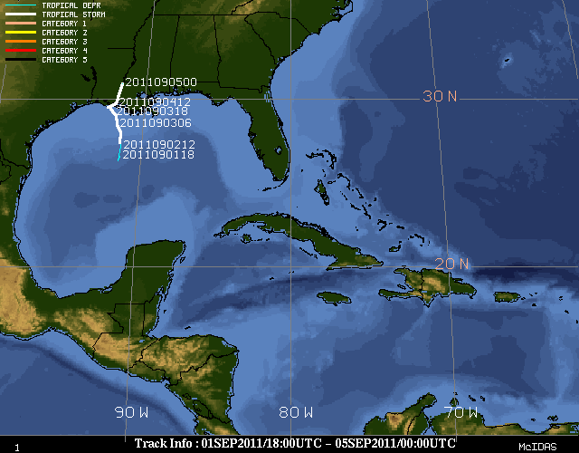
Track of Tropical Storm Lee

(Image courtesy of University Of Wisconsin - Madison Cooperative Institute for Meteorological Satellite Studies)
Event Summary
Tropical Depression 13 formed on the evening of September 1, 2011 about 225 miles southwest of the mouth of the Mississippi River with maximum sustained winds of 35 mph. This depression moved very slowly, around 2 mph, to the northwest in the northern portions of the Gulf of America. Through mid-day on the 2nd, TD 13 remained mostly stationary along the southeastern Louisiana coast, drenching Louisiana with several inches of rain. Around 1 pm on the 2nd, the depression was found to have strengthened by hurricane hunters and observations on oil rigs into the 12th named storm of 2011, becoming Tropical Storm Lee. Lee had moved little and was located 200 miles southeast of Cameron, LA, or 210 miles to the southwest of the mouth of the Mississippi River. Maximum sustained winds of 40 mph were found with the newly named tropical storm and a minimum central pressure of 1003 mb.
Lee continued to move very slowly on the 2nd and 3rd, while heavy rain and strong winds continued to lash southern Louisiana. By mid-day on the 3rd, Lee stalled south of the Louisiana coast with sustained winds around 60 mph. Lee continued to meander just along or south of the Louisiana coast through the remainder of the 3rd. During the early morning hours of the 4th, Tropical Storm Lee finally made landfall near Vermillion Bay, LA, with maximum sustained wind speeds of 45 mph. However, Lee was still moving very slowly to the north northeast, dumping large quantities of rain and spawning tornadoes across portions of southern Louisiana, southeastern Mississippi and other portions of the Gulf Coast.
As the center of Lee continued to trek northward, heavy rainbands spiraled across much of Central Mississippi to produce significant flooding issues. Rainfall amounts of 4 to 10 inches were common across the NWS Jackson County Warning Area, with a few locations reporting amounts around 10 to 13 inches. Significant flash flooding was reported in the Jackson metro area, along with locations in South Mississippi. Reports from emergency manager officials indicate that at least 50 homes, 60 apartment units and several other buildings were flooded by Monday morning. Numerous vehicles in the Jackson area were flooded, primarily in low-lying parking spots. Dozens of roads and bridges were washed out in Central Mississippi. U.S. Highway 80 and Interstate 20 east of Jackson were both closed due to high water. Locations in the Mississippi Delta, Northeast Louisiana and Southeast Arkansas saw the least amount of rainfall, with amounts generally ranging from half of an inch to 2 inches. Rivers responded to the large volume of rain, with many points on the Pearl River forecasted to go into minor to low-end moderate flooding. Other smaller creeks were also forecast to come close to flood stage.
In addition to the significant rainfall and flooding, tornadoes also occurred with Tropical Storm Lee. Four confirmed torndaoes occurred in the Jackson County Warning Area. As is the case with most tropical systems, these tornadoes were very brief and fairly weak. Much of the damage was EF-0 type damage, with mostly trees and limbs coming down. The strongest tornado was rated EF-1 near Collins, MS. Some structural damage occurred along with tree damage. This tornado tracked for 3 miles with maximum estimated winds at 90 mph.
Around 10pm on September 4th, Lee was weakened to a tropical depression with maximum sustained winds of 35 mph. However, these winds were occurring well to the south and southeast of the center over water. This weakened cyclone was located about 55 miles to the west southwest of McComb, MS. The remnants of Lee got caught up with an approaching cold front and moved off to the northeast, causing more rainfall for the Mid-Atlantic region that was doused by Hurricane Irene only a week prior.
Survey Information- Click on the location in the table for additional maps and details
| Location | Start/ End Time |
Event Type | Fatalities/ Injuries |
Path Length | Path Width |
| Lamar County 4 ESE Sumrall to 4 ESE Sumrall |
9/4 8:05 am- 8:05 am |
EF-0 Tornado 75 mph |
4/10 miles | 40 yards | |
| Forrest County 4 NW McLaurin to 4 NW McLaurin |
9/4 7:45 pm- 7:45 pm |
EF-0 Tornado 70 mph |
1/4 miles | 40 yards | |
| Covington County 6 S Collins to 4 SW Collins |
9/4 8:05 pm- 8:09 pm |
EF-1 Tornado 90 mph |
3 miles | 50 yards | |
| Smith County 3.8 SE Pineville to 3.2 SE Pineville |
9/4 10:45 pm- 10:46 pm |
EF-0 Tornado 70 mph |
6/10 miles | 50 yards |
Rainfall and Flooding
Due to the slow movement of Tropical Storm Lee, many locations in Central Mississippi and South Louisiana received significant rainfall. Amounts of 4 to 10 inches were widespread across much of the area south of a line from Winnsboro, LA to Columbus, MS. The heaviest concentration of rain fell in the southwest, around Natchez, as well as across locations east of Interstate 55. Significant flooding occurred as a result of the record amount of rain, as well as minor to moderate flooding along the Pearl River.
Rainfall totals, records and pictures
Local Storm Reports