Event Summary
A potent storm system brought an extended period of severe weather to the Arklamiss region beginning in the afternoon hours of Friday, April 23rd and lasting through the late evening hours of Saturday, April 24th. Scattered severe thunderstorms developed and moved across northeastern Louisiana and parts of Mississippi during the afternoon and evening hours. Several reports of large hail were received from across the area, including golf ball size hail in Sunflower County. In addition, some wind damage was reported over southern portions of Leflore County in association with a possible tornado.
Though the storms on Friday did not cause widespread damage, a much more dangerous situation unfolded across the region on Saturday. Initially, two separate clusters of strong to severe thunderstorms affected the area during the morning hours. One moved across southeastern Arkansas and northwestern Mississippi, dropping hail up to golf ball size. Another moved across south central and southeastern Mississippi, producing large hail and some wind damage. One of the storms over southern Mississippi produced a possible tornado as it moved from southern Simpson County across Smith County, northern Jasper County, and into the Meridian area in Lauderdale County. The same storm produced golf ball size hail across Smith County.
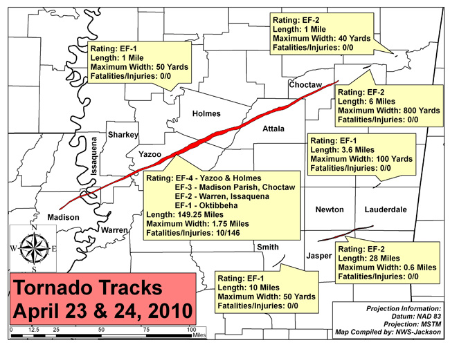
However, the most destructive storm of the day developed over northern Louisiana during the mid to late morning hours. The first report of damage was received shortly after 11am near the city of Tallulah. From that point, things only got worse as the supercell tracked from west to east across the entire state of Mississippi. Along the way, it produced significant damage in several locations including the Eagle Lake area of Warren County, Valley Park in Issaquena County, Satartia and Yazoo City in Yazoo County, Ebenezer and Durant in Holmes County, north of Kosciusko near Hesterville in Attala County, French Camp and Chester in Choctaw County, north of Starkville in Oktibbeha County, and east of West Point in Clay County. Multiple fatalities and injuries were reported in association with the storm, and several structures were damaged or destroyed.
Later in the evening hours, additional storms lingered over portions of east central Mississippi. Large hail was reported with some of these storms, including hail to the size of tennis balls in southern Lowndes County. One storm northwest of Meridian produced an apparent tornado along the Lauderdale-Kemper County line. Several trees were downed and some minor structural damage was reported in the area.

| Location | Start/ End Time |
EF Rating/ Max Wind Speed |
Fatalities/ Injuries |
Path Length | Path Width |
| Leflore County 2 NE Swiftown to 3 NE Swiftown |
Fri 4/23 3:48 pm - 3:49 pm |
EF-1 105 mph |
0 | 1 mi | 50 yds |
| Smith County 9 SW Hillsboro to 2 E Raleigh 31.952 N, 89.641 W to 32.032 N, 89.493 W |
Sat 4/24 8:40 am - 8:55 am |
EF-1 95 mph |
0 | 10 mi | 50 yds |
| Jasper/Newton/Lauderdale Co. 2 NE Montrose to 2 N Savoy 32.15 N, 89.206 W to 32.303 N, 88.763 W |
Sat 4/24 9:15 am - 9:52 am |
EF-2 125 mph |
0 | 28 mi | 0.6 mi |
| Madison Parish LA/Warren/ Issaquena/Sharkey/Yazoo/ Holmes/Attala/Choctaw/ Oktibbeha counties 5 W Tallulah to 5.5 N Sturgis 32.408 N, 91.283 W to 33.43 N, 89.054 W |
Sat 4/24 11:06 am - 1:52 pm |
EF-4 170 mph |
Dead: 10 Injured: dozens |
149.25 mi | 1.75 mi |
| Oktibbeha County 4 NW Starkville to 7 NNE Starkville 33.518 N, 88.857 W to 33.56 N, 88.77 W |
Sat 4/24 2:09 pm - 2:16 pm |
EF-2 115 mph |
0 | 6 mi | 800 yds |
| Clay County 5 ENE West Point to 6 ENE West Point |
Sat 4/24 2:28 pm - 2:29 pm |
EF-2 115 mph |
0 | 1 mi | 40 yds |
| Lauderdale/Kemper counties 3.5 WSW Prismatic to 2 NW Prismatic 32.574 N, 88.829 W to 32.604 N, 88.768 W |
Sat 4/24 7:24 pm - 7:39 pm |
EF-1 95 mph |
0 | 3.6 mi | 100 yds |
Storm Reports
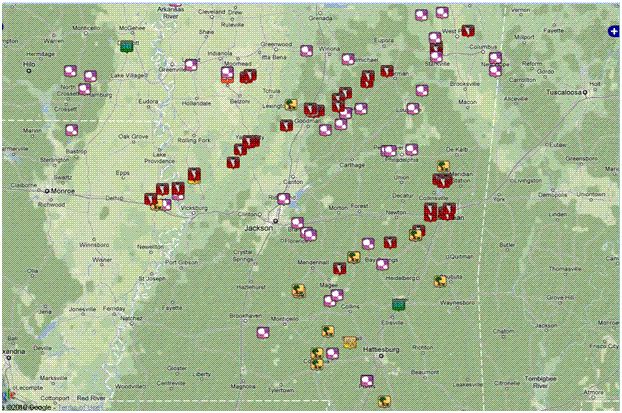
Below is a map of severe weather reports (including hail, damaging winds, tornadoes, and flash flooding) received by the National Weather Service in Jackson from this event.

The NWS would like to thank all of our partners in law enforcement and emergency management for their invaluable assistance in performing our damage surveys.