Jackson, Mississippi
Weather Forecast Office
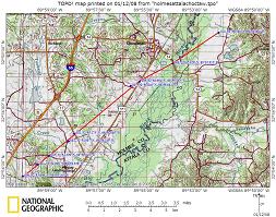
Beginning Point: 2 mi WNW of Pickens at 1151 AM CST
Ending Point: 2 mi ENE of Goodman at 1204 PM CST
Rating: EF-3 with maximum winds of 140 MPH
Path Length: 10 miles
Maximum Width: 0.75 mi
Casualties: 3 Injuries
Summary of Damage: The tornado started with a narrow path of scattered downed trees. The damage intensified as it approached Highway 17. Here tree damage became much more intense with hundreds of trees snapped and uprooted. One home had a portion of its roof ripped off. The tornado intensified and reached its maximum intensity and width between Highway 17 and U.S. Highway 51. Hundreds of trees were snapped and uprooted, some of them hardwoods that were snapped off except for a few large limbs and partially debarked. Several mobile homes were obliterated and two homes of wood frame and concrete block construction had nearly all of the outer walls collapsed along with total roof removal. Large missiles were generated, including a pickup truck that was thrown nearly 150 yards. On the east side of U.S. Highway 51, three high tension steel power poles were snapped off near the base. As the tornado continued east-northeast and moved into Attala County, the path narrowed and damage became limited to tree damage before dissipation just inside the Attala County line.
US Dept of Commerce
National Oceanic and Atmospheric Administration
National Weather Service
Jackson, Mississippi
234 Weather Service Dr.
Flowood, MS 39232
601-936-2189
Comments? Questions? Please Contact Us.


