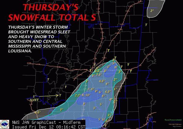
A rare early December heavy snow event unfolded across the south starting late on the 10th and really ramping up on the 11th. An upper level low deepened across the northern gulf and produced a swath of snow from southeast Texas, Louisiana, and into Mississippi. This was an unsual snow because temperatures ranged from 32 to 35 degrees where the snow fell. The upper low provided its own cold air and that was enough to allow rain to change to snow, especially where precipitation was heavy. Snowfall amounts ranged from 1 to 9 inches across our service area. The heaviest snow fell within an axis from McComb to Morton Mississippi. Areas that did receive more than 2 or 3 inches had trees and power lines down from the weight of the snow which resulted in many power outages. Roads were slick as well because of the fast accumulation and slushy conditions. Numerous accidents have occurred from the hazardous road conditions.
Click below to see precipitation totals across the area. These totals are the water equivalent of any precipitation that fell. The totals include rainfall, melted sleet, and melted snow.

Total Snow Accumulations |
||
| 3-4 E New Hebron | NW Jeff Davis County | 9 Inches |
| Bogue Chitto | Lincoln County | 8 Inches |
| New Hebron | Lawrence County | 8 Inches |
| Martinville | Simpson County | 7 Inches |
| Magee | Simpson County | 5 Inches |
| Hillsboro | Scott County | 5 Inches |
| Columbia | Marion County | 5 Inches |
| Kokomo | Marion County | 5 Inches |
| Jayess | Lawrence County | 5 Inches |
| Brookhaven | Lincoln County | 5 Inches |
| Roosevelt St Park | Scott County | 5 Inches |
| Florence | Rankin County | 5 Inches |
| D'Lo | Simpson County | 4.75 Inches |
| Collins | Covington County | 4.5 Inches |
| Braxton | Simpson County | 4 Inches |
| Topeka | Lawrence County | 4 Inches |
| Crystal Springs | Copiah County | 4 Inches |
| Mize | Smith County | 4 Inches |
| Taylorsville | Smith County | 4 Inches |
| West Hattiesburg | Lamar County | 4 Inches |
| Prentiss | Jeff Davis County | 4 Inches |
| Oma | Lawrence County | 4 Inches |
| Mt Olive | Covington County | 3.5 Inches |
| Johns | Rankin County | 3.5 Inches |
| 3S Madden | Leake County | 3 Inches |
| Puckett | Rankin County | 3 Inches |
| 2N White Oak | Smith County | 3 Inches |
| 5E McCall Creek | Lincoln County | 3 Inches |
| Hazlehurst | Copiah County | 3 Inches |
| Brandon | Rankin County | 2.5 Inches |
| Bay Springs | Jasper County | 2.5 Inches |
| McCall Creek | Franklin County | 2 Inches |
| Purvis | Lamar County | 2 Inches |
| Sebastapol | Scott County | 1 Inch |
| Rose Hill | Jasper County | 1 Inch |
| Ellisville | Jones County | 1 Inch |
| Roxie | Franklin County | 1 Inch |
| NWS Jackson | Rankin County | 0.9 Inches |
| Hattiesburg | Forrest County | 0.8 Inches |
These reports are based on reports from Emergency Management, Law Enforcement, Post Offices, NWS Employees, CoCoRaHs and Cooperative Observers, Broadcast Media, and the Public. |
||