Jackson, Mississippi
Weather Forecast Office
BEGINNING POINT: 4 W LAWRENCE 10:40 PM
ENDING POINT: 4 NW LAWRENCE
PATH LENGTH: 3.5 MILES
PATH WIDTH: 150 YARDS
PRELIMINARY FUJITA RATING: EF-1
CASUALTIES: NONE
SUMMARY OF DAMAGE: NUMEROUS HARDWOOD TREES UPROOTED ALONG WITH NUMEROUS LARGE PINES SNAPPED. THIS TORNADO TOUCHED DOWN ALONG PONDEROSA RD AND TRACKED NE...PARALLELING I-20...THEN CROSSING I-20 JUST TO THE W OF MILE MARKER 101. MANY LARGE PINE TREES WERE DOWN AT THIS LOCATION WITH SEVERAL TREES BLOCKING THE E BOUND LANES OF THE INTERSTATE.
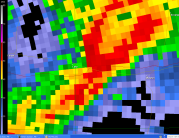
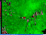
Below are some radar images.
 |
 |
US Dept of Commerce
National Oceanic and Atmospheric Administration
National Weather Service
Jackson, Mississippi
234 Weather Service Dr.
Flowood, MS 39232
601-936-2189
Comments? Questions? Please Contact Us.

