Jackson, Mississippi
Weather Forecast Office
BEGINNING POINT: JONESVILLE 7:13 PM
ENDING POINT: 3 WNW CLAYTON
PATH LENGTH: 16.5 MILES
PATH WIDTH: 500 YARDS
PRELIMINARY FUJITA RATING: EF-2
CASUALTIES: NONE
SUMMARY OF DAMAGE: THIS TORNADO TOUCHED DOWN IN JONESVILLE AND HEAVILY DAMAGED OR DESTROYED 6 MOBILE HOMES AND CAUSED MINOR DAMAGE TO 3 OTHER HOMES. NUMEROUS TREES WERE ALSO SNAPPED OR UPROOTED. THE DAMAGE IN JONESVILLE WAS NARROW...BETWEEN 75 AND 100 YDS WIDE...AND WAS IN THE EF-1 RANGE. THE TORNADO CROSSED THE TENSAS RIVER INTO CONCORDIA PARISH...THEN BACK INTO CATAHOULA PARISH BEFORE CROSSING THE RIVER A FINAL TIME INTO CONCORDIA PARISH AGAIN. THE TORNADO INTENSIFIED AND BECAME MUCH LARGER IN CONCORDIA PARISH. HERE THE PATH BECAME 500 YDS WIDE AND MANGLED...SNAPPED AND UPROOTED HUNDREDS OF TREES. NUMEROUS POWER LINES WERE ALSO TAKEN DOWN AND MANGLED ALONG THE PATH. NEAR DUNBARTON...2 MOBILE HOMES WERE DESTROYED AS THE TORNADO CONTINUED TOWARD CLAYTON. FOR THE MOST PART...THIS STRONG TORNADO REMAINED OVER RURAL AREA WITH MUCH OF THE PATH NOT ACCESSIBLE BY VEHICLE.
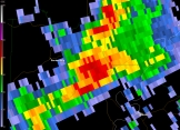
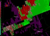
Below are some radar images.
Additional surveys will be conducted in the coming days and this page will be updated with more damage pictures, tornado track maps, and radar pictures as they become available.
US Dept of Commerce
National Oceanic and Atmospheric Administration
National Weather Service
Jackson, Mississippi
234 Weather Service Dr.
Flowood, MS 39232
601-936-2189
Comments? Questions? Please Contact Us.


