Call For Help: We continue to research the impacts of the March 3, 1966 tornado, and recently we have begun an effort to pinpoint more specific path information. Details about the path between the Cooper Road and Candlestick Park area in Jackson to the Flowood industrial area in western Rankin County are abundant. Information about the portion of the path in western Hinds County and areas from east of Flowood through Scott, Leake, and Neshoba counties is more spotty. If you or a relative have more information from any portion of the tornado path, especially these more rural areas, please send us an email at nws.jacksonms@noaa.gov.
On the afternoon of Thursday, March 3, 1966, one of the most devastating tornadoes in Mississippi history occurred. This tornado would come to be known as the “Candlestick Park” tornado, named after a shopping center in South Jackson which was destroyed by the tornado. Retrospectively rated an F5 tornado, the most violent category on the Fujita scale, this tornado carved a path of destruction across several counties in Central Mississippi. The worst damage occurred in parts of Hinds, Rankin, Scott, and Leake counties, where over 50 people were killed and over 500 were injured.
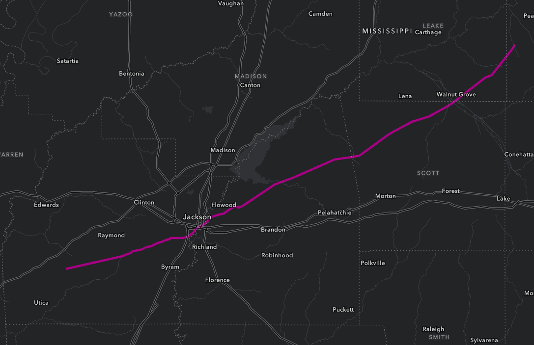
The tornado began around 4 PM near the Adams community between Raymond and Utica in southwestern Hinds County. It tracked east northeastward across largely rural areas of Hinds County, crossing Dry Grove Road before approaching the Midway Road area where the tornado claimed its first victims. Along Thigpen Road, the tornado demolished a homestead before toppling the recently constructed 1,600 foot WLBT broadcast tower just 50 feet above its base. As the tornado crossed Midway Road, it took the lives of three members of the Bowen family, including a couple and their grandson, when their home was hit. Just east of there, much of an AT&T long distance telephone relay tower was twisted off with only two sections at the base remaining. As a result, long distance telephone service in the Jackson area was lost for several hours in the immediate aftermath of the tornado until calls could be rerouted. The tornado then continued across Seven Springs Road, Springridge Road, Parks Road, and Siwell Road.

Along the north side of McClure Road, the tornado heavily damaged a large pecan orchard (now the Pecan Acres subdivision, where many of the surviving pecan trees still stand to this day) before reaching the intersection of Forest Hill Road and Cooper Road. Here, several homes were damaged or destroyed and most of the trees in a pine grove were snapped. A man who was driving near this intersection lost his life when he was thrown into a ditch by the tornado. Another man died when his home was destroyed. His wife was also injured. Next, the brick Woodville Heights Baptist Church and its neighboring parsonage at the intersection of Cooper and Fleetwood Drive were completely destroyed. The pastor's wife and son who were in the parsonage at the time were injured. At the intersection of Cooper and Ridgeland Drive, a building adjacent to Carter's Nursing Home was turned on its side. At this point, the tornado path took a clear turn from north of east to due east, virtually paralleling Cooper Road. Additional homes were damaged or destroyed as it crossed Rainey Road with another fatality occurring before the tornado took aim on Candlestick Park.
The tornado earned its name at the Candlestick Park Shopping Center. Opened in 1963, the center was home to Liberty Super Market, Southwest Drugs, the Family Five and Dime which hosted popular slot tracks, the Highlander Center laundromat, the Beauty Circle beauty salon, Neal's barber shop, and a doctors office. Across the parking lot from the shopping center was a small hamburger and hot dog restaurant called Fred's Dog 'n Suds, and closer to the roadway was the K and C Electric building. At 4:33 PM, within just a matter of seconds, most of the shopping center was flattened, with the exception of the Liberty Market, which was heavily damaged. The small restaurant was also destroyed with cars piled in the area where it once stood. The victims included a pharmacist, an employee at the laundromat, a cook at the restaurant, and a young employee of the market who was visiting the restaurant. A mother and her son who were in a vehicle and had pulled off the road at the shopping center perished, and two other sons in the car were injured. Scores of people were injured, some severely, and many of the survivors sustained permanently life-altering injuries. Several of the cars in the parking lot were lofted and tossed. Notoriously, a Volkswagon driven by Donna Durr who was accompanied by her young son was lofted into the air and landed on top of the wreckage of the K and C building, both of them escaping unharmed. Just east of Candlestick Park, the Mississippi Power & Light (now Entergy) Southwest Jackson Substation was heavily damaged, with six major transmission lines severed. Immediately east of the entrance road to the substation, the bridge deck of Cooper Road over Cany Creek was destroyed. Continuing a path paralleling Cooper Road, buildings at the Cooper Road Christian Church near the Rosemary Avenue intersection were heavily damaged, and a house at the corner of Cooper and Wheatley Street was overturned, landing upside down on its foundation. Additionally, a strip mall along Cooper between Beatrice Drive and Rickay Drive was damaged.

According to newspaper accounts, a helicopter overflight of the damage path revealed the tornado made a more northward turn as it approached the Pearl River and Rankin County. It would have crossed I-20 just west of the Pearl River, but that portion of the interstate was still being built at the time, sparing what would have been increasing rush hour traffic shortly after 4:30 PM.

The tornado crossed the Pearl River into Rankin County just south of the US Highway 80 bridge, tearing down utility poles and Mississippi Power & Light transmission lines and leaving wires tangled in the river. As the tornado crossed Highway 80, it hit the Billups service station and cafe. At the time, Highway 80 was the primary eastward route out of Jackson. The portion of I-55 just north of I-20 and the interchange now known as The Stack had not yet been built. The tornado would have passed just north of The Stack during a time of day characterized by heavy traffic. Continuing northeast, the tornado derailed at least six rail cars on the Illinois Central Railroad line just south of Old Brandon Road. Additional buildings were damaged as it crossed Old Brandon Road. Plate glass windows were blown out of Star Super Market #10 on the north side of the road, and a couple of homes were lifted off the foundation and set back down intact. Around this time, as part of major flood mitigation efforts, the Pearl River was being rerouted to its current channel. The tornado path continued along the old river channel, which is now known as Crystal Lake, covering some of the basins in debris.
Next, the tornado took aim on the town of Flowood. In 1966, the population of Flowood was focused in the area from north of Highway 80 to the industrial area along what is now MS Highway 468/Flowood Drive. At that time, this thoroughfare was called Fannin Road. The tornado tracked directly through the heart of the Flowood industrial area. First hit was Jackson Tile Manufacturing Company, where buildings were heavily damaged and a water tower was collapsed. Just north of Jackson Tile, Continental Can Company was heavily damaged. On the east side of the road, warehouse and manufacturing buildings were damaged at Knox Glass Bottle Company. East of Knox Glass, multiple buildings were smashed at Cataphote Corporation, a manufacturer of glass beads for signs. Five fatalities occurred in vehicles as the tornado crossed Fannin Road, including employees from Continental Can and Cataphote, a 10 year old whose father and brother were also seriously injured, and two men who were driving home from work when encountering the tornado. In the case of at least two of the vehicles, they were tossed at least 100 yards from the road. One Cataphote employee died and several others were injured while seeking refuge in a ditch.

Continuing northeastward, at around 4:45 PM the tornado impacted the Mississippi Air National Guard base on the northern end of the newly opened Jackson Municipal Airport, tearing bricks from the walls of one building. A two-seat Aeronca aircraft that was tied down in front of the Air National Guard hangar was lofted in one direction then tossed in another direction out of the tornado's path, destroying the plane. A 60 mph wind gust was measured at the Jackson Weather Bureau Office in the airport terminal building just over a mile south of the Air National Guard buildings. Based on times observed by witnesses at Candlestick Park and meteorologists at the Jackson Weather Bureau Office, the tornado was moving around 60 MPH, at least in the distance from Candlestick Park to the airport. From here, the tornado traveled through what was at the time a very rural area covered with farms and dotted by sporadic houses. Lakeland Drive had not yet been extended into Rankin County, and MS Highway 25 had not yet been built between Jackson and Carthage, thus the many businesses and neighborhoods that have since sprung up along that corridor did not yet exist. Near Brandon-Luckney Road (now just Luckney Road), a home was damaged and Mississippi Power & Light transmission lines were severed. The next road crossing was the Brandon Fannin Highway (now MS Highway 471). At its intersection with the new road leading to the Ross Barnett Reservoir(now Spillway Road), two house trailers were destroyed, and the roof structure and north wall was removed from a home that faced the highway. Another house trailer was stripped off the floor structure and scattered for several acres. The tornado crossed Pelahatchie Creek, and at least two more homes were destroyed along Holly Bush Road.
One of the areas of most intense damage along the tornado path was the Leesburg area in northeastern Rankin County. In the vicinity of MS Highway 43, both a frame house and a tenant house on the same property were destroyed. Three people died in the tenant house, including a woman and her child. The next property, further east along Highway 43 had a home lifted off its foundation. One man sustained severe injuries after being thrown around 200 yards, and several cattle perished. Next impacted was the area around the intersection of MS Highway 43 and MS Highway 481, where the Bilbro store was damaged, the Rankin County Health Department branch office was swept off its foundation and destroyed, a home and barn were destroyed, and two chicken houses were destroyed. The path of destruction continued east northeastward, roughly paralleling MS Highway 481. Several other homes and barns were destroyed, with many of the homes removed from the foundation. Several people occupying these structures sustained serious injuries. According to multiple reports after the tornado, around a quarter mile of pavement was removed from the roadbed and deposited into the neighboring fields with additional shorter segments of roadway destroyed. Some large trees were fully removed from the soil and tossed. The tornado dealt one more tragic blow as it exited the Leesburg area. On the east side of the road that follows the Rankin/Scott County line, just inside of Scott County, a home occupied by Rev. Marvin Pruitt, his wife, their three children, and his mother in law was destroyed, and all six family members died in the storm. For many years, a memorial stood at the site where the home once stood.

Northwestern and northern Scott County was heavily impacted by this tornado, and suffered the greatest human toll per mile of any portion of the tornado path. Though the tornado remained in mainly rural areas of the county including vast expanses of the Bienville National Forest, it still impacted numerous homesteads and several travelers on local highways. Following the deadly impact to the Pruitt home as the tornado entered the county, the Branch community was hard hit, with seven deaths reported. One teenage girl was thrown into a pond where she drowned. A couple and their infant son died. A salesman from the Russell area of Lauderdale County died when his car was swept off a road. From Branch, the tornado continued across the area north of Forkville. As it crossed MS Highway 13, two cars were tossed from the highway. A highway patrolman witnessed one of the cars, a station wagon, being lofted into the air and landing 200 yards away. The occupant Joe Bullock, an aspiring Congressional candidate, was returning home to Brandon from campaigning that day and sadly lost his life. The other vehicle which was tossed into a ditch was carrying three men who were traveling home to Good Hope from their workplace near Morton. Two of them died, with one tossed out of the vehicle into a yard on the opposite side of the highway. The third man sustained critical injuries but ultimately survived. Also along Highway 13, a recently constructed brick home was almost completely destroyed with only one wall left partially standing, two tenant houses were destroyed, and multiple chicken houses were destroyed. At the Balucta community along Hillsboro Ludlow Road, at least eight homes were destroyed, and eight people died, including multiple members of the Lyles, Armon, and Chambers families. The tornado then crossed through the Midway community, destroying the Lillian Missionary Baptist Church and Free Will Baptist Church and causing minor damage to the North Scott School. Additional homes were destroyed, and two more lives were lost. Finally, in the Pea Ridge community just south of Walnut Grove, a woman died after her home was hit by the tornado. Her husband was seriously injured when the truck he was driving was tossed around 100 yards into a nearby pasture. Additional homes, vehicles, barns, and chicken houses were destroyed in this area.

The tornado entered Leake County just southeast of Walnut Grove and tracked northeastward, impacting the Rosebud and Madden communities. It continued to damage and destroy several homes and farm buildings through this area. Minor damage occurred at both the Zion Baptist and Zion Methodist churches near Rosebud. Four people died across southeastern Leake County, all occupants of homes that were destroyed. The tornado entered Neshoba County near the Dowdville community, where more than 10 more houses were damaged or destroyed and two barns were destroyed. The old Carolina Church, built in 1841, was destroyed, while the new church sustained roof damage. At the Carolina cemetery, tombstones were reported pulled from the ground. The final victim of the tornado was Ocie Huddleston, whose home near the Leake/Neshoba County line was destroyed. According to local accounts, the tornado path ended somewhere over western Neshoba County around 6 PM, with no damage reported as the storm moved through the Philadelphia area. One or more additional brief tornadoes may have occurred in Mississippi beyond this area, including in the Preston area of Kemper County where trees were downed. Additional substantial tornado damage occurred in West Alabama.

In the era in which this tornado occurred, the Weather Bureau reported hazardous weather events in the Storm Data publication. Damage assessments often did occur for tornadoes, but they were generally far less thorough than the surveys conducted in the modern era. After this tornado, the US Weather Bureau did send a special team of meteorologists from the district office in Fort Worth, TX to inspect the local office, survey damage, and collect information about the receipt of warnings. However, the Storm Data entry for this tornado was brief and general. It listed the path as 200 miles long, while also clearly indicating there were very large gaps in this path, skipping "with brief touch downs in Neshoba and Kemper" counties. Based on modern practices, the path length of this tornado was likely closer to 84 miles, which would no longer rank as the longest tornado path in Mississippi history. It is possible, given the void in information from more rural areas, there were also some breaks within this 84 mile path; however, there are no confirmed breaks in this path.
In 1966, the primitive radar equipment in use at Hawkins Field in Jackson was only able to detect reflectivity, showing the intensity of rain and little more. For tornadoes, meteorologists had to rely far more on reports from spotters. On the day of the Candlestick Park tornado, a tornado watch was issued around two hours before the tornado occurred. Around 4:20 PM, a severe thunderstorm warning was issued for high winds and hail with the storm. The Weather Bureau Office was unaware of the tornado until contacted by a local TV station. By that time, electricity and communications had been knocked out, making it difficult to relay additional warnings. There are several accounts of individuals taking precautions and workers being sent home early as a result of the tornado watch and severe thunderstorm warning and based on news reports from local TV and radio stations.
The 250mb level showed a large and anomalous upper trough just east of the Rockies. Heights were some 3-4 standard deviations below normal values for early March. As for the winds, a strong jet stream was curving out of Mexico. The flow was strongly diffluent as the core of the jet lifted northeast while the rest of the flow turned more toward the east around the upper ridge. The jet stream, shown in m/s, was about 120-130 knots.


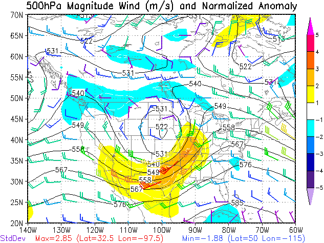
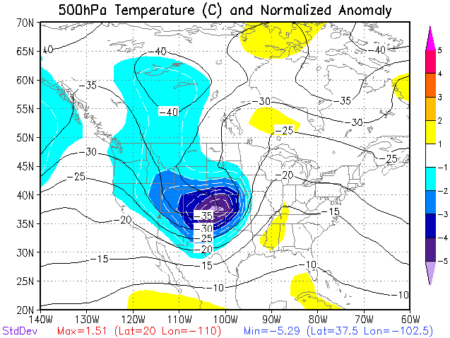
The 500 mb pattern was similar, showing a large mid-level closed low with a trough extending into Mexico. The heights were relatively low with this large system which is indicated by the area of 4 standard deviations. The mid-level flow was characterized by a strong mid-level jet extending from Texas to Missouri with a core of about 90 knots. Such a potent mid-level jet is somewhat rare, standard deviations are roughly 3. Across the region of interest, the mid-level temperatures were only slightly above what we typically see for early March. However, the core of the system had extremely cold air associated with it. Temperatures in the "cold core" were about -35 C which was greater than 5 standard deviations below normal. This provides an indication of the strong forcing associated with this large system.

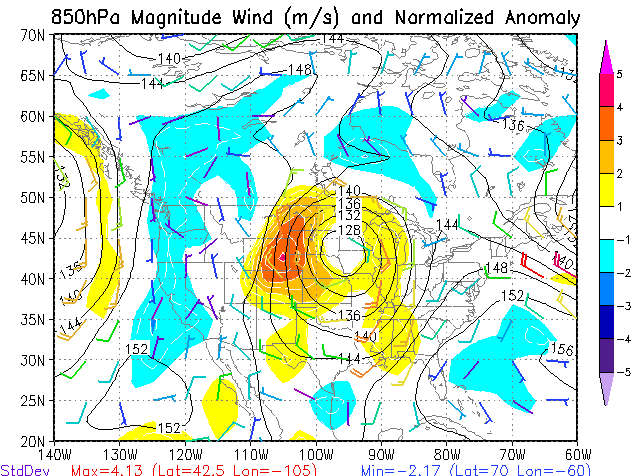
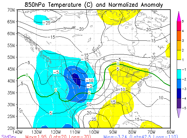
Down in the lower levels, the 850 mb closed low was centered over Sioux Falls, SD. This is somewhat far to the north for a low center during severe weather in our area. However, history has shown that some of the strongest and most devastating tornadoes across Mississippi have had the 850 mb and surface low across Kansas and Nebraska. Similar to the mid and upper levels, this low was large and quite strong and displayed deviations in the 2-3 range. The 850 mb winds were not overly strong and ranged about 40-45 knots. The interesting feature to note is the subtle wind shift associated with the "kink" in the height field. While this feature appears subtle, this was likely the feature that was the driving force in this severe weather event.

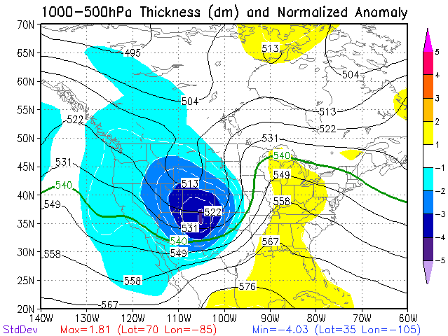
1000-500 mb thickness is a measure of the distance between the 1000 mb and 500 mb levels and is expressed in dm. Climatologically, a 1000-500 mb thickness between 561 and 567 dm is favorable for tornadoes. This tornado occurred very near the 566 and 567 dm contour.
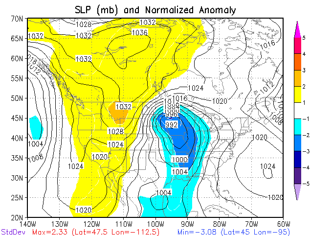
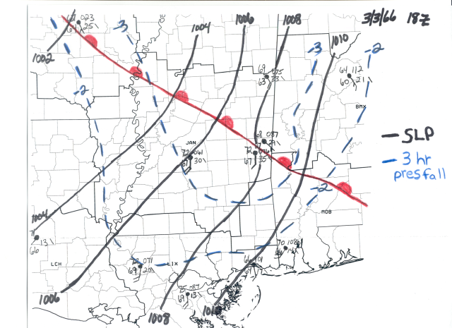
The surface low was rather deep with a front extending south. The deep low and trough are highlighted by the 2-3 standard deviation area. The 18z (noon) March 3rd surface map shows a warm front moved northward into Central Mississippi. This warm front separated the upper 60s dewpoints to the south from lower 60s dewpoints to the north. In the wake of the warm front were stout southerly winds ranging from 10-20 mph. There were also substantial 3 hour pressure falls area across Central and Northern Mississippi. By 21Z, roughly 1 to 1 1/2 hours before the tornado, the warm front pushed further to the northeast. Warm moist air remained south of the front with strong southerly winds. Significant 3 hour pressure falls continued across the region. In fact, there were even more pronounced pressure falls of nearly 4 mb to 5 mb in 3 hours from Jackson to Columbus. These large pressure fall regions were key in promoting surface moisture convergence and allowing the low-level winds to remain slightly backed. The final feature of note is the subtle wind shift and pressure trough located along the Mississippi River. This feature was likely the key to where thunderstorms developed. This feature was also reflected in the 850mb map.

This form shows the surface weather observations collected at the Weather Bureau Office at the new Jackson Municipal Airport. Observers first noted the tornado at 4:35 PM, then documented it reaching two miles northwest of the airport at 4:40 PM, and finally, observed it northeast of the airport moving away at 4:45 PM. The remarks for the next hourly observation at 4:58 PM noted the tornado had passed 1 1/8 mile north of the terminal, resulting in a peak wind gust of 60 mph and a minimum pressure reading of 963 mb.

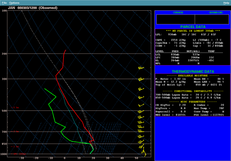
The 12Z (6 AM) sounding from Jackson shows that the warm front was still located south of Jackson given the cool inverted temperature profile in the lowest few thousand feet. There was abundant moisture below 850mb with a large amount of dry air above that. This dry layer provided steep lapse rates over the region with a cap in place. These steep lapse rates, combined with the high low-level moisture, provided substantial instability (~1554 J/kg of MUCAPE) above the frontal boundary. As the warm front lifted north, the warm surface temperatures would result in this instability becoming rooted at the surface and set the stage for an active day. The 00z (6pm) sounding was slightly modified to represent the surface conditions just before the tornado occurred. By this time, moisture increased and deepened in the low-levels. The cap was still present, but weaker, and was likely contributing to the limited amount of storms with more focused explosive development. The lapse rates remained steep and continued to support high levels of instability (~1538 j/kg of MLCAPE or ~2300 j/kg of SBCAPE). The wind fields were strong, resulting is high levels of shear. This 00z depiction of the winds was obtained after the storm passed, and therefore is unrepresentative of conditions when the tornado occurred. These winds are unidirectional (from the same direction) which confirms a wind shift or trough passage had occurred. Just ahead of the storm, winds were likely more from the south in the first 1-2 thousand feet and then more southwest, similar to what is shown on the sounding.

Central Mississippi was a very different place in 1966. Between the 1960 Census and the 2020 Census, population of the Jackson metropolitan area has grown by over 65 percent. Areas that were once rural and desolate are now filled with homes and businesses. Many new highways have been built, carrying many more cars.
In 1966, the Cooper Road area of Jackson was more of a border area between the city of Jackson and rural Hinds County. Today, this area is much more urbanized, with extensive housing development. Even areas west of Candlestick Park have become more developed with neighborhoods like Pecan Acres and Windsor Forest in the tornado's historical path. In 1966, I-20 and the portion of I-55 north of McDowell Road in Jackson had not yet been completed or opened to traffic. The tornado passed just north of the area now known as the Stack, a highly trafficked area especially during rush hour periods.
In Rankin County, much of MS Highway 468 had not yet been built, and there was no four lane road between Pearl and Flowood. Instead, the more rural Fannin Road carried traffic through the Flowood industrial area. Flowood as most people know it today did not yet exist. It was a small flood prone town anchored by a growing industrial area. Lakeland Drive did not yet extend into Rankin County, and Highway 25 did not yet exist between Jackson and Carthage. The 1966 tornado would have impacted a busier MS Highway 468, The Refuge golf course, the north side of the Jackson-Medgar Wiley Evers International Airport, portions of neighborhoods like Dogwood Place, Lineage, Castlewoods, Mill Creek, and the neighborhoods along Holly Bush Road.
The tornado moved through the Jackson metropolitan area between 430 PM and 5 PM, during the afternoon rush hour time period. This would have created very dangerous conditions for travelers along major highways like I-55, I-20, US Highway 80, Flowood Drive, West Rankin Parkway, Airport Road, East Metro Parkway, Lakeland Drive, and MS Highway 471, several of which did not exist in 1966.
Clearly, a violent tornado moving along this same path would be even more catastrophic from a damage perspective today than it was in 1966. While advanced meteorological technology and science along with improved communications would almost certainly yield more precise warning information to the public in the modern era, the increase in population and infrastructure along the path might still result in as many, or even more, casualties in the present day.
These facts remind us of the danger posed by these strongest of storms, violent (EF4-EF5) tornadoes. While they are rare - less than 3 percent of all tornadoes - they can result in tremendous damage and casualties. Residents should prepare in advance for tornado activity by having safety plans, having multiple ways to receive warning information, and keeping informed of the latest weather conditions, especially when conditions are favorable for tornadoes.
The science and technology of meteorology has changed dramatically since the Candlestick Park tornado. The tornado occurred at a time when research on severe thunderstorms and tornadoes was only beginning to accelerate. Just two years before, in 1964, the National Severe Storms Laboratory opened in Norman, OK. In the years following, NSSL was responsible for dramatic progress in the understanding of the development of severe thunderstorms and tornadoes. Unfortunately, in 1966 many of these discoveries were still in the future.
The process of issuing tornado watches and warnings to the public was still at a developing state in 1966. The National Weather Service was called the U.S. Weather Bureau and was structured to have a greater number of small offices in communities nationwide. Today, the National Weather Service has larger warning and forecast offices in most major cities. In 1966, the Weather Bureau office in Jackson was located in the terminal of the recently opened Jackson Municipal Airport. A World War II era weather radar which was incredibly primitive in comparison to the WSR-88D Doppler radar used by the NWS today was located at Hawkins Field.
To attempt to detect tornadoes with radar in 1966, weather radar operators would look into a viewing tube, like those used on military aircraft radar during war, and attempt to discern hook echoes as indicators of possible tornadoes. It had been understood since the 1950s that hook echoes were often correlated with the occurrence of tornadoes, but the reason why was not well understood. Just before the Candlestick Park tornado, in 1965, renowned research meteorologist Theodore Fujita, later the inventor of the Fujita tornado damage scale, published a paper theorizing the existence of the supercell thunderstorm. It was later shown definitively that the supercell was a special type of rotating thunderstorm, associated with the hook shaped echo on radar, which produced the overwhelming majority of tornadoes. This discovery paved the way for the development of Doppler radar, which detects the movement of air and the rotation within thunderstorms, enabling the advanced warning system of today.
In the 2010s, the upgrade of the WSR-88D systems to include dual polarization capabilities made it possible to confirm tornadoes with the detection of lofted debris, even in remote areas or at night when spotters might not be able to visually confirm a tornado. In the modern age, we would have almost certainly been aware of the tornado well before it reached Candlestick Park, with or without spotter reports.
Communications have also advanced tremendously over the last four decades. In 1966, the Weather Bureau relied on teletype and telephone to get warnings and statements out to the public. The teletype circuits utilized at that time operated at only about 75 words per minute, and it would often take several minutes for a warning to actually be prepared and transmitted on the teletype. There was no NOAA Weather Radio in Jackson in 1966. A Severe Thunderstorm Warning was issued in advance of the Candlestick Park tornado, but there was no Tornado Warning. By the time the Weather Bureau Office was aware of the tornado, communications had already been cut off. This is in stark comparison to the rapid communication of today, in which a warning message can be prepared by an NWS meteorologist in a matter of seconds, and once issued, be disseminated automatically and almost instantaneously via Wireless Emergency Alerts (WEA), NOAA All-hazards Weather Radio, media outlets, the Internet, and social media.
Advances in science and technology have enabled us to have a society that is much better prepared to survive the devastation of tornadoes. We at the National Weather Service, with our partners in emergency management and media, continue to strive to help people be prepared for severe weather. However, are also aware of the sobering reality that violent tornadoes like the one on March 3, 1966 will still produce tremendous damage and casualties, no matter how well we prepare and how much warning is provided.
Remembering the victims of the April 3, 1966 tornado. This listing is primarily based on news accounts shortly after the tornado and may be incomplete. If you are aware of any names or information we are missing, please reach out to us at nws.jacksonms@noaa.gov.
Many of the details of the tornado's impacts are based on accounts from the following individuals, publications and websites.

