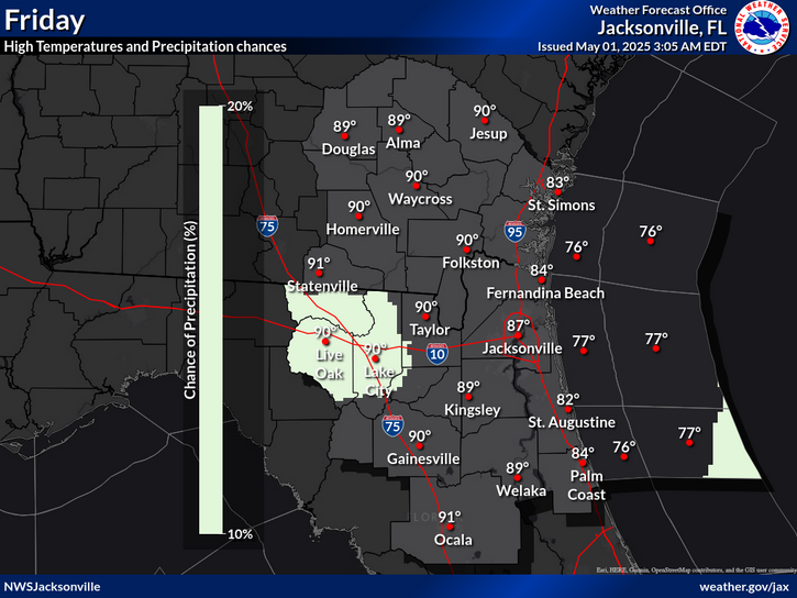
National Weather Service United States Department of Commerce
Click a location below for detailed forecast.

Last Map Update: Thu, Jul 3, 2025 at 8:02:13 pm EDT

The National Hurricane Center has increased 📈 the chances – Now at 50% – of a weak tropical disturbance organizing along an old stalled front over the local coastal Atlantic waters this weekend. Regardless of tropical cyclone development, flooding rainfall risk continues through Saturday, especially for north-central FL. Please continue to monitor the NHC information over the next couple of days.
⛈️Daily rounds of thunderstorms are expected through the weekend, with total rainfall up to 4 inches. This will elevate the flood risk for NE FL, especially across north-central FL where amounts will be the greatest. Travel hazards include slick roads and blinding downpours. Flooding of urban, low-lying and poor drainage areas are possible especially in Marion, Putnam and Flagler counties.
Climate statistics.

Text Product Selector (Selected product opens in a new window) 
 
Briefing Info
Decision Support
Radar
Fire Weather
Aviation
Rivers-Flooding
Briefing Info
Decision Support
Radar
Fire Weather
Aviation
Rivers-Flooding
Marine
Beach
Satellite
Hourly Forecasts
Climate
Social Media
Marine
Beach
Satellite
Hourly Forecasts
Climate
Social Media
Tropical
Observations
NOAA Weather Radio
Report Weather
Storm Spotters
Air Quality
Tropical
Observations
Weather Radio
Report Weather
Storm Spotters
Air Quality