Honolulu, HI
Weather Forecast Office
Wind speed. A combination of long/short barbs and pennants indicate the speed of the wind in station weather plots rounded to the nearest 5 knots. Calm wind is indicated by a large circle drawn around the skycover symbol.
One long barb is used to indicate each 10 knots with the short barb representing 5 knots. At 50 knots, the barbs changes to a pennant. For wind speeds higher than 50 knots, long and short barbs are used again in combination with the pennant(s). (See examples below.)
| Observed wind speed |
0-2 kts (0-2 mph) |
3-7 kts (3-8 mph) |
8-12 kts (9-14 mph) |
13-17 kts (15-20 mph) |
18-22 kts (21-25 mph) |
23-27 kts (26-31 mph) |
28-32 kts (32-37 mph) |
33-37 kts (38-43 mph) |
48-52 kts (55-60 mph) |
53-57 kts (61-66 mph) |
58-62 kts (67-71 mph) |
63-67 kts (73-77 mph) |
98-102 kts (113-117 mph) |
102-107 kts (119-123 mph) |
|---|---|---|---|---|---|---|---|---|---|---|---|---|---|---|
| Rounded to the nearest 5 |
0 kts | 5 kts | 10 kts | 15 kts | 20 kts | 25 kts | 30 kts | 35 kts | 50 kts | 55 kts | 60 kts | 65 kts | 100 kts | 105 kts |
| Plotted as |  |
 |
 |
 |
 |
 |
 |
 |
 |
 |
 |
 |
 |
 |
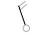
| Wind FROM 340° (NNW) |
Wind FROM 040° (NE) |
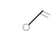
Wind FROM 190° (S) |
|---|---|---|
 |
 |
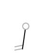 |
The wind direction is indicated by the long shaft. The shaft will point to the direction FROM which the wind is blowing. The direction is based upon a 36-point compass.
US Dept of Commerce
National Oceanic and Atmospheric Administration
National Weather Service
Honolulu, HI
2525 Correa Rd Suite 250
Honolulu, HI 96822
(808) 973-5286
Comments? Questions? Please Contact Us.

