Scattered severe thunderstorms capable of damaging wind gusts and some hail are expected this afternoon and evening from the Upper Ohio River Valley into the Northeast, and from the Appalachians into the Mid-Atlantic States. Excessive rainfall from heavy thunderstorms may produce areas of flash flooding from southern New Mexico into the western and northern Gulf Coast into Wednesday. Read More >
Overview
|
|
||||
|
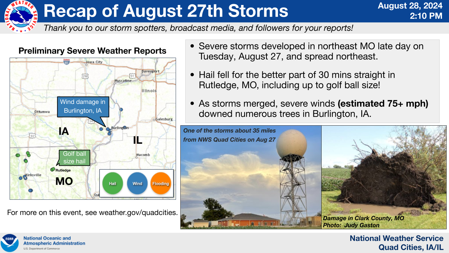
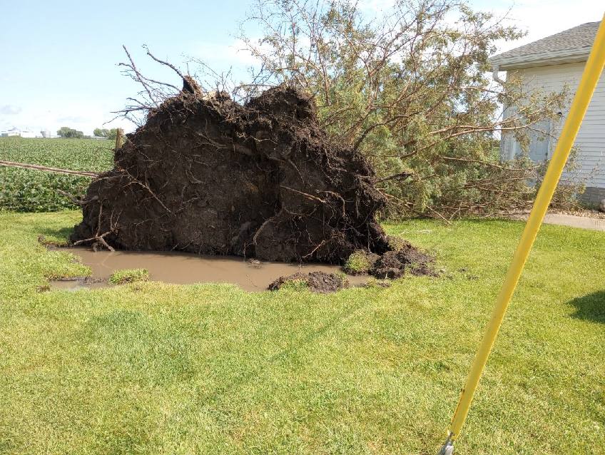
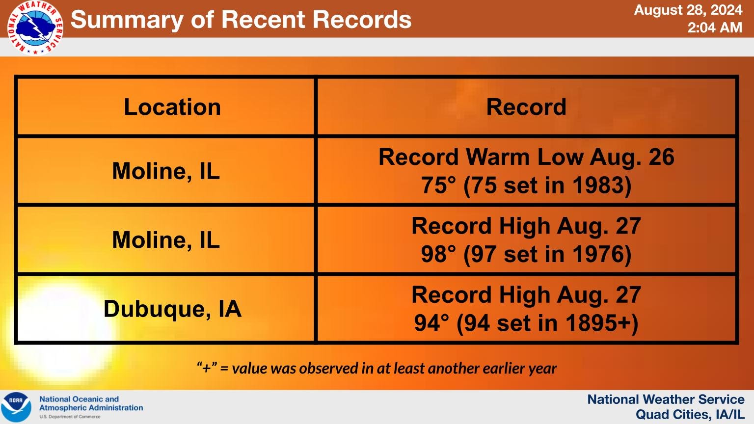
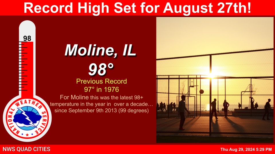
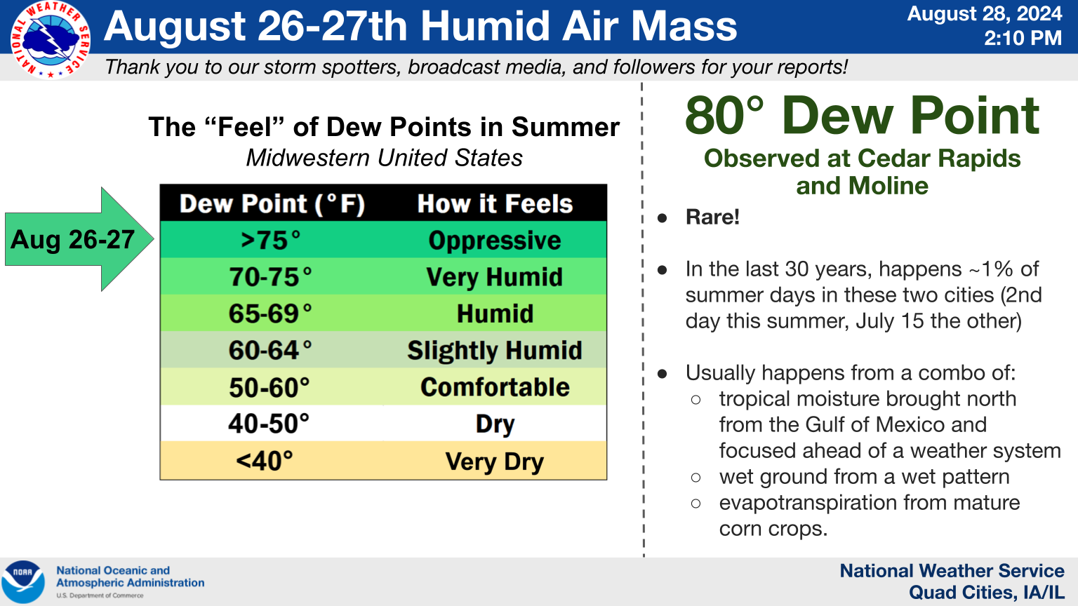
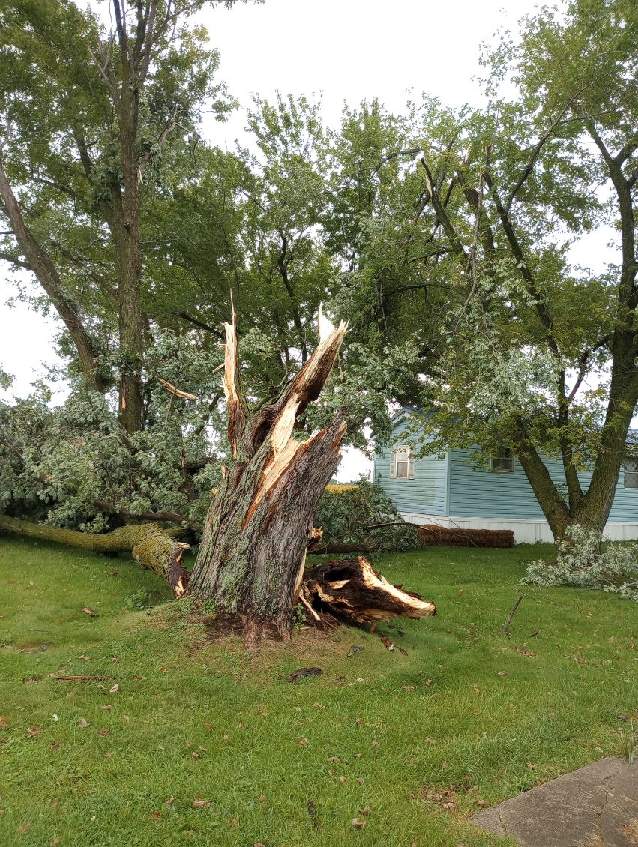
Showers and thunderstorms developed late in the day on Aug 27th in northeast Missouri and spread into southeast Iowa and far western Illinois into the evening. Large hail fell for nearly one half hour straight in Rutledge, MO, including as large as golf ball size. A pronounced downburst (sudden rush of wind under and near a thunderstorm) caused widespread damage in Burlington, IA knocking down trees, limbs, and powerlines. Five homes had holes in the roofs due to falling limbs. A commercial storage building had a partial roof collapse and another large tall outbuilding had partial roofing peeled back, consistent with wind estimates of 70 to 80 MPH. Rainfall totals of 2 to 4 inches were observed in parts of northeast Missouri and southeast Iowa. Oppressive heat and humidity that began on the 26th and persisted into the 27th helped spawn these storms. Both Dubuque (tied) and Moline (exceeded) daily record highs on the 27th, with Moline reaching 98° and Dubuque 94°. For more on north central and northeast Illinois, see this August 26-27 summary from NWS Chicago. |
|||||
Heat
 |
 |
 |
 |
| Records Set 8/26 & 8/27 | Record High Graphic Moline, IL |
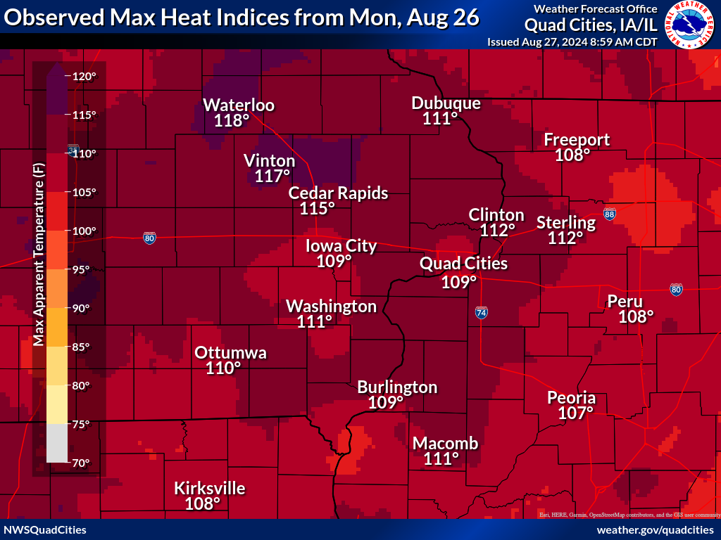
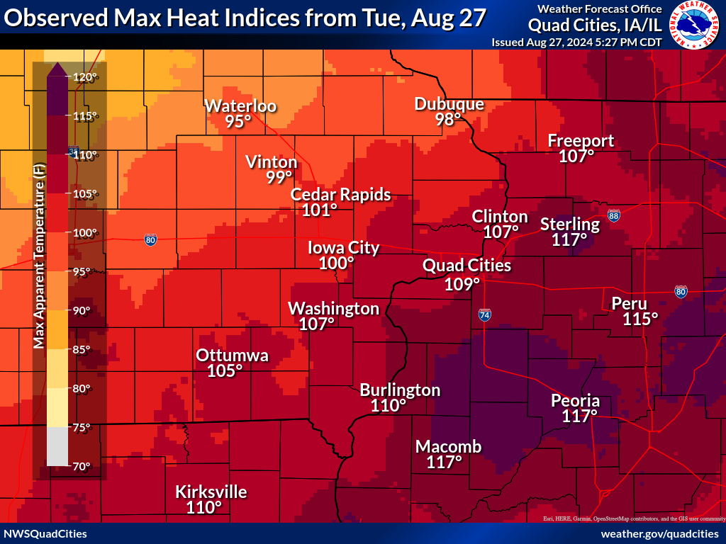
Aug. 26 Max Heat Indices | Aug. 27 Max Heat Indices |
Heat Records and Facts
Moline, IL:
Dubuque, IA:
Area-wide:
Public Information Statement
National Weather Service Quad Cities IA IL
504 PM CDT Wed Aug 28 2024

...MAXIMUM HEAT INDEX REPORTS FROM AUGUST 26-27 HEAT EPISODE...

Observations are collected from a variety of sources with varying
equipment and exposures. We thank all volunteer weather observers
for their dedication. Not all data listed are considered official.

Location                    Heat Idx.  Time/Date       Provider
---------------------------------------------------------------
Shimek State Forest          118 F     0407 PM 08/27   RAWS
Macomb Arpt                  117 F     0315 PM 08/27   AWOS
Sterling/Rock Falls Arpt     117 F     1256 PM 08/27   AWOS
Vinton Arpt                  117 F     0355 PM 08/26   AWOS
Cedar River Tnc Swamp        116 F     0446 PM 08/26   RAWS
Cedar Rapids Arpt            115 F     0352 PM 08/26   ASOS
Washington Arpt              114 F     0515 PM 08/26   AWOS
Fairfield Arpt               114 F     0635 PM 08/26   AWOS
Fort Madison Arpt            113 F     0455 PM 08/27   AWOS
Savanna Arpt                 113 F     0420 PM 08/26   AWOS
Clinton Arpt                 112 F     0456 PM 08/26   AWOS
Independence Arpt            112 F     0435 PM 08/26   AWOS
Dubuque Arpt                 111 F     0453 PM 08/26   ASOS
Mount Pleasant Arpt          110 F     0435 PM 08/27   AWOS
Burlington Arpt              109 F     0453 PM 08/27   ASOS
Davenport Arpt               109 F     0452 PM 08/26   ASOS
Iowa City Arpt               109 F     0452 PM 08/26   ASOS
Quad City Intl Arpt          109 F     0152 PM 08/27   ASOS
Freeport Arpt                108 F     0535 PM 08/26   AWOS
Keokuk Arpt                  107 F     0255 PM 08/27   AWOS
Photos
 |
|
| Damage along Missouri Highway 81 in Clark County (photo: Judy Gaston) |
Damage in Clark County, MO (photo: Judy Gaston) |
Radar
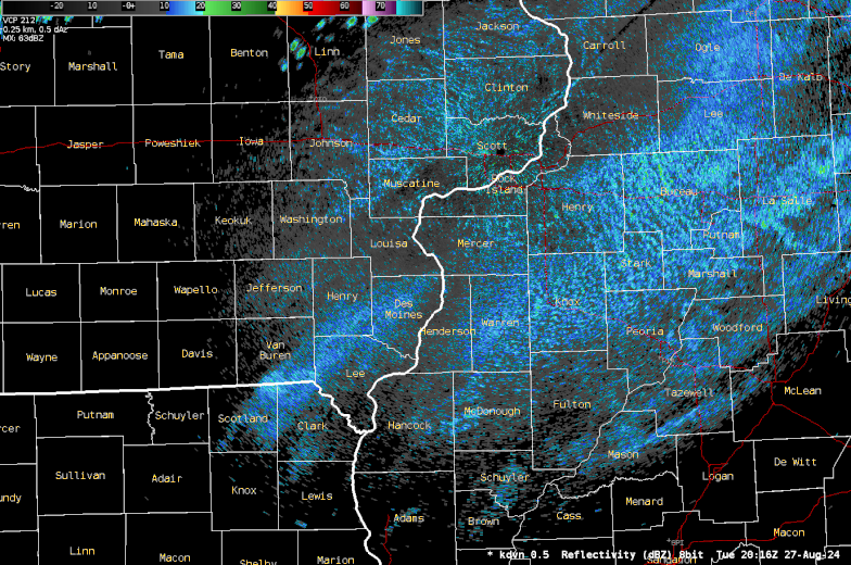 |
| Radar loop from 3:15 PM - 9:45 PM |
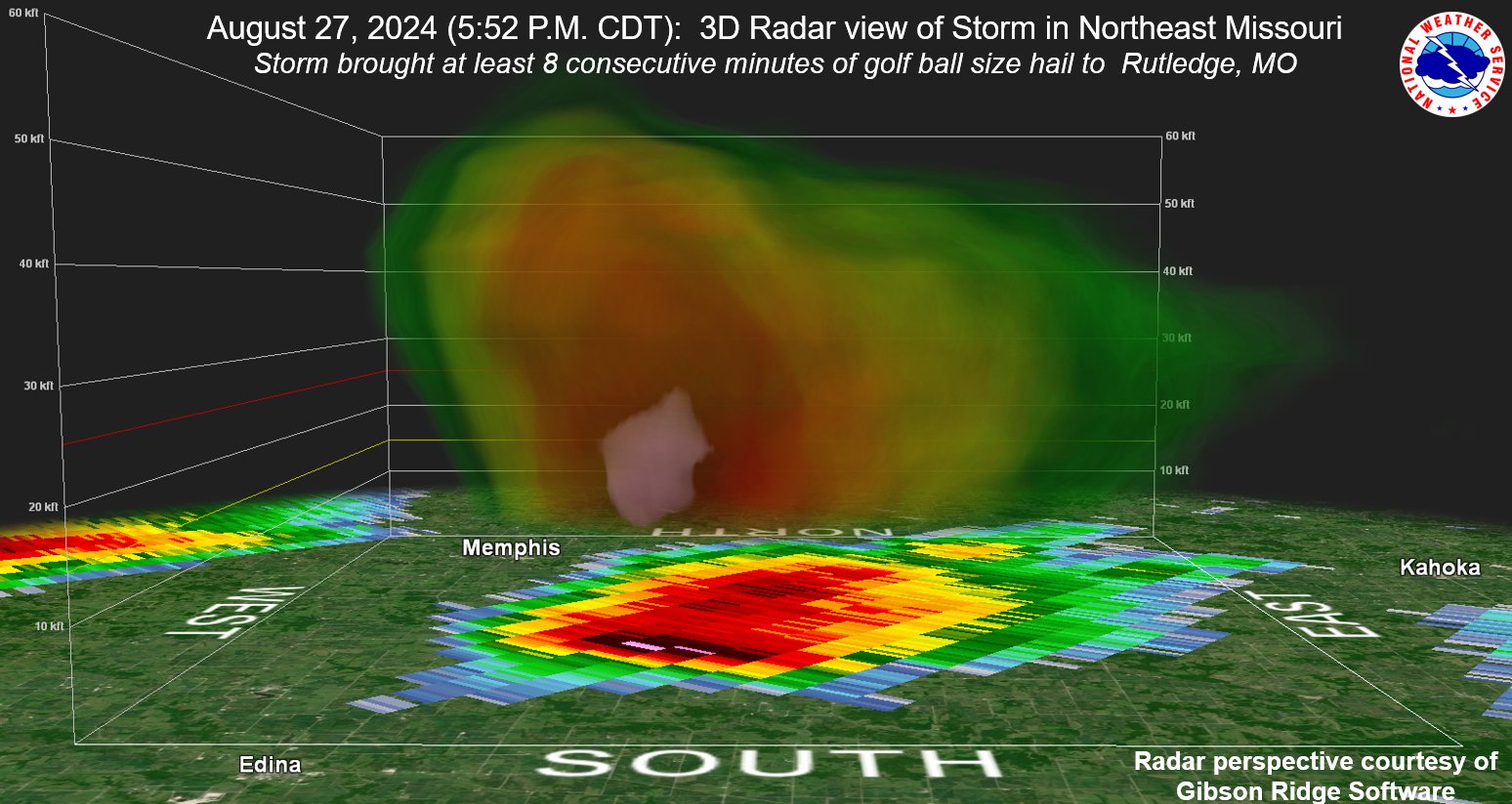 |
| Radar cross section of the storm that produced severe hail including up to golf ball size in Rutledge, MO. |
| IEM Radar Loop |
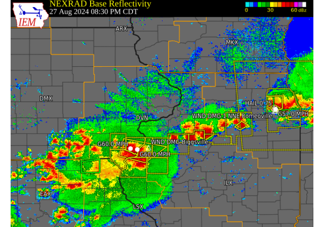 |
| IEM Radar Image at 830 PM 8/27 |
Storm Reports
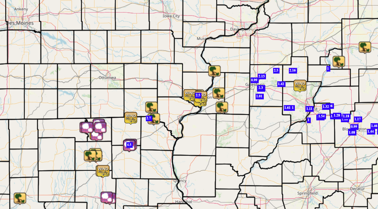
| IEM Storm Reports Map | SPC Storm Reports |
 |
 |
Preliminary Local Storm Report...Summary
National Weather Service Quad Cities IA IL
342 PM CDT Wed Aug 28 2024

..TIME...   ...EVENT...      ...CITY LOCATION...     ...LAT.LON...
..DATE...   ....MAG....      ..COUNTY LOCATION..ST.. ...SOURCE....
            ..REMARKS..

0537 PM     Hail             Rutledge                40.30N 92.11W
08/27/2024  M1.75 Inch       Scotland           MO   Trained Spotter

            Updated to indicate some damage. Hail of up
            to golf ball size persisted for at least
            eight straight minutes through 5:45 P.M.
            Dings and dents were observed on a vehicle.
            This occurred near/in town of Rutledge, just
            southeast of the town of Sand Hill.

0540 PM     Tstm Wnd Gst     Sand Hill               40.31N 92.11W
08/27/2024  E60 MPH          Scotland           MO   Trained Spotter

            Time estimated from radar.

0540 PM     Hail             Sand Hill               40.31N 92.11W
08/27/2024  M1.00 Inch       Scotland           MO   Trained Spotter

            Hail lasted 15 to 20 minutes. Time estimated
            from radar.

0608 PM     Hail             Rutledge                40.31N 92.09W
08/27/2024  E1.50 Inch       Scotland           MO   Trained Spotter

            From the same storm that produced golf ball
            size hail earlier beginning at 5:37 PM. May
            have produced severe to near-severe size
            hail for a half hour straight.

0700 PM     Tstm Wnd Dmg     1 N Anson               40.58N 91.77W
08/27/2024                   Clark              MO   Trained Spotter

            Large tree branched down. Pine tree
            uprooted. Time estimated from radar.

0705 PM     Tstm Wnd Gst     4 NE Brock              40.59N 92.09W
08/27/2024  E65 MPH          Scotland           MO   Trained Spotter

            Estimated 60-65 mph. Time estimated from
            radar.

0720 PM     Tstm Wnd Dmg     Bonaparte               40.70N 91.80W
08/27/2024                   Van Buren          IA   Trained Spotter

            Large tree branches down.

0821 PM     Tstm Wnd Gst     Burlington Regional Air 40.77N 91.13W
08/27/2024  M58 MPH          Des Moines         IA   ASOS

            ASOS station KBRL Burlington Arpt.

0827 PM     Tstm Wnd Dmg     West Burlington         40.82N 91.18W
08/27/2024                   Des Moines         IA   Emergency Mngr

            Five houses had holes in roofs from fallen
            trees. A Menards storage facility roof
            collapsed, and a roof was peeled back on an
            outbuilding. Winds were likely at least 80
            mph.

0827 PM     Tstm Wnd Dmg     West Burlington         40.83N 91.16W
08/27/2024                   Des Moines         IA   Trained Spotter

            Corrects the time of the previous tstm wnd
            dmg report from West Burlington. Reports of
            widespread wind damage in the Burlington
            area. Limbs, powerlines, and trees down
            blocking residential streets, tree down on
            home. Time of the evident was estimated
            using radar.

0830 PM     Tstm Wnd Gst     Middletown              40.83N 91.27W
08/27/2024  E60 MPH          Des Moines         IA   Trained Spotter

            60 MPH wind gust estimated, along with heavy
            rainfall restricting visibility.

0838 PM     Tstm Wnd Gst     Burlington              40.81N 91.12W
08/27/2024  E60 MPH          Des Moines         IA   Trained Spotter


0840 PM     Tstm Wnd Dmg     Biggsville              40.85N 90.87W
08/27/2024                   Henderson          IL   Trained Spotter

            60 MPH wind gust estimated, downed fencing.

0857 PM     Tstm Wnd Dmg     1 S Keithsburg          41.08N 90.93W
08/27/2024                   Mercer             IL   Trained Spotter

            Report of a tree blown down and blocking
            both lanes of 82nd Street south of
            Keithsburg.

0900 PM     Tstm Wnd Dmg     Raritan                 40.70N 90.83W
08/27/2024                   Henderson          IL   NWS Employee

            Relayed report of damage to a building on
            Main St. Also, several tree limbs down
            throughout town.

0910 PM     Tstm Wnd Dmg     Mc Nabb                 41.18N 89.21W
08/27/2024                   Putnam             IL   Public

            Relay of a public report of a 3 inch
            diameter branch blown down in a yard.

1230 AM     Rain             3 ENE Charlie Heath Mem 40.59N 91.84W
08/28/2024  M2.70 Inch       Clark              MO   Trained Spotter

            light rain continues.

1020 AM     Rain             Sand Hill               40.31N 92.11W
08/28/2024  M4.50 Inch       Scotland           MO   Trained Spotter

            Rainfall from last evening.

$$
|
|
Rain Reports: Coming Soon
 |
 |
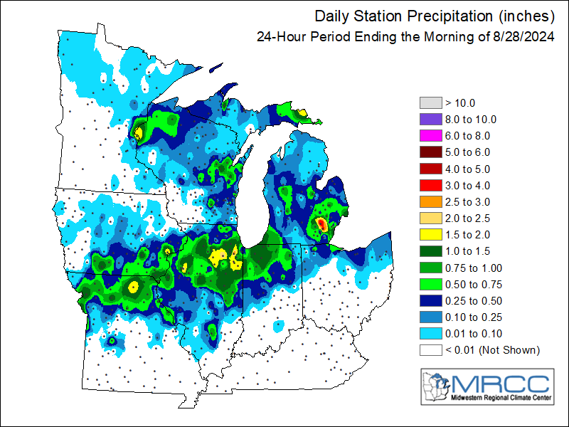
Regional Rainfall |
Local Rainfall |
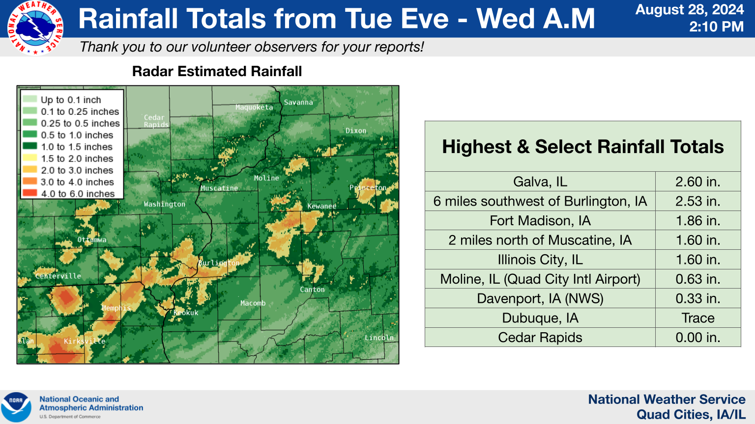
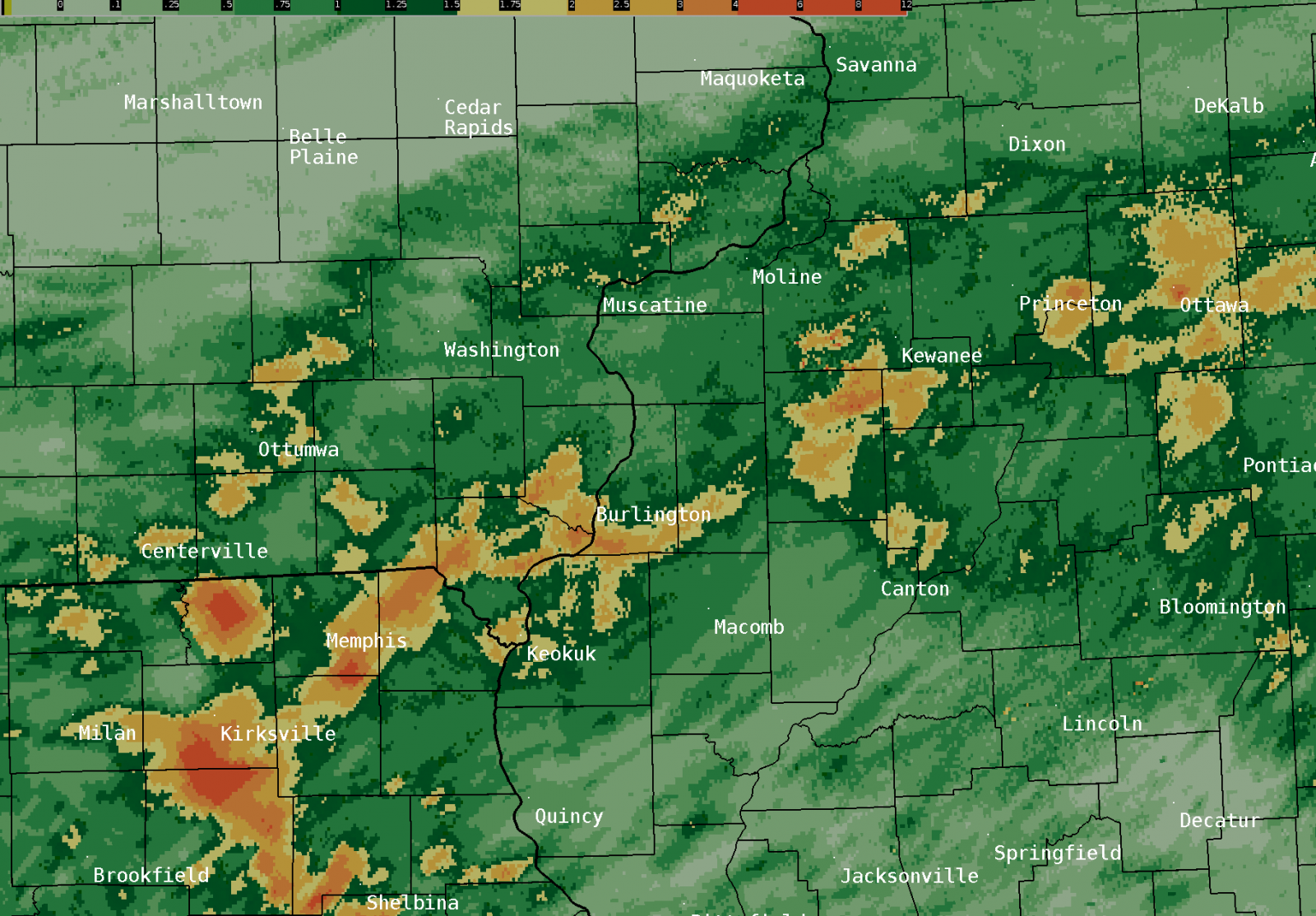
24 hour precipitation reports (in Inches), for eastern Iowa, northwest and west central Illinois, and northeast Missouri. Reported between Midnight and 9 AM, Wednesday August 28, 2024. ....IOWA.... Burlington 6.5 SSW 2.53 Burlington 0.8 SSE 2.13 Fort Madison 0.9 NE 1.86 Muscatine 1.4 N 1.85 Maysville 0.1 SW 1.76 Muscatine 2N 1.60 Donnellson 1.48 Muscatine 3.0 NE 1.43 Burlington Arpt 1.38 Keokuk 3.4 NW 1.21 Salem 3.1 ESE 1.20 Sigourney 1.17 Danville 2.9 W 1.16 Sigourney 0.4 NNE 1.00 De Witt 5.4 ENE 0.97 Hayesville 0.2 SW 0.94 Park View 0.2 WSW 0.93 Clinton 1.7 NNW 0.91 Fort Madison 4.5 NNW 0.90 Salem 1S 0.89 Yarmouth 1.9 SW 0.83 Ainsworth 7.4 N 0.83 Nichols 2.5 NNW 0.82 Clinton 1.3 NNE 0.79 North Liberty 0.7 SSW 0.74 Coralville 1.4 S 0.73 Tiffin 1.2 NE 0.72 Keosauqua 0.72 Keokuk LD19 0.71 Riverdale 0.5 N 0.70 Davenport 2.1 N 0.69 Le Claire LD14 0.67 Morning Sun 1.7 E 0.66 North English 0.66 Wellman 4.0 E 0.65 Coralville 1.3 SE 0.65 Columbus Jct 2 SSW 0.65 Wapello 0.2 S 0.61 Eldridge 0.7 SSW 0.58 Eldridge 0.6 S 0.58 Le Claire 2.0 WSW 0.55 Centerville 0.3 NE 0.54 West Point 7.5 NW 0.53 Solon 0.4 WNW 0.51 Ottumwa ASOS 5.8 NNW 0.51 New London 1.5 SW 0.48 Davenport 4.3 NE 0.47 Iowa City Arpt 0.46 Camanche 1.2 W 0.45 De Witt 0.43 Hillsboro 5.8 SE 0.42 Clarence 3.9 S 0.42 Iowa City 0.40 Lowden 0.40 Davenport Arpt 0.40 Iowa City 2.3 E 0.34 Davenport 0.9 WNW 0.33 Oskaloosa 1.4 NNW 0.32 Tipton 6.9 SSW 0.31 Iowa City 2.7 E 0.31 Pella 4 N 0.31 Mt Pleasant 1 SSW 0.29 Calamus 2.0 NE 0.28 Fairfield 5.7 NNE 0.27 Wapello 5.4 SE 0.26 Tipton 0.7 N 0.24 Pella AWOS 1.5 WSW 0.24 Williamsburg 0.6 SW 0.21 Fairfield 1.4 S 0.20 Fairfield 0.7 SE 0.20 Williamsburg 0.20 Washington 0.20 Waterloo ASOS 5.2 NW 0.19 Tipton 0.3 ESE 0.16 Oskaloosa AWOS 9.2 ESE 0.16 Welton 0.2 WNW 0.08 Hampton 1 N 0.08 Marshalltown 1.3 NW 0.06 Boone 1.3 SSW 0.06 Oelwein AWOS 0.05 Fayette 1 NW 0.05 Marengo 2.6 SSW 0.04 Hopkinton 5.4 WSW 0.03 Grinnell 2.3 SW 0.03 Manchester 0.03 Charlotte 1.9 WNW 0.02 Asbury 0.4 SW 0.02 Independence 0.9 WNW 0.02 Dundee 1.4 NNE 0.01 Elkader 6SSW 0.01 Marshalltown ASOS 4.2 N 0.01 Grinnell AWOS 2.4 SSW 0.01 NWS Johnston* 4.6 NNW 0.01 Ely 2.0 N 0.00 Shellsburg 2.9 S 0.00 Mount Auburn 2.2 NNW 0.00 Oelwein 1E 0.00 Mason City 0.9 NNE 0.00 Mason City ASOS 6.3 W 0.00 Dubuque Arpt 0.00 Parnell 0.1 SSW 0.00 Anamosa 0.6 ESE 0.00 Center Junction 2.6 W 0.00 Marion 0.9 NE 0.00 Robins 0.8 SE 0.00 Ely 0.5 SE 0.00 Marion 1.7 NNW 0.00 Fairfax 4.0 NW 0.00 Bellevue 12.2 NW 0.00 Guttenberg Dam 10 0.00 Bellevue LD12 0.00 Cedar Rapids Arpt 0.00 Belle Plaine 0.00 Anamosa 3 SSW 0.00 Vinton 0.00 Monticello 1 E 0.00 |
....ILLINOIS.... Galva 0.9 SE 2.60 St Anne 1.92 Ottawa 4 SW 1.80 Streator 3 SE 1.68 Ill. City LD16 3 WNW 1.60 Atkinson 2.6 NNE 1.40 Woodhull 0.3 ESE 1.10 Monmouth 0.4 SE 1.09 Romeoville 1.08 La Harpe 1.03 Geneseo 2.0 NW 1.01 Moline 0.7 NNE 1.00 Tuscola 0.98 Ogden 0.95 New Windsor 2.0 N 0.91 Mendota 2 SE 0.91 Stronghurst 0.4 SSW 0.90 Tampico 4.3 S 0.88 Galesburg 0.85 Joliet Arpt 0.78 Colona 0.5 ESE 0.77 Bloomington Airport 0.75 Fulton LD13 0.72 New Boston LD17 0.70 Peoria Arpt 0.68 Quad City Arpt 0.63 Alpha 2.3 N 0.55 Viola 0.4 E 0.51 Lanark 5.3 N 0.47 Aledo 0.47 Taylor Ridge 1.1 N 0.45 Monmouth 4NW 0.45 Shannon 2.7 E 0.44 Warsaw 5.8 SE 0.43 Mount Carroll 0.43 Rock Falls 3.1 S 0.39 Davis 0.5 N 0.39 Colchester 3.5 NE 0.38 Sterling 5.9 NNE 0.38 Mount Carroll 6.8 NNW 0.34 Lincoln NWS 0.31 Gladstone LD18 0.30 Steward 0.29 Lanark 4.2 NNW 0.28 Freeport 0.24 Rockford Arpt 0.22 Walnut 5.3 ENE 0.21 Freeport 4.3 W 0.20 Quincy Arpt 0.19 Rochelle Arpt 0.17 Augusta 0.16 Morrison 3.2 E 0.15 Decatur Airport 0.10 Jacksonville 2E 0.08 Winslow 4.3 ESE 0.03 Jacksonville Arpt 0.03 Lena 0.3 SSE 0.00 East Dubuque 1.7 SE 0.00 Stockton 3.4 NNE 0.00 Hanover 0.2 NW 0.00 Windsor 0.00 Elizabeth 0.00 Stockton 3 NNE 0.00 |
....MISSOURI.... Kirksville Arpt 3.11 Chillicothe Arpt 0.61 Kahoka 5.2 ESE 0.36 Columbia Arpt 0.03 |
Environment
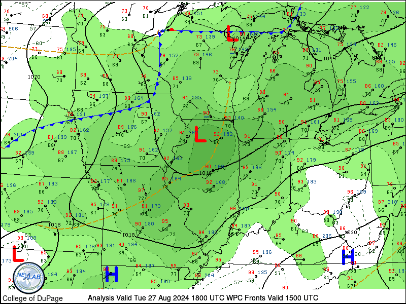
|
Aug 27, 2024 Surface Map Loop |
 |
Media use of NWS Web News Stories is encouraged! |
|