Scattered severe thunderstorms capable of damaging wind gusts and some hail are expected this afternoon and evening from the Upper Ohio River Valley into the Northeast, and from the Appalachians into the Mid-Atlantic States. Excessive rainfall from heavy thunderstorms may produce areas of flash flooding from southern New Mexico into the western and northern Gulf Coast into Wednesday. Read More >
Overview
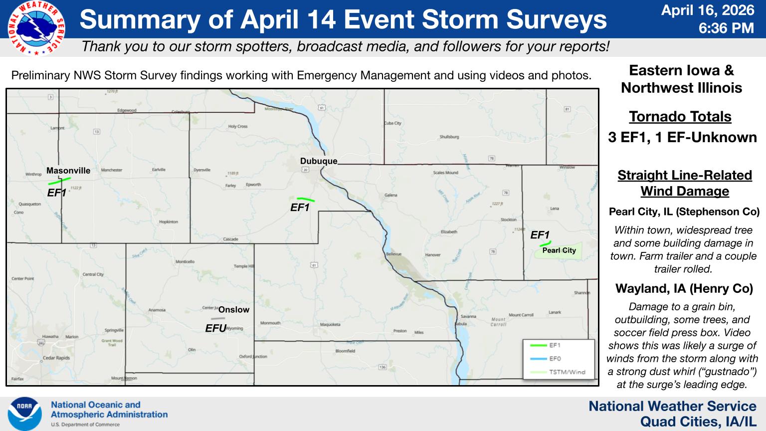
Significant severe storms on the afternoon and evening of April 14th brought numerous reports of large hail, damaging wind, and multiple tornadoes. The U.S. Hwy 20 corridor saw a long lived supercell that producing large hail (up to baseball size), damaging wind (88 mph gust at the Dubuque Airport), and several tornadoes. Additional storms developed further south between I-80 and Hwy 20 that brought large hail and a photogenic tornado near Onslow, IA.
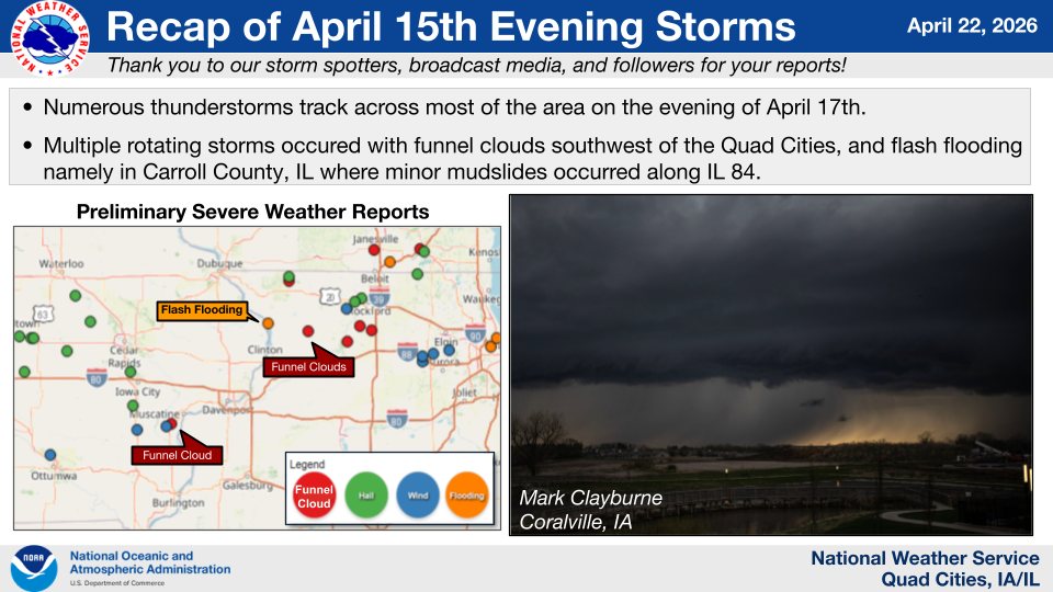
More storms quickly followed overnight and again on the next day, April 15th, bringing heavy rain, large hail, and isolated wind damage. Rainfall amounts over 1.5" were common north of I-80, with the highest totals over 3.5" seen in northwest IL. This caused a mudslide on Hwy 84 in Carroll County closing the road for an extended period of time.
|
|
 |
| April 14th Event Infographic |
April 15th Event Infographic |
Tornadoes
Select a tornado from the table to zoom into the track and view more information. The default table view is limited to 8 tracks, but can be scrolled by a mouse wheel or dynamically expanded. Additionally, the table can fill the entire window by clicking the small circular expanding arrow icon at the very top right of the table and returned to its original size by clicking the button again. The side information panel that opens over the map can be closed using the "X" on the upper right corner of the pop-up. Zoom into the map and click damage points to see detailed information and pictures from the surveys.
Public Information Statement on Event Damage Surveys
|
NOTE: times shown below are local to your device's time zone. |

The Enhanced Fujita (EF) Scale classifies tornadoes into the following categories:
| EF0 Weak 65-85 mph |
EF1 Moderate 86-110 mph |
EF2 Significant 111-135 mph |
EF3 Severe 136-165 mph |
EF4 Extreme 166-200 mph |
EF5 Catastrophic 200+ mph |
 |
|||||
| Tornadoes that fail to impact any ratable damage indicators on the EF-Scale are rated EF-Unknown (EF-U) | |||||
 |
 |
| Buchanan and Delaware Counties, IA Tornado | Jones County, IA Tornado |
 |
 |
| Dubuque County, IA Tornado | Stephenson County, IL Tornado |
Storm Reports
 |
 |
Preliminary Local Storm Report...Summary
National Weather Service Quad Cities IA IL

..TIME...   ...EVENT...      ...CITY LOCATION...     ...LAT.LON...
..DATE...   ....MAG....      ..COUNTY LOCATION..ST.. ...SOURCE....
            ..REMARKS..

0502 PM     Hail             3 E Otterville          42.52N 91.89W
04/14/2026  M3.25 Inch       Buchanan           IA   Emergency Mngr

            Image from Buchanan County Emergency Manager
            in NWS Chat. Time estimated from radar.

0505 PM     Hail             1 N Independence        42.49N 91.89W
04/14/2026  E1.75 Inch       Buchanan           IA   Trained Spotter


0506 PM     Hail             4 NNE Independence      42.52N 91.86W
04/14/2026  M2.75 Inch       Buchanan           IA   Public

            Time estimated from radar.

0506 PM     Hail             Belle Plaine            41.90N 92.27W
04/14/2026  E1.00 Inch       Benton             IA   Public

            Occurring right now and coming down real
            good.

0508 PM     Tstm Wnd Dmg     1 S Independence        42.44N 91.89W
04/14/2026                   Buchanan           IA   NWS Storm Survey

            Sheet metal off a building roof. This was
            determined to likely be from a rear flank
            downdraft (RFD) based on nature of damage
            and trained spotter videos.

0509 PM     Hail             2 NE Independence       42.49N 91.87W
04/14/2026  M1.25 Inch       Buchanan           IA   Public

            Report from mPING: Half Dollar (1.25 in.).

0509 PM     Hail             1 SW Vinton             42.15N 92.03W
04/14/2026  M1.00 Inch       Benton             IA   Fire Dept/Rescue


0511 PM     Hail             2 ESE Mount Auburn      42.24N 92.05W
04/14/2026  M1.00 Inch       Benton             IA   Trained Spotter


0516 PM     Hail             Urbana                  42.22N 91.88W
04/14/2026  E1.00 Inch       Benton             IA   Trained Spotter


0522 PM     Hail             Van Horne               42.01N 92.09W
04/14/2026  M1.75 Inch       Benton             IA   Emergency Mngr

            Time estimated from radar.

0523 PM     Hail             4 SW Newhall            41.96N 92.04W
04/14/2026  E1.25 Inch       Benton             IA   Public

            Report from mPING: Half Dollar (1.25 in.).

0524 PM     Hail             4 SW Van Horne          41.96N 92.12W
04/14/2026  E1.00 Inch       Benton             IA   Public

            Report from mPING: Quarter (1.00 in.).

0525 PM     Tornado          3 WSW Masonville        42.45N 91.65W
04/14/2026                   Buchanan           IA   NWS Storm Survey

            An EF1 tornado began east-southeast of
            Winthrop and tracked into Delaware County to
            just east-southeast of Masonville. A barn
            was completely destroyed at the beginning of
            its 4.3 mile long path. Additional damage to
            outbuildings and numerous trees was
            observed. The tornado also crossed U.S.
            Highway 20 just south of Masonville. The
            tornado did roll over a semi trailer.

0525 PM     Hail             Van Horne               42.01N 92.09W
04/14/2026  E2.00 Inch       Benton             IA   Trained Spotter


0526 PM     Hail             2 S Fairfax             41.89N 91.78W
04/14/2026  M1.75 Inch       Linn               IA   Public


0528 PM     Hail             1 NE Fairfax            41.93N 91.76W
04/14/2026  M1.75 Inch       Linn               IA   Public

            Report from mPING: Golf Ball (1.75 in.).

0529 PM     Hail             1 NE Fairfax            41.93N 91.77W
04/14/2026  E1.25 Inch       Linn               IA   Public

            Report from mPING: Half Dollar (1.25 in.).

0531 PM     Hail             3 W Cedar Rapids        41.96N 91.72W
04/14/2026  E1.00 Inch       Linn               IA   Public

            Report from mPING: Quarter (1.00 in.).

0535 PM     Hail             2 ENE Cedar Rapids      41.98N 91.64W
04/14/2026  E1.75 Inch       Linn               IA   Public


0537 PM     Hail             Packwood                41.13N 92.08W
04/14/2026  E2.00 Inch       Jefferson          IA   Public

            Time estimated using radar.

0540 PM     Hail             3 SE Packwood           41.11N 92.05W
04/14/2026  M1.00 Inch       Jefferson          IA   Trained Spotter

            Trained spotter report. Time estimated from
            radar.

0543 PM     Hail             3 SW Marion             42.01N 91.63W
04/14/2026  M1.00 Inch       Linn               IA   Trained Spotter


0545 PM     Hail             1 S Marion              42.02N 91.59W
04/14/2026  M1.25 Inch       Linn               IA   Trained Spotter

            Trained spotter report. Time estimated from
            radar.

0547 PM     Hail             2 E Marion              42.04N 91.56W
04/14/2026  E1.00 Inch       Linn               IA   Public

            Report from mPING: Quarter (1.00 in.).

0548 PM     Hail             Jesup                   42.48N 92.07W
04/14/2026  E1.75 Inch       Buchanan           IA   Emergency Mngr

            EM report from Jesup. Time estimated from
            radar.

0548 PM     Hail             Wellman                 41.47N 91.84W
04/14/2026  E1.75 Inch       Washington         IA   Law Enforcement

            Public report relayed by law enforcement.
            Time estimated from radar.

0550 PM     Hail             2 NNE Marion            42.05N 91.57W
04/14/2026  M1.50 Inch       Linn               IA   Trained Spotter


0551 PM     Hail             1 SE Ryan               42.34N 91.46W
04/14/2026  E1.00 Inch       Delaware           IA   Public

            Report from mPING: Quarter (1.00 in.).

0552 PM     Hail             2 NW Marion             42.05N 91.61W
04/14/2026  E1.00 Inch       Linn               IA   Public

            Report from mPING: Quarter (1.00 in.).

0553 PM     Tstm Wnd Dmg     1 ENE Delhi             42.43N 91.32W
04/14/2026                   Delaware           IA   Emergency Mngr

            Emergency Manager reported damage to a
            machine shed near Delhi. Tornado possible.

0554 PM     Hail             3 NW Pleasant Plain     41.18N 91.89W
04/14/2026  E1.75 Inch       Washington         IA   Trained Spotter

            Time estimated by radar.

0602 PM     Hail             3 SW Delhi              42.40N 91.36W
04/14/2026  E1.00 Inch       Delaware           IA   Public

            Report from mPING: Quarter (1.00 in.).

0608 PM     Hail             Iowa City               41.66N 91.54W
04/14/2026  E1.50 Inch       Johnson            IA   Public

            Time estimated from radar.

0610 PM     Hail             1 NE University Heights 41.66N 91.55W
04/14/2026  E1.25 Inch       Johnson            IA   Public

            Report from mPING: Half Dollar (1.25 in.).

0611 PM     Hail             1 NNE Iowa City         41.67N 91.53W
04/14/2026  E1.00 Inch       Johnson            IA   Trained Spotter


0612 PM     Hail             2 NW Iowa City          41.68N 91.55W
04/14/2026  E1.00 Inch       Johnson            IA   Public

            Report from mPING: Quarter (1.00 in.).

0612 PM     Hail             1 W Iowa City           41.66N 91.55W
04/14/2026  M1.25 Inch       Johnson            IA   Trained Spotter


0617 PM     Hail             1 WSW Langworthy        42.18N 91.23W
04/14/2026  M1.00 Inch       Jones              IA   Trained Spotter


0620 PM     Tstm Wnd Dmg     Wayland                 41.15N 91.66W
04/14/2026                   Henry              IA   NWS Storm Survey

            What was likely rear flank downdraft (RFD)
            winds and a strong dust whirl or gustnado on
            this wind surge based on video, which
            included cloud features as well as the
            nature of the damage. The damage was to a
            grain bin and an outbuilding, branches down
            in town, a tree downed, and to the press box
            at the soccer field at the high school.

0621 PM     Hail             3 NW Center Junction    42.14N 91.13W
04/14/2026  E1.00 Inch       Jones              IA   Public

            .

0621 PM     Hail             4 NW Cascade            42.33N 91.08W
04/14/2026  E1.50 Inch       Dubuque            IA   Public

            Report from mPING: Ping Pong Ball (1.50
            in.).

0627 PM     Tornado          2 WSW Onslow            42.09N 91.05W
04/14/2026                   Jones              IA   NWS Storm Survey

            EFU tornado confirmed based on multiple
            chaser videos and spotter reports. No known
            damage along its estimated 2.6 mile path.
            Tornado path determined by radar and video
            evidence.

0629 PM     Hail             Noble                   41.17N 91.62W
04/14/2026  E2.00 Inch       Washington         IA   Trained Spotter


0630 PM     Hail             3 S Crawfordsville      41.18N 91.55W
04/14/2026  E1.50 Inch       Washington         IA   Storm Chaser

            Storm chaser report. Time estimated from
            radar.

0632 PM     Tstm Wnd Dmg     Manchester              42.47N 91.35W
04/14/2026                   Delaware           IA   Trained Spotter

            Small tree branches/ limbs down.

0636 PM     Tornado          2 NW Dubuque Regional A 42.42N 90.74W
04/14/2026                   Dubuque            IA   NWS Storm Survey

            An EF1 tornado began just northwest of the
            Dubuque Regional Airport. Max winds of 100
            to 105 mph was observed. The tornado caused
            damage to trees, snapping and uprooting
            trees along its path. A newly constructed
            home had roof damage on three sides of the
            roof.

0641 PM     Tstm Wnd Gst     Dubuque Regional Arpt   42.40N 90.72W
04/14/2026  M88 MPH          Dubuque            IA   ASOS

            ASOS.

0648 PM     Hail             4 SE Langworthy         42.13N 91.18W
04/14/2026  M1.00 Inch       Jones              IA   Trained Spotter


0649 PM     Hail             2 W South Gary Owen     42.23N 90.85W
04/14/2026  E1.50 Inch       Jackson            IA   Public

            Report from mPING: Ping Pong Ball (1.50
            in.).

0650 PM     Hail             2 ENE Onslow            42.12N 90.98W
04/14/2026  M3.00 Inch       Jones              IA   Emergency Mngr

            Photo provided. Time estimated using radar.

0715 PM     Hail             Bellevue                42.26N 90.43W
04/14/2026  M1.00 Inch       Jackson            IA   Trained Spotter


0726 PM     Tstm Wnd Gst     3 N Stockton            42.40N 89.99W
04/14/2026  M51 MPH          Jo Daviess         IL   Trained Spotter


0737 PM     Tstm Wnd Dmg     1 SSW Stockton          42.34N 90.01W
04/14/2026                   Jo Daviess         IL   NWS Storm Survey

            Power poles downed just south of Stockton.
            This was determined to be done by
            straight-line winds.

0739 PM     Tornado          2 NW Pearl City         42.29N 89.86W
04/14/2026                   Stephenson         IL   NWS Storm Survey

            A tornado formed briefly in the occlusion of
            an RFD northwest of Pearl City. It heavily
            damaged and destroyed several farm
            outbuildings, lifted a large farm wagon into
            an outbuilding, damaging the roof and side.
            The tornado also snapped several tree trunks
            and tree damage. Power poles were also
            snapped as the tornado crossed Illinois
            Highway 73 before lifting shortly
            thereafter. The tornado caused EF-1 damage
            with maximum estimated winds of 105 mph.

0745 PM     Tstm Wnd Dmg     Pearl City              42.27N 89.83W
04/14/2026                   Stephenson         IL   NWS Storm Survey

            Widespread wind damage in and east of Pearl
            City was consistent with wind gusts of 80 to
            95 mph. Damage was to trees, numerous
            snapped half way up and some uprooted, as
            well as some structural damage including a
            coffee trailer rolled.

0750 PM     Flash Flood      1 N Cottonville         42.25N 90.60W
04/14/2026                   Jackson            IA   Public

            Public video of significant creek flash
            flooding relayed by local media.

0800 PM     Flash Flood      2 W Delaware            42.47N 91.38W
04/14/2026                   Delaware           IA   Emergency Mngr

            EM reports multiple roads washed out across
            the county.

0820 PM     Flash Flood      2 SSE Elmoville         42.24N 90.03W
04/14/2026                   Jo Daviess         IL   Emergency Mngr

            Illinois Highway 78 was closed numerous
            hours through early overnight due to water.

0829 PM     Rain             Lore                    42.51N 90.79W
04/14/2026  M1.48 Inch       Dubuque            IA   Trained Spotter

            Storm Total Rainfall since 5pm CDT.

0836 PM     Flash Flood      Masonville              42.48N 91.60W
04/14/2026                   Delaware           IA   Law Enforcement

            Part of roadway washed out with water over
            the road, barricaded off by fire department.

0901 PM     Rain             Hanover                 42.25N 90.27W
04/14/2026  M2.25 Inch       Jo Daviess         IL   Trained Spotter

            since 7 pm.

0848 AM     Rain             2 SW Saint Donatus      42.35N 90.57W
04/15/2026  M1.78 Inch       Jackson            IA   Trained Spotter

            24 hour rain total.

0531 PM     Hail             3 S Vinton              42.12N 92.03W
04/15/2026  M1.00 Inch       Benton             IA   Emergency Mngr


0619 PM     Funnel Cloud     2 S Nora                42.43N 89.94W
04/15/2026                   Jo Daviess         IL   Trained Spotter


0650 PM     Hail             Nora                    42.46N 89.94W
04/15/2026  M1.00 Inch       Jo Daviess         IL   Trained Spotter


0733 PM     Tstm Wnd Dmg     1 NE Ainsworth          41.30N 91.54W
04/15/2026                   Washington         IA   Public

            Semi tipped over on US Highway 218.

0733 PM     Funnel Cloud     3 N Hitt                42.05N 89.74W
04/15/2026                   Carroll            IL   Trained Spotter

            Funnel cloud reported north of
            Milledgeville, IL. Time and location
            estimated from radar.

0742 PM     Hail             Riverside               41.49N 91.58W
04/15/2026  E1.00 Inch       Washington         IA   Trained Spotter
0753 PM     Tstm Wnd Dmg     5 W Letts               41.33N 91.33W
04/15/2026                   Louisa             IA   NWS Storm Survey

            Section of two trees downed to the east and
            outbuilding door damage, along with a
            chimney toppled. Time estimated using radar.

0756 PM     Tstm Wnd Dmg     2 SSW Cranston          41.35N 91.28W
04/15/2026                   Muscatine          IA   Trained Spotter

            Trained spotter video showed a tree downed
            along with partial outbuilding damage on
            275th Street. This appeared to be a small
            gustnado given its due south direction of
            movement and behavior seen in the video.

0758 PM     Tstm Wnd Dmg     Letts                   41.33N 91.23W
04/15/2026                   Louisa             IA   Law Enforcement

            Powerlines down. Time estimated using radar.

0805 PM     Funnel Cloud     2 SW Muscatine Municipa 41.35N 91.18W
04/15/2026                   Muscatine          IA   Emergency Mngr

            Multiple reports from Emergency Managers of
            rotation and a funnel cloud near Fruitland,
            IA. Location and time estimated from radar.

0815 PM     Tstm Wnd Dmg     Muscatine               41.42N 91.07W
04/15/2026                   Muscatine          IA   Emergency Mngr

            Numerous large branches downed in town.

0853 PM     Flash Flood      2 NW Savanna            42.11N 90.16W
04/15/2026                   Carroll            IL   Law Enforcement

            Report that Illinois Route 84 is closed from
            Savanna-Sabula Bridge north to the south
            entrance of the Mississippi Palisades State
            Park. The road is blocked with trees, other
            debris, and minor mudslides. Radar estimates
            1 to 3 inches of rain fell in this area over
            an hour.
|
Photos
|
|
 |
 |
| Hail from Independence, IA in Buchanan County. Courtesy of Chris Hare. | Hail from Van Horne, IA in Benton County. Courtesy of Dean Vrba. | Hail from Belle Plaine, IA in Benton County. Courtesy of Danny Fisher. |
 |
 |
|
| Delhi IA - Jessica Steger Hillers | Delhi IA - Jessica Steger Hillers | Delhi IA - Jessica Steger Hillers |
 |
 |
 |
| Delhi IA - Jessica Steger Hillers | View of Onslow Tornado from Oxford Junction - Andrew and Antonio Soberanis | Onslow tornado looking west - Owen McCormick |
Rain Reports
 |
 |
|
48-hr Rainfall Ending April 16th 7 AM |
48-hr CoCoRaHS Reports Ending April 16th |
Public Information Statement
National Weather Service Quad Cities IA IL
1011 AM CDT Thu Apr 16 2026

...48 HOUR PRECIPITATION REPORTS...

Observations are collected from a variety of sources with varying
equipment and exposures. We thank all volunteer weather observers
for their dedication. Not all data listed are considered official.

Location                     Amount     Provider

...Illinois...

...Carroll County...
Mount Carroll 6.8 NNW        2.15 in    COCORAHS
Lanark 0.3 SSW               1.93 in    COCORAHS

...Jo Daviess County...
Stockton 5.9 WNW             3.87 in    COCORAHS
Elizabeth                    3.71 in    COOP
Hanover 0.2 NW               2.91 in    COCORAHS
Mount Carroll                2.52 in    CWOP
Stockton 3.4 NNE             2.38 in    COCORAHS
East Dubuque 1.7 SE          1.76 in    COCORAHS
Middleburg                   1.58 in    CWOP
Galena 0.8 WSW               1.56 in    COCORAHS

...Rock Island County...
Moline 0.7 NNE               1.70 in    COCORAHS

...Stephenson County...
Freeport 4.3 W               3.63 in    COCORAHS
Ridott 3.2 WNW               3.62 in    COCORAHS
Freeport                     3.22 in    CWOP
Freeport 2.9 WSW             2.97 in    COCORAHS
Davis 0.5 N                  2.70 in    COCORAHS
Freeport Arpt                2.22 in    AWOS
Lena 0.3 SSE                 1.91 in    COCORAHS

...Whiteside County...
Prophetstown 0.2 SW          2.36 in    COCORAHS

...Iowa...

...Benton County...
Urbana                       2.50 in    CWOP
Watkins 1 NE                 1.96 in    AWS
Mount Auburn                 1.93 in    CWOP
Vinton                       1.72 in    HADS

...Buchanan County...
Independence 0.9 WNW         2.61 in    COCORAHS

...Cedar County...
Tipton 0.3 ESE               1.59 in    COCORAHS

...Clinton County...
Wheatland                    1.68 in    CWOP

...Delaware County...
Manchester Airport 2 NNW     3.61 in    AWS
Manchester                   3.40 in    CWOP
Dundee 1 NE                  2.99 in    COCORAHS
Hopkinton 5.4 WSW            1.76 in    COCORAHS

...Dubuque County...
Dubuque 1.4 WNW              2.28 in    COCORAHS
Peosta 2.9 E                 2.07 in    COCORAHS
Dubuque Arpt                 1.85 in    ASOS
Waupeton                     1.82 in    HADS
Bellevue 12.2 NW             1.80 in    COCORAHS

...Iowa County...
North English                1.54 in    COOP

...Jackson County...
Maquoketa 0.8 ENE            1.65 in    COCORAHS

...Johnson County...
West Branch 2.3 SSW          1.88 in    COCORAHS

...Linn County...
Coggon 0.3 ENE               1.87 in    COCORAHS
Center Point                 1.65 in    COCORAHS
Central City 6.7 W           1.50 in    COCORAHS

...Washington County...
Ainsworth 7.4 N              1.92 in    COCORAHS
Environment
Mesoscale Summary
|
|
 |
| Tuesday, April 14, 6 PM CDT Surface Analysis |
Wednesday, April 15, 2 PM CDT Surface Analysis |
Near-Storm Environment Summary
 |
 |
 |
|
4/14 - 18z DVN Sounding |
4/14 - 21z DVN Sounding |
4/15 - 00z DVN Sounding |
SPC Outlooks
 |
 |
 |
 |
|
April 14 Convective Outlook |
Tornado Threat |
Hail Threat |
Wind Threat |
 |
 |
 |
 |
|
April 15 Convective Outlook |
Tornado Threat |
Hail Threat |
Wind Threat |
Severe/Tornado Watches & MCDs
 |
 |
 |
 |
|
Tornado Watch 109 |
MCD 425
|
MCD 431 |
 |
 |
 |
 |
|
Severe Thunderstorm Watch 117 |
 |
 |
 |
| MCD 454 |
Tornado Watch 122 |
 |
Media use of NWS Web News Stories is encouraged! Please acknowledge the NWS as the source of any news information accessed from this site. |
|